This is a post to let my viewers know I have moved my blog. About a year ago now I have been invited to make weather posts at a very well known website called Iowa Weather Network. They welcomed the same kinds of posts I've been making here, including my horticultural posts, they even created a gardening tab just for me! For the past year I've been making double sets of posts, one here and then copying the same post and making one to Iowa Weather Network. I also stopped making forecast posts which other staff members of Iowa Weather Network can provide for me. As for my remaining posts, I have received a much higher frequency of viewers and a wider market at Iowa Weather Network so I've decided it would be easier just to maintain one blog with them. I will be keeping this blog open for sentimental reasons that I've had it since 2008.
By focusing on just 1 blog viewers can expect higher quality posts from me and forecasting brought back into service by other members. There are also many great add ons there.
For continued service from me and other great services please go to Iowa Weather Network and be sure to look up the gardening tab!
Photo1


Iowa Weather Network Warnings Map

Saturday, November 22, 2014
Thursday, October 23, 2014
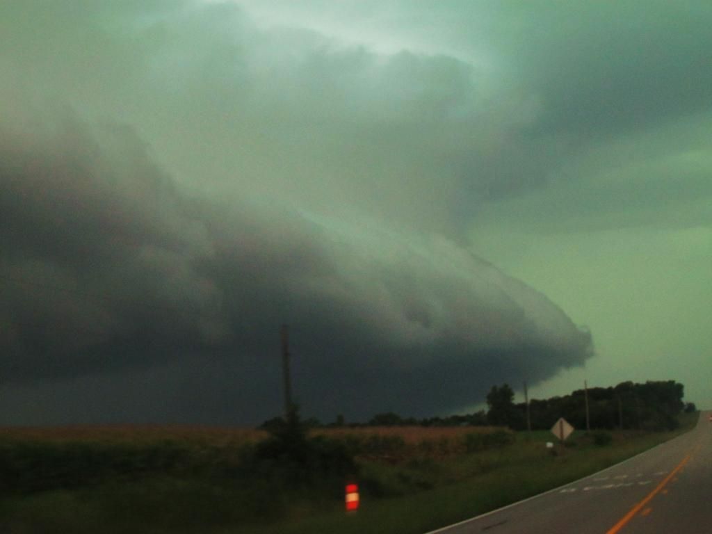
Fall color report #7 Peak color arrives in Southern Iowa!

We have reached peak color here in Des Moines! Color is at its highest and and is not expected to get brighter here in southern Iowa. Even interesting to note, even though we have reached peak there is still a descent amount of green in some areas. About 90% of trees have turned color here in Des Moines. This year has been a great year for colors as they have been outstanding. Oaks are beautiful shades of orange, burgundy and yellow. Maples are orange, yellow and red. Hickory trees are golden yellow, Ginkgo trees are gold, and burning bushes and sumac are the most intense red at this time. It's a great time to view fall colors so make sure you get out there! This will be the last weekend for best viewing! Warm temperatures ahead will likely quickly expire the best colors. Don't forget about Iowas native prairie areas! Prairie are their most beautiful in fall when grasses turn in their fall colors. I drove past some over the past couple days and they are just outstanding right now!

Fall color report #7
The regional map reviles that the northern part of Iowa is now past peak and the best colors have faded. The rest of the start, including southern and parts of central Iowa are at peak now and should be enjoyed! Friends in Northern Missouri, Kansas and Southern Illinois should be prepared to be next in line for peak fall color, as they will be there next week. I expect because of the warmth ahead, most of Iowa will be past peak by mid to end of the week next week.
Sunday, October 19, 2014
Fall color report #6 Color is peaking or high across all of Iowa. Now is the time to enjoy!

Fall color continues to progress very fast here in southern Iowa. Color is now abundant and beautiful in all trees species. Maples are turning beautiful shades of burgundy, fire red,orange and yellow. Silvers maples and Hickories are turning golden yellow. Oaks are turning yellow and red. 63rd street between West Des Moines and Norwalk is especially beautiful right now. Looking at the entire tree canopy shows color is high and painted with beautiful colors, and it looks great with the Des Moines city skyline! I would rate Des Moines at High Color with 80% of trees now turned colors. Peak fall color should happen by the end of this upcoming week. Now is the time to see colors in this part of Iowa so get out and enjoy!

Now the entire state of Iowa is either in high or peak color. Fall color is now at its peak roughly north of Highway 20. Spencer is still holding only peak color, but I've heard that trees are loosing leaves quite fast in the northern part of the state. South of 20 high color is being found and it is great for viewing. I expect the northern part of Iowa will be past peak by the end of next week and the remainder of the start will reach its peak in the next few days to the end of this week. Be sure to get out and enjoy these beautiful colors!
Thursday, October 16, 2014
Fall Color Report #5 Color is high in the north. Also what were the highs seen on this beautiful day?

Fall colors are continuing to progress quickly this week across the area. I would put Des Moines now at Moderate Color with 50% of the trees now showing at least some color. Now every city street has at least some color showing in some trees. Streets with Maples, Hackberries or Ash are beautiful and showing lots of color. Burning bushes are also beautiful shades of fire red right now. Sugar Maples are especially beautiful at this time showing shades of orange red yellow and green on one tree. One spot in particular is on the east side of Des Moines in one of the neighborhoods off 235 where there are several established Sugar Maples turning. Looking at the entire tree canopy now shows dotted trees turning colors or orange, yellow and red. However even with all this there is still a large percentage of mid to late turning trees such as Oaks, Poplars and Basswoods which are still very green. Now through the next week and a half is the time to see beautiful colors in the Des Moines area and Southern Iowa.

Fall color report #5
The fall color map now shows the northern part of Iowa has reached peak or has high color. Now is the time to view fall colors in such places as Decorah, Spencer, Mason City and Waterloo, as colors are high and as bright as they are going to be, so if in this area get out and enjoy! The rest of the state has now progressed to moderate color. Colors have actually started to come in so fast that in some areas fall colors have went right to high color category just in the last few days. Recent frosts have helped triggered the progression of colors. If everything continues as scheduled the rest of the state should start to reach high or peak color next week or the last week of October.
Today would have been a beautiful day for viewing the fall foliage as highs were in the low to mid 70s statewide. It certainly felt like a summers day in the middle of October! Below is a list of highs reached in southern central Iowa
Des Moines-Fairmount Park 76.F
Des Moines International Airport 76.F
Perry 76.F
Norwalk 76.F
Ankeny 75.F
Ames 75.F
Indianola 75.F
Pella 74.F
Boone 73.F
Knoxville 73.F
Newton 73.F
Marshalltown 72.F
Monday, October 13, 2014
Fall color report #4 Cooler weather leads to increasing color change, especially in the north.

Fall color this week has picked up significantly now that cooler weather has made its way back into the picture. Sugar and Red Maples are starting to have an abundance of color. Soon those will be peaking. I've also seen Silver Maple just now starting to join the show turning yellow, Hackberry is also turning yellow. An Oak or two is starting to turn as well. In areas with early to mid changing trees, color is bright and abundant, but there are still large areas of green and even trees turning are not at their brightest yet. Ash trees have lost most of their leaves now and have past peak. Over all I would say here in Des Moines we have Low Color 40% which is a significant increase from last week. We will soon be reaching the moderate color category. I expect that will happen by the middle to end of this week.

The fall color report reflects the change in colors across the region. Moderate color has drifted into many parts of Northern Iowa including Mason City and Waterloo. I've seen photos of fall color from Northeast Iowa lately that has been very nice. If your in northern Iowa now through the next 2 weeks would be the time to start enjoying those colors! In the rest of the state low color remains but even this part of the state will soon be joining the northern part of the state, by this time northern Iowa should have an abundance of color. Peak fall colors can be expected to be moving into parts of the state by as early as next week so leafers in the north be prepared!
Tuesday, October 7, 2014
Fall color report #3 New modern map realeased! Moderate color far NW, Low color everywhere else.

Fall color this week here in Des Moines is pretty much exactly where we were last week. We virtually made no progression in fall colors with the exception that I've seen a few more sugar maples turning orange and red. Over all I rate Low color for Des Moines with only 20% of trees showing color. that have turned last week are quickly loosing leaves and even becoming bare. Bottomland trees such as Cottonwood and willows are just loosing leaves without even turning a color. Overall though when I look across the entire tree canopy I am amazed and how much is still green, even still looking summer-like in most areas. It will probably be towards the end of October that we peak in this part of Iowa.

Fall color report #3
This is a brand new map I am releasing with the help of the Iowa Weather Network group I'm a part of. Thanks to Henry L. for making it. As for the Iowa fall color report. All cities are reporting low color and showing no change. This all true with the exception of Spencer, which is now reporting moderate color. The state fall color report says fall color is most brilliant near the Minnesota border on the northwest side of the state. One thing I am noticing though is that more brilliant color is slowing moving southward from the north. I expect that more color will begin to show up in northern Iowa in the next 7 days and should show up here on my next report next week. Cooler nights will trigger better colors.
Tuesday, September 30, 2014
Fall color report #2 Still low color all areas

After a fast start to the fall color season, fall color progression has really slowed this week because of a spell of summer-like temperatures where we had several days in the low to mid 80s. This caused the trees that have turned to start dropping leaves quite fast, but delayed others from really turning. Ash trees are loosing leaves at a fast rate now. About the only change in Des Moines this week from last week is that more ash and some hackberry have turned and I am now seeing a few Sugar maples starting to turn orange, but for the most part I have only see dull yellow to golden yellow in those trees mentioned. In areas where there are an abundance of earlier changing trees it may appear more colorful, but mid to late turning trees are still green.

As I look at the entire tree canopy there is a large percentage that has not turned. I would say were up to 20%-Low color in Des Moines and thats about it. This was enough to move us into the low category. Cold weather is expecting to move in this week which should push our fall colors out more.

Little has changed in the fall color report. The only difference is that remainder of Iowa was put into the low color category. Much of Iowa is still green at this time. Reading the state fall color report showed little change from last week in terms of color. Hopefully the next weeks colder weather will push the trees to begin turning more. If you want to see stunning fall color head to northern Minnesota and Wisconsin! Their report shows that area is peaking right now.
Monday, September 22, 2014
Iowa fall color report #1

Fall color is quickly starting across Iowa and color has become quite abundant in earlier changing trees. This change literally seemed to occur just in the past couple of days here in the Des Moines area. Tree showing color are strictly pretty much the ash species. They are turning colors of golden yellow in many boulevards around shopping centers and along roadsides. White ash has started to turn purple as well. As one looks hard enough you can also seen Maples starting to show a hint of reds especially in silver/red crosses such as Autumn blaze maple. I also saw a few stressed Sugar maples starting to turn orange as well. However as you look across the entire tree canopy it still appears primarily green with a few patches of color here and there. I am going with %15 color change in this area, with our area showing some color and just starting for Des Moines/southern Iowa

Fall color report #1
Fall color across Iowa show the northern and eastern part of the start is about 1 week ahead of the rest of the state. Low color is being reported in Mason City and Decorah. Here colors are more bright and there is more being seen but there is still a long ways to go before peak. The rest of the state, Waterloo, Cedar Rapids, Omaha/Council Bluffs are all reporting 15% with only some color being reported. Normal peak time for northern Iowa is the 1st week of October and the 2nd to 3rd weeks for the rest of Iowa.
Saturday, September 13, 2014
Cold temperature report. Mid to upper 30s reported with frost in northern areas

Morning fog September 13th 2014
This morning was a very chilly morning for Iowa and the entire Midwest, thanks to a huge area of high pressure which brought a large chuck of cold air southward across the middle of the country. Lows for the first time this season fell into the middle to upper 30s. Frost was reported in such places as Ames and Cambridge. The frost was light and did not cause any damage. Metro Des Moines did not have frost due to urban heating, but there was reports of some frost on rooftops. This cold snap was very early for Iowa, as 1st frost don't normally occur until into the middle of October. During this cold snap Des Moines only had highs in the middle 50s. Thursday the 11th the high was 54.F which was a new record cold high. Highs of this level are more normal for early to mid November for this area. Other parts of Iowa were colder this morning such as Mason City which had a low of 31.F, a hard frost was reported. The good news is the sun finally came out Saturday unveiling mild day. Temperatures will slowly rise to more normal levels by mid week next week, which will be in the mid 70s. Below is a list of lows reported this morning.
Lows this morning
Ames 34.F
Marshalltown 34.F
Boone 36.F
Newton 36.F
Ankeny 36.F
Knoxville 36.F
Winterset 36.F
Pella 38.F
Indianola 38.F
Des Moines International 39.F
Des Moines-Fairmount Park neighborhood ( My Station ) 39.F
West Des Moines 40.F
Thursday, September 11, 2014
September 9th 2014 storm report Sigificant flooding local area & storm chase southern Iowa, northern Missouri

Southern Iowa is still dealing with the effects from flooding from our recent rains September 9th when a frontal boundary caused the storms to develop that dropped 3-5" of rain in some areas, but especially in Madison and Warren counties. Flash flooding was reported in Winterset, Norwalk, Spring Hill and Indainaola areas and included the North river flooding over parts of Highway 28 south of Norwalk. Some of the highiest rainfall reports include 5.75" from Bevington. As of 8:41pm September 11th Highway 48 south of Norwalk remains closed due to flooding, and is expected to re open mid day Friday as the river goes below flood stage. The Des Moines airport got 3.00" of rain which broke a daily record for them. My raingauge had 1.69" of rain in it continuing a very wet streak we started in August. Since August 1st we have received 12.67" of rain. Below is a list of reports and rainfall totals on September 9th.
Norwalk 3-5" deep water on Cherry street. Street barricaded
Norwalk Highway 28 and 23rd closed, covered with water
5 miles N Indainola Summerset road closed due to flooding
4 miles SSW Winterset Pammel pard road closed due to flooding
8 miles SSW Earlham Water rescue at Pitzer Road due to flooding, no injuries
5 miles WSW East Peru 330th street closed due to flooding
6 miles NW Pella 1" Water over Dubuque drive
Bevington 5.75"
Cumming 4.46"
Spring Hill 4.08"
Indianola 2.65"
Hartford 5.41"
Des Moines Airport 3.00"
Des Moines fairmount park ( my station) 1.69"
Clive 2.11"
Knoxville 4.00"
Pella 2.65"
Prairie City 2.86"
Newton 2.78"
Earlham 3.34"
Johnston 2.14"
Southern Iowa/Northern Missouri storm chase.
Video of inflow winds near Grand River, IA
Storm chase for the day started late and me and Alex W. We left Des Moines around 4pm and were heading for storms SW of Des Moines at Creston. We hit heavy rain and storms by the time we reached Winterset and we continued to drive through the storm down 169 then to 34 towards Murray. We took a small road, R15 to Grand River where we finally left the rain, and there was a line of storms to our west. The video above was taken near Grand River as the storm approached. 30MPH inflow winds were measured.
Video of extreme lightning near Decatur City Sept 9th 2014
We continued south, then east towards Highway 2 near Decatur City. Here we experienced extremely close cloud to ground lightning. Several bolts struck and 2 of them I got on tape, like the one above.
Video of strong winds behind a storm near Eagleville, MO Sept 9th 2014
After sitting near Decatur City, IA we decided to go south towards the state line, on the way, we saw a tornado warning pop up for a storm over Eagleville. We crossed into Missouri and saw the back side of the storm at Eagleville and we missed the tornado. Power was going off and on in the town. We did see more dangerous lightning and heavy rain and flash flooding.
Thursday, September 4, 2014
September 4th warm temperature report low to mid 90s tied for the warmest day of the year

New Des Moines botanical gardens September 4th 2014
Today was a toasty and windy day across Iowa as strong southwesterly winds brought the highs into the lower to middle 90s. Heat index values were over 100.F. The warmth was thanks to a low pressure system to our north causing the warm air to surge in on winds that gusting to 30MPH at times. This warm up was in front of a much cooler airmass that is about to come down. So this could very well be one of our last real warm days of the summer season. Today tied for the warmest day of 2014 at many locations including Des Moines international with a high of 93.F. My station also tied 95.F again.
Highs and wind gusts
Des Moines Fairmount Park neighborhood 95.F
Urbandale 95.F
Des Moines international 93.F 31MPH
Indianola 92.F
Ames 91.F 28MPH
Pella 91.F 24MPH
Knoxville 91.F 30MPH
Ankeny 91.F 30MPH
Windsor Heights 91.F
Marshalltown 90.F 30MPH
Newton 90.F 30MPH
Boone 90.F 26MPH
Perry 90.F 29MPH
Winterset 90.F
Monday, September 1, 2014
August 31st severe weather, heavy rain and flash flooding and Nebraska, SW Iowa storm chase trip
Nebraska storm chasing trip
Shelf cloud west of Lincoln, NE August 31st 2014 Lincoln skyline August 31st 2014
Yesterday I had the quick opportunity to go storm chasing. Even though we knew the risk was not extreamlly high, we decided to take the risk to see something in a relatively quiet season we've had. I left West Des Moines around 1 with storm chasing friend Alex W. who drove in all the way from southern Minnesota and we headed for Nebraska and by the time we reached Omaha storms were already breaking out near the Kansas, Nebraska border.
 Wall clouds near Palmyra, Nebraska
We caught up with those storms about 40 miles southwest of Lincoln where the temperature shot up into the lower 90s with strong southerly winds. We saw elevated material quickly become nice looking shelf clouds near Crete, NE, pictured above We continued to followed these storms through SE Nebraska, we saw quarter sized hail and wall clouds all the way past the Nebraska City area into southwest Iowa. The last bout of severe weather seen was strong winds and very heavy rain in Shenandoah
 Storm clouds ahead near Lincoln, NE
One last photo you can see the edge of our large cluster of storms as we approached them from the northeast. They were looking very impressive.
Severe storm report- Central Iowa Heavy rain & flash flooding
Severe storms tracked all the way from eastern Nebraska and western Iowa before reaching the local area around 9pm last night in the form of a very large line that stretched across the entire state. This line produced wind damage, heavy rain and flash flooding in our areas as in dropped another 2-3" of rain across the area we did not need. The worst of the severe weather and damage was reported over northwest parts of the area. Many reports of 60MPH winds came in from the Dallas Center, Adel area with trees and power lines down. There was one report of minor damage in the Des Moines metro at Urbandale of trees limbs down More wind damage reports came in from Slater of trees down and Story City area of 60MPH winds. There was also 60-70MPH wind reports from Prairie City fo Knoxville areas. Des Moines international airport reported a 52MPH winds gust. There was also a funnel cloud reported southeast of Boone but a tornado did not develop. There storms were also responsible of producing flash flooding. Water was reported flowing over the roads in Minburn and near Granger. In Des Moines 6 inch water was reported over SW 9th street with cars stalling out in the water. Rainfall reports were 2-3"
At my backyard 2.45" of rain was reported bringing the August total all the way to 10.72" and I had water in the basement which I haven't had before.
Reports
Perry 58MPH wind gust
2 miles S Dawson 3" of rain fell in less then an hour
3 miles W Dallas Center 60MPH winds
Numerous reports of water over Highway 44 from Dallas Center to Minburn
10 to 12" branches down in Dallas Center
Adel Trees and powerlines down
4 miles E Minburn 64MPH wind gust
Berkley 60MPH wind gust
3 miles SW Boone Funnel cloud
Slater, large tree limbs down
Roland 60MPH wind gust
Urbandale, Tree limbs down
2 miles SSW Prairie City 59MPH wind gust
Knoxville 71MPH wind gust
Rainfall reports
4 miles ENE Dallas Center 2.62"
Mardrid 2.35"
Grimes 2.20"
Polk City 2.24"
Des Moines international 2.19"
Des Moines fairmount part neighborhood ( My station ) 2.45"
Ankeny 1.95"
Ames 2.22"
Nevada 2.26"
Marshalltown 2.40"


Shelf cloud west of Lincoln, NE August 31st 2014 Lincoln skyline August 31st 2014
Yesterday I had the quick opportunity to go storm chasing. Even though we knew the risk was not extreamlly high, we decided to take the risk to see something in a relatively quiet season we've had. I left West Des Moines around 1 with storm chasing friend Alex W. who drove in all the way from southern Minnesota and we headed for Nebraska and by the time we reached Omaha storms were already breaking out near the Kansas, Nebraska border.

We caught up with those storms about 40 miles southwest of Lincoln where the temperature shot up into the lower 90s with strong southerly winds. We saw elevated material quickly become nice looking shelf clouds near Crete, NE, pictured above We continued to followed these storms through SE Nebraska, we saw quarter sized hail and wall clouds all the way past the Nebraska City area into southwest Iowa. The last bout of severe weather seen was strong winds and very heavy rain in Shenandoah

One last photo you can see the edge of our large cluster of storms as we approached them from the northeast. They were looking very impressive.
Severe storm report- Central Iowa Heavy rain & flash flooding
Severe storms tracked all the way from eastern Nebraska and western Iowa before reaching the local area around 9pm last night in the form of a very large line that stretched across the entire state. This line produced wind damage, heavy rain and flash flooding in our areas as in dropped another 2-3" of rain across the area we did not need. The worst of the severe weather and damage was reported over northwest parts of the area. Many reports of 60MPH winds came in from the Dallas Center, Adel area with trees and power lines down. There was one report of minor damage in the Des Moines metro at Urbandale of trees limbs down More wind damage reports came in from Slater of trees down and Story City area of 60MPH winds. There was also 60-70MPH wind reports from Prairie City fo Knoxville areas. Des Moines international airport reported a 52MPH winds gust. There was also a funnel cloud reported southeast of Boone but a tornado did not develop. There storms were also responsible of producing flash flooding. Water was reported flowing over the roads in Minburn and near Granger. In Des Moines 6 inch water was reported over SW 9th street with cars stalling out in the water. Rainfall reports were 2-3"
At my backyard 2.45" of rain was reported bringing the August total all the way to 10.72" and I had water in the basement which I haven't had before.
Reports
Perry 58MPH wind gust
2 miles S Dawson 3" of rain fell in less then an hour
3 miles W Dallas Center 60MPH winds
Numerous reports of water over Highway 44 from Dallas Center to Minburn
10 to 12" branches down in Dallas Center
Adel Trees and powerlines down
4 miles E Minburn 64MPH wind gust
Berkley 60MPH wind gust
3 miles SW Boone Funnel cloud
Slater, large tree limbs down
Roland 60MPH wind gust
Urbandale, Tree limbs down
2 miles SSW Prairie City 59MPH wind gust
Knoxville 71MPH wind gust
Rainfall reports
4 miles ENE Dallas Center 2.62"
Mardrid 2.35"
Grimes 2.20"
Polk City 2.24"
Des Moines international 2.19"
Des Moines fairmount part neighborhood ( My station ) 2.45"
Ankeny 1.95"
Ames 2.22"
Nevada 2.26"
Marshalltown 2.40"
Sunday, August 31, 2014
Severe weather threats today

The SPC has issued a Slight Risk for severe storms for parts of Wisconsin, Minnesota, Iowa, Nebraska, Missouri, Kansas and South Dakota. This includes our area. There is an enhanced risk centers over Iowa, Nebraska and Kansas as well as southwest Minnesota. Depending on what happens with the current showers in Nebraska and Kansas, The storms this evening will fire over eastern Nebraska and Kansas and moved east this evening. As the storms fire there will be a risk for tornadoes. Storms will move east and transition into a line and move towards the local area likely around dusk or after dark. In our area in poses the highest risk for high winds and large hail, as well as very heavy rain and flooding. Isolated tornadoes will also be possible. Many of the local forecast models I looked at point towards Northern parts of the areas such as Ames have a higher risk for seeing severe weather. Please be aware today that there will be the risk for severe weather.
Friday, August 29, 2014
August 28th heavy rainfall event, flash flooding and river flooding reported. August now more then double the average rainfall

What a wet month this is turning out to be, more bouts of heavy rain impacted central Iowa yesterday, first in the morning, and then again in the evening hours. The morning storms brought half inch to an inch. The photo above was taken in Downtown Des Moines as a low cloud deck was set in. The tops of the 801 grand building and the wells Fargo building was not visible. Both bouts of rain are thanks to a frontal boundary that has been draped over Iowa for the past week. The night time storms brought the heaviest amounts of rain. Flash flooding was reported in Ames and Des Moines metro area. Lightning was also very intense and frequent. Amounts were widespread and ranged from 2-3" to as much as just under 4" in Dallas and Polk Counties. Des Moines international airport broke a record daily rainfall record for August 28th.
For Des Moines at my station say 3.07" bringing the monthly total to 8.14" which is nearly double the normal rain.
Rainfall totals for August 28th
Adel 3.96"
West Des Moines 3.60"
Polk City 3.57"
Windsor Heights 3.49"
Ames 3.29"
Norwalk 3.19"
Fairmount Park Des Moines 3.07"
Earlham 3.06"
Urbandale 3.00"
Winterset 3.00"
Ankeny 2.89"
Newton 2.83"
Bondurant 2.68"
Madrid 2.35"
Johnston 2.35"
Clive 2.27"
Monday, August 25, 2014
August 25th High temperaure report. Lower to mid 90s seen, Highest temps so far this season

Clear skies in a hot day, August 25th 2014
Yesterday and today brought very hot weather and high humidity to southern Iowa as a warm front lingered and eventually passed north of our area drawing in the heat. Highs were in the lower to middle 90s for about 4-5 days and dewpoints were in the middle to upper 70s each day producing heat index values over 100. The highest dewpoint for Des Moines was 79.F, which is normal for Florida. The highest temperatures were found in the Des Moines metro area where urban heat island brought the temperature up. These type of warm ups are not anything new to our area, in fact it is normal for this region and actually we have seen a below average number of these days. Des Moines averages one 100.F a year which we have not yet seen. Our heat wave was a part of a much larger heat wave that brought upper 90s and 100s to places like Nebraska and Kansas. Nearby Kansas City hit 99.F during this heat wave.
Highs Sunday
Fairmount Park neighborhood ( My Station) 95.F
Urbandale 95.F
Des Moines international 93.F
Pella 93.F
Indianola 93.F
Ankeny 91.F
Ames 91.F
Marshalltown 90.F
Newton 90.F
Knoxville 90.F
Boone 90.F
Perry 89.F
Thursday, August 21, 2014
August 20th storms cause flooding and dangerous lightning
Video of some of the lightning seen August 20th 2014 Yesterday during the early morning hours, several thunderstorms developed along a stationary front that was trying to push through the area. The first storms formed around 5am and then after that, waves of thunderstorms developed on this front through the mid morning hours. flooding was seen especially in the Southewest metro area where 3-5" of rain was seen in parts of West Des Moines, Cumming and Norwalk. Lightning was vivid and extreamlly dangerous and close where thunderstorms developed, and heavy rain lead to flash flooding in some areas. The most intense band of rain was centered in a very isolated area from near Dexter to Cumming and Norwalk in the SW side of the Des Moines metro. Traffic was backed up for miles on 235, 35 and even the Highway 5 bypass as the heavy storms pushed through during morning rushhour. So far at least 1 report has over 5" that fell in Cumming and other report of 3.20" that fell in Earlham. 1.47" was reported at Des Moines international airport. In my raingauge about 2 miles ENE of Downtown Des Moines in the Fairmount Park neighborhood. 0.41" fell.
Monday, August 18, 2014
Slight risk today

Slight risk
The SPC has issued a slight risk for severe weather today across much of central and northern Iowa. This risk mainly includes the risk for hail and high winds, however like yesterday a slight risk of a weak tornado is possible. Stroms will develop this afternoon and evening.
Wednesday, August 6, 2014
Much needed rain across Southern Iowa. Rainfall totals topped 2" in some areas

A stationary front is to thank for bringing the resent rainfall across southern Iowa late last night and this afternoon. The rain was needed to continue to add moisture to lawns and crops after a warm and fairly dry end to July and start to August. Even more added news is the rain was not extensively heavy and much of it soaked into the ground. It's been over a month since the parts of the area have seen 1+ rainfall totals. Below is a list of what was seen last night up until this evening at 8:00pm.
Waukee 2.51"
Windsor Heights 2.43"
Perry 2.17"
West Des Moines 1.88"
Des Moines, Fairmount Park- My Station. 1.83"
Des Moines international 1.61"
Johnston 1.44"
Ankeny 1.29"
Boone 1.16"
Ames 1.08"
Spring Hill 1.05"
Polk City 1.04"
Story City 1.00"
Prairie City 0.85"
Winterset 0.81"
Knoxville 0.68"
Newton 0.59"
Pella 0.42"
Marshalltown 0.39"
Friday, August 1, 2014
Dry weather setting in- is it really time to start watering?

Grass turning dormant August 1st 2014
June was very wet with 9.16" of rain falling in Des Moines, 4.22" above normal. Flooding was an issue at that time, but now, the weather has turned warm in the 80s and its been dry, gardens are really starting to dry out. Looking at precipitation July ended the month 2.58" of rain below normal. I've noticed grass in sunny areas is turning brown fast. So I know with this people will soon be wondering, when is it REALLY time to water the landscaping? Water is a precious resource wither we know it or not. It may not always be so readily avaible, so we need to think of ways to conserve water. So at what point does the landscaping dry out that it really threatens the condition of the plants? Follow these steps of conserve water and care for plants.
Lawns:
I'd like to start with grass. Grass is an amazing plant, it withstands everything from wet, dry, to being drove and stepped on and it will still thrive! When grass starts to dry out, it naturally turns brown, but it is very important to note this does not mean its dead! That is grasses natural mechanism that it uses when conditions are not right for growth. It will turn green again once rains have returned. This is why when my lawn turns brown, I let it go dormant and save the water for veggies and flowers.
Established plants & trees
Landscaping such as perennials, shrubs and trees that have been in place for years do not yet need to be watered. These plants are established and are accumulated to periods of drought. Watering these plants will actually cause them to loose this tolerance and its ability to withstand drought and dry weather, so leave these dry for now.
Newly planted plants & trees
Landscaping thats has just been installed this year or late last year will need to be watered in order to stay healthy. These plants need about 1" of water per week. Or about 1 to 1/2 gallons per plants. 3-4 gallons for trees per week. Of course this watering scheduled depends on temperatures and level of clouds and even if the plants are mulched or not. Mulched gardens and trees need water less often. If you are un sure, stick your finger way down into the soil and if it feels wet, leave it dry out and check in the next day or so.
Pots and containers
Potted flowers MUST have water or they will not survive. Plants which have root bound roots and have small pots will need water every day or every other day when its warm, less which its cloudy or cooler. Check the moisture level using your finger.
Wednesday, July 23, 2014
July 21-22rd report Hottest day of the year so far.

Downtown Des Moines on a hot humid day. July 21st 2014
The last two day have been very muggy over Iowa all thanks to southerly airmass that moved in late last week. Dewpoints rose to the middle to upper 70s and in some cases only a few degrees shy of 80, which is more normal of tropical jungles. The NWS in Des Moines released a very interesting post mentioning that some of the humidity can be contributed to all of Iowas abundant corn which releases thousands of gallons of water into the air each day. Although with this humidity temperatures were in the lower to middle 90s. Kansas City has a high temperatures all the way up to 99.F yesterday and many areas of central Kansas and Nebraska were well over 100. With this heat and humidity the the heat index values were pushed into the 105-112 range both days. Which made for a very un comfortable airmass. Below is a list of highs reported along with highest heat index values.
Fairmount Park-My Station 95.F
Des Moines Airport 93.F/106.F
Windsor Heights 93.F
Pleasent Hill 92.F
Indianola 91.F
Pella 92.F/105.F
Marshalltown 91.F/105.F
Ankeny 90.F/104.F
Ames 90.F/99.F
Newton 90.F/107.F
Knoxville 90.F/104.F
Boone 88.F/103.F
Friday, July 11, 2014
Iowa Prairies & Using native grasses in your garden!

100s of miles of lush green tall grass prairie as far as you could see, beautiful shades of grasses and rare flowers covering the landscape with a spotty tree here or there is what you used to be able to see in Iowa before it was plowed for farmland. Before becoming populated Iowa was mostly tall grass prairie which was mostly filled with Indian, big blue stem and switch grass as well as flowering perennials such as beebalm, Black eyed susan and Butterfly weed. Iowa was certainly much more wild place then we see it today as animals roamed this prairie and huge roaring fires were a common scene to see burning across the land in spring and fall.

Kish Ke Kosh Prairie near Monroe, IA
 All of Iowa was cover by this type of land mass, expansive prairies like the one above. Numerous history books talk about how beautiful and expansive it once was. The only part of Iowa which was not prairie was steep river valleys and the far northeastern bluff land part of the state which was and still is forested. Today 1% of less of that original prairie remains, but now there are many prairie restoration projects going up across the state and region as well as preservation projects of current prairies. In the garden there has been a huge new demand for prairie grasses and flowers which are now being added into gardens and landscapes. To the left is a photo of Beebalm a flower originally from prairies that is extensively used in landscaping today. It seems prairies and natives grasses/flowers are coming back in the form of being added to our modern landscaping!
Grasses in Downtown Des Moines landscaping
The use of grasses in the garden has really seen an increase over the last few years. In many larger cities across Iowa, Ames, Des Moines, Cedar Rapids and Marshalltown are just a few places you can see plantings and flower beds of grasses like this one above in Downtown Des Moines. They are especially common in mall plantings and new suburban development plantings. People visiting the Des Moines Botanical garden can see Prairire Dropseed grass being planted in their new landscaping currently being planted. Most of these grasses seen around the area that produce flower heads extra early is Karl Forester grass ( non native ) is the most popular grass still used because of that early flowering, however switch grass, big blue stem and little blue steam grass are seeing an increase of usage in landscaping.

So how can grasses be used in the landscape? Grasses provide permanent structure to a garden much in the way of an evergreen would. Structure means something in the garden that can be seen or be showy in most seasons. Grasses are showy in late spring, summer, fall and winter. Grasses are great as an accent or as the main show in a flower bed. They can also be used easily in a island flower bed as well being located in the middle of the bed. Grasses provide foliage in stages before bloom and then very appealing flower head which blow and wave in a slight breeze. In fall the colors change brilliant shades of bronze to fire red, which remain that color through winter snowfalls!

Switch grass used as an accent.
In my earlier gardening years I would not use grasses in my landscaping, but after college and moving to the former prairie state I developed a love for grasses because they just add so much interest to the garden from the foliage to the neat flower heads the produce. For my gardens I choose switch grass because its a native and I love the way the airy flowers look in late summer. So use grasses as an accent or as the main show in your flower bed.You an use them to bring balance and depth and even in a border bed. Locate taller grasses in the middle of a bed, and smaller grasses in smaller gardens or as border plants in larger flower gardens. Below is a list of heights and season of blooms for just a few native prairie grasses you can find at area garden centers.
Small Height:
Little blue steam- Late summer
Prairie Dropseed- Early summer
Tall Height:
Big blue stem- Late summer
Indian grass- Late summer
Switch Grass- Late summer

To end this post on Iowa Prairies, Here is a photo of a beautiful Lead Plant I saw blooming in Kish Ke Kosh prairie north of Monroe. This is the first time I saw one of these and they are quite spectacular!
Interested in learning more about prairie projects? Visit these two sites.
Trees Forever
Iowa Prairie Network
Monday, July 7, 2014
July 6th reported tornadoes
July 6th 3 area storms produced reports of weak tornadoes, one on Madison County near Dexter and Winterset, and one which receive most reports in Jasper county Northeast of Newton and Kellogg. The NWS surveyed the damage in Jasper County and did confirm a tornado tracked around the Newton Kellogg areas. No damage reports came in with the reported tornadoes. One other area reported tornado was reported in Madison county near Dexter, but the NWS did not release reports for this tornado and I have not seen reports of damage. The report from this area was only listed as a possible tornado or funnel cloud which may not have reached the ground.
Reports
6 miles NW Newton Tornado
5 miles N Newton Tornado
Kellogg Tornado on the ground
4 miles SW Dexter possible tornado on the ground
Reports
6 miles NW Newton Tornado
5 miles N Newton Tornado
Kellogg Tornado on the ground
4 miles SW Dexter possible tornado on the ground
Monday, June 30, 2014
June 30th severe weather outbreak- central Iowa report. Wind damage Des Moines Metro with sigificant damage in Madison, Warren, Story and Marshall Counties. Confirmed tornado NE of Winterset

This is the severe weather report for June 30th, showing how central Iowa was impacted. The severe weather that occurred locally today was a part of a much bigger line that started in Nebraska around 8am this morning. Severe storms have been on going in Northern central Iowa all night long, and there were two areas of major storms. One went near Story City to Marshalltown and the other went from Western Iowa near I-80 into our area. The main line of storms that effected our area tracked all the way across west Iowa arriving in the local area between 10am and 1:30pm. When the storms entered the area there were two cells with in the line which produced significant damage. One which tracked from Story City to north of Marshalltown, and another which went from near Stuart through Northern Madison and Warren counties. On the southern cell, Impressive rotation was being detected and a reported tornado near Stuart. This rotating cell was on the very southern edge of a line that at that time stretched from Warren county on the south side of the line northward to the Story City area. These storms continued east all the way through the state producing widespread wind hail damage on its way through the central and eastern part of the state.

In the southern cell The rotation and enhanced winds past through Northern Madison county and produced a tornado 5 miles Northeast of Winterset before entering Warren county. This storm turned southeast just before entering metro Des Moines. Significant to major damage was done Northeast of Winterset when a tornado crosse Cumming road There was also significant damage in Martensdale including several barns, buildings and even homes partially or totally damaged. In this area damage is significant with many roads closed and blocked off. A NWS survey team was sent to this area today to survey the damage and it was determined that it was enhanced strait line winds. This storm continued east with the core of the worst of the storm moving to Indianola and Sandyville where windows were broken from large hail in Sandyville. 2.75" hail was reported in Beech. These storms went on to produce damage through Southeastern Iowa. The other strong cell produced significant tree damage in Story City which continued north of Marshalltown. In this area numerous trees were reported down along with 70 to 80MPH measured wind gusts. This cell went on to produce major damage in Traer and significant damage in Cedar Rapids.
video as the line of storms went through Des Moines
This line also impacted all of Des Moines Metro area with high winds, smaller hail to a lesser extent, hail and torrential rain. I stayed at home for this event where this video was taken. The worst of the video is about 36 seconds in. The storms moved in a little after 12pm and it came with no defined cloud line at all. It was more of a meso cyclone for Des Moines as the high winds were embedded with in the rain. I would estimate that we had gusts to 55MPH in my neighborhood. Des Moines international reported 51MPH gusts and Ankeny reported 43MPH gusts. Towards the back side of the cell I did have some small pea to dime sized hail that fell. South suburbs reported 1.00" hail. Damage in the metro was mostly in the form of large tree limbs and Flooding with the worst of the damage to the south of the metro. Many streets had standing water and were flooding, especially in the Northern suburbs. Grimes and Ankeny both had reports of flash flooding. I had over 1" of rain in a short time and I did come across some street flooding in my neighborhood. 1.23" of rain fell at my location.
Confirmed tornado 5 miles NW of Winterset rated EF1
Adel 1.00" hail
Urbandale medium sized tree limbs down
1 mile W Cumming 70MPH wind gust.
Norwalk 1.00" hail
Martensdale, Structural damage, Barn destroyed, powerlines down, major trees damage ( NWS to be sent out )
Indianola 60MPH wind gust
Beech 2.75" hail
Sandyville 60MPH wind gust, windows broken out of north side of homes from hail damage
Ankeny, Flash flooding water over curbs
Grimes, Flash flooding, 6" of water in areas where it is not normal. Beaver creek overflowing
Des Moines, Tree limbs down
2 miles W Ogden 1.50: hail
N Story City Trees snapped off at base
Zearing Numerous 40-50ft tall trees down, several major branches snapped
Northern Marshall County, Shed blown down, widespread tree damage.
Marshalltown, Water of unknown depth flowing down entire street.
West Des Moines, Large tree limbs down
Rainfall reports Des Moines Fairmount Park 1.26"
Ankeny 1.44"
Marshalltown 2.29"
Ames 2.07"
Knoxville 1.19
Pella 1.56"
Perry 2.04"
Boone 1.52"
Des Moines international Airport 1.32"
Tuesday, June 17, 2014
June 17th North Iowa storm chase & Severe weather report: Bow echo hits Des Moines Metro

Yesterday there was a significant severe weather outbreak most of Iowa and Nebraska where the town of Pilger was heavily damaged by a strong tornado. In Iowa it started in the far northern part of the state, then progressed southward as storms broke away from the stationary front. Several tornadoes were reported and many areas have extensive tree damage from high winds. Major flooding was also an issue for some towns. I went storm chasing yesterday and met up with my friend Dave W in Clarion. I could tell it was going to be a good day because I could tell a boundary had just lifted through this area and we had very strong southeasterly winds and clearing skies to the south of Clarion. Temperatures were in the lower 80s where we were and just under 90 to the south in Des Moines. We left Clarion at around 1pm, where I left my car which made for a fun night later. We heading West down 18 to Spencer towards some storms that were just developing on radar ( as seen above ) We caught up with the more southerly storm which we watched blow up on radar near Cherokee and quickly become warned. We caught it at Greenfield when it was warning for a tornado. A funnel cloud was reported of which I did not see because we were near Webb, but we did see hail, and some very fast moving clouds and high winds as that storm and another storm from the south merged with it. At the same time storms that were ongoing in along the boarder were moving/backbuliding southward and eventually turned into a huge line with tornadic segments.

High winds June 16th north of Sioux Rapids, Iowa
As the storms formed more into a line it became a very high wind event. The image above was taking north of Sioux Rapids where we ran into strong northerly winds from storms that were passing though. We also saw hail in this area that was the size of quarters.
Storm footage from north of Sioux Rapids, IA
These are the strong winds which were taken in the same areas as the image above. Later on I did notice a hail stone in the bottom of the image appears to be a fairly good size that bounced off the ground. Down the road numerous trees were down in Sioux Rapids.
Tornado sirens sounding in Pocahontas, Iowa June 16th
As we drove south away from the on coming line we staid around the south side of the back building storms, several storms produced funnel clouds and tornadoes which we did not see. Above, sirens were sounding in the town of Pocahontas for a storm capable of producing a tornado that was north of town. This was the 1st cell. After we had left another cell did produce a tornado north of the city. We continued down highway 3 through Humbolt and then we heading towards my car back in Clarion. There was significant storm damage around Clarion, power was out to most of the city as power lines were blown down and trees were down widespread across the city. This is where a problem began for me. I had more then enough gas to make to the gas station across the street from where I was parked but there was no power to pump. I drove to another gas station 12 miles down the road, on the way we noticed an RV camper was flipped with no one inside. Got to the next gas station off 35 Near Lamiter and it was also without power, by this point my empty light came on, but I decided to give it one last shot and drive to Dows to get gas, but it like many other North Iowa towns, it was also without power, so I became stuck there for 5 hours before family, 78 miles from Des Moines came up with some gas so I could go to the next store and fill up. Next time I better fill up before storms arrive. While being stuck there I heard of many stores of major damage in many communities, including Mason City airport being without power, and high tension wires down around Dows, and driving down the freeway lots of blown downs signs could be seen and tree damage. Theses storms went on to hit Waterloo and Cedar Rapids. So in total for the trip we saw was, high winds, lots of storm damage and hail.
Reports from storms we were on
Peterson, Golf ball sized hail
Sioux Rapids, Numerous trees down 70MPH wind gust
Gilmore City,Tree limbs down
Greenville, Funnel clouds

Meanwhile back in Southern Iowa, the local area also had severe thunderstorms as another segment of storms formed into a bow echo that hit the Des Moines metropolitan area. The bow echo went across the entire state of Iowa, but an enhanced area of High winds from 60 to 65MPH hit from near Boone and move southeastward through all of the Des Moines Metro. Widespread damage mainly in the form of tree branches were reported down. A 74MPH wind gust was reported at Ankeny Golf course. Tree Damage was reported in West Des Moines, Des Moines, Ankeny, Urbandale and Altoona and 14,000 were without power across Des Moines at one point. 27,000 across the state. While driving into the city late Monday Night after the storms, I did notice the Euclid Ave area was without power. In my neighborhood there were lots of large branches and 1 tree fell at the top of the block. 0.74" of rain fell with the storm. Clean up will continue widespread across the state over the next few days as many areas were impacted.
Local Reports:
Ankeny Golf Course 74MPH wind gust along with dime sized hail.
Dallas Center 10 to 12" diameter tree down along with 2 telephone poles
Altoona, 12.50" tree down
Des Moines, large tree limbs and trees down, 14,000 without power
West Des Moines, Tree limbs down
Prairie City, Trees and large tree limbs down
Urbandale 62MPH wind gust
South Des Moines, 8" tree down, several large limbs down
Pleasent Hill 8" tree limb down, power flashes reported
Monroe 58 to 65MPH wind gust, moved heavy patio furniture
Lake Red Rock area, 62MPH
Friday, June 13, 2014
A pallet of color! Incorporating annuals into your garden

Many of gardeners have seen annuals in beautiful pots and hanging baskets that grace our yards an cities streets, but what about adding them into our perennial flower beds? Today I'm going to talk about how you can use annuals in perennial flower beds as well, if fact some flower beds are nothing but annuals and are replanted year after year. When describing an annuals, it can be multiple things which includes tropical and flowering bedding plants, in the case of my beds I have both. In the photo above are Zinnas and Balsam flowers.

There are multiple ways annuals can be added into flower beds as well. A couple reasons could be is for a fill in plant that can be planted over the top of where spring bulbs use to be. Annuals can be planted right over the top of where spring bulbs are and they will fill in those holes with flowers that will last all season. In my flower bed where I have many spring bulbs its a welcome sight to see the green and flowering annuals take over the spot where tulips and daffodils are fading. In this photo, To the left is a purple leafed elephant ear, followed by Zinnas and wax begonias

Annuals can be used as a boarder plant as well and what I find I like about the addition of annuals into my flowerbeds is that they add color that fills in between the perennial cycles so there is always something blooming. Annuals with proper care will bloom from planting time to frost and will add a constant pallet of color. The marigolds above were seeded by me earlier in the spring and then added to the garden

Annuals and perennials blooming together June 13th 2014
Annuals and perennials complement each other. Above lilies can be seen blooming along side marigolds and petunias. My plan here was to allow the marigolds to take over the areas where large clusters of tulips used to be. So what kind of annuals can be used inside of a perennial bed? Anything that can be in a container will be great used in a flower beds. You can use any color and style you want, Petunia's, Marigolds, Zinnias, Wax begonias, Saliva, Impatiens, Coleus are just a few selections that would do great. When choosing annuals make sure you pick site appropriate plants. In conclusion annuals are great for multiple reasons including fill ins for spring bulbs, added color in between perennial blooms and as border plants. Take a look at multiple plantings around Des Moines and Central Iowa and you can see just how useful adding annuals into flower beds can be.
Wednesday, June 4, 2014
June 3rd storm chase South Iowa storm chase

This started off as a significant potential day for a high end hail and wind event as the SPC issued a high risk for part of Iowa. My storm chase partner from Minnesota Alex W. picked me in Des Moines at 5pm by this point storms were already ongoing and had just did significant damage in the Omaha, Nebraska metro and were moving ESE south of Osceola. We caught up with the storm West of 35 near Leon where we watched it approach, Tornado warnings were issued, but features were hard to see due to rain. We continued to stay on this cell and we followed in ESE to Lamoni where it finally impacted us and we saw impressive high winds and hail larger then quarters.
Video of strong winds near Lamoni, Iowa
This is a video of some of the highs winds that were seen as the storm moved into the Lamoni area. Hail larger then quarters fell there as well.

Photo of a wall cloud South of Ellston, Iowa
After the 1st storm above finally turned into a complete bow echo and moved SE towards Missouri we deiced to go to Leon and wait and see if more storms coming in from the west were going to be worth staying down for. When a tornado warning was issued for the storm near Mt Ayer we began heading west. South of the small town of Ellston we saw this lowering and high winds as it approached. We got stuck at some dead end roads so we let the storm pass and we called the storm chase over at this point.

High water Davis City, Iowa
There was sigificant amounts of rain over far southern Iowa 3- 5" of rain fell over this area resulting in the flooding seen here. Severe Storms trained over the same one after another area on a warm front that was draped over Southern Iowa.
Here is a list of reports from the areas were were in
1 mile E Lamoni 1.00" hail
2 miles S Lamoni 2.50" hail
Sunday, June 1, 2014
Severe Weather Tuesday- HIGH risk now in place. Flooding possible

The SPC has issued a High Risk for severe weather on Tuesday which includes much of Iowa and Des Moines. This is a situation that should be taken seriously as high risks are rarely issued. The main risks for severe weather will be very high damaging winds, hail and tornadoes. Storms will develop in Nebraska and move east across Iowa likely in the form of a bow echo, which will likely arrive at night for most of the state. Along with a severe weather threat flooding will be a concern as dewpoints and rich moisture will be in place, outputs are showing 2-3" rainfall amounts are possible across a large area of Iowa over the next day. Please stay tuned to your favorite weather outlooks as this systems begins to unfold as it looks more significant at this time then it did earlier
Friday, May 30, 2014
Signs of a very harsh winter still being seen. Many people were victims of loss of plant material as sigificant dieback of several tree & shrubs species is being seen.

left over signs of the extreamlly harsh winter we just endured are still be see throughout central Iowa as many have noticed some trees, shrubs and perennials did not make it through the winter, this is especially true for roses and evergreens, even though the same plants have made it through all of the past previous winters included some trees that have been in place for 30 years or more. I did a little research to find out what was really the reason why there was such a significant loss, up to 25% of newly exotic to Iowa plant material has been lost has very slow growth this spring.

Image from Department of Agriculture
According to the United States Department of Agriculture All of Iowa is either zone 4 ( far north ) 5, or even 6 (far southeast ) These zones are further divided into sub zones. In central Iowa you are either listed in 5a which includes Boone, Ames, Marshalltown and Winterset, or zone 5b which encircles and includes the entire Des Moines metro. To be in zone 5b criteria temperatures cannot fall below -20.F, 5a -25.F. Last winter was the coldest in quite some time for Des Moines, but with research the lowest temperature reported at Des Moines International last winter was -14.F so that should not have been the reason why there was significant loss.

Partially damaged switched grass May 30th 2014
Upon future research I found the reason for the loss was the extent of the cold weather and the record frost depths levels that were reached as a result of the long lasting cold and low snowcover. It was made even worse by the fact that last fall was dry which took a toll on evergreens. At the garden center I work at I have heard of alot of death in evergreen shrubs and roses, especially knock out variety. I also have heard from some that some plants are still slow to grow which I can also vouch for, my switch grass is still barely coming up at this time.
So what are some things that can be done now that the damage has been done? Trees shrubs or perennials that have not come up by this time are likely not going to come up and should be removed and replaced. damaged trees and shrubs that had significant die back can have the branches pruned back to the point of growth, but be aware the structure of the tree or shrub could be damaged beyond repair and also keep in mind trees or shrubs that have been grafted may have died back below the graft union and could be totally different in color of leaves and blooms and different fruit on fruiting trees. When purchasing new shrubs be sure to pick them up from a local garden center as the nursery items sold here have the highest chances to be grown from northern stock which insures survival should this happen again.
Below is a list of plant material I've seen dead or damaged or has been reported dead or damaged.
Tulip Tree
Japanese Maple
Crab Apples
2013 planted trees
Knock out roses
Exotic Magnolias
Redbuds
Juniper
Rose of Sharron
White Pine
Red Pine
Yew
Spirea
Endless Summer Hydrangea
Subscribe to:
Posts (Atom)