Map Image Legend Image

Iowa Weather Network Warnings Map

Iowa Weather Network Warnings Map

Winter Weather Advisory

Monday, March 31, 2014

Highs today mid to upper 70s-Strong wind gusts of 45- to near 50MPH with potent weather system-Thunderstorms broke out along large temp gradient from upper 70s here to upper 30s to the west.

 photo IMG_6866_zps640d5b77.jpg
Puffy thunderheads from storms firing near Marshalltown March 31st 2014

Today was a very warm and very windy day across the area. It featured morning showers and storms, afternoon warmth and wind and evening storms that developed. High temperatures today were in the middle to upper 70s which was even warmer then yesterday. Making it the warmest day of the season by far. These temperatures were blown in a very strong southerly breezes that gusted to 45MPH at times. In the evening hours as a cold front went through a broken line of thunderstorms formed along it north of Des Moines towards Ames and Marshalltown, where a severe thunderstorm warning was issued. Then the line developed into a full lines east of Des Moines towards Pella and Knoxville. Small hail was reported NW of Marshalltown and in Pella as well as other areas. A strong wind gust of 54MPH was reported at Ames and 52MPH at Pella as a storms moved by. Des Moines metro area west was missed completely and only saw strong winds as the front passed. What is very interesting to note is the huge temperature gradient that occurred across the state as this significant weather system went through. At one point it was 77.F officially in Des Moines and 37.F at Omaha, Nebraska. When the cold front reached Des Moines the temperature from from 75.F to 61.F in just minutes. by 10pm it was in the upper 30s and we'll cool all the way down to the upper 20s tonight. On the storms NW side a blizzard and winter storm is occurring in South Dakota and Northern Minnesota where temps cooled into the teens. Below is a list of highs and wind gusts seen.


Des Moines International 77.F 49MPH
 Fairmount Park 75.F
Ankeny 75.F 45MPH
Pella 75.F 52MPH ( Thunderstorm )
Knoxville 75.F 44MPH
Indianola 75.F
Waukee 75.F
Polk City 75.F
 Ames 74.F  54MPH ( Thunderstorm )
 Perry 74.F 48MPH
Marshalltown 72.F 48MPH
Boone 72.F 49MPH

Sunday, March 30, 2014

Warmest day of the season so far, many places hit 70.F - Spring growth update #3

 photo IMG_6861_zps67428d7f.jpg
Sunshine as seen on March 30th 2014

Today was a outstandingly beautiful day here in South Central Iowa and across the entire state. Although strong southwest winds gusted 30 to 40MPH at times. It was these winds, and a passing warm front that gave us the gift of seeing out warmest day of the season so far. The entire area had warm temperatures that ranged from the upper 60s at Ames and Marshalltown to the Lower 70s across the Des Moines Metro, Pella and Knoxville. Everyone took advantage of the warmth and hit the trails and parks to enjoy plentiful sunshine and warm temperatures. Below is a list of highs seen across south central Iowa.

 Highs Today
Des Moines International 72.F
Ankeny 72.F
 Pella 72.F
 Windsor Heights 72.F
Fairmount Park 71.F
 Indianola 71.F
Knoxville 70.F
Pleasent Hill 70.F
Perry 70.F
Ames 69.F
Marshalltown 68.F

 photo IMG_6860_zpsa7dc966d.jpg
Tulips, Daffodils, Hyacinths March 30th 2014

Thursdays thunderstorms and rain and today's warmth and sunshine has really sped up the green up process the last 3 days. Several early shrubs and trees have broken dormancy. The grass has begun to green up noticeably in sunny areas, and spring bulbs all across peoples yards have seemed to have popped out of no where and have flower buds ready to burst into bloom soon.
 photo IMG_6864_zps25bfd3f9.jpg
 Silver Maple Blooms in front of the 801 Grand Building, Downtown Des Moines March 30th 2014

New plants in bloom this week are, Silver Maples and Elm species which are releasing a very nice light fragrance in the air. The blooms as pictured above on Silver Maple are small and hardly noticeable.  Snowdrops are continuing from last few weeks, however Daffodils, Hyacinths and Grape Hyacinths have flower buds showing and are very close to blooming. Weeping Willow, Lilacs and Forsythia has also started to break buds. I have also seen trees in some yards which have sap seeping from pruned branches which is a sign that sap is going upward and is leaning towards breaking dormancy. With warm temperatures continuing I have much reason to believe, Daffodils and others will be soon joining Spring blooms very shortly. I will continue to have updates as more green up continues to happen.

Wednesday, March 26, 2014

Winter-Like to Spring like. 30 degree 24 hour temperature change today with strong southerly winds.

 photo IMG_6856_zps1344bb21.jpg
Spring bulbs soaking up the newly arrived warmth March 26th 2014.

Today was a rather interesting day in terms of the weather, but it definitely ended much better then it started. We went from morning lows in the lower 20s to upper 10s, to late day highs in the lower to middle 50s. It was a 30-40 degree rise in temperatures in just 6 hours. The cause of this was the passing of a warm front from the southwest. With the passing of the front was gusty Southwest winds which were over 40MPH at times. The wind did make it feel colder then it actually was. It's also interesting to note yesterdays high was 35.F and it was 20 degrees warmer today. It sent everything in back to spring mode, in preparation for 60s and 70s this weekend, and with showers and thunderstorms expected tonight, it could make for a little bit of a green up!

Morning Lows/Afternoon highs   Wind Gusts

Des Moines International Airport 20.F/57.F   38MPH
 Des Moines-Fairmount Park 21.F/56.F
Ankeny 18.F/55.F    39MPH
Ames 19.F/54.F    37MPH
 Perry 19.F/56.F   40MPH
Marshalltown 16.F/48.F   43MPH
Knoxville 21.F/54.F    40MPH
Pella 18.F/52.F  31MPH
Indianolda 54.F
Cumming    41MPH
Urbandale 56.F


Monday, March 24, 2014

Plants have starting to come up and now its turned cold. What should be done?

 photo ResizedImage_1395713055070_zps5cbf3b5e.jpg
 Snowfall people who got our early enough to see Monday Morning, Snow was gone by 12pm

Over the past few weeks here in Southern Iowa we've had warm temperatures in the 60s and 70s which has pushed up growth from spring bulbs and a few other perennials. Trees and shrubs are still for the most part dormant enough not to be concerned about. Now we've gone into a cold snap and temperatures have plummeted well into the 20s at night, and we've even gotten some snow ( 0.50 or less all areas) All of which was melted by 12pm. What should be done to prevent damage to plants that may have come up?

There are a couple things that can be done when this occurs. One which I will discuss now is the easiest thing to do which is let nature take its course. Spring bulbs such as Tulips, Daffodils, Crocus and Snowdrops have natural defenses to prevent damage when this type of thing occurs. Also the shorter the plant, or the farther away from bloom they are the hardier it is. Most of the time the plants are fine, even when temperatures drop as lows as the lower 20s. I've seen snowdrops in full bloom survive lower 20s even though they looked bad and wilted in the morning, they purk back up as temperatures warm. It is VERY important not to touch or let animals walk over or near the plants when temperatures are below freezing because plants become very fragile when it is below freezing. If plants are to be covered do so before temperatures get too cold ( below 32.F) So for the most part spring bulbs are most often fine when left along as freezing weather arrives, however if very cold temperatures when in bloom it can damage the bloom for that season, but foliage is fine in most cases as plants bloom the next year. I have only seen 1 year where blooming Daffodils were knocked down late hard freezes, but they bloomed the next year.

Other perennials that could be sprouting now include Iris and Day lily, for these no action is required. These are both very early in their growth stages and even a hard freeze will not harm their blooms. I have never seen a case where freezes during early spring growth of these perennials harmed later blooming.

To some gardeners, including me at times, the over all thought of loosing that years crops of blooms is too much not to at least try to do something. For these people the best thing to do is cover with leaves, pile them enough to cover all the foliage. Many of times when it turns cold the biggest worries are something touching plants while their in the fragile frozen stage, of If snowfall is expected which can crush bloom stalks. For this I usually carefully put pots over sprouts which are under the leaves as well. This can be done when plants are young and small. Once spring bulbs reach a certain height sometimes trying to cover them ends up being more damaging then doing nothing. In all cases when I had blooming spring bulbs when a cold spell has arrived I have never had a total loss of the entire bloom crop. The biggest damaging thing I usually come across is crushing snow, falling ice onto plants, or something touching or moving plants when they are frozen and delicate.

Trees and shrubs once again at this point and usually do not require any action, as they are all dormant.

Horticulture Consultant,
 Derek McKay
Des Moines, IA
Contact information: hostalover360@yahoo.com 

Wednesday, March 19, 2014

Early Spring-Sping Growth update #2- Is it safe to plant Pansies?, Not Yet!

 photo IMG_6850_zpsb4af6d4e.jpg
Daffodils and Hyacinths March 19th 2014

The past week has been cooler then the previous one. We've had warm days in the 50s and cooler days in the 40s. Regardless of the temperatures, my spring bulbs have still been growing quite fast. Daffodils are now up about 4" as seen above. Flowerbuds are showing on both Daffodils are Hyacinths. When I took a look at trees and shrubs for the post part all are dormant, but Silver Maple is showing signs of starting to break flower buds. A week or so of 50s would certainly burst things farther along into bloom, and we can expect upper 50s to near 60s tomorrow and Friday

 photo IMG_6852_zps05ecca74.jpg

  Snowdrops in Full bloom March 19th 2014

The Snowdrops have been looking quite nice in the past few days. On sunny days the little flowers open wide against the sun. We had a few nights in the lower 20s, and even nearly 2" of snow on Saturday night last weekend, but neither of that harmed them. I will have another growth update in the coming days.

Too early for Pansies!

I have seen gardens centers around Southern Iowa put pansies out for sale. So it has many people likely wondering, Is it too early for Pansies? The answer is yes! While true pansies can tolerate cool temperatures current night lows are still dipping well into the 20s at night which is too cold for Pansies and can make them limp and damaged. It is my suggestion not to be too temped by the cheery blossoms and wait until night lows are at least 35.F or warmer. Normally that is April 1st or later. For good early color, consider spring bulbs as seen above in the fall or any spring bulbs for sale now, which are sold in pots forced over the winter, those can be planted outside now. 
 photo IMG_6849_zps15ec10c7.jpg

New landscaping March 19th 2014

Many people likely have Spring fever and are excited to plant, I know I was! I begun landscaping the yard today even though there is still frost in the soil in some areas, I was able to get some dormant shrubs I purchased in the ground. This is just a sneak peak of whats to come for my new yard, which was in desperate need of plants since it had nothing to start with!

Thursday, March 13, 2014

Another beautiful day, March 13th highs in the 60s

 Sunshine March 13th 2014


Today was another beautiful day across Central Iowa. It features wall to wall sunshine with highs in the lower to middle 60s. Winds were gusty at times from the south, but otherwise it made for a beautiful Spring day here in Iowa. I spent the evening continuing to do lawn work. We are going on a full week since we officially lost all our snowcover. The ground is thawing and signs of spring are abundant.

Highs Today

 Des Moines-Fairmount Park 65.F
Des Moines International 64.F
 Pella 64.F
Ankeny 63.F
 Indianola 63.F
Knowville 63.F
 Winterset 63.F
Newton 61.F
Ames 60.F
Marshalltown 58.F

Monday, March 10, 2014

1st 70.F of the season at Des Moines, 60s elsewhere.

 photo ResizedImage_1394503765961_zpsbfd2999d.jpg
Front yard after doing some Spring prep work March 10th 2014

Today was just an outstanding beautiful day across the area. Sunshine was plentiful and temperatures were warm enough that people were wearing shorts. The smell of spring was in the air as well as the ground started to thaw giving us that wet soil smell. I spent the evening doing lawnwork in preparation for future gardens this spring.

Highs today

Des Moines-Fairmount Park 70.F
Des Moines International 70.F 
 Winterset 70.F
Pella 67.F
 Indianola 67.F
 Knoxville 66.F
Ames 62.F
 Newton 54.F
Marshalltown 51.F

Sunday, March 9, 2014

March 8th-23rd Birthday, Past accomplishments, Blog 6 year anniversary & new things to come!

 photo IMG_20140308_134813_494_zps570053a1.jpg
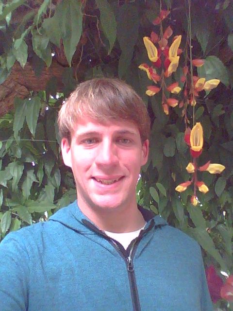
Yesterday March 8th was my and my brothers (triplets) 23rd birthday and when I first stared my blog I used to post a little about myself every year, but I have not done that in awhile. I'd like to take this time to talk about myself and things that have accomplished that I didn't have to time when it occurred, but first a little about myself. My name is Derek McKay, I am a triplet I have brothers Bryan and Chase who share a birthday with me and I have an additional older brother Aric as well. We all grew up in the town of Clayton in Northwest Wisconsin with my parents Wendy and Don, it was there that I discovered my passion for weather and gardening as well as gaining a sense for my community. My interests in weather sparked from watching storms from my hometown house, one in particular that I remember is the 2006 strait line wind event of MN/WI/MI. I began filming and photographing storms as well as forecasting for the area around my hometown. I did my first stormchase at 18 with my dad which was a 7 mile journey from Clayton,WI to Clear Lake,WI. My first major chase was with long time storm chasing friend Dave W. from Isanti,MN and others where we went to Kansas City,MO where I saw my first significant weather event. What my family remembers most about my past in terms of my weather passion is running from the computer to check radar and then running to the door to see the storm front coming in.
 photo 102_7996.jpg
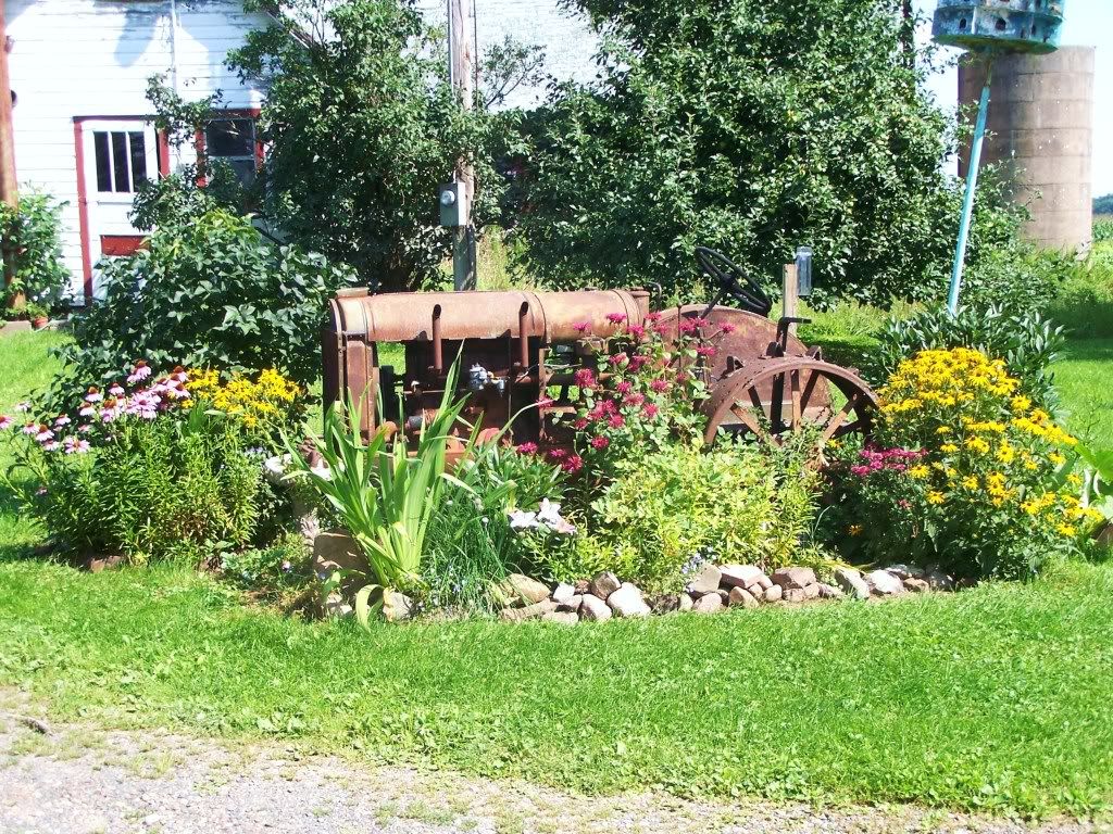
 My original garden-Clayton, WI

My passion for horticulture began when I got a plant ( Achillea ) from my mom. I planted next to an old tractor in at the house I grew up in and a passion for horticulture was born. It was that as well as the influence of my nearby aunts, Carol and Ruthie's beautiful gardens who lived nearby that really sparked my interest for gardening. Living in wooded hills of Northwest Wisconsin had its advantages because there were many species of trees,shrubs and flowers and while growing up I would discover a new species and research it extensively one by one. This really helped when it came to college. I knew I had 2 passions, weather and horticulture but when it came time to enroll in college I had to pick one, However I knew that I would always have weather as a passion and weather and horticulture paired together very well!
 photo 37ae356c-3ccf-4648-8fd8-14c7256d01fb_zps0bdc4930.jpg


With the support of my aunts and immediately family and after looking and many degrees and colleges decided horticulture was going to be my career. After leaving my now fully landscaped hometown home I enrolled and went to Rochester Community and Technical College in Rochester,MN, which was also the start of my move southward. It was in Rochester that I discovered I really liked people and volunteering because my aunt Candie who I stayed with in college was very involved in volunteering. While living there I got the opportunity to landscape her yard which helped my new found skills in college develop. This leads me to something I never got the chance discuss on my blog because I became busy with starting a career.

 photo 1375176_10151902272938069_1096443418_n_zps71cb3688.jpg
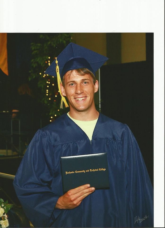
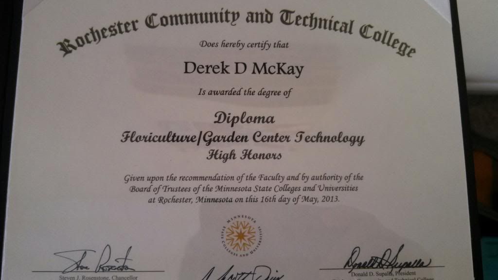
After taking many great classes, including Meteorology as an extra class that tied in very well with my interests, in May 2013 I graduated with a degree in Horticulture and I had the honor of receiving high honors and a GPA of 3.8-4.0 which confirmed to me I was taking on a career I had a lot of knowledge in. After college I starting my next journey and moved to Iowa when I was offered a job at a garden center, first in Cedar Rapids for the 2013 season, and now Des Moines for the 2014 season. I've also became involved with volunteering for such organizations as Trees Forever and City park and rec departments, and soon to be the Des Moines Botanical Garden here in Des Moines.

As for my future career goal, it is simply, I'd like to get a year round job in horticulture working as a consultant or in a public garden and eventual home ownership.

As for anyone interested in hearing the career paths of my brothers, Bryan is perusing, Cosmetology,  Chase Medical, and Aric Law Enforcement. Which says how even though we are triplets we have very diverse personalities.

This brings me to my next topic, I'd like to recognize this is my blogs 6th year running! In 2008 a friend of mine talked me into a blog which lead me to start the blog I still have today. I first ran it for weather in Northwest Wisconsin, then gardening as well and now I run this blog for both. Long time viewers from the beginning until now have had the opportunity to watch both my passions develop into what they are now.

As for the future of my blog, I will continue to run it, and I actually have exciting times ahead for it. I have become involved with a weather group called Iowa Weather Network in which I will be doing some forecasting as well as publishing posts about horticulture. I will have more information and links on this in the coming days.

Thanks for taking the time to get to know the person behind the blog!

Derek McKay.

Spring growth update # 1 1st flower of the season blooms today! High temperatures 50- to near 60 reported!

 photo IMG_6840_zps1a529910.jpg
Early spring scene March 9th 2014

Today was a beautiful day across central and southern Iowa. It features sunshine and warm spring-like temperatures in the 50s to just about 60. Sun was plentiful and warm with only occasionally filtered cloudiness that moved in from time to time. People were outside enjoying the weather filling and just being outside after a long, cold winter.

 photo IMG_6838_zps531db5ba.jpg
 Snowdrop in bloom March 9th 2014

The 1st flower of the 2014 season is now in bloom and goes to a Snowdrop, one of the earliest flowers to bloom. This is my 1st year with these and they are very small only 1" depending on the flower. There is a light fragrance to them as well. They also sprout and flower very fast as the flowerbud appears at the same time as the leaves.
 photo IMG_6839_zps9943ef4a.jpg

Daffodils March 9th 2014

There are also Daffodils and now Hyacinths sprouting as well. All of the stuff mentioned above is along the southern foundation of my house which is a warm spot, other areas of the lawn, the ground is still frozen.

Highs today:

Des Moines-Fairmount Park 59.F
Des Moines Airport 58.F
 Indianola 58.F
Ankeny 57.F
 Pella 55.F
 Knoxville 55.F
Winterset 55.F
Boone 52.F
Ames 48.F
Marshalltown 48.F

Thursday, March 6, 2014

Snowcover melting this week will lead to incresing temperatures. Spring will feel like it is arriving.

 photo ResizedImage_1394162334452_zps483c9aee.jpg
Beautiful sunny afternoon March 6th Des Moines Metro

A look across the area has many people noticing the snowcover is retreating once again across the area. Especially from Des Moines South. I have even seen a difference in snowcover between the North part of Des Moines and the southside of the metro. Snowcover really decreases temperatures because of the reflective nature of the white snow. Exposed Brown grass absorbs light and warms the atmosphere. The difference is usually 10+ degrees when you rid snowcover. Example would be today. Ames which has more snowcover had a high of 34.F today while Des Moines, which has a patchy snowcover now had a high of 39.F.
 photo localmapsnowcover_zpsceea5cda.png


Regional snowcover

The current snowcover across the Midwest goes from northern Missouri all the way up to the Canadian boarder. In Iowa, Nebraska, Missouri, and Illinois the snowcover is light or patchy. Northeast Iowa, Southern Minnesota and Wisconsin has a very thick snowcover. Warmer temperatures this week will melt the snowcover and he snowcover line will be moving northward this week. Mondays highs will range from near 70.F in Kansas City to near 60 here in Des Moines to the middle 40s up towards Rochester,MN I suspect most of Iowa will be snow free accept the North/East 1/3rd

Here in the local area we will go completely snow free by the middle of next week and Spring will really feel like its has started. The entire snowcover will melt across the entire area. I will be watching my garden closely for the 1st official Spring flower, which could bloom next week!

Highs for the area will be in the low to mid 40s Friday, around 33.F Saturday then up to near 50 on Sunday! Monday highs will peak in the upper 50s and I have a feeling some areas will hit 60, especially Des Moines Proper.  Next week highs will remain in the upper 30s to middle 40s each day. Get ready for a very Spring-Like week!

Monday, March 3, 2014

Warmth is coming, but we have some snow chances to get through first. Could be looking at mid to upper 50s come Monday, however it does not last long term.

 photo 303-Copy-Copy15-Copy_zpsb43f1e6c.png
Regional Weather View

The jet stream will be making a move this week in a better direction which will bring much needed warmth into the region by the weekend into early next week, but before that happens a disturbance or two will pass along it. Areas of Northern Nebraska, Iowa, Illinois, South Dakota, Minnesota and Wisconsin will see a disturbance along the warm front that will bring some minor accumulations to those areas on Tuesday night. Thursday will be the main start of the warming trend for most areas. High temperatures will warm into the 30s, 40s and 50s region wide and stay there for several days. Snow will be melting across much of the Midwest. By Monday many areas from Southern Iowa North will see 40s, and from Southern Iowa South will be seeing 50s and 60s.
 photo newlocalmap-Copy_zps7bdf67f7.png


Local View

For my first local forecast I am proud to be saying there is significant hope for warmth for our area, but as mentioned above we will have some snow to get through first. Tuesday and Tuesday night as a warm front pushes its warm into our area, snow will develop. It will be on the minor side with 1-2" with possibly locally up to 3-4" the likelyhood for totals. Highs will already be much warmer in the upper 20s by tomorrow. Wednesday will be cloudy to partly sunny with highs in the upper 20s to the lower 30s, with lows staying in the mid 10s. Thursday will finally be the day that warmer weather will really begin to move in. Highs will be near 40 with lows near 30 under partly sunny skies. Friday there will be a cold front pushing through bringing a cooler shot of air for the weekend. It will be cloudy with maybe a sprinkle or two as that front goes through with highs in the lower 40s and lows cooling to the low 20s. It will be dry for the weekend into the start of next week, Saturday will be partly sunny with highs in the lower to low to mid 30s and lows in the mid to upper 10s. Sunday will be much warmer with sunshine and highs in the upper 30s to as warm as the mid 40s depending on how much snowcover still remains. Monday will be the centerpiece to the warm up with highs warming to the mid to upper 50s. Whatever snowcover is still on the ground will melt off again.

Tuesday, Light snows developing in the evening. Lows in the mid 10s. Accumulations 1-3"

Wednesday, Cloudy skies with light winds. Highs in the upper 20s to the lower 30s. Wednesday night, Cloudy with lows in the upper 10s to lower 20s.

Thursday, Some Clearing, Partly sunny with highs in the upper 30s to lower 40s. Thursday Night, Partly Cloudy with lows in the upper 20s

Friday, Cloudy skies with highs in the upper 30s to lower 40s. A sprinkle or flurries are possible. Friday Night, Partly cloudy with lows in the middle 20s.

Saturday, Cloudy skies with some clearing. Highs in the upper 20s to lower 30s. Saturday night, Partly Cloudy with lows in the mid 10s.

Sunday, Sunny and Nice! Warmer, Southerly breezes with lows in the upper 30s ranging to the middle 40s. Sunday night, Partly Cloudy with lows in the upper 20s to lower 30s.

Monday, Beautiful, Southerly breezes with sunny skies. Highs in the mid 50s ranging to the upper 50s. Monday Night, Clear skies with lows in the upper 30s.


Looking Ahead

Unfortunateally this warm up we see will not last, but the good news is I do not see anything nearly as cold as it was the past couple days either. We might be able to squeeze 1 more 40-50 degree day Tuesday before a cold front passes through. Wednesday the 12th looks sunny with highs in the upper 20s to lower 30s. Thursday the 13th through Monday the 17th the weather will range from being in the 30s to the lower 40s with the jet stream to our south once again, but from time to time meandering north or overhead, during which times it will be warmer. There will be a chance of snow or two with this as well. It will overall be cool for March standards through that time. Then towards the middle of the month with the jet stream staying just south of us around the 18th and 19th could bring some chances for wet snow with the model actually trying to show a wet-type snowstorm over northern Missouri and Southern Iowa, but there is a chance rain could mix in. Through the entire model run with the acceptation of early in the run the jet stream is nearly overhead or south which indicates a cooler then normal pattern. However like I say I do not seen Significant cold like we've been dealing with so that will make it seem better.