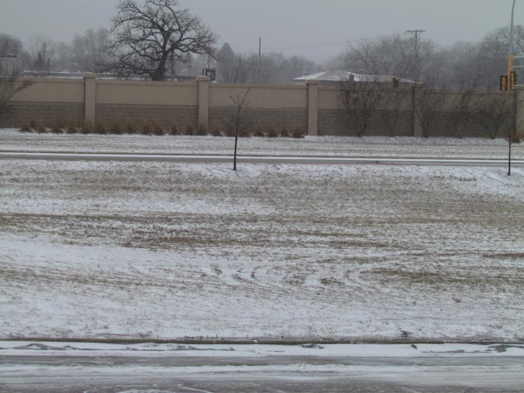
Lack of snowcover January 29th 2013
After Sundays ice storm and the 2 other systems that effected us this week its turning out to be a very active week. The latest active weather is all a part of 2 weather systems that past through the past 3 days. Monday night one which surprised many local residents, including me produced thunderstorms Monday Night and early Tuesday Morning. Then a second storm system which was a part of the same system that brought a large swath of heavy rain and severe storms to parts southern plain states brought us snow and cooler temperatures and a back to reality slap of cold air that were in January.
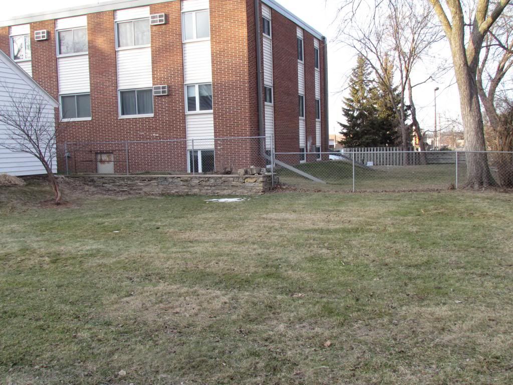
Interesting Note: Before the snow hit though the entire area was snow free for most of this month and even now snowcover is poor. This is the 2nd winter in a row with a poor snowcover in the month of January
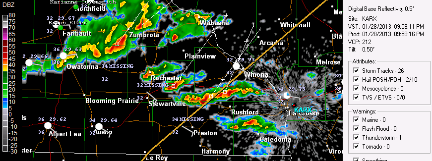
Radar shot of the cells that moved through January 28th and 29th
There were 2 rounds of thunderstorms one Monday Night and the other early Tuesday Morning many were surprising woken up by full fledged January thunderstorms, complete with thunder, lightning and heavy downpours! Many including me were not expecting it at all. In fact I was so not expecting it that getting ready for bed when I heard heavy rain on the roof and I did not remember what that sounded like, then when I heard thunder I was very surprised. A warm front moving up through Iowa sparked thunderstorms near the Minnesota boarder from there they moved northeast and brought heavy downpours, hail, thunder and lightning. Rainfall amounts ranged from 0.41" at Cannon Falls on the high end to 0.14 at Dodge Center and 0.22" here at my station in West Downtown Rochester. I still to this moment and surprised we got thunderstorms in the month of January its un believable and is absolutely unheard of to me but I could not find any historical information on just how rare January thunderstorms are, everyone I've talked to said it is usual. Even more surprising the temperature at my location was 33.F at the time the thunderstorms occurred. The temperature warmed to 37.F at about 1am.
Snowfall January 30th 2013
If I had to some up weather this winter so far it would be extremely changeable. We went from thunderstorms on Tuesday to snow on Wednesday.The low pressure system mentioned above that moved through the plain states moved northeast through Northeast Illinois. This put the very west edge of the swath of snow from a winter into our area. It was mostly light in nature and the entire area had minor accumulations occur area wide but it ranged from a trace in the west and north to 3" in the east. Here in Rochester it was 0.50" The bulk of this snow occurred in Southern Wisconsin, where 5-8" of snow fell. Like with all storm systems this time of year cold air was also brought in as well and strong northwest winds 35 to 40MPH. Temperatures went from the 30s on Tuesday night to below zero Wednesday Night.
Snowfall Reports
Winona 3.0"
West Downtown Rochester-My Station 0.50"
Dodge Center Trace
Red Wing Trace


Iowa Weather Network Warnings Map

Winter Weather Advisory
Wednesday, January 30, 2013
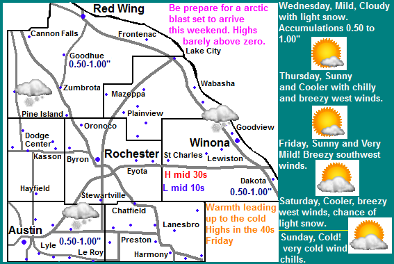
Tuesday, January 29, 2013
Winter Storm to bring a wide range in accumulating snows late tonight and Wednesday from 6" in the far east to little to no snow in the west and north. Arctic airmass arrives by Wednesday with single digits highs on Thursday.
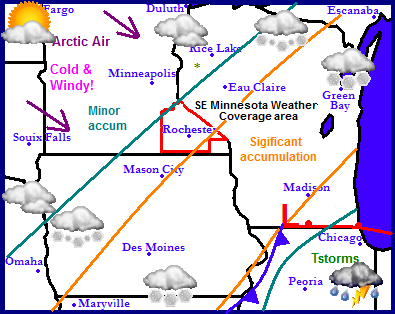
Regional Weather View.
It is turning out to be an active week in the Upper Midwest. Something I have not had to say in a long time. Attention is turned to our next weather producer which will spread thunderstorms across Illinois tonight, and significant snow accumulations to parts of Iowa, Far southeast Minnesota and parts of Wisconsin. A cold arctic airmass is waiting to move in behind this storm on strong northwest winds. The entire region will be plunged into this aissmass as the low moves away. The cool airmass will also keep things fairly dry. Temperatures will begin to moderate though the weekend.
Local and Metro views.
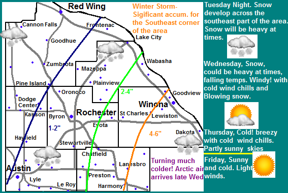
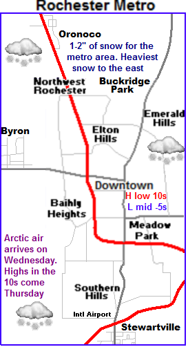 Winter storm for eastern parts of the area.
Parts of our area will be dealing with a winter storm, but because of the way this storm is shaped only the eastern parts will have this take place. Late tonight as a low pressure system moves from Missouri to Illinois snow will spread northeast through Iowa and into Southeastern Minnesota. A cold front will also sweep in from the northwest. The far western extend of the system will effect our area. Eastern Fillmore and Winona counties will see the heaviest and brunt of the accumulating snows Winona, Harmony, Lanesbro are just a few of the coummunties which stand the best chance at seeing winter storm value accumulations. There will be a sharp cut off, Further west 2-4" are possible including Preston, St Charles and Wabasha. West of here 1-2" are possible effecting Rochester, Austin and Lake City. North and west of here will just see flurries. Blowing snow and free falling temperatures will be a problem as winds gusting up to 40MPH at times bring in an arctic airmass from the northwest. Temperatures will fall into the single digits late Wednesday and below zero Wednesday Night.
Brunt of arctic airmass in place by Thursday.
For Thursday the brunt of the arctic airmass will be in place. It will also be breezy with cold wind chills making it feel colder. Highs will be only in the single digits above zero, with lows possibly falling to their coldest levels of the season so far with a fresh snowcover lows may fall to the 10s below zero. Friday will be sunny and cold but slighlty warmer then Thursday. It will also not be as breezy. Highs will be in the upper single digits, with lows in the single digits above zero as clouds increase Friday night. Saturday and Sunday temperatures will moderate to the 20s and 30s with lows in the 10s. There is a small chance for light snows on Saturday but the chance is low at this time.
Wednesday, Snow likely, heavy at times east. Much Colder! and Windy with winds gusting to 40MPH. Snow accumulations 1-4" Central areas with 4-6" in the East part of the area. Wednesday Night, Cold, Windy with cold wind chills. Lows in the mid single digits below zero. Winds gusting to 30MPH
Thursday, Cold! Breezy with cold wind chills, Arctic Sunshine, highs in the low to mid single digits. Thursday Night, Cold! Clear skies, lows in the low to mid single digits below zero.
Friday, Cold! Sunny skies with highs in the mid to upper single digits above zero. Friday Night, Increasing Clouds and a chance of flurries, Chilly with lows in the single digits.
Saturday, Partly Sunny and warmer. A chance for flurries. Highs in the mid 20s. Saturday Night Cloudy, lows in the mid to upper 10s.
Sunday, Pleasant, Sunny, light winds. Highs in the low to mid 30s. Sunday Night, Partly Cloudy, lows in the upper 10s to lower 20s.
Looking Ahead
Monday a weak clipper system passes to the north, not bringing us any additional snow. Tuesday a mild dry airmass moves in bringing pleasant to warm temperatures and dry conditions through Thursday. There is a chance we may see 40s for highs some days. Friday the 8th a cold front passes through dry and brings in cold air for the weekend of the Sunday the 10th of February. Slightly milder air arrives for the start of the week of the 12th. Then things turn more active once again. Tuesday the 13th of February a low pressure system moves form Kansas to Illinois bringing us a snowstorm here in Minnesota and very cold and drier air after the passing of this storm. More as on this later.
Monday, January 28, 2013
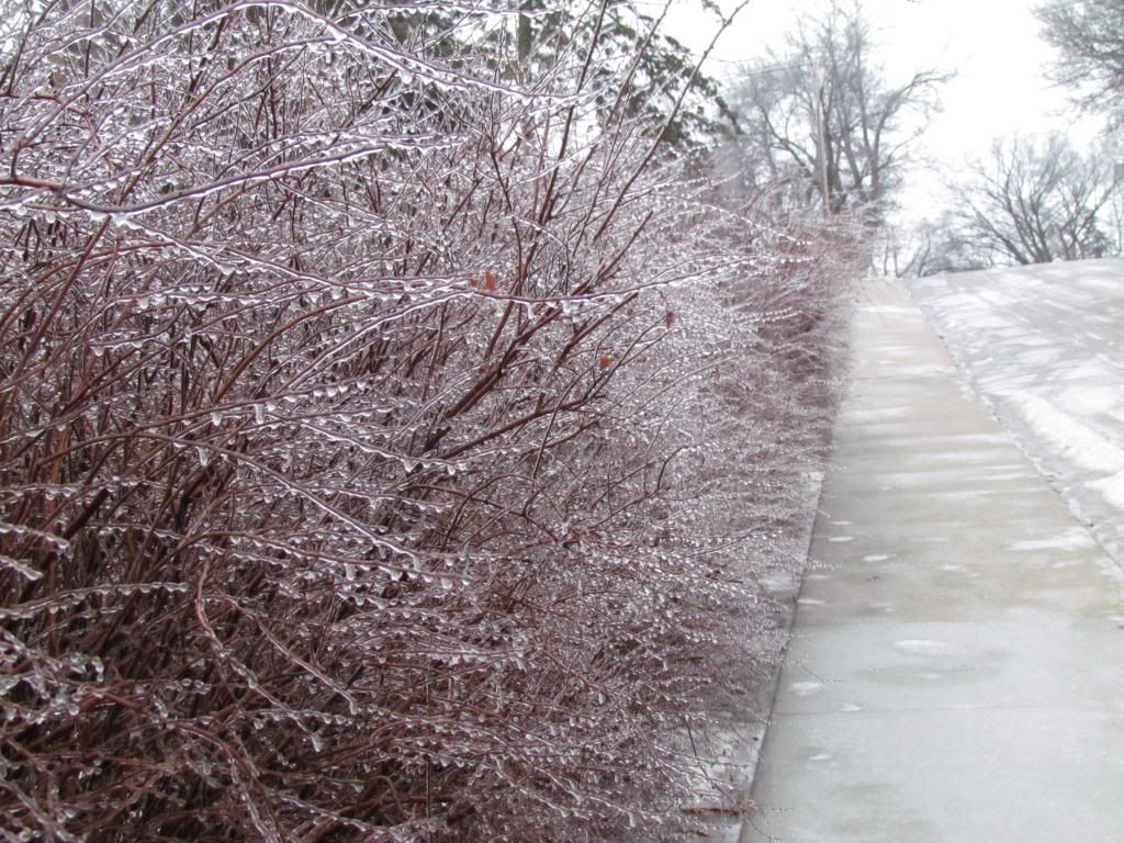
January 27th ice storm. 0.25-0.30 of inch of ice accumulation caused major travel impacts and damage to some trees and powerlines.
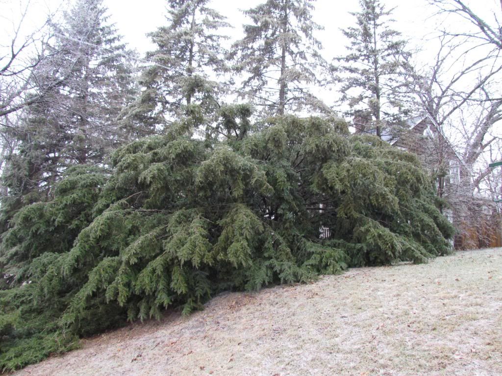
Branches weighed down by ice on an evergreen.
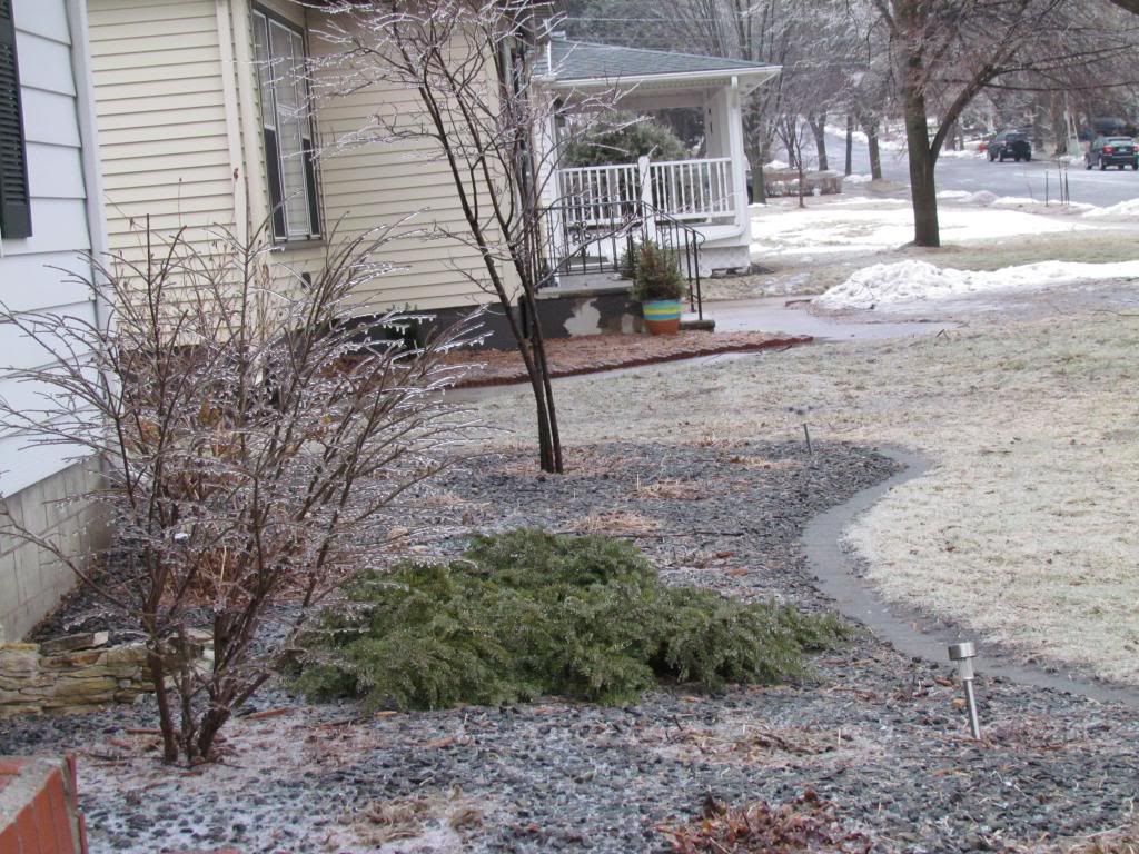
Sundays, a low pressure system moved across the region, spreading a wave of light to moderate precipitation through the entire area Sunday Morning into the early afternoon hours before tapering down to drizzle for the evening and overnight hours. Temperatures ranged from 30 to 32.F and most of the precipitation type was freezing rain, however the far northern parts of the area Cannon Falls and Red Wing areas had sleet and slow mixing in. About 1" of snow was seen in this area with some ice accumulation. Future south 0.25-0.30" of rain which quickly froze to roads and sidewalks and trees because of how cold it has been lately, it became a full fledged ice storm in this region. This ice accumulation on sidewalks and roads caused significant travel impacts and delays several roads, even all of the areas major roads were effected. Even though the ice ended at least 10 hours before Monday cool temperatures allowed for ice to remain on roads shutting down many area schools on Monday morning.
Ice on landscaping in the front yard January 27th.
Here in Rochester freezing rain started at 9am and continued until about 2pm. The precipitation type was nearly all freezing rain with bouts of some sleet. Freezing rain was moderate at times which was it was a new experience for me to see freezing rain at a heavier rate then drizzle.
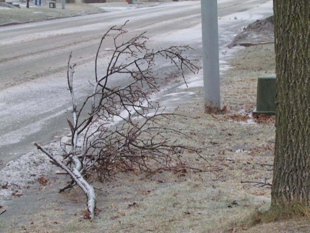
Fallen tree branch January 27th
Impacts around Rochester and everywhere else were majorly centered around horrible travel conditions. Many accidents were reported around the metro and over 650 accidents were reported in Southern Minnesota. Main roads were kept up fairly well but even travel on those was slowed. Traffic on highway 52, the major 6 lane freeway through the city was slowed down significantly. On Interstate 90 there were reports of several accidents and 100s of cars pulled over to the side of the roads waiting out the slippery conditions. Side roads were nearly impossible to travel on because of ice. Mower County reported many accidents county wide. It came to a point where The Minnesota Department of Transportation at one pointed advised no travel on all of our areas major roads including Highway 14, Highway 52, Highway 63, Highway 61, and Interstate 90. There was minor damage to power lines and trees with a few loosing some limbs in the ice. Branches were reported down in Kasson as well. There were reports of power lines coming down in the city of Austin causing problems with outages and blocking some roadways. Monday Morning all of the public schools were closed because of continued icy roads.
Ice January 27th
The photo above shows this event as it happened fairly well. Ice accumulation amounts ranged from a quarter of an inch to 3 tenths of an inch. This made it difficult to get out for photos because of ice and people had to walk slowly or not on the sidewalk at all to avoid slipping. Northern Goodhue County precipitation began to turn to sleet and snow. around 1" of snow was reported n Cannon Falls and Red Wing. It is interesting to note that future north outside of the coverage area into central Minnesota and Northern Wisconsin, rain turned to all snow, accumulations were 3-5" up through central Minnesota and my hometown area. Little icing was seen here.
January 27th event and Ice Storm Reports
Red Wing 1" snow
Austin- Multiple accidents on I-90
Austin-Power lines down
Austin Freezing Rain-0.25"
Kasson-Tree limbs down ice covered roads
Rochester-Traffic significantly slowed on highway 52, many accidents around the city.
Rochester-A few limbs down
Rochester Freezing Rain-0.25"
Winona mixture of snow/sleet numerous accidents reported on I-90
Winona Freezing Rain 0.10"
Stewartville sleet and freezing rain
Spring Valley-Freezing Rain 0.10"
Harmoney Freezing Rain -.25"
Wabasha-Freezing Rain 0.10"
West Concord Ice coating the road and trees
Dover Freezing Rain
Grand Meadow Freezing Rain
Saturday, January 26, 2013
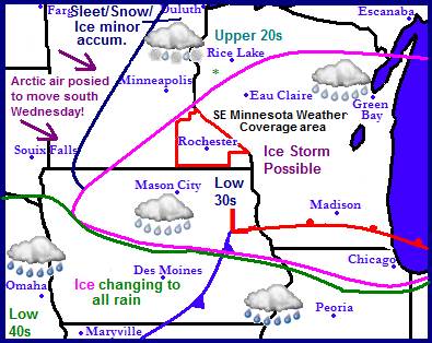
Snowstorm possible in the southeast tonight. Arctic air arrives Wednesday and Thursday. Updated X1
Regional Weather View
Tuesday& Wednesday another weather system moving up through Iowa and Illinois will spread heavy snow across parts of Iowa, Southeastern Minnesota and Central Wisconsin, this will be on the leading edge of an arctic airmass which will bring in sharply colder temperatures for Thursday.
Local weather view.
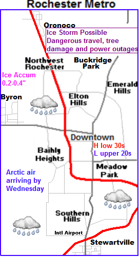 Note: I did make an attempt to update this forecast for the upcoming storm, but I will re update this and change the maps this afternoon when data becomes more consistant.
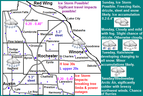
Snowstorm possible tonight then arctic air Thursday
Our next chance of rain and snow arrives Tuesday ahead of a arctic airmass. Right now snow will develop Tuesday as a low pressure system produced a very narrow corridor of heavy snow in the far east. Accumulations will be 4-6" in far eastern parts of Winona and Fillmore counties but it will be very isolated. 0.50-1.00" is possible as far west as Rochester, but west of here little to no snow accumulation. More on this later today. Wednesday will be cloudy, cold and windy. Highs will only be in the 10s with northwest winds gusting to 25MPH leading to cold wind chills. Expect lows to be below zero Wednesday Night and highs only in the single digits on Thursday
Tuesday, Drizzle changing to snow, heavy at times in the southeastern part of the area. Snow accumulations 4-6" in the far southeast. 0.50-1.00" possible from Rochester to the east. Highs in the middle 30s. Tuesday Night, Snow, Colder with a chance of light snow. Lows in the middle 10s.
Wednesday, Cold, windy with cold wind chills. Winds gusting to 35MPH Cloudy with a chance of light snow, then clearing skies. Highs in the middle 10s. Little to no snow accumulation. Wednesday Night, Clear skies and cold. Lows in the middle single digits below zero.
Looking Ahead
Looking ahead we have another shot of a significant arctic airmass which will put our highs in the single digits and lows well below zero for Thursday and Friday of this week. Saturday of next weekend a weak clipper slides southeast bringing a chance for light snows. Looking towards Sunday and Monday the 3rd and 4th things warm up nicely and remain fairly dry. Things warm up even more as we begin to approach the 8th of February. We may have several days with highs in the 30s and 40s if we have continued lack of snowcover. However towards the 11th of Febuary a strong arctic airmass building to our northwest slides southeast engulfing us in an arctic airmass and the type of weather pattern that is cold and dry with occasional systems that produce light snows every few days.
Tuesday& Wednesday another weather system moving up through Iowa and Illinois will spread heavy snow across parts of Iowa, Southeastern Minnesota and Central Wisconsin, this will be on the leading edge of an arctic airmass which will bring in sharply colder temperatures for Thursday.
Local weather view.
 Note: I did make an attempt to update this forecast for the upcoming storm, but I will re update this and change the maps this afternoon when data becomes more consistant.
 Snowstorm possible tonight then arctic air Thursday
Our next chance of rain and snow arrives Tuesday ahead of a arctic airmass. Right now snow will develop Tuesday as a low pressure system produced a very narrow corridor of heavy snow in the far east. Accumulations will be 4-6" in far eastern parts of Winona and Fillmore counties but it will be very isolated. 0.50-1.00" is possible as far west as Rochester, but west of here little to no snow accumulation. More on this later today. Wednesday will be cloudy, cold and windy. Highs will only be in the 10s with northwest winds gusting to 25MPH leading to cold wind chills. Expect lows to be below zero Wednesday Night and highs only in the single digits on Thursday
Tuesday, Drizzle changing to snow, heavy at times in the southeastern part of the area. Snow accumulations 4-6" in the far southeast. 0.50-1.00" possible from Rochester to the east. Highs in the middle 30s. Tuesday Night, Snow, Colder with a chance of light snow. Lows in the middle 10s.
Wednesday, Cold, windy with cold wind chills. Winds gusting to 35MPH Cloudy with a chance of light snow, then clearing skies. Highs in the middle 10s. Little to no snow accumulation. Wednesday Night, Clear skies and cold. Lows in the middle single digits below zero.
Looking Ahead
Looking ahead we have another shot of a significant arctic airmass which will put our highs in the single digits and lows well below zero for Thursday and Friday of this week. Saturday of next weekend a weak clipper slides southeast bringing a chance for light snows. Looking towards Sunday and Monday the 3rd and 4th things warm up nicely and remain fairly dry. Things warm up even more as we begin to approach the 8th of February. We may have several days with highs in the 30s and 40s if we have continued lack of snowcover. However towards the 11th of Febuary a strong arctic airmass building to our northwest slides southeast engulfing us in an arctic airmass and the type of weather pattern that is cold and dry with occasional systems that produce light snows every few days.
Thursday, January 24, 2013
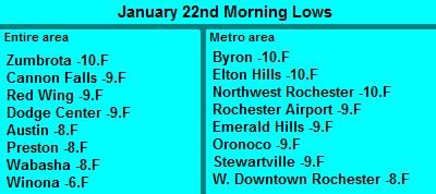
January 22nd morning lows
Lows Monday Morning.
The area was fully immersed in an arctic on Monday. The cold air was driven southeast by a very strong cold front which passed through on this past Saturday. It took 24 hours before the worst of the effects of the cold arrived from the northwest, but when it arrived it was very cold. Highs on Monday were only in the single digits just barely above zero. Some areas remained at zero or below. Unfortunately there was no snow proceeding the airmass so the ground remained snowless through the entire stretch of cold, which is rather odd. I don't think I've ever witnessed winter cold with no snowcover on the ground. The coldest temperature reported was Zumbrota and Byron at -10.F. These temperatures would have been much colder had there been snow on the ground. Areas of far Northern Minnesota had their coldest weather this morning and it was very brutal in those areas. To compare to our area International,MN had a low of -36.F below zero! With the coldest low in the state being -42.F below zero at Embarras,MN Our temperatures were rather warm compared to that!
The area was fully immersed in an arctic on Monday. The cold air was driven southeast by a very strong cold front which passed through on this past Saturday. It took 24 hours before the worst of the effects of the cold arrived from the northwest, but when it arrived it was very cold. Highs on Monday were only in the single digits just barely above zero. Some areas remained at zero or below. Unfortunately there was no snow proceeding the airmass so the ground remained snowless through the entire stretch of cold, which is rather odd. I don't think I've ever witnessed winter cold with no snowcover on the ground. The coldest temperature reported was Zumbrota and Byron at -10.F. These temperatures would have been much colder had there been snow on the ground. Areas of far Northern Minnesota had their coldest weather this morning and it was very brutal in those areas. To compare to our area International,MN had a low of -36.F below zero! With the coldest low in the state being -42.F below zero at Embarras,MN Our temperatures were rather warm compared to that!
Sunday, January 20, 2013
Arctic airmass made its presence known across Southeast Minnesota with powerful 50-60MPH wind gusts and a 25-30 degree temperature dr
Warm January day, January 18th 2013
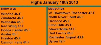
This weekend was definitely had two totally different tales to tell. Friday and Saturday was sunny and mild. Fridays highs were in the mid to upper 40s and Saturdays highs were in the lower 40s. The sun was shining, the sky was bright, winds were light and it felt like the feel of spring in the air. This was the calm before the arctic airmass blew through the area.
Highs Friday January 18th
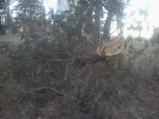
Large tree branch down St Marys Park
Arctic Cold Front
As beautiful as it was everyone knew a strong arctic cold front was about to plow through the area, and it definitely made its presence s known. After a high of 43.F here at my station Saturday early afternoon, winds switched northwest abruptly ending out feed of warm air from the south. The winds turned very strong and just downright powerful through the late afternoon hours into the evening hours gusting 50 to 60MPH. A very impressive wind gust of 66MPH was recorded at the Downtown Rochester weather station, but this number may have been increased by the fact that this weather station is 8 stories off the ground, but even the Rochester Airport recorded a wind gust of 55MPH, and every station throughout the area reported widespread 44 to 55MPH gusts. The wind was definitely the major player with this front, it was usually strong and caused havoc blowing things around, and even causing some minor tree damage to mostly evergreens. Many residents felt the winds. There were quite a few things to pick up the next day. The worst of the winds lasted about 5 hours. The other thing the winds did was draw in very cold air from the northwest. By 5pm temperatures had cooled down to the middle teens and it felt like quite a shock. By morning Sunday temperatures were 25 to 35 degrees colder then they were on Saturday, as seen below. What was odd about this arctic airmass is it did not come with any snow, so even though its cold out now, we still have no snow on the ground, which I have to say is quite an odd look with an arctic airmass in place.
Reported Wind Gusts + Highs Saturday / Lows Sunday Morning
West Downtown Rochester 66MPH 43.F / 3.F
Rochester Airport 55MPH 41.F / 1.F
Dodge Center 53MPH 41.F / 1.F
Preston 52MPH 42.F / 1.F
Cannon Falls 51MPH 41.F / 2.F
Winona 46MPH 43.F / 5.F
Austin 45MPH 43.F / -0.F
Red Wing 44MPH 41.F /1.F
Saturday, January 19, 2013
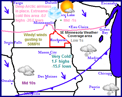
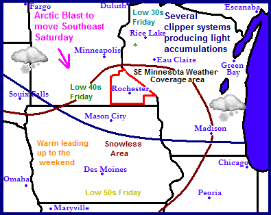
Arctic cold front passes through today, very gusty winds up to 50MPH with a chance of light snow as it passes. Very cold air in place Sunday-Tuesday highs in the single digits and lows falling well below zero. Dangerous wind chills around -25.F possible. Not warming up until Wednesday
Regional Weather View
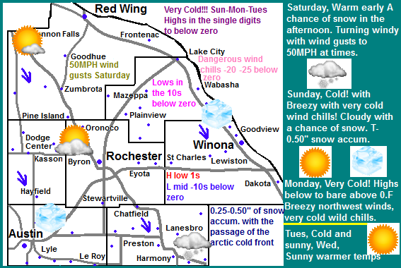
Very cold temperatures are making their way southeastward today as an arctic cold front blows through the region as causes some issues. The arrival of this cold air will cause problems mainly in the form of strong gusty wind gusts to 50MPH across a wide part of the region. This front will have limited moisture so Very little snowfall will be seen with this as it passes through But existing snowcover on the ground will blow around in areas across Central and Northern Minnesota, causing problems with blowing snow. Extremely cold temperatures will pour in behind this front. In North Dakota, Northern Minnesota and Wisconsin highs will be below zero. With lows falling in the pink shaded area in the 20s below zero range. It will not be much warmer across the rest of the area highs will range from the lower single digits in Southern Minnesota to the middle 10s in Southern Iowa. Temperatures will moderate starting Wednesday.
Local and Metro views
Note: This forecast is an update to the previous one.
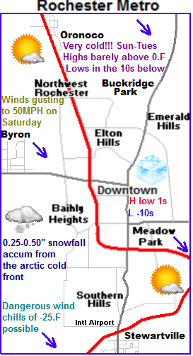 Passing of an arctic cold front will lead to light snow and 50MPH winds today
A very strong cold front will sweep across the region today and usher in significantly colder temperatures which will feel very cold to many due to the warmth we've been experiencing lately. Highs will peak out in the lower 40s early in the day Saturday, then by the afternoon the arctic front will be on our doorstep, a quick burst of snow will push through with a quick accumulation of a Trace to a 0.50" Winds will pick up drastically and become a problem with Winds will turn northwest and become strong 35MPH gusting to 50MPH at times Which is likely to cause some problems and possibly even some blowing snow, but will be highly dependent on how much we receive with the front. The winds will continue at this strength through the evening ushering in significant colder temperatures.
Arctic Airmass in place Sunday-Tuesday Very cold temperatures, dangerous wind chills
Sunday will be significantly colder then Saturday by as much as 35 degrees colder. Which is why I have blue ice cubes on the maps to represent how we all may feel by the time Sunday comes around! Temperatures during this outbreak will be slightly moderated by the fact we have no snowcover. We can expect highs in the single digits but breezy northwest winds to 30MPH will make if feel much colder as wind chills will be lowered to dangerous 20 -25.F levels. Early Sunday will have a chance of some wind driven light snow. Accumulations will be light. Sunday Night will be mostly cloudy and cold, with lows in the lower 10s below zero. Wind chills will be just as dangerous as they will during the day. Monday will be the coldest day. It will be very cold under arctic sunshine and breezy northwest winds bringing about very cold wind chills, Highs will only be in the lower single digits, and some areas may not in fact get above zero! and lows Monday Night will be in the mid to upper 10s below zero It is important to note these will be the coldest temperatures our area has seen in a least 2 years, and it will be complicated by the fact that wind chills will be in the -20 below zero range, so be prepared. Tuesday will not be much warmer, but at least winds will slacken, highs will be in the lower single digits above zero, with arctic sunshine. Lows will be in the mid single digit below zero.
Slightly warming temperatures by Wednesday
Wednesday it finally begins to warm up to tolerable levels, With increasing clouds reveling a cloudy Wednesday, highs will rise to the lower 10s and lows will fall to the single digits above zero. The areas next chance of snow will be Thursday.
Saturday, Mild, Partly sunny with highs in the lower 40s. Increasing clouds in the afternoon with a chance of snow. Accumulations Trace to half inch, Winds turning northwest and increasing to 35MPH with gusts to 50MPH. Saturday Night, Turning Cold, with dangerous wind chills, Windy, winds 35MPH gusting to 50MPH
Sunday, Cold! and breezy with dangerous wind chills around -20.F Mostly cloudy with a chance of light snow, accumulations Trace to a quarter inch. Highs in the lower single digits. Sunday Night, Very Cold! Clearing skies with lows in the lower to middle 10s below zero.
Monday, Very Cold!!! Arctic sunshine with breezy northwest winds and cold wind chills. Highs in the single digits above, to single digits below zero. Wind chills -10 to -15.F below. Monday Night, Very Cold!!! Lows in the mid to upper single digits below zero.
Tuesday, Cold! Arctic Sunshine with increasing clouds. Highs in the lower single digits. Tuesday Night, Mostly cloudy with lows in the mid to lower single digits below zero.
Wednesday, Warmer, Partly sunny with highs in the mid to upper 10s. Wednesday Night, Mostly Cloudy with lows in the mid to upper single digits above zero.
Looking Ahead
Thursday is our next chance of snow as an organizing system may bring us some snowfall, but it really doesn't look heavy just yet, maybe a couple inches at most. Cold air surges in behind this and gives us another breif shot of arctic air. Next weekend it warms but looks dry with more seasonable temperatures, with clouds and some sunshine. Monday the 28th a nice warm up moves in from the west bringing mild temperatures into the 30s. Tuesday the 29th a large system develops to our south over Oklahoma and brings a snowstorm to areas of the Midwest. The model does keep it to the east of our area with only the far western edge effecting us, but it will be one to watch and see if it stays in the model. After the passing of this storm it turns cold and drier once as we start out the month of February.
Very cold temperatures are making their way southeastward today as an arctic cold front blows through the region as causes some issues. The arrival of this cold air will cause problems mainly in the form of strong gusty wind gusts to 50MPH across a wide part of the region. This front will have limited moisture so Very little snowfall will be seen with this as it passes through But existing snowcover on the ground will blow around in areas across Central and Northern Minnesota, causing problems with blowing snow. Extremely cold temperatures will pour in behind this front. In North Dakota, Northern Minnesota and Wisconsin highs will be below zero. With lows falling in the pink shaded area in the 20s below zero range. It will not be much warmer across the rest of the area highs will range from the lower single digits in Southern Minnesota to the middle 10s in Southern Iowa. Temperatures will moderate starting Wednesday.
Local and Metro views
Note: This forecast is an update to the previous one.
 Passing of an arctic cold front will lead to light snow and 50MPH winds today
A very strong cold front will sweep across the region today and usher in significantly colder temperatures which will feel very cold to many due to the warmth we've been experiencing lately. Highs will peak out in the lower 40s early in the day Saturday, then by the afternoon the arctic front will be on our doorstep, a quick burst of snow will push through with a quick accumulation of a Trace to a 0.50" Winds will pick up drastically and become a problem with Winds will turn northwest and become strong 35MPH gusting to 50MPH at times Which is likely to cause some problems and possibly even some blowing snow, but will be highly dependent on how much we receive with the front. The winds will continue at this strength through the evening ushering in significant colder temperatures.
Arctic Airmass in place Sunday-Tuesday Very cold temperatures, dangerous wind chills
Sunday will be significantly colder then Saturday by as much as 35 degrees colder. Which is why I have blue ice cubes on the maps to represent how we all may feel by the time Sunday comes around! Temperatures during this outbreak will be slightly moderated by the fact we have no snowcover. We can expect highs in the single digits but breezy northwest winds to 30MPH will make if feel much colder as wind chills will be lowered to dangerous 20 -25.F levels. Early Sunday will have a chance of some wind driven light snow. Accumulations will be light. Sunday Night will be mostly cloudy and cold, with lows in the lower 10s below zero. Wind chills will be just as dangerous as they will during the day. Monday will be the coldest day. It will be very cold under arctic sunshine and breezy northwest winds bringing about very cold wind chills, Highs will only be in the lower single digits, and some areas may not in fact get above zero! and lows Monday Night will be in the mid to upper 10s below zero It is important to note these will be the coldest temperatures our area has seen in a least 2 years, and it will be complicated by the fact that wind chills will be in the -20 below zero range, so be prepared. Tuesday will not be much warmer, but at least winds will slacken, highs will be in the lower single digits above zero, with arctic sunshine. Lows will be in the mid single digit below zero.
Slightly warming temperatures by Wednesday
Wednesday it finally begins to warm up to tolerable levels, With increasing clouds reveling a cloudy Wednesday, highs will rise to the lower 10s and lows will fall to the single digits above zero. The areas next chance of snow will be Thursday.
Saturday, Mild, Partly sunny with highs in the lower 40s. Increasing clouds in the afternoon with a chance of snow. Accumulations Trace to half inch, Winds turning northwest and increasing to 35MPH with gusts to 50MPH. Saturday Night, Turning Cold, with dangerous wind chills, Windy, winds 35MPH gusting to 50MPH
Sunday, Cold! and breezy with dangerous wind chills around -20.F Mostly cloudy with a chance of light snow, accumulations Trace to a quarter inch. Highs in the lower single digits. Sunday Night, Very Cold! Clearing skies with lows in the lower to middle 10s below zero.
Monday, Very Cold!!! Arctic sunshine with breezy northwest winds and cold wind chills. Highs in the single digits above, to single digits below zero. Wind chills -10 to -15.F below. Monday Night, Very Cold!!! Lows in the mid to upper single digits below zero.
Tuesday, Cold! Arctic Sunshine with increasing clouds. Highs in the lower single digits. Tuesday Night, Mostly cloudy with lows in the mid to lower single digits below zero.
Wednesday, Warmer, Partly sunny with highs in the mid to upper 10s. Wednesday Night, Mostly Cloudy with lows in the mid to upper single digits above zero.
Looking Ahead
Thursday is our next chance of snow as an organizing system may bring us some snowfall, but it really doesn't look heavy just yet, maybe a couple inches at most. Cold air surges in behind this and gives us another breif shot of arctic air. Next weekend it warms but looks dry with more seasonable temperatures, with clouds and some sunshine. Monday the 28th a nice warm up moves in from the west bringing mild temperatures into the 30s. Tuesday the 29th a large system develops to our south over Oklahoma and brings a snowstorm to areas of the Midwest. The model does keep it to the east of our area with only the far western edge effecting us, but it will be one to watch and see if it stays in the model. After the passing of this storm it turns cold and drier once as we start out the month of February.
Wednesday, January 16, 2013
Ideas for keeping deer & rabbits out of the garden.
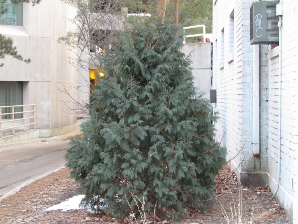
Arborvitae, Thuja occidentalis
Deer, Rabbits and other pests can be a huge problem in the garden in winter. I've heard news reports recently of homeowners having problems with deer and rabbits eating shrubs and causing lots of damage. Before we start with tips to help with the problem It's important to know why deer and rabbits would even want to eat the bushes in the first place. Deer cause damage by ripping branches off trees, but especially evergreens. Arborvitae are especially liked by deer. Ever see those bushes near woods like with what appear to be puff balls on top of a stick? Those are likely arborvitae branches that have been eaten by deer as far as they can reach causing that effect. Deer can also cause damage to trunks of young trees when male deer rub their antlers against the trunk scraping off bark. Rabbits are a bit different in the damage they cause but it is also from feeding. Rabbits chew on bark of young trees and thin barked trees and removing it and cutting off the cambium and phloem layers lie with in 2 inches below the bark. These layers are critical for trees and shrubs survival. If bark is removed completely around the young tree or shrub will die back to the point of injury and will have to regrow new shoots. If they have damaged a blooming shrub you've probably lost flowers for that year. If it is a tree they've damaged the tree can survive but it will be set back a few years, and will have to go through pruning programs to correct it from co dominate leaders. Also watch out if a fruit tree has been damaged, sometimes fruit trees are grafted and if the injury occurs below the graft, you will be left with the root stock that fruit tree was grafted onto which is more then likely produces un wanted fruit quility.
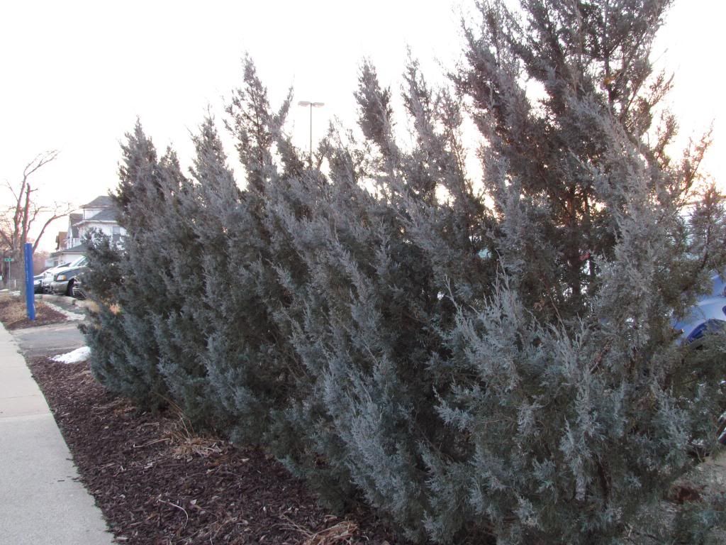
Wichita Blue Juniper, Juniperus scopulorum 'Wichita blue'
There are many products out there to repel deer and rabbits, and in many cases these do work, but you have to spray them on every time it rains, and also every few weeks to re new the scent. I think a product like this is great in the summer for a wanted plant, but for trees and shrubs it is difficult and timely. I believe there is only 3 real methods that will work to really protect trees and shrubs from injury. Complete Fencing off of the the tree or shrubs is a great full proof way to keep pests from munching on trees and shrubs, and it is especially easy for rabbits. I often just make a fence circle and that is enough. For deer it will require more extensive fencing and possibly electric fence. Another method to prevent damage from deer is pruning trees and shrubs in a way that takes off all small branches to the point that deer cannot reach it, of course this significantly alters the shape. My last an best way to keep pests from feeding is to not plant varities of shrubs that attack deer and rabbits! Plants like Apple trees and arborvitae attract these pests because they like to feed on them, but if a type of tree or shrub that is chosen that taste bad to deer, they will not be as attacked to it. Like instead of planting arborvitae plant Juniper pictured above, which looks great and is much less often invaded by pests.
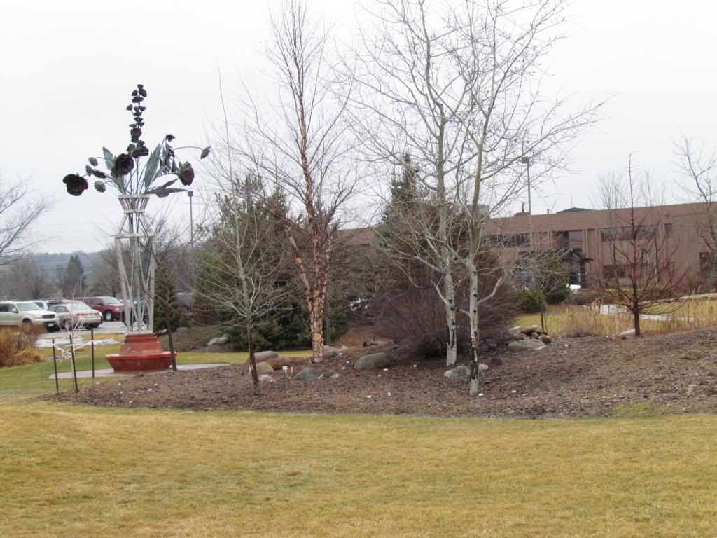
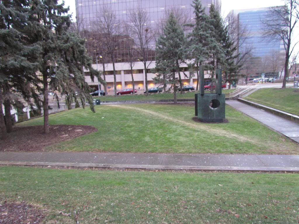
Small greenspace located in Downtown Rochester January 16th
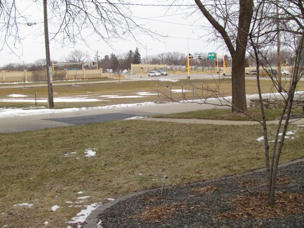
Today was a fairly nice day it was kinda partly sunny with some rain showers that turn to snow with highs in the 40s, 41.F here at my station, 40.F officially at the airport. I just had to post this photo because it is so rare to see grass in January and especially green grass for that matter. This space where the grass is well taken care of in the summer so summer watering likely kept it lush and green into the Winter months giving it that green appearance now.
Deer, Rabbits and other pests can be a huge problem in the garden in winter. I've heard news reports recently of homeowners having problems with deer and rabbits eating shrubs and causing lots of damage. Before we start with tips to help with the problem It's important to know why deer and rabbits would even want to eat the bushes in the first place. Deer cause damage by ripping branches off trees, but especially evergreens. Arborvitae are especially liked by deer. Ever see those bushes near woods like with what appear to be puff balls on top of a stick? Those are likely arborvitae branches that have been eaten by deer as far as they can reach causing that effect. Deer can also cause damage to trunks of young trees when male deer rub their antlers against the trunk scraping off bark. Rabbits are a bit different in the damage they cause but it is also from feeding. Rabbits chew on bark of young trees and thin barked trees and removing it and cutting off the cambium and phloem layers lie with in 2 inches below the bark. These layers are critical for trees and shrubs survival. If bark is removed completely around the young tree or shrub will die back to the point of injury and will have to regrow new shoots. If they have damaged a blooming shrub you've probably lost flowers for that year. If it is a tree they've damaged the tree can survive but it will be set back a few years, and will have to go through pruning programs to correct it from co dominate leaders. Also watch out if a fruit tree has been damaged, sometimes fruit trees are grafted and if the injury occurs below the graft, you will be left with the root stock that fruit tree was grafted onto which is more then likely produces un wanted fruit quility.

Wichita Blue Juniper, Juniperus scopulorum 'Wichita blue'
There are many products out there to repel deer and rabbits, and in many cases these do work, but you have to spray them on every time it rains, and also every few weeks to re new the scent. I think a product like this is great in the summer for a wanted plant, but for trees and shrubs it is difficult and timely. I believe there is only 3 real methods that will work to really protect trees and shrubs from injury. Complete Fencing off of the the tree or shrubs is a great full proof way to keep pests from munching on trees and shrubs, and it is especially easy for rabbits. I often just make a fence circle and that is enough. For deer it will require more extensive fencing and possibly electric fence. Another method to prevent damage from deer is pruning trees and shrubs in a way that takes off all small branches to the point that deer cannot reach it, of course this significantly alters the shape. My last an best way to keep pests from feeding is to not plant varities of shrubs that attack deer and rabbits! Plants like Apple trees and arborvitae attract these pests because they like to feed on them, but if a type of tree or shrub that is chosen that taste bad to deer, they will not be as attacked to it. Like instead of planting arborvitae plant Juniper pictured above, which looks great and is much less often invaded by pests.
Small greenspace located in Downtown Rochester January 16th
Today was a fairly nice day it was kinda partly sunny with some rain showers that turn to snow with highs in the 40s, 41.F here at my station, 40.F officially at the airport. I just had to post this photo because it is so rare to see grass in January and especially green grass for that matter. This space where the grass is well taken care of in the summer so summer watering likely kept it lush and green into the Winter months giving it that green appearance now.
Tuesday, January 15, 2013
Temperatures swing back in forth this week. Mild Wednesday with chance of light accumulating snows, Cool Thursday, 20s for highs, then very mild Friday with highs in the 40s before an arctic outbreaks arrives by weeks end single digits highs likely and it appears little snowcover will be gained before it arrives. Updated X1
Regional Weather Veiw
The region is in a change of weather patterns this week ahead of a major arctic blast poised to move southeast later this week. Ahead of this airmass, mild weather will be seen. especially in new snow less areas that developed from last week. With a jet stream located near us and with a northwest flow in place several small clipper systems over the course of of next week. A significant cold arctic outbreak will arrive early next week sending very cold temperatures and a chance for clippers continuing to our northeast.
Regional Weather View.
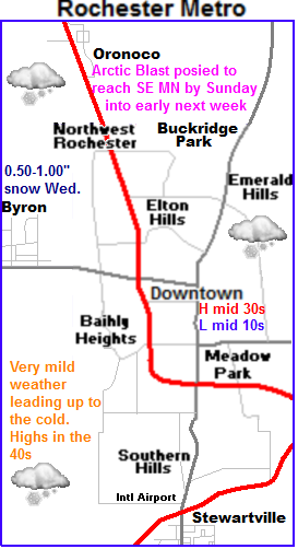 Clipper Wednesday
For us this week we can expect warmth through the rest of this week. Some days will even be on the quite warm side. Wednesday ( tomorrow) is our next shot of snow, it will be light in nature and will be done by Wednesday Evening. and accumulations will be light in nature generally around a half inch. Possibly 1 inch being on the very generous side. Thursday will be sunny and cooler with highs in the 20s behind this system, wind chills will be quite cold with breezy west winds. Lows will fall into the mid 10s
Warmth on Friday
Friday as a clipper system passes to the Northeast warm air will be sent back in to Minnesota and enhanced by the fact that we have no snowcover. With breezy southwest winds in places, highs will reach the middle 40s with the potential for higher temps in the upper 40s depending on how far north the clipper goes.
Big cooldown by the weekend. Significant arctic air in place by Sunday
I wanted to spend the majority of the time in this forecast on the cold air which has been bottled up in Canada for the last month that is about to make a huge advancement southward starting late Saturday as a cold front sweeps through. Highs Saturday will start in the upper 30s as mile air will still be in place but they will drop from there, and wind chills will make it feel colder as strong winds gust from the west over 40MPH at times. There will be slight chance of snow on Saturday with the arrival of the air but accumulations look very low, little to none. It is actually looking like we may enter the arctic blast with little to no snowcover on the ground, which will in turn mean moderated temperatures from what they could be, but at the same time it is unfortunate that we may not have the proper protection for landscapes that snowcover provides. Sunday and especially Monday the full brunt of the arctic air will be in place. Highs on Sunday will be in the upper single digits, with lows falling into the middle to upper single digits below zero. Monday will be cold, the coldest we've seen for highs in some time. Highs are expected to be only in the middle single digits, with lows falling to the double digits below zero in places. The cold air will stay in place at least the 1st half of next week, any moderate by Thursday. This arctic outbreak will be enhanced by the fact that we had a very warm winter last year. People should spend the ample time preparing for the cold weather that is expected.
Thursday, Sunny and cooler. Breezy west winds with chilly winds chills. Highs in the middle 20s. Thursday Night, Increasing clouds with lows in the upper 10s.
Friday, Windy, Significantly warmer. Sunny with winds gusting to 35MPH Highs in the lower to mid 40s Friday Night, increasing clouds with lows in the upper 20s.
Saturday, Windy and colder, A chance of flurries, then clearing skies. Winds 35MPH gusting to 45MPH Highs in the upper 20s before dropping. Saturday Night, breezy with cold wind chills. Lows in the lower single digits to lower single digits below zero.
Sunday, Cold with very cold wind chills. Breezy. Partly Sunny with a chance for flurries. with highs in the upper single digits. Sunday Night, Clear skies, lows in the mid single digits below zero.
Looking Ahead
Looking towards next week be prepare for the peak of the arctic blast arriving will occur on Monday and Tuesday of next week. It will be sunny, but highs will only be in the single digits and lows will be in the 10s below zero range. The coldest we've seen in at least a year. Wednesday the 15th looks like the next chance of snow for us, a small clipper may deliver some light snow to our area but it looks light. Friday the 25th next week a bigger more potent clipper system moves southeast from North Dakota and delivers snow to much of the state, but the heaviest looks to be just north of our area at this time. Temperatures are warming up slightly during this time. By Saturday and Sunday the 26th/27th a brief warmup arrives and it appears dry. We continue to develop towards a drier warmer pattern as the end of the month approaches. The jet stream is keeping most of the snowfall to our north, but changes will occur to this as the month goes on.
The region is in a change of weather patterns this week ahead of a major arctic blast poised to move southeast later this week. Ahead of this airmass, mild weather will be seen. especially in new snow less areas that developed from last week. With a jet stream located near us and with a northwest flow in place several small clipper systems over the course of of next week. A significant cold arctic outbreak will arrive early next week sending very cold temperatures and a chance for clippers continuing to our northeast.
Regional Weather View.
 Clipper Wednesday
For us this week we can expect warmth through the rest of this week. Some days will even be on the quite warm side. Wednesday ( tomorrow) is our next shot of snow, it will be light in nature and will be done by Wednesday Evening. and accumulations will be light in nature generally around a half inch. Possibly 1 inch being on the very generous side. Thursday will be sunny and cooler with highs in the 20s behind this system, wind chills will be quite cold with breezy west winds. Lows will fall into the mid 10s
Warmth on Friday
Friday as a clipper system passes to the Northeast warm air will be sent back in to Minnesota and enhanced by the fact that we have no snowcover. With breezy southwest winds in places, highs will reach the middle 40s with the potential for higher temps in the upper 40s depending on how far north the clipper goes.
Big cooldown by the weekend. Significant arctic air in place by Sunday
I wanted to spend the majority of the time in this forecast on the cold air which has been bottled up in Canada for the last month that is about to make a huge advancement southward starting late Saturday as a cold front sweeps through. Highs Saturday will start in the upper 30s as mile air will still be in place but they will drop from there, and wind chills will make it feel colder as strong winds gust from the west over 40MPH at times. There will be slight chance of snow on Saturday with the arrival of the air but accumulations look very low, little to none. It is actually looking like we may enter the arctic blast with little to no snowcover on the ground, which will in turn mean moderated temperatures from what they could be, but at the same time it is unfortunate that we may not have the proper protection for landscapes that snowcover provides. Sunday and especially Monday the full brunt of the arctic air will be in place. Highs on Sunday will be in the upper single digits, with lows falling into the middle to upper single digits below zero. Monday will be cold, the coldest we've seen for highs in some time. Highs are expected to be only in the middle single digits, with lows falling to the double digits below zero in places. The cold air will stay in place at least the 1st half of next week, any moderate by Thursday. This arctic outbreak will be enhanced by the fact that we had a very warm winter last year. People should spend the ample time preparing for the cold weather that is expected.
Thursday, Sunny and cooler. Breezy west winds with chilly winds chills. Highs in the middle 20s. Thursday Night, Increasing clouds with lows in the upper 10s.
Friday, Windy, Significantly warmer. Sunny with winds gusting to 35MPH Highs in the lower to mid 40s Friday Night, increasing clouds with lows in the upper 20s.
Saturday, Windy and colder, A chance of flurries, then clearing skies. Winds 35MPH gusting to 45MPH Highs in the upper 20s before dropping. Saturday Night, breezy with cold wind chills. Lows in the lower single digits to lower single digits below zero.
Sunday, Cold with very cold wind chills. Breezy. Partly Sunny with a chance for flurries. with highs in the upper single digits. Sunday Night, Clear skies, lows in the mid single digits below zero.
Looking Ahead
Looking towards next week be prepare for the peak of the arctic blast arriving will occur on Monday and Tuesday of next week. It will be sunny, but highs will only be in the single digits and lows will be in the 10s below zero range. The coldest we've seen in at least a year. Wednesday the 15th looks like the next chance of snow for us, a small clipper may deliver some light snow to our area but it looks light. Friday the 25th next week a bigger more potent clipper system moves southeast from North Dakota and delivers snow to much of the state, but the heaviest looks to be just north of our area at this time. Temperatures are warming up slightly during this time. By Saturday and Sunday the 26th/27th a brief warmup arrives and it appears dry. We continue to develop towards a drier warmer pattern as the end of the month approaches. The jet stream is keeping most of the snowfall to our north, but changes will occur to this as the month goes on.
Sunday, January 13, 2013
New name and new look.
I want to first start off my saying today it occurred to me that my blog has been in operation for it's 6th year now. I've made over 1,177 posts and over 46 thousand views since I started it 2008. I've decided recently there was a need for a new name to my blog and a new look to go with this new name. My passion for horticulture has been strong through my childhood as many have seen over the years. My love for gardening and horticulture is continuing to expand, so much so I decided many years ago that I wanted this field to be my profession. I am now near the end of my college career ( last semester) for a horticulture diploma I will revive in May of this year, and I will some day have an eventual career in this field. Weather on the other has has been with me for just as long as I've had a passion for gardening, and this will continue. At first I wanted to create a separate blog for gardening and weather, but I do not want the care of running two blogs. I also noted that my blog does not show much of my passion for gardening so I decided to rename my blog to Southeast Minnesota Weather and Gardening to show my passion for horticulture. I decided a new look was also appropriate as well. Other changes that will I will also be posting more often about gardening and I will now include botanical names for plants in my postings.
Changes Seen: New look and new name, More posts about gardening with names for plants photographed.
What will not change. The link name: seminnesotaweather.blogspot.com will remain the same. Weather posts, warnings and follow ups will remain the same as always.
I hope you will enjoy these changes as much as I will, Thanks,
Blog Owner Derek M.
Saturday, January 12, 2013
Rain and warmth in the mid to upper 40s seen this past Thursday and Friday. Snowcover is now sigificantly lacking. Sharp cold front passed through overnight.
Snowcover as of January 12th 2013
A center of a low pressure system tracked north over South Dakota into Northwest Minnesota. This placement brought warmth and the 1st rain of the year surging northward out of Iowa into most of Minnesota over the past couple days. A completely different story was taking place on the cold side of the storm as snows and blizzard conditions were seen in Northwestern Minnesota and North Dakota. In Southeastern Minnesota, as the system began moving in rain pushed northward and it was raining in most areas after 5pm Thursday, Luckily by this time temperatures were already well above 32.F so icy roads were not a problem. Even though rain ended by 10pm Thursday, a warm airmass over a cool snowpack lead to the development of dense fog and drizzle that lasted all of Friday. By Fridays end rainfall amounts seen were around 0.25" in all areas. Interestingly enough the highest temperatures of the day did not occuar during the daylight hours Friday, as south winds continued and temperatures warmed into the middle 50s in Iowa, it pumped this air into our area all evening long. By 12am Friday Night, temperatures topped out in the lower to middle 40s over the prairie plains to even upper 40s in valley bluff regions near the Mississippi River. Snowcovered suffered significantly during this event. 2-4" of snow covered the ground before the warm up, and now afterwords most areas now only have little snowcover to around 1" of snowcover. This is the 2nd time this year we've lost our snowcover.
Passing of the cold front.
Shortly after midnight as the low moved eastward a very strong cold front swept through the area bringing northwest winds gusting near to over 40MPH, light snow and a significant temperature drop. Temperatures went from the low to upper 40s to the 10s and 20s just over a 5 hour time frame. Light snows accompanied the front as well but little to no snow accumulations were seen.
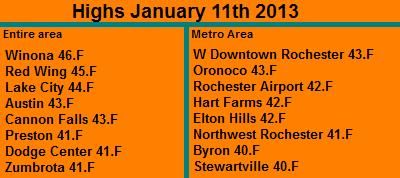
The highest temperatures spotted was Winona which warmed to 46.F at around 12am. The coolest temperatures was Stewartville at 40.F
Wind Gusts
W Downtown Rochester 41MPH
Dodge Center 39MPH
Rochester Airport 39MPH
Red Wing 38MPH
Preston 37MPH
Austin 33MPH
Winona 30MPH
Rainfall Amounts Thursday-Friday January 10-11th 2013
Dodge Center 0.38"
Red Wing 0.31"
Austin 0.28"
Winona 0.26"
Preston 0.22"
W Downtown Rochester-(My Sta) 0.21"
Rochester Airport 0.16"
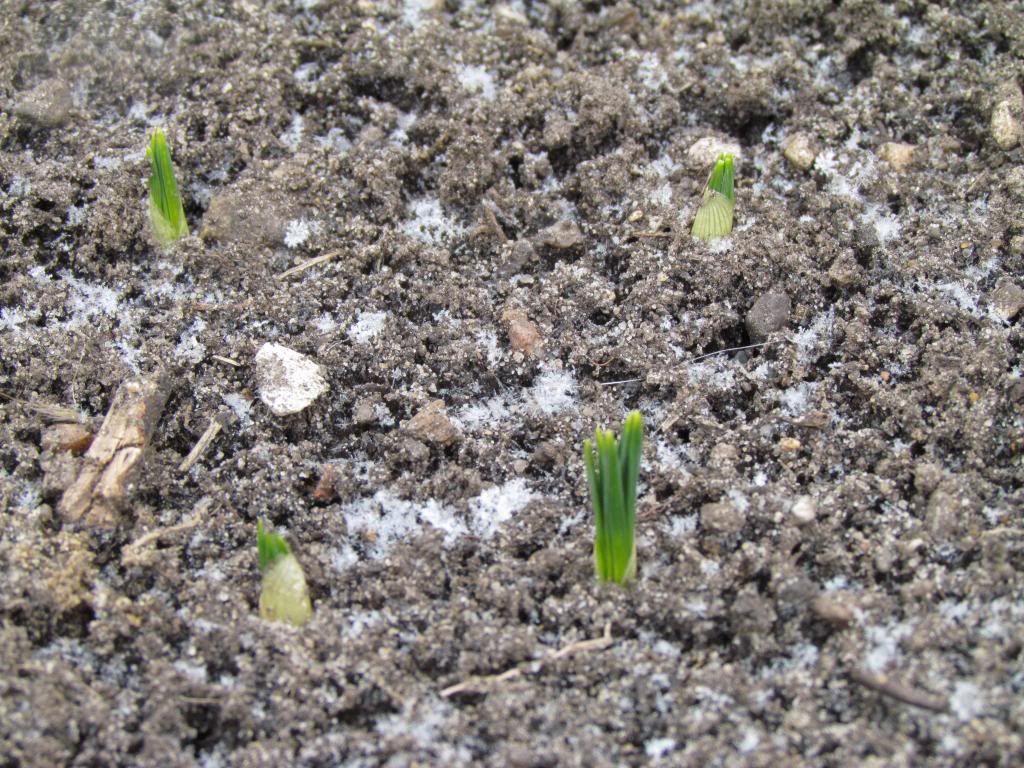
Snow Crocus Sprouts January 12th 2013
I am starting to come to a conclusion that it now will take alot to surprise me about how these plants can sprout so early. It's not even February and here they are, all it took is the melting of the snowcover. The variety of Crocus above is Snow Crocus I planted this past fall so there known for being early. It is likely these sprouted under the snowcover, and they are now exposed now that the snow melted. I am not concerned that these will not make it through the rest of winter. As long as we can get some snowcover on them to protect them from extreme temperatures, they will make it through just fine.
Tuesday, January 8, 2013
Warm for the rest of the work week. Sunny and breezy Wednesday, Rain and drizzle developing Thursday. Snowpack to take a hard hit. Then much colder temps and light snow for the weekend, light accumulation.
Regional Weather View
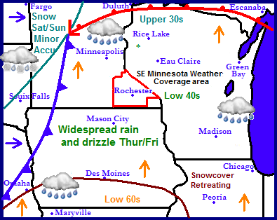
A mild weather pattern has overtaken the Upper Midwest for the remainder of the week. A low pressure system will arrive from the south spreading in warmth and rain across Eastern Minnesota, Wisconsin, Iowa and Illinois. Most of the snow pack which covers at least 95% of the region will be melting and retreating north this week. Another storm system riding behind the one which will produce rain will bring snow accumulations to Northwestern Minnesota on Saturday and Sunday. This storms cold front will sweep east bringing an abrupt end to the warmth across the area, and bringing in more seasonable temps.
Local and Metro views.
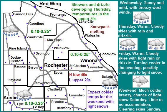
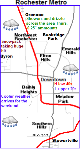 We will have one more sunny day Wednesday with mild temperatures in the middle to upper 30s, before clouds increase ahead of the next weather system arriving Thursday. Light rain and drizzle will spread northward from Iowa much of the day Thursday, temperatures will warm well into the upper 30s with the potential of a 40 degree reading or two, so ice will not be a problem. Lows Thursday Night will not even fall below freezing, and we can expect light drizzle to continue through the night. Most of Friday be much of the same, with drizzle and clouds and warm temperatures in the Upper 30s. A cold front will sweep through late Friday, winds will turn WNW and bring in much colder temperatures, and for a time drizzle may turn to freezing drizzle and light snow as colder air arrives. By the time the thaw is done late Friday most of the snowcover, which at last estimate was about 5 inches currently in our area will be melted. Saturday will be colder with breezy west winds. Light snow or flurries will be a possibility, accumulations will be light, under a half inch. The biggest story Saturday will be colder temperatures which will be in the mid 20s. Lows will fall to the single digits. Expect the chance of snow to end by Saturday Night. Sunday will be even colder, with highs only expected in the middle to upper 10s. with a chilly northwest wind. Skies will be partly sunny. Sunday Night will be clear with lows falling into the lower single digits, to possible below zero.
Wednesday, Sunny, mild, breezy west winds. Highs in the mid to upper 30s. Wednesday Night, Clear skies, lows in the middle 20s. Increasing clouds late.
Thursday, Warm, Cloudy with drizzle and light rain developing. Highs in the upper 30s to lower 40s. Thursday Night, Drizzle and light rain. Lows in the lower to middle 30s.
Friday, Warm, Cloudy with drizzle at times. Highs in the upper 30s to lower 40s. Rainfall amounts 0.10-0.25" Friday Night, Turning breezy and cooler, Drizzle turning to light flurries. Little snowfall accumulation. Lows in the upper 20s
Saturday, Much Colder and breezy, Cloudy with a chance of light snow. West winds gusting to 20MPH. little to no snow accumulation. Saturday Night, Cloudy skies. Cool with lows in the low to mid single digits.
Sunday, Cool, Partly Sunny with highs in the mid to upper 10s. Sunday Night, Clear Skies, Lows in the low to mid single digits.
Looking Ahead
Next week will be cool and dry, Temperatures will likely be in the 10s to 20s. There will be a chance of light snow on Wednesday and Thursday the 16th and 17th with a couple weak clipper systems that will bring down a cool shot of air for the end of the week. We will have another chance of light snow on Saturday the 19th as warm air pushes east. After Sunday the 20th the are un reliable. Currently they show a shift in the pattern with a chance of a snowstorm for the 24th across Iowa, Minnesota and Wednesday Wisconsin with a strong shot of arctic air, but the models have been back in forth with this so I am not very confident in this occurring yet.
A mild weather pattern has overtaken the Upper Midwest for the remainder of the week. A low pressure system will arrive from the south spreading in warmth and rain across Eastern Minnesota, Wisconsin, Iowa and Illinois. Most of the snow pack which covers at least 95% of the region will be melting and retreating north this week. Another storm system riding behind the one which will produce rain will bring snow accumulations to Northwestern Minnesota on Saturday and Sunday. This storms cold front will sweep east bringing an abrupt end to the warmth across the area, and bringing in more seasonable temps.
Local and Metro views.
 We will have one more sunny day Wednesday with mild temperatures in the middle to upper 30s, before clouds increase ahead of the next weather system arriving Thursday. Light rain and drizzle will spread northward from Iowa much of the day Thursday, temperatures will warm well into the upper 30s with the potential of a 40 degree reading or two, so ice will not be a problem. Lows Thursday Night will not even fall below freezing, and we can expect light drizzle to continue through the night. Most of Friday be much of the same, with drizzle and clouds and warm temperatures in the Upper 30s. A cold front will sweep through late Friday, winds will turn WNW and bring in much colder temperatures, and for a time drizzle may turn to freezing drizzle and light snow as colder air arrives. By the time the thaw is done late Friday most of the snowcover, which at last estimate was about 5 inches currently in our area will be melted. Saturday will be colder with breezy west winds. Light snow or flurries will be a possibility, accumulations will be light, under a half inch. The biggest story Saturday will be colder temperatures which will be in the mid 20s. Lows will fall to the single digits. Expect the chance of snow to end by Saturday Night. Sunday will be even colder, with highs only expected in the middle to upper 10s. with a chilly northwest wind. Skies will be partly sunny. Sunday Night will be clear with lows falling into the lower single digits, to possible below zero.
Wednesday, Sunny, mild, breezy west winds. Highs in the mid to upper 30s. Wednesday Night, Clear skies, lows in the middle 20s. Increasing clouds late.
Thursday, Warm, Cloudy with drizzle and light rain developing. Highs in the upper 30s to lower 40s. Thursday Night, Drizzle and light rain. Lows in the lower to middle 30s.
Friday, Warm, Cloudy with drizzle at times. Highs in the upper 30s to lower 40s. Rainfall amounts 0.10-0.25" Friday Night, Turning breezy and cooler, Drizzle turning to light flurries. Little snowfall accumulation. Lows in the upper 20s
Saturday, Much Colder and breezy, Cloudy with a chance of light snow. West winds gusting to 20MPH. little to no snow accumulation. Saturday Night, Cloudy skies. Cool with lows in the low to mid single digits.
Sunday, Cool, Partly Sunny with highs in the mid to upper 10s. Sunday Night, Clear Skies, Lows in the low to mid single digits.
Looking Ahead
Next week will be cool and dry, Temperatures will likely be in the 10s to 20s. There will be a chance of light snow on Wednesday and Thursday the 16th and 17th with a couple weak clipper systems that will bring down a cool shot of air for the end of the week. We will have another chance of light snow on Saturday the 19th as warm air pushes east. After Sunday the 20th the are un reliable. Currently they show a shift in the pattern with a chance of a snowstorm for the 24th across Iowa, Minnesota and Wednesday Wisconsin with a strong shot of arctic air, but the models have been back in forth with this so I am not very confident in this occurring yet.
Thursday, January 3, 2013
Dry and seasonible strech ahead for the rest of this weekend into the weekend. January thaw by early next week, sunshine with highs in the mid 30s expected. Next chance of moisture next Thursday? Updated X1
Regional Weather View
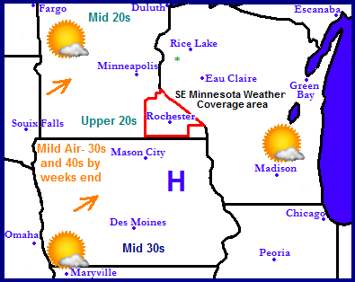
A very dry pattern has set up across the Upper Midwest. A split level flow has allowed for all the storm systems to remain north and south of the region, bringing dry weather with seasonable temperatures. Early next week southwesterly winds will spread continued sunshine and warmth to the region with high temperatures reaching the lower 30s to as high as the mid 40s across southern Missouri and Iowa. The regions next change of precip will be Thursday of next week when a storm system will move across the central U.S bringing rain and snow to the area.
Local and Metro views.
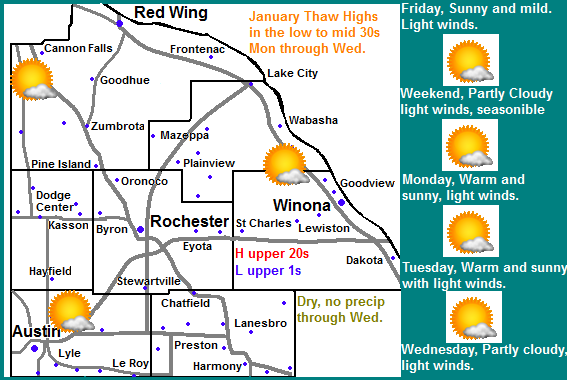
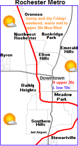 This week through this weekend into the 1st part of next week will be very quiet for the area. It will be a weather pattern which will bring multiple days of weather which will be a near repeat of its self. We can expect Friday through Sunday to feather calm dry and sunny weather which highs ranging from the middle to upper 20s, and lows in the upper single digits to lower 10s. Monday, Tuesday and Wednesday will bring in even milder weather as winds turn southwesterly. Highs will be in the lower to middle 30s each day with lows warming to the mid 10s to lower 20s. Next chance of precipitation in the form of rain will be Thursday.
Friday, Sunny skies, seasonable. Highs in the upper 20s, light winds.Friday Night, Clear skies, lows in the upper single digits to lower 10s
Saturday, Partly Cloudy skies, seasonable. Highs in the middle 20s, Light winds. Saturday Night, Partly Cloudy, lows in the upper 10s
Sunday, Sunny skies, seasonable. Highs in the middle 20s. Sunday Night, Clear skies, low to mid 10s.
Monday, Mild! Sunny skies, Breezy southwest winds. Highs in the low to mid 30s. Monday Night, Clear skies, lows in the mid 10s
Tuesday, Mild! Partly Cloudy Skies,, breezy southwest winds. Highs in the low to mid 30s. Tuesday Night, Clear skies, lows in the upper 10s to low 20s.
Wednesday, Warm, Cloudy Skies, breezy southwest winds. Highs in the mid to upper 30s. Wednesday Night, Increasing clouds. Lows in the middle 20s
Looking Ahead-Thursday the 10th is the next shot of precip in the form of rain
Most of this month could take on a fairly active note after this quiet weather pattern. next chance of precip in the form of rain will be from a quick moving storm system moving up through the central U.S on Thursday January 11th. Another quick moving, and stronger storm will be right on its heels and could accumulating snow to our area and wind Saturday and Sunday January 12th and 13th. Most of the accumulating snow looks to be across most of Minnesota with this potential storm. Significantly colder air rushes in southward behind this storm introducing a cool moist northwest flow pattern which could send in a few minor clipper systems. One on the 15th and another on the 16th.
A very dry pattern has set up across the Upper Midwest. A split level flow has allowed for all the storm systems to remain north and south of the region, bringing dry weather with seasonable temperatures. Early next week southwesterly winds will spread continued sunshine and warmth to the region with high temperatures reaching the lower 30s to as high as the mid 40s across southern Missouri and Iowa. The regions next change of precip will be Thursday of next week when a storm system will move across the central U.S bringing rain and snow to the area.
Local and Metro views.
 This week through this weekend into the 1st part of next week will be very quiet for the area. It will be a weather pattern which will bring multiple days of weather which will be a near repeat of its self. We can expect Friday through Sunday to feather calm dry and sunny weather which highs ranging from the middle to upper 20s, and lows in the upper single digits to lower 10s. Monday, Tuesday and Wednesday will bring in even milder weather as winds turn southwesterly. Highs will be in the lower to middle 30s each day with lows warming to the mid 10s to lower 20s. Next chance of precipitation in the form of rain will be Thursday.
Friday, Sunny skies, seasonable. Highs in the upper 20s, light winds.Friday Night, Clear skies, lows in the upper single digits to lower 10s
Saturday, Partly Cloudy skies, seasonable. Highs in the middle 20s, Light winds. Saturday Night, Partly Cloudy, lows in the upper 10s
Sunday, Sunny skies, seasonable. Highs in the middle 20s. Sunday Night, Clear skies, low to mid 10s.
Monday, Mild! Sunny skies, Breezy southwest winds. Highs in the low to mid 30s. Monday Night, Clear skies, lows in the mid 10s
Tuesday, Mild! Partly Cloudy Skies,, breezy southwest winds. Highs in the low to mid 30s. Tuesday Night, Clear skies, lows in the upper 10s to low 20s.
Wednesday, Warm, Cloudy Skies, breezy southwest winds. Highs in the mid to upper 30s. Wednesday Night, Increasing clouds. Lows in the middle 20s
Looking Ahead-Thursday the 10th is the next shot of precip in the form of rain
Most of this month could take on a fairly active note after this quiet weather pattern. next chance of precip in the form of rain will be from a quick moving storm system moving up through the central U.S on Thursday January 11th. Another quick moving, and stronger storm will be right on its heels and could accumulating snow to our area and wind Saturday and Sunday January 12th and 13th. Most of the accumulating snow looks to be across most of Minnesota with this potential storm. Significantly colder air rushes in southward behind this storm introducing a cool moist northwest flow pattern which could send in a few minor clipper systems. One on the 15th and another on the 16th.
Tuesday, January 1, 2013
2012 Summary. A year to remember! It will go down as the warmest in recorded history at Rochester International Airport.
This is a summary report of weather that occurred at my station in West Downtown Rochester and the Rochester Airport. 2012 will be a year to remember for many people as a year with a very early spring and hot and rather dry year. It ended out being the hottest year on record for parts of Southeastern Minnesota. I will have the happenings of 2012 into month by month statements. Information below will be from my station and yard. Below this statement I will have a statement with a summary of weather conditions from the official airport 7 miles South of my station as well. Information of records in both statements are based on records from the airport.
My Station/yard-West Downtown Rochester
Month by month
January: Average High 33.F, Average Low 18.F. Warm month, Record daily highs broken. 57.F seen the 5th. 3/4ths of the seasons total snow fell in this month 9.45"
February: Average High 37.F, Average Low 22.F Warm month 50.F the 2nd, NO days fell below zero. Lack of snow 2.75" but abundance of rain 1.62" Ice Storm seen on the 28th-29th. Very early start to spring, Crocus were in bloom by February 27th
March: Average High 61.F, Average Low 42.F Warmest March in recorded history, 83.F the 17th and 18th, Dry, Only trace of snow reported, 1.00" of rain. Only 8 days with lows below 32.F Extremely early start to spring, tulips in bloom, trees leafing out and lawns being mowed by months end.
April: Average High 61.F Average Low 41.F Much cooler and wetter, Freezing temperatures the 10th 11th and 12th, average high ended out the same as March. 77.F seen on April 24th, Trace snow reported, 2.59" of rain.
May: Average High 76.F, Average Low 54.F Warm and moderately wet. 94.F seen on May 18th.
June:Average High 84.F, Average Low 61.F Warm, Wettest month of the year 5.82" of rain fell. Severe Thunderstorm reported the 14th with damaging winds. 95.F seen on June 19th
July: Average High 91.F, Average Low 68.F Very hot, Warmest month of the year. Average was 91.F. 102.F, hottest of the year seen on the 6th.
August: Average High 83.F, Average Low 60.F Very hot and very dry. Month ended out well below normal in rain. 100.F seen on the 30th. Severe Storm reported in the 4th with damaging winds.
September: Average High 77.F, Average Low 48.F Warm and extreamlly dry. 96.F seen on the 4th. Dry warm fall lead to very dull fall colors. Severe Thunderstorm reported in the 5th, worst storm of 2012 Damaging winds reported.
October: Average High 58.F, Average Low 38.F Cooler and slightly wetter 80.F seen on the 3rd
November: Average High 48.F, Average low 30.F Extremely dry and warm. Lacking snow. 67.F seen on the 22nd. Got through entire month without accumulating snowfall.
December: Average High 33.F, Average Low 18.F Warm and wetter, 62.F seen on the 3rd. Longest stretch of days not going below zero 348 days between January last winter and December. 1st Winter Storm in one year.
Yearly Occurrences
Rainfall 28.21" -4.78" below normal
Snowfall 2011-2012 Winter Season 18.70"-33.30" below normal
Yearly Average Temperature 52.F
Warmest month on average July 91.F Coldest month of average January and December 33.F
Days with highs at or above 90.F 39 days, Days with lows below zero 3 days.
Highest snow depth 5.74" January 25th
Rainiest month June 5.82"
Snowiest Month January 9.45"
Highest Wind gust 74MPH WSW September 5th severe storm
Severe Thunderstorm Days, 3
Winter Storms 2011-2012 Winter Season, 0
Offical Rochester International Airport
Month by month
January, Average High 31.F, Average Low 14.F
February, Average High 35.F, Average Low 20.F
March, Average High 59.F, Average Low 39.F ( Warmest in recorded history)
April, Average High 60.F, Average Low 38.F
May, Average High 74.F, Average Low 52.F
June, Average High 82.F, Average Low 60.F
July, Average High 87.F, Average Low 67.F
August, Average High 80.F, Average Low 58.F
September Average High 76.F, Average Low 48.F
October, Average High 58.F, Average Low 39.F
November, Average High 48.F, Average Low 29.F
December Average High 33.F, Average Low 16.F
Yearly Occurrences
24.85" of water Precipitation fell through the year
Snowfall 2011-2012 Winter Season 20.6"
Yearly Average Temperature 50.F ( Warmest in recorded history)
2nd warmest Summer on Record
Rainiest Month May 4.85"
Snowiest Month January 8.10"
Highest Wind Gust 69MPH from the NW May 26th- Severe Thunderstorm
Happy New Year! January 1st cold temperature report. Lows fell to their coldest levels of the season so far
Happy 2013, and Welcome to January! We rang in the new year on a cold note as Lows fell to their coldest levels of the season so far. The arctic air was pulled down behind a snow system that was effecting Missouri and Kansas. Lows for January 1st ranged from double digits below zero to around -5.F These temperatures were worsened by the fact that wind chills were falling below -20.F at times. In some places this morning temperatures fell far below what they did in 2012.
Lows Reported-Area Wide
Cannon Falls -16.F
Red Wing -15.F
Zumbro Falls -16.F
Kellogg -13.F
Plainview -12.F
Dodge Center -11.F
Winona -9.F
St Charles -9.F
Wabasha -8.F
Preston -6.F
Canton -5.F
Rochester Metro
Byron -10.F
Stewartville -10.F
Rochester Airport -8.F
Oronoco -8.F
Elton Hills -8.F
NW Rochester -7.F
West Downtown Rochester-My Station -7.F
Subscribe to:
Posts (Atom)
