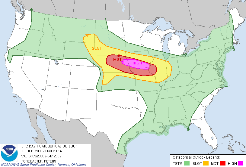
The SPC has issued a High Risk for severe weather on Tuesday which includes much of Iowa and Des Moines. This is a situation that should be taken seriously as high risks are rarely issued. The main risks for severe weather will be very high damaging winds, hail and tornadoes. Storms will develop in Nebraska and move east across Iowa likely in the form of a bow echo, which will likely arrive at night for most of the state. Along with a severe weather threat flooding will be a concern as dewpoints and rich moisture will be in place, outputs are showing 2-3" rainfall amounts are possible across a large area of Iowa over the next day. Please stay tuned to your favorite weather outlooks as this systems begins to unfold as it looks more significant at this time then it did earlier


Iowa Weather Network Warnings Map

Winter Weather Advisory
Sunday, June 1, 2014
Severe Weather Tuesday- HIGH risk now in place. Flooding possible
The SPC has issued a High Risk for severe weather on Tuesday which includes much of Iowa and Des Moines. This is a situation that should be taken seriously as high risks are rarely issued. The main risks for severe weather will be very high damaging winds, hail and tornadoes. Storms will develop in Nebraska and move east across Iowa likely in the form of a bow echo, which will likely arrive at night for most of the state. Along with a severe weather threat flooding will be a concern as dewpoints and rich moisture will be in place, outputs are showing 2-3" rainfall amounts are possible across a large area of Iowa over the next day. Please stay tuned to your favorite weather outlooks as this systems begins to unfold as it looks more significant at this time then it did earlier
Subscribe to:
Post Comments (Atom)


No comments:
Post a Comment