Map Image Legend Image

Iowa Weather Network Warnings Map

Iowa Weather Network Warnings Map

Winter Weather Advisory

Friday, March 29, 2013

1st mild airmass of the season. Seasonal tempers experienced in the mid to upper 40s

 photo IMG_5656_zps504c67a7.jpg
City snowcover as of March 29th 2013

Today was a beautiful today across Southeastern Minnesota. It was sunny and we had our first taste with highs in the upper 40s which is actually where our temperatures should be this time of year.  Many thought the weather was gorgeous and took the time to be outdoors for the first time this season. The snowpack took a huge hit and melted quite significantly. I'm seeing parts of the today I have not seen in months. Temperatures are expected to continue to be warm for Saturday with rain early in the day which may take care of most of the rest of the snowcover.

Highs Friday March 29th

 West Downtown Rochester ( my sta.) 49.F
Quarry Hill-E Rochester 49.F
Austin 48.F
Winona 48.F
Wabasha 48.F
Zumbrota 47.F
Canton 47.F
Preston 46.F
Red wing 46.F
Cannon Falls 45.F
Rochester Airport 44.F
Byron 44.F
Dodge Center 43.F


Thursday, March 28, 2013

Spring has sprung! 1st blooms of 2013!

 photo IMG_5654_zps684331be.jpg
Yellow snow crocus March 27th 2013

The 1st blooms of 2013 are among us! Several sunny days in a row with temperatures in the mid to upper 30s have lead to sheltered early blooming plants to begin flowering. Most gardens still have some snowcover but gardens located along southern exposures melt snow much quicker which allows for earlier blooms. Pictured above are yellow snow crocus located along the southern foundation of the house. Along this same area Dutch crocuses are also now budding and will soon follow. Around other places in the city I've  Winter Aconite and Snowdrops in bloom. These flowered literally popped into bloom over the past few days! It seems the long extended winter has rushed the spring bulbs into catching up to where there supposed to be, in which we are about a week and a half to 2 weeks behind. Daffodils, Tulips, Snow Iris and Hyacinths are also sprouting and will soon follow in a couple of weeks depending on weather.
 photo IMG_5650_zpsd5adf6f8.jpg

White snow Crocus March 28th 2013.

Here is a White snow crocus located in a different southern exposure garden in the lawn. These were actually sprouted back in December from very mild conditions and just have been dormant under the leaf cover until about 2 weeks ago when the snow melted away. They are very hardy flowers and can take hard freezes without damage. Last night fell to 18.F the early spring flowers are not effected.

Sunday, March 24, 2013

Spring finally arriving! Significant warm up and decreasing snowcover this week as calm weather is expected with temps rising each day, 30s, 40s then 50s a real possibility by the end of the week! Updated X1

 photo 287_zpsf92de479.png
Regional Weather view

After a very long winter with snowstorms lasting through most of this month, spring is finally going to show its face here in the Upper Midwest. A high pressure system will bring calm weather to the region through the week and the jet stream will be moving northward. This will finally bring in warm air from the southwest. By weeks end 50s could be seen as far north as Southern Minnesota with 60s in Iowa. Currently there is a significant amount of snowcover across the region, but with warm temperatures expected this week this will be decreasing significantly over the next 7 days. Weather will remain fairly quiet through the work week with only a chance of light rain showers across Southern Minnesota and Iowa come Sunday.
 photo 288_zpsca270415.png

Local and metro views

 photo 289_zpsd509d60a.pngIt's quite difficult to contain my excitement by looking at the weather maps this week. Get ready for a real Spring-like warm up! Those that have been waiting for spring will finally get to see it this week as temperatures are expected to significantly warm up through the week. We will start off cool, and end out the week with the possibility of seeing our first 50.F temperature of the season. Monday and Tuesday will be cool and will feature more clouds then sun. North winds will be breezy at times. High temperatures in the middle 30s are expected with lows in the mid to upper 10s. Wednesday and Thursday we will have brilliant blue skies and light winds and it will feel very nice. Highs will be in the upper 30s to lower 40s. Lows will be in the lower to middle 20s. Friday, Saturday and Sunday we will likely see some clouds coming back into the picture with a slight chance of light rain shows on Saturday, the rain will be very light in nature and not cause any problems. Even with the clouds and precipitation we will see the full brunt of the spring-like warm up as south winds pump in warm temperatures in the lower to middle 40s Friday and Saturday and highs in the upper 40s to lower 50s on Sunday. This will be the warmest air we have seen in month and its going to feel quite nice and the is 4-8" deep snowcover that currently covers the area will be mostly gone by Sunday.

Monday, Breezy north winds, Partly sunny skies with highs in the mid 30s. Monday Night, Mostly cloudy with lows in the mid to upper 10s.

Tuesday, Decreasing clouds. Partly Sunny skies with highs in the mid to upper 30s. Tuesday Night, Mostly cloudy with lows in the mid to upper 10s.

Wednesday, Nice! Sunny skies, light winds. Highs in the upper 30s. Wednesday Night, Partly Cloudy, lows in the upper 10s to low 30s

Thursday, Nice! Sunny skies, light winds. Highs in the upper 30s to lower 40s. Partly cloudy, lows in the mid to upper 20s

Friday, Nice! Increasing clouds. Partly cloudy to partly sunny with highs in the middle 40s. Friday Night, Cloudy skies, lows in the upper 20s to low 30s

Saturday, Mostly cloudy with showers and the possibility of an thunderstorm. Highs in the mid to upper 40s. Saturday Night, Cloudy, chance of rain mixed with snow. Rainfall amounts around 0.25"  lows in the lower 30s.

Sunday, Chances of light rain and snow early. Falling temperatures, Windy west winds gusting to 35MPH Highs in the upper 30s before falling Sunday Night, Windy with lows in the upper 10s. Winds gusting to 30MPH 

Looking Ahead

Monday the start of the 1st week of April looks cold with highs only in the 30s with bluster winds. Tuesday April 2nd a warm front brings moves north and brings us rain showers then warm temperatures and calm weather for the middle of that week, 40s and 50s could be common.  Saturday April 6th a strong low pressure system moves through and tracks from Nebraska to Northern Minnesota. This puts us on the warm side for the start but cold air is waiting to move south behind it. The model shows heavy rain showers Sunday April 7th possibly ending as light snow as cold air moves down form the northwest. Right after the storm is clears and sunny skies return out but cold temperatures remain over the area for a few days then temperatures moderate and warm up to more seasonal values around April 9th. 

Tuesday, March 19, 2013

Monday March 18th snowfall/wind event. Now 3rd snowiest March on Record at Rochester- This year is an extreme difference compared to last year.

 photo IMG_5633_zps25f8873c.jpg
 Windblown snow on a cold morning March 19th 2013

Many are starting to get exhausted with this winter weather that seems never ending at this point. Monday a quick moving storm system brought moderate to heavy snows once again into our area. This one was a different then our last few because this one came with very gusty winds 40MPH or over and significant blowing and drifting snow. The actual amounts of snow was not a problem but blowing snow made for very difficult travel. The cause of the snow was a low pressure system centered in Northern Minnesota. As this moved eastward gusty northwest winds and dropping temperatures were found on its southwest side. This storm was more like those we would experience in January and not 2 weeks from April. To add to the January-like weather very cold temperatures were seen behind the storm this morning as lows feel in the low to mid single digits. Typical highs this time of year are in the mid 40s.

Up to 3rd snowiest March at Rochester

La Crosse has not officially released anything  regarding this information but with the snow we had yesterday we are now in 3rd place for the snowiest March in recorded history.

Snowfall and Wind Reports

Minnesota City 4.00"
 West Downtown Rochester ( my sta.) 3.75" 44MPH
Rochester Airport 3.70" 40MPH
Cannon Falls36MPH
Winona 36MPH
Dodge Center 38MPH
Theilman 3.70"
Lake City 3.50"
Red Wing 3.50" 33MPH
Claremont 3.40"
Wabasha 3.20"
 Elgin 3.20"
Preston 3.20" 39MPH
Spring Valley 2.60"
Austin 2.40" 37MPH
Lanesbro 2.0"

  photo IMG_56341600x1200_zpseff83022.jpg


This year is completely opposite of last year. Taking a look at the photo above shows the huge difference in weather from this year to last year. To emphasis on this extreme difference, this time last year we were, mowing the lawn for the 1st time of the season. Early Trees/shrubs like Lilacs, Maples, Willows were leafing out. Magnolias and Daffodils were in full bloom. This year we have a thick snowcover and cannot even see the lawn.

Friday, March 15, 2013

Very wintery cool pattern will continue for at least the next week. Next chance of minor to moderate snows is Monday. Midweek of next week looks cool to even cold but at least with bright sunshine!

 photo 284_zpsd1f3cb70.png
Regional Weather View

The weather pattern for the Midwest looks very cool and wintery like. The reason for this is because the jet stream has been stuck over the Midwest for the past few weeks. Which is also the reason for the very active pattern we have been in. The next chance of a snowstorm will be Monday but there is much disagreement between the model as to where this storm will track. Parts of South & North Dakota, Minnesota and Wisconsin look to be targeted at this time. Snowcover has receded north into Iowa but it does not look like it will be progressing much more north then this because after the storm passes through it will stay cool, but it will bring in a quieter and sunnier pattern.

 photo 285_zps4c086061.png
Local and Metro views

 photo 286_zps986858ae.png
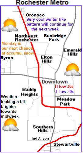
For the local area expect a cool very wintery-like pattern. Because of a southerly placement of the jet stream to out south Spring-like airmass is having only brief visits to southern Minnesota. Saturday and Sunday will be more clouds then sun with highs in the upper 20s to lower 30s which is below the average of low to mid 40s which is where we should be this time of year.

Monday is the next chance of snow

Monday is our next chance for accumulating snow here in Southeastern Minnesota but there is significant disagreement among the forecast models on the placement of this storm. European models takes it more south which would bring minor to moderate (3-5") of snowfall accumulations to our area. GFS takes the storm more north keeping it north of Minneapolis, which would only bring light snow to our area with little to no snow. I decided for right now to go with that will probably see some light snow accumulations on Monday with the majority (heaviest) accumulations being to our north.

Cool into midweek but at least sunny!

Temperatures will remain well below normal into the middle to end of next week but at least a high pressure system will bring the sun back into the picture. High temperatures Wednesday will start off downright cold in the middle 20s, then moderate to the upper 20s to lower 30s Thursday and Friday. Friday we have a shot at maybe middle 30s, which is below normal but will feel good with the high sun angle and light winds that are expected.

Saturday, Cool, Flurries possible early otherwise Mostly cloudy with breezy northwest winds to 20MPH. Highs in the upper 20s. Saturday Night, Cold, Partly cloudy with lows in the low to mid 10s

Sunday, Partly sunny skies, breezy cold winds. Highs in the upper 20s to low 30s. Sunday Night, Snow developing, Lows in the mid 20s.

Monday, Snow, possibly heavy at times. Possible Accumulations 2-4" Highs in the lower 30s Monday Night, Cold! Light snow and blowing snow, Windy with west winds gusting to 35MPH. Cold wind chills. Lows in the lower 10s to upper single digits.

Tuesday, Cold sunshine, breezy cold northwest winds. Highs in the mid 20s. Tuesday Night, Cold, lows in the upper single digits to lower 10s

Wednesday, Cool, Sunny, not as windy. Highs in the upper 20s. Wednesday Night, Cold, lows in the low to mid 10s.

Thursday, Sunny light winds, Warmer. Highs in the low to mid 30s. Thursday Night, Partly cloudy and chilly with lows in the upper 10s.

Friday, Partly Cloudy, highs in the low to mid 30s. Friday Night, Increasing clouds with lows in the upper 10s to low 20s.

Looking Ahead

GFS and European model are in complete disagreement in the long range forecast but I tend to lean towards a cooler side and pushing our spring-warmups farther and farther into March. The model shows the cold air sticking around at least for the next week, with maybe an end to that in the last week of the month. For next weekend 23rd and 24th looks sunny and cool but with the high sun angle in place we may see 30s for highs. The models are bringing in a warmer spring-like airmass to start off the last week March with the jet stream finally being allowed to possible go north of our area. If this were to take place we would see significantly warming temps and drastically melting snowcover. It must be taken into consideration the model may not be right with this trend and it could change back to a cooler trend, but at the same time this pattern were currently under wont stick in place forever so I would not be surprised if this turned out to be what happens. It is something we will just have to wait and see.

Thursday March 14th another snow event brought heavy snow and dropped a quick 1-2" Were up to the 5th snowiest March in recorded history at Rochester. Quick warm up and sunshine after the snow helped aid in Tulips sprouting!

 photo IMG_5629_zps9305bb4b.jpg
Heavy snow during the morning hours of March 14th

A quick moving clipper system and warm front brought a brief burst of heavy snow for mostly the central and northeastern parts of the area. The snow lasted for about an hour or two Thursday morning. Snow from this clipper was compact on radar but was very intense. It dropped a quick 1-2" in a about an hours time. The snow was so heavy here in Rochester I could not see the hospital 2 blocks away which is the 1st time I've had that happen. This snow causes numerous car accidents area wide because of the slippery and visibility restricting nature of the snow.

5th snowiest March in recorded history at Rochester International

NWS La Crosse has announced with the snow Thursday we are now in 5th place  for the snowiest March in recorded history at the Rochester Airport 20.30" have fallen at the airport. This compared to my station which is 7 miles north and several feet lower in elevation compared to the airport 18.25" of snow has fallen this month. If the airport were to see a few more inches before the end of the month we could easily be put in 2nd or 3rd place for the snowiest March on record.

Snow Reports

Winona 2.0"
West Downtown Rochester ( my station) 2.0"
Preston 1.90"
Nerstrand 1.30"
Mantorville 1.50"
Austin 0.30"  
 photo IMG_5630_zps8b166e14.jpg
 Sunny backyard view March 14th 2013

What a quick turn around! by 11am the snow ended and eventually by the afternoon hours the clouds cleared and we broke into brilliant sunshine with temperatures in the the mid to upper 30s with low 40s in city protected areas. All of the newly accumulated snow from the morning hours melted with our very strong mid march sun if felt great to finally see some warm sunshine.

 photo IMG_5631_zpsf693883a.jpg
 Tulips sprouting March 14th 2013

This brings a little hope to winter weary residents. Even with the very few days of sunshine we have had this month the snow has melted away from the southern foundation garden which has allowed the tulips to sprout! Also sprouting in this garden are Daffodils and Crocuses. To help explain how this is possible this garden is located next to the southern foundation of the garage where the sun heats up this area and melts snow and warms the soil much quicker then in other areas of the yard. Since I knew this would be the case I made use of this effect and planted early flowering bulbs so that I would get to enjoy spring a little earlier! Now if we can get some extended sunshine in place for more then a day or two, I would see blooms from crocus in about a week or two.

Monday, March 11, 2013

Who ever said Spring doesn't have snowstorms in Minnesota? Very high precipitation amounts past 2 days. Significant rains 0.75 to 1.00" Saturday the 9th, then Spring Snowstorm dumps half to 1 foot of heavy wet snow on Southeastern Minnesota March 10-11th. Thundersnow reported! Snow had high water contents. 2.00-2.50" precip amounts over the past 3 days


 photo IMG_5600_zps1a3e4cd3.jpg
Flooding from significant heavy March rains Saturday/Sunday March 9-10th

A unsual 1-2 punch event impacted Southeastern Minnesota early this week bringing significant amounts of heavy precipitation to Southeastern Minnesota in the past 3-4 days. First in the form of significant amounts of heavy rain fell from a storm system Saturday. Rainfall amounts ranging from 0.30 to exceeding 1.00" were reported, then as significant amounts of snow Sunday into Monday. Heavy snow developed with a snowstorm late Sunday into Monday which dropped significant to major, 6 to 12" amounts of snow on the area on top of the rain. The storm that lead to the significant rain originated in Colorado and moved up through western Kansas to about St Cloud,Minnesota. This placement sent plumes of warm air rich moist air northward out of Iowa. Rain heavy at times developed and lasted much of Saturday. There was bouts of moderate rain through out the day. Temperatures warmed to the mid to upper 30s. The highest temperature we warmed to was 37.F here in Rochester. All this preciptation at this current time could lead to spring flooding issues because with the ground being well frozen solid the rainwater just remained on top of the ground, ran off or soaked into the snowpack. The snowdepth here in my backyard here in Rochester lowered from 10.50" on Tuesday the 5th to 4.50" at the end of the rain/warmth Friday.

Rainfall Reports

Austin 1.47"
Dodge Center 1.28"
Red Wing 1.17"
Rochester airport 1.08"
W.Downtown Rochester-( My Station) 0.94"
Cannon Falls 0.66"
Preston 0.55"
Winona 0.35" 
 photo us_nc_9regradar_plus_usen_zps43949afb.jpg


  Radar from Weather.com

Immediately after the rainstorm Monday a new area of low pressure quickly developed and blossomed into a classic spring snowstorm directly over North Iowa and Southeastern Minnesota. This storm was hard to forecast due to the narrow corridor of snow and the pop up nature of the event. The storm ended up trended north at last second and the models did not pick up on it. Snowfall amounts ranged from an estimated 3-4" in the north where there are no snowfall reports to verify to reported amounts of 8-12" in central and southern parts of the area. The highest reported I came across was Spring Valley at a whopping 12.50" Temperatures dropped from the upper 30s at the start of the storm to 31-32.F producing very  heavy bands of snow reducing visibilities significantly. Snowfall rates were some of the highest the area has seen in over a year ranging from 1-2" per hour. Thundersnow was even reported in parts of the area in convective bands along the Iowa boarder in Le Roy near the city of Austin!

 photo IMG_5612_zps12acf8f3.jpg

 Backyard in March 10th-11th spring snowstorm

The snow developed Sunday evening was heavy by 7-8pm at night. Snow was of very wet nature and flake size was large due to temperatures being right around 31.F during the event of the snow. 7.25" fell in our backyard with this snowstorm. The snow has a very high moisture content 0.97" combined over the past 2 days with Saturdays rain and Sundays/Mondays snow, my station is picked up 1.91" of precipitation which is very usual. In my backyard we gained back all the snow we had lost. The snow depth rose from 4.50" back to 10.50" where it currently remains

Interesting notes:

My station received 0.94" of rain Saturday and 7.25" of snow Sunday into Monday with a water content of 0.97" this makes precipitation for the past 3 days at 1.91" which is very high for March. Most of this water soaked into the snowpack.

7.25" of snow fell today which brings the monthly total to 15.75" which is 6.85" above normal

Seasons total snow is up to 47.00" which is near normal

Snowdepth here in Rochester is 10.50" currently with a water content of
 photo IMG_5615_zpsad091529.jpg
 Snowcovered trees with the plummer house in the distance

Who ever said Spring doesn't come with snowstorms in Minnesota? It is actually fairly typical to get spring snowstorms in Minnesota. Even though temperatures are starting to warm, as more moisture becomes available and the storm track gets strong once again Minnesota becomes prone to spring snowstorms as the jet stream tries to move north. However despite the snowstorms there is usually a rapid warm up by the middle to end of the month in which the snowcover significantly decreases. The forecast shows temperatures will be in the upper 30s each day at the end of the week and into the weekend which will start to melt some of the snow we currently have. At least until our next snow.

March 9-10th snowfall amounts

Spring Valley 12.50"
Harmony 11.50"
Minnesota City 10.30"
Chatfield 10.00"
Marion 9.50"
Preston 9.0"
Rushford 9.0"
Dodge Center 9.0"
Rochester Airport 8.70"
Lanesbro 8.20"
Winona 7.50"
Kellogg 7.50"
Grand Meadow 7.30"
West Downtown Rochester-(My Station) 7.25"
Mantorville 7.0"
Claremont 6.70"
Oronoco 6.70"
Plainview 6.50"
Byron 6.50"
Wabasha 6.10"
Austin 5.0"


Sunday, March 10, 2013

Next storm quickly on the heels of this current one. Sigificant snowfall likely from a developing Winter Storm Sunday into early Monday. 7-10" likely for south and eastern parts of the area. Updated X2

 photo 282_zps4636a1e7.png

Regional weather view.

A very complex and extreamlly active weather situation taking place in the Upper Midwest this weekend. One storm has passed and now a secondary storm is expected on the heels of this one. The low pressure location will pass over Eastern Iowa bringing the threat for significant snows in Iowa, Southeast Minnesota and Wisconsin. After a brief cool down early next week, the weather will turn mild and spring like, as warm will pushes back into the region. Temperatures region wide in the 30s, 40s and 50s for multiple constructive days in a row.
 photo 283_zps07860593.png

Local and Metro views.


 photo 281_zpsb3174b83.pngSignificant snowstorm tonight

2 models the GFS and European continue to come together on a significant winter storm impacting our area tonight with heavy snow lasting into the 1st part of Monday The GFS model shows a wave of heavy snow developing in central Iowa and pushing north Sunday afternoon into the early morning hours of Monday. The snow will be very heavy at times hindering travel conditions. Accumulations will be highly dependent on where you live. The farther south and east you are the more snow you will see. It shows the heaviest accumulations in Southeast parts of the area. Winona, Preston, Austin will all see totals ranging from 7-10" Central parts of that area, Dodge Center, Rochester and Wabasha will all see totals ranging from 4-7" with generally 2-4" or less in the far northwest. The cut off in snow totals will be very sharp.  Snow type will be a wet slushy snow because of mild temperatures near freezing. This is still a developing storm and there is a bit of a failure rate with it. If the track were to shift southeast at least minute there would be significantly less snowfall, but for right now everything will be kept current.

Spring-like warm up by end of next week.

Models still continue to show a nice warm up this week but it keeps getting pushed back because of the close proximity of the jet stream. After the passing of the Winter Storm Sunday weather will remain cloudy to partly sunny through Tuesday. Highs these days will be in the low 30s. Wednesday a high pressure system will move in bringing Clearing skies and sunny conditions. With sunny skies Wednesday and light winds we can expect highs in the mid 30s and lows in the upper 10s. Thursday and Friday is when the real warm mild air will begin to move in and the feel of spring will be in the air.. Skies will range from being more cloudy to more sunny at times, but temperature regardless of the sun or clouds will be in the upper 30s to low 40s both days with lows in the mid 20s.

Sunday, Cooler and cloudy. Snow developing in the afternoon, snow will be very heavy at times. Highs in the lower 30s. Sunday Night, Snowstorm, snow could be very heavy at times. Windy with northwest winds to 30MPH Potential accumulation 7-10" far southeast, 4-7" central areas and 2-4" or less northwest areas. See map.  Lows in the mid 10s.

Monday, Cloudy with snow in the morning. Skies clearing to partly sunny in the afternoon.  Highs in th upper 20s to low 30s. Monday Night, Increasing clouds, lows in the low to mid 20s.

Tuesday, Mostly Cloudy, light winds, highs in the low 30s. Tuesday Night, Partly Cloudy skies lows in the low to mid 20s

Wednesday, Sunny skies, light winds, highs in the mid 30s. Wednesday Night, Partly Cloudy with lows in the low 20s  

Thursday, Seasonable Mostly sunny with light winds and highs in the upper 30s to lower 40s. Thursday Night, Partly Cloudy skies with lows in the mid 20s

Friday, Seasonable, increasing clouds, highs in the upper 30s to low 40s. Friday Night. Mostly cloudy with lows in the upper 20s.

Looking Ahead-Updated

Note: The long term forecast has a high failure rate and is very changeable at this time of year due to the transition of seasons. It can show one thing one day and change completely the next. Today the model shows next weekend being rather cloudy and cooler with a chance of light rain or snow Saturday. Sunday looks cloudy and cooler highs maybe near 30. Early the next week of Monday the 18th looks to start off on the cool side, with a significant warm up by midweek Wednesday and Thursday the 20th and 21st looks sunny and mild with a chance at 50s. This


Tuesday, March 5, 2013

March 4-5th Spring snowstorm dumps up to a foot of snow onto some areas over a 2 day period!

 photo Regional_Radar_for_Web_zps29fbb17e.jpg
Image credited to wzzm.com

A significant March snowstorm-The largest snowstorm to effect the area in 2 years began Monday with the 1st wave and really ramped up in a second wave that impacted the area with heavy snow and significant snowfall accumulations early Tuesday. The entire are received significant to very low end major snowfall amounts between 7 to as much as 12 inches of fresh wet snow. 12.30" of snow from both Kasson and Mantorville are the highest amounts I came across. The snowstorm its self had a very spring or March-like feel to it in that the snow was sticky and wet. This storm originated over Northwest Canada and rode the jet stream southeast from North Dakota southeast effecting around 12 states regionally. The heaviest amounts were actually fairly compacted in an area from Eastern North Dakota to Central and Eastern Minnesota and Wisconsin and it actually continued eastward to the east coast. The higher amounts were centered over an area only about 150 miles thick along this entire path
 photo IMG_5588_zps1a96e122.jpg


  Snow covered pines at the SMART Gardens at Rochester Community and Technical College

This storm was kinda complex for our area in that it was a northwest system that merged with energy from a more southern storm. After this merging the system moved east and weakened as it moved south east to Illinois and Indiana all the way to the east coast. This movement and merging of the storm brought our 1st wave of snow in Monday afternoon and it brought generally 1-3" It was mostly light in nature and ended by the evening. The second wave re developed to our west was much more heavy and more significant. Heavy snow fell through much of the overnight and early parts of Tuesday. 6-9 more inches of snow accumulated on top of what did during the 1st wave getting to our areas 7-12" storm total. Snow came to an end Tuesday evening and there was no real cold air filtering in behind this storm, another feature of later winter storms.

 photo IMG_5595_zps530fde27.jpg
Snowpiles along the road in my neighborhood March 5th 2013

Effects with this storm were plainly set on traffic and ground travel issues. Many cars got stuck right away Tuesday morning and travel across the city took much longer then normal but for the most part road crews were able to get to work and the warm nature of the storm allowed snow to melt off treated roadways quickly. Winds were not an issue at all with this storm so blowing and drifting was not a problem. Overall this storm was very typical for this part March and it classified as a late winter/early spring storm. This moisture we are receiving should really help lakes and rivers in the spring melt and add moisture to the atmosphere which could aid in spring rains later on. 

Crunching the numbers

My location received 8.50" of snow during this storm. This is the highest total in 2 years. This amount is most of the 8.90" March monthly total in 1 storm. This makes the monthly total for March so far 8.50" and the seasons total to 39.25" so far. I estimate the snowpack to b at least 10" deep currently.

Snowfall Reports-Entire Area

Kasson 12.30"
Mantorville 12.30"
 Winona 12.10"
Minnesota City 11.70"
Lake City 11.50"
Spring Valley 10.60"
Reeds Landing 10.00"
Red Wing 9.40" 
 Foutian 8.50"
Goodhue 7.80"
Austin 7.30"
Le Roy 7.00"
Peterson 6.50"

Rochester Metro

Stewartville 9.30"
Rochester Airport 8.90"
West Downtown Rochester ( my station) 8.50"
Northwest Rochester 8.50"

Sunday, March 3, 2013

Major Winter Storm Targeting The Area. 8-13" of Accumulation With Higher Ammounts Possible. Major Travel Impacts with Very Heavy Snow Reducing Visibilities.

 photo 276_zpsafc6a86c.png


Regional Weather View

Another major snowstorm is targeting the Upper Midwest only this time is has it's highest impacts set to take place in parts of North Dakota, South Dakota, Northern Iowa, Minnesota and Western Wisconsin. A strong low pressure system will race Southeastward from North Dakota and take a rather interesting path which will spread long duration snow over the central part of the Upper Midwest. After the low races Southeastward, it will stall out over Iowa on Monday Night and then gain strength before moving eastward towards Illinois. This will spread 2 waves of heavy snow which will result in major accumulations in the pink corridor highlighted above. The storm will completely clear the region by Wednesday and a high pressure system will move in spreading sunshine and spring like warmth into the region by Thursday and lasting through the weekend.

 photo 277_zps6f996ad9.png

Local weather view and metro weather view.

 photo 278_zps31c6d660.pngThe Major Winter Storm will impact Southeastern Minnesota with very heavy snow and high snowfall accumulations. There will be 2 rounds of heavy snow for the area. One early Monday as the low moves Southeast and then there will be a temporary lightening or end to the precipitation on Monday Afternoon, before it re starts up again as the low starts to strengthen and move east Monday Night. More bands of heavy snow will push into the area lasting most of Tuesday. The heaviest snow and highest accumulations will take place early Tuesday. Winds during this event will be minor compared to past storms with gusts up to 20MPH possible. Temperatures will be in the upper 20s to lower 30s during the event which will allow for snow to accumulate onto trees, especially conifers which could cause breaking limbs and isolated power outages. The snow will come to an end an all areas by Tuesday Night, leaving behind a cold breezy night in the single digits.

March 4th-5th Major Winter Storm Impacts and accumulations

Accumulations with this this major winter storm will be consistent high amounts of 8-13" Widespread throughout the entire area and effecting all areas. There is a possibility of more then 13" in isolated spots The highest impacts with this storm will be with ground travel. Both areas in the city as well as country will be effected, especially side roads that are not plow consistently. These roads will be nearly impassible by Tuesday. Snow will be heavy at times Monday and again Tuesday possibly creating low visibilities and near whiteout conditions. Breaking tree limbs and isolated power outages are also a possibility because of the heavy nature of the snow and lighter winds expected. People in the area should prepare for a major winter storm to impact the area for the next 2 days. Travel will be difficult if not impossible on some un plowed roads.

 Clearing our and warming up starting Wednesday

Wednesday a high pressure will move in putting an end to the snow and bringing sunshine with highs in the upper 20s and lower 30s back into the picture. Thursday breezy south winds gusting to 25MPH will bring in a gradual warming trend which will bring continued sunshine for the rest of the week into the weekend. Highs will be consistently in the mid to upper 30s each day and in the 20s each night. Highs will begin to approach 40 by Sunday which will put a big dent in the new snowcover we receive.

Monday, Snow, Snow will be heavy at times in the morning. Snow tapering to light snow and possibly ending the the afternoon. Highs in the upper 20s. Monday Night, Snow developing. Snow will be heavy at times reducing visibilities. Lows in the lower 20s.

Tuesday, Major Winter Storm. Snow, Snow will be heavy at times reducing visibilities in the morning and afternoon. Gusting north winds to 25MPH Snow tapering and ending in the afternoon. Storm Total Snow accumulation 8-13" Tuesday Night, Clearing skies with breezy north winds. Lows in the upper single digits to low 10s.

Wednesday, Cool, Sunshine with highs in the upper 20s to lower 30s. Wednesday night, Clear skies with lows in the middle 10s.

Thursday, Sunny with breezy south winds to 25MPH. Highs in the low to mid 30s. Thursday Night, Partly Cloudy with lows in the mid to upper 20s.

Friday, Partly Cloudy with highs in the mid to upper 30s.Friday Night, Partly Cloudy with lows in the middle 20s.

Saturday, Partly Sunny with highs in the upper 30s. Saturday Night, Mostly Cloudy, lows in the middle 20s.

Sunday, Mostly Sunny skies, with highs in the upper 30s to lower 40s. Sunday night, Mostly Cloudy with lows in the upper 20s.

Looking Ahead

Looking beyond the weekend into the 1st part of next week shows a storm system spreading  a chance of rain and snow into across Iowa and into our area on Monday the 11th of March. At this time this system does not appear to significant. Tuesday March 12th all the rain turns into a wet snowfall as temperatures cool slightly. March 13th the pattern begins to quiet down as a huge ridge of high pressure starts to warm things up to the west pushing the jet stream north. This could put us in favor for a significant warm up in the 2nd half of March if this pattern continues to be favored. At this point GFS and European model continue to disagree in the long term so its just a waiting game on what will happen.