Map Image Legend Image

Iowa Weather Network Warnings Map

Iowa Weather Network Warnings Map

Winter Weather Advisory

Wednesday, February 29, 2012

Febuary 28-29th Sigificant Midwest Storm-SE Minnesota Sigificant ice brings down many large tree limbs. Heavy rainfall ammounts over and inch with 1st Thunderstorms of the season.

System Radar View February 29th 2012 Image from SPC

A Significant weather system which packed a punch in nearly every start in the Upper Midwest effected much of the region today. The biggest effect in our area was significant ice accumulations causing isolated power outages. Power outages were reported in Eastern Wabasha County around Reads Landing and parts of the city of Rochester. Ice accumulations on trees also lead to widespread area wide minor to significant tree damage, especially for evergreen trees. Heavy, drought easing rains in excess of 1 inch were seen most of the area bringing creeks and river are back up. The last thing to note is the area also got the first official thunderstorms of the season occurred late last night as convective from the storms in Nebraska earlier in the evening moved northeast all the way across Iowa and into Southern Minnesota. Above the radar image showing 2 vigorous bands of precip. One falling as rain in Southern Minnesota to heavy snow in Northern Wisconsin, the other a wave of heavy rain Thunderstorms in Iowa, which eventually made their way Northeast and gave us our 1st thunderstorms of the season! The low can be seen in South Dakota.


 Front Yard View February 29th 2012.

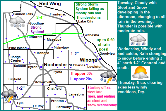
Here in Rochester going to college Tuesday Morning we had light snow already starting around 1:30 the intensity of the snow picked up but none of it accumulated. Around a half hour later that it changed to freezing rain which became moderate at times. The problem was the temperature was hovering right around 32.F which thankfully kept the roads wet, but thick ice started to developed on trees and power lines which caused problems related with this described below. Eventually around 12AM once the center of low pressure moved into Minnesota warmer air was nudged northward which warmed temperature has warmed to 33.F which ended the icing problem, We had a brief break between precip bands before thunderstorms in a band of moderate to heavy precip moved in around 2:00AM. This produced the 1st thunderstorm of the season at my location, and many other across the area! The rain was so heavy for a time that local news reported that slow storm drains were causing some minor flooding on Broadway Ave. In total this system dropped 1.62" of rain here in Rochester and trace amounts of snow/sleet. This is the highest amount of rain since August, and actually the highest amount since I moved down here!

 Significant Tree damage from ice accumulations

Tree Damage in St Marys Park February 29th 2012

 Ice accumulations and falling tree limbs and problems associated with this was the biggest problem with this storm has in our area, Moderate to even heavy freezing rain at times coupled with breezy southeast winds caused tree limbs to sag and snap. The branches on our neighbors tree were hanging so low and one point it was almost touching there roof, around the time of this we were having power flickers. The bulk of the damage was done to evergreen trees, especially the White Pines. Driving around Wednesday It seemed that every pine grove had at least some branches down, some lost a large amount of branches.

Large branches down St Marys Park February 29th 2012

In this photo two large branches can be seen one in the foreground and one in the background. These old cedar trees at the park took a hard hit with this ice there were multiple big branches down across the park, the biggest one was at least 10 inches in diameter, and would not be able to be removed without first cutting it up.

Large branch down near RCTC February 29th 2012

This is a large branch that I saw down in a long row of White Pines in the area of my school, this branch was around 10 inches in diameter as well.

White Pine Damage February 29th 2012

This was the worse damage that I came across. This tree lost many large branches and much of its top. Most of the branches up and down the tree on the winded southeast side of the tree were broken.

Storm Total Rainfall

The areas received very beneficial rains, The highest area rainfall was more then 2 inches in Reg Wing! Everyone got over at least a half inch, which will help with our drought conditions.


Other regions effected.

 Photo of the heavy snow near my hometown Turtle Lake,WI February 29th


This was a very dynamic storm becuase while we were getting heavy rain, some areas were getting very heavy snow with major snowfall amounts. Even 115 miles made a huge difference, my hometown area had heavy snowfall amounts around 9 inches with strong winds. My dad and family  said the snow was extremely wet in nature. Even further north very dangerous blizzard conditions with power outages were reported with this storm around Duluth, which reported around 7 inches of snow with winds up to 60MPH! people who are interested in hearing more about the weather in this area should see Tim's Weather Blog

Monday, February 27, 2012

Very strong storm system effecting the state tomrrow! Windy with sleet and snow, early, minor accumulations then quickly changing to rain, thunderstorms possible - Up to half inch of rainfall possible.

Regional weather view.

A Dangerous Major Winter Storm is the top of the story effecting the Upper Midwest, Major snowfall accumulations are likely in Northern Minnesota and Wisconsin Blizzard conditions are likely in Western Minnesota with significant accumulations along to the south of this. In Iowa, Southern Minnesota and Central Wisconsin it will start off as sleet and quickly change to rain, where thunderstorms are possible. Wednesday whatever precip is left will turn to all snow region wide, but by then moisture will move off to the east. Thursday looks to have clearing skies with fair temps region wide.

Local and Metro views.

Note: This is a difficult storm to forecast for, This forecast is subject to significant chances depends on the exact track of this low.

Tomorrow a strong weather system will work across the state. Starting Tuesday a strong low pressure will track across Northern Iowa before pushing northward into Southern Minnesota. This will mean that our area will fall under the warm side of this storm keeping the high snow totals well to our north. We can expect that Precip will start in the afternoon on Tuesday as Sleet and snow possibly even freezing rain as temps start off below freezing, quick 1-2" may accumulate. Then as the low moves into Minnesota warm air will be forced northward and rising temps to the upper 30s will change any snowfall to rain Tuesday Night overnight, some of this rain could be Moderate at times with the threat for an isolated thunderstorm or two, so do not be surprised if you hear thunder Tuesday Night! Wednesday as the low moved away temps will fall below freezing any left over precip will change to snow, but by the time this happens the heaviest precip will be east of the area. It will not cool off much behind this storm as Thursday will be partly sunny and in the mid 30s.


Storm Impacts and totals accumulations and rainfall amounts.

The biggest Impacts for our area could be slippery roads during the sleet/snow mixture that occurs briefly Tuesday Evening. Roads will become much better once the temperature rises and it changes to rain. Total rainfall amounts could be as much as half inch for our area, especially in and imbedded thunderstorms. Winds will also be strong southeast winds to 35MPH. Snowfall accumulations will be 1-2" for central and southern areas, with 3-4" for Cannon Falls and Red Wing. Much of this snow will melt soon after it falls. As the low moves away a another quick inch or two of snow could accumulation and blow around Wednesday Morning.

Tuesday, Windy, Could with Sleet and Snow developing early in the evening changing to rain, some rain, Thunder is possible. Highs in the upper 30s. 1-2" snow central and south 3-4" north. Winds could gust to 35MPH Tuesday Night, Windy Rain with isolated thunderstorms, possible mixed with sleet at times, some could be moderate at times. Lows in the mid 30s. cooling to the upper 20s near morning. Winds could gust to 35MPH

Wednesday, Cooler and windy, Rain changing to light snow in the morning,  1-2" possible. Some blowing snow possible. Highs in the low 30s. Wednesday Night, lingering Flurries, chilly, breezy with lows in the low 20s.

Thursday, Warmer and not as windy. Clearing skies with highs in the mid to upper 30s. Thursday Night, Partly Cloudy lows in the mid 20s.


Other Areas Effected

Even though our has a high chance to escape the worst of this storm this Other parts of our state will be greatly impacted by this major winter storm! Blizzard conditions and very high snowfall amounts are possible  with this storm in Northern Minnesota. Here are some some links to other areas that will be effected.

Tim's Weather Blog-Duluth,MN 

Looking Ahead

Looking ahead to the end of the week we see a chance of another weather system on Friday, which could possibly bring rain and snow to our area. It is too far away to get details on at this time. It cools off and dries out for the 1st part of next weekend. Then the models hint at a sigificant dry warm up as we head into Early March, tempetues around the range of 50 to 60 degrees. around the 5th. The the models get interesting around my Birthday on the 8th the model shows as storm system arriving during the height of this mild airmass, spreading heavy rains across Minnesota. The models show it will remain mild behind this system, and really it doesn't even cool off as we go into Mid March, could this be a very early Spring? Time will tell.

Late Winter Blooms, 1st flower of 2012 winter season opened today. Stunning Pre March blooms, by far the earliest I've seen!

Yellow Snow Crocus flower along the warm southern foundation of the garage February 27th 2012

 The 1st bloom of 2012 opened today and its not even March yet, a true sign just how mild this winter has been. The 1st bloom goes to this Yellow Snow Crocus along the warm southern foundation of the garage. These actually sprouted in January due too very warm conditions and lack of snow, since then we've only had off and on bouts of winter which kept them from growing much until the past few weeks. Yesterdays high of 48.F really pushed it along, although today was a cooler 35.F, the plentiful sunshine caused it to open. It's not just Crocus that are growing, I've also seen Hyacinths and Daffodils buds showing, and Tulips with 1st leaves. I've also seen Day lilies sprouting. Today's bloom goes down as earliest bloom I've ever seen the garden, not only effected by this mild winder but also influenced by the new southerly latitude I now live in. Locals have told me Crocus typically come into bloom at the end of March here in Southern Minnesota and blooms from them in February is unheard of! At my hometown the 1st-2nd week of April was more typical for Crocuses

Sunday, February 26, 2012

Very warm and very windy day across the area today, with both High temps and peak wind gusts both near 50!

 Flag blowing in strong southwest winds on a warm and very windy February 26th 2012

It was very windy and warm day across the area today as both high temperatures and peak wind gusts were both near 50, and in one cause of wind, the Byron Station had a peak gust of 50MPH today. The good news is there were no reports of damage anywhere from this wind. Both today's wind and the warm was in response to a strong winter storm hitting northern Minnesota, which is dropping quite a bit of snow, around 6-10" north of Duluth. No snow to be found here in Southern Minnesota, though that will be changing starting next week.
St Marys Park, West Downtown Area

It was very windy all day today out of the southwest, but the strongest winds occurred around 2pm here in Rochester. The Rochester Airport recorded a 48MPH gust, and the weather station on top of St Marys Hospital right behind the house had a 47MPH gust. I am finding out that the more open terrain here in Southern Minnesota leads to quite a bit more wind compared to my hometown becuase wind gusts during wind events it seems to easily reach over 40MPH. This is the 3rd time this season winds have gone over 40MPH and the 2nd time higher then 45MPH.

Swelling Silver Maple buds February 26th 2012

The continued warmth is leading to many things normally associated more with the end of next month to start now. The buds on Silver Maples are starting to swell! Today's high was 48.F here at my station.

 High Temperatures and Highest wind gusts today.

Today's highest wind gust was 50MPH from Byron, and the highest temperature was in inner city Rochester areas with highs around 48.F

Saturday, February 25, 2012

quite Mild and windy for Sunday Mid 40s for highs, then cooler but still nice for the start of next week. Major storm system Tuesday-Wed? Early predictions.

Regional weather view.

Our new active pattern is continuing this week, we have a significant winter storm impacting Northern Minnesota Sunday producing significant accumulations in Northern Minnesota. The of precip on the southern side of the low will lead to a warm and windy day across Southern Minnesota, Wisconsin, South Dakota, and Iowa. All eyes will be on a much larger storm system moving into the Upper Midwest by Tuesday

Local and Metro views

Note: There will only be a forecast for the next 2 days due a significant storm system with uncertainty taking shape for midweek next week. See looking ahead forecast for some details.

For the start of a new week we can expect a mild note. Sunday will feature partly sunny skies with strong southerly winds. Our temperatures will be quite a bit higher then Saturday as highs rise into the middle 40s. Most areas will stay precip free as the storm system Sunday passes to our north, but there is a chance the far northern areas may see a bit of precip, with up to a trace possible. Monday will be a bit cooler as the cold front from the system to our north pushes through, winds will be breezy out of the west. Highs will be in the mid 30s with partly cloudy skies and increasing clouds, with lows in the mid 20s. Snow from our next weeks system could start as late as overnight Monday Night.

Sunday, Mild but windy Partly sunny skies with highs in the mid 40s. Winds could gust to 35MPH Sunday Night, Partly Cloudy with lows in the low 20s.

Monday, A bit cooler. Partly Cloudy with increasing clouds. Breezy with highs in the mid 30s. Monday Night, Cloudy, with a chance of snow late.

Looking Ahead- Increasing chances for a Major Winter Storm for Tuesday and Wednesday!

 Early predictions for Wednesday Storm.

Chances for a high impact major winter storm are becoming likely for the Upper Midwest! There is still some uncertainty right now, but currently models have a deadly winter storm moving out of the Rockies and passing through Northwest Iowa before making a turn to the Northeast through just south of the Minnesota/Iowa Boarder. The track has shifted south slightly, meaning that our area will have the chance for rain snow sleet mixture with the threat for significant ( snows 6" or more ) along with high winds.This track keeps the heaviest snowfall north of our area hitting cities to our north like the Twin Cities, St Cloud and Eau Claire hard with very high, major accumulations. There is still time for some shifting to occur so those with plans for this week will want to stay tuned weather conditions. After this storm it could remain active before it quiets down and eventually warms up. This is as far as I will go for now.

Thursday, February 23, 2012

Drought Update. Stubborn drought continues to effect the area. Very little improvement area wide over the past few months as moderate to severe drought being seen in most of the area.

February 24th Drought Monitor.

Drought has been a continued to be a developing story here in Southeastern Minnesota since late last summer, and it is starting to become a real concern. This winter so far has brought little to no improvement in our deficit which in most areas it continues to build. According to the drought monitor above, Most of Dodge, Southwestern Goodhue and Western Mower counties are in severe drought effecting areas like Dodge Center, Pine Island and Austin In these areas most places are between 8 and 10" below normal for water precip. Moderate drought covers the rest of Mower, Western Olmstead, Fillmore and Wabasha counties and, Central Goodhue counties effecting Cannon Falls, Rochester, Preston and Spring Valley Most areas here are between 7 and 8" below normal. The rest of the area is in slight drought meaning around 2-3" below normal accept that far southeastern part of Winona County which has escaped all drought completely.


Photo of backyard grass February  23th 2012

Here in Rochester the airport is 8 inches below normal from where we should be in water precipitation since May 1st. Looking at my data for the winter so far, we are behind by more then 20 inches in snowfall. Where we should have received around 40 inches of snowfall by now, we have only gotten 18.60" so far since November, and only 3.00" of water has come out of it, no more then 3 tenths at a time. It has been over 5 months since I have seen Precip that has amounted to at least an inch.The effects of drought have been very little becuase of the time of year, rivers and lakes could really be seeing it this spring if they do not received the normal amount snowmelt water they typically do. We could also really use spring moisture so farmers can grow crops. Hopefully with the pattern turning more active lately we can get some moisture in our region, which is very much needed.

More information about the drought can be found at NWS in La  Crosse drought page

Wednesday, February 22, 2012

Turning more wet and staying fairly mild this week. Snow chance decreasing for tonight/ tomarrow, most areas getting missed. Sundays storm dimished, but now looking to Wednesday? Update X3

Regional Weather View.

A strengthening weather system has gained the attention of many as it is expected to impact the Upper Midwest to end this week. A low pressure system turning out to be as strong as a winter storm will be moving across Iowa will spread heavy snows in a very narrow band across Northern Iowa and Illinois. In this narrow area significant totals are possible. There will only be light snows in Southern Minnesota, and rain across far southern Iowa. All will become quiet as we move into the 1st half of the weekend.


Local and Metro views.

  Note: This forecast has been updated the long range forecast has been updated to show next weeks chances and snow. 


 Snowfall Chances for tomorrow decreasing!

 The model the past couple runs have trended the system that was expexted to hit our area tonight into tomorrow much further south and that was enough to almost completely erase the threat of snowfall for our area.We can now expect that Thursday will be mainly cloudy with only the threat of a few flurries and light snow, especially near the Iowa border Accumulations should be light under one inch. Highs will be in the mid 30s with lows in the upper 20s. Friday will also be cloudy, with just the slight chance of some light snow, it will be a bit cooler with with highs in the lower 30s and lows in the lower 20s. Saturday skies clear and becoming sunny out as a cooler airmass moved in. Highs will be near 30.F with lows in the upper 10s.


Thursday, A chance of light snow or flurries in the morning, otherwise cloudy with highs in the mid 30s. Thursday Night, A chance of light snow Lows in the mid 20s.Light accumulations under an inch.

Friday, A chance of light snow during the day then ending little or no accumulation, cloudy skies with highs in the low 30s. Friday Night, Cooler and breezy, chilly wind chills. Lows in the low 20s.

Saturday, Chilly Sunny skies, highs in the low 30s. Saturday Night, Increasing clouds, lows in the upper 10s.

Looking Ahead- Significant snowstorm for some Tuesday/Wednesday?

The forecast was updated mainly to let people know about this weekends system. It now looks likely that the snowstorm for Sunday will pass to our north bringing Northern Minnesota the bulk of the snow. We will be left with some rain and flurries with windy conditions Monday. The forecast models are still very active though, becuase now they are hinting at a very strong system for Tuesday and Wednesday of next week and significant snowfall looks like a certain possibility! The way this storm is set up right now looks like the heaviest snow will be to our north, with the chance for rain mixing in our area. Still the chance for widespread precip with this system looks pretty high as long as the models don't change. After this system it cools down some and will have clear skies. There could be another chance at snow in the early part of March before a big pattern shift takes place, by the 5th of March the model shows a significant warm up, with several chances at rain and snow. It continues to be very warm through the 10th. More on this later.

Tuesday, February 21, 2012

February 21st snow event. Thundersnow reported, As much as just under 3 inches of slushy snow reported in some areas!

 Snow in my neighborhood early this morning February 21st 2012

A small, but potent weather system impacted the area last night in the form of heavy snow and even reports of lightning and thunder in some areas with this band! The snow started after dark in most areas and it came in a quick heavy burst in a short time in a band that was intense in nature. Once the snow began our ground was white with in 20 minutes! Around 7pm Facebook and twitter lit up with reports from locals of lightning and thunder. I heard it was seen from the Downtown Skycam, I unfortunately missed the lightning. I was indoors and not expecting any! Several reports of spotting power outages came in from Stewartville, where power was out to some for more then an hour. The power outage was reported around the same time as the lightning, but its unsure what caused it. As quickly as the snow started just as quickly before midnight. I received 1.25" total and the snow was very wet in nature.
Snowfall Reports.

The highest report filed is from Red Wing with just under 3 inches. The lowest came from far eastern areas where under a half inch was seen in some cases! Highs will be in the 30s today so much of this snow will melt fairly fast.

Sunday, February 19, 2012

Febuary 19th winter grow update. Many spring bulbs sprouting. Early trees showing signs of flowering.

Warm Sunday afternoon February 19th 2012

It is hard to believe that I am doing a growth update in the dead of Winter, but a mild spring like pattern with sunshine and highs in the upper 30s to mid 40s some days has continued for the past week which has allowed for the bulbs to progress quite nicely.

Crocus and Daffodils February 19th 2012

All types of bulbs are sprouting in the gardens now including Crocus, Daffodils, Tulips and Hyacinths. The Daffodils and Crocus have even progressed so far that there are flower buds rising above the soil level and the foliage has grown way out, more then 3 inches reaching for the mid February sun. I am still awaiting the first flower of the season, but if the weather continues at this rate we could have Crocus blooming before March 1st, and Daffodil Blooms before the end of March! Photos will be posted in what ever the outcome is.

Aspen Tree catkins February 15th 2012

It's not just the spring bulbs anymore. The sun angle has risen enough that now the early flowering trees are showing signs of getting ready to flower. The quaking aspen branch above I took home from pruning at school to show they they are indeed sprouting in February. I've also seen sap rising in the Maples and the local news reports that robins are returning to area state parks this week. I have to admit this weird winter weather has allowed for some strange things to occur. I've seen bulbs sprouting in Feb before, but them getting flower buds in February is downright unheard of!

Thursday, February 16, 2012

Mild end to the week. Only slight chances of light precip tomarrow and Monday. Dry and sunny for the weekend.

Regional weather view.

Mild and lack of weather is quickly becoming the story once again the the Upper Midwest at least for this week. One weak system and cold front will pass through tomorrow bringing light rain or snow mainly to Minnesota and Wisconsin. Behind this front skies will clear and it will be pleasant. Then late Monday a system will move into the Upper Midwest, which could being a bit heavier snows.

 Local and metro views.


Note: Mondays forecast is subject to change due to un certainty of a system expected to arrive.

Locally we can expect that after a few morning wet snowflakes or drizzle with a cold front we will have a cloudy skies for the rest of that day, but it will be mild Highs will reach the 40s and lows will be in the 20s. Any snowfall amounts would be minor and not significant. Saturday and Sunday skies will clear and it will be sunny and it will cool off slightly Saturday into the mid to upper 30s before highs rise back to near 40 by Sunday, lows will be in the 20s. Most of Monday will be dry with increasing clouds and wind with highs near 40. Chances for snow will start to develop after dark. It is too early to tell how much snow will fall, but minor amounts are possible.


Friday, A chance for light drizzle or light snow in the morning, otherwise cloudy with highs in the low  40s. Friday Night, Clearing skies. lows in the lower 20s

Saturday, Cooler slightly breezy, Sunny skies with highs in the mid 30s. Saturday Night, Clear skies, lows in the low 20s.

Sunday, Sunny skies, highs in the upper 30s to low 40s. Sunday Night, Clear skies, lows in the mid 20s.

Monday, Increasing clouds. Mild and breezy with highs in the upper 30s. Monday Night, A chance for light snow. Cloudy with lows in the upper 20s.

Looking Ahead

The system for Monday Night immediately into Tuesday is still real questionable at this time, but it appears that some snow may fall here in Southeastern Minnesota, right now it looks like a warm system and it may very well fall as some rain mixing in, or it could end out being a few inches of wet snow. After this system it will cool off slightly and dry out for the rest of that week. Then around the 25th of February, a system pushed through drawing warm and northward, bringing rain changing to snow to southeastern Minnesota. It cools off slightly once again behind this before more warm air pushes back into the region, during which rain and snow become possible as we go into the 1st week of March.

Tuesday, February 14, 2012

Snowfall Totals from yesterday. 2+ inches in some areas! All of which is expected to be completely melted by weeks end.

Front yard view February 14th 2012 a winter scene that has been rare this year.

We had ourselves a nice little system last night spread snow across all of Southeastern Minnesota bringing minor accumulations which coated all of the local area, and even much of the region. The snow started just before 12pm in many areas and was ended by late night. The heaviest amounts were seen near the Iowa Boarder which were over 2 inches. The totals slowly tapered down some as you go northward, but it appears like all areas got at least near an inch if not more. The snow was of a wetter nature since the temperature was near 30.F, and just like most wet snowfalls, this snow will not be sticking around long as we rise into the 30s today and near, if not 40.F tomorrow, see my forecast below or check out the NWS for more details.

Snowfall Totals

The highest snowfall total was 2.30" from Spring Valley and Austin. The least snow reported was from Winona area which only got an inch. There were no reports from Goodhue County.

Sunday, February 12, 2012

Spring in Winter contiues. Little bit of light snow for tomarrow light accumulations 1" or less, not staying long as highs reach go into the 30s some days near 40 everyday this week.

Regional weather view.
A weak but widespread system will produce some light snows across most of the Upper Midwest for Monday. Accumulations region wide will be light. There will be no cold air behind this system and will in fact remain mild. It will also turn dry again after the passing of this system.

Local and Metro views.

Locally we climbed out of the cold airmass we had and not we will be getting a little bit of snow tomorrow but this snow will not be a big deal at all. It will mainly be light in nature in the afternoon and accumulations will be around 1" to the south of interstate 90 and less then a an inch to the north. This snow will not even stick as temperatures behind this system will warm as skies slowly clear Tuesday become completely sunny by Wednesday. Highs will be in the mid 30s Tuesday and Wednesday some areas could reach 40.F Lows will be in the mid to upper 20s both nights.  Thursday clouds will thicken with a chance for light snow late in the day, it will remain mild with highs in the upper 30s and lows in the upper 20s. Accumulations look very light with this system once again.


Monday, Cloudy with light snow developing in the afternoon. Highs in the upper 20s to low 30s. Monday Night, Flurries ending. Total accumulations around 1" or less. Cloudy skies. Lows in the mid 20s.

Tuesday, Mild, skies slowly clearing. Light winds with highs in the mid to upper 30s. Tuesday Night, Partly Cloudy, lows in the mid 20s.

Wednesday, Nice! Sunny skies highs in the upper 30s to low 40s. Wednesday Night, Clear Skies, lows in the mid 20s.

Thursday, Partly Cloudy with increasing clouds, and a chance of light snow late. Highs in the mid to upper 30s. Thursday Night, a chance of light snow. Light accumulations. Lows in the mid 20s.

Looking Ahead

The model is holding onto turning things more active especially after this week, but at this point anything would be considered more active! It does keep things on the fairly mild side at the same time. Thursdays system could be questionable for how much snow falls, it doesn't look big by any means at this time, but it could be minor, at this time I will hold off and say light accumulations. It will cool off slightly for the weekend and dry out before it warms back up nicely by Monday the 21st, when a stronger system system slights just to our north, possibly bringing good snows north of hear, and a mixture of rain and snow for our area. It remains mild after the passing of this system but dries out briefly before a very strong storm system passing moves up through Missouri to Michigan on the 24th, spreading what would be significant snows through Wisconsin and rain to the east. and some snow and turning colder for our area. For now this is just a neat thing to look at but it should not be taken into consideration yet. Behind this system it cools off to fair temps and remains fair, with another chance of light snow on the 26th. These will be something to watch as the weeks go by.

Tuesday, February 7, 2012

Up and down in the temp department over the next couple days. Upper 30s Thursday then cold airmass for 10s for highs Friday, back near 30 by Sunday. Very dry through this entire time.

Regional Weather View.

Very quiet in the weather department for the region. The only thing worth mentioning is a cold airmass coming down for Friday, which will be brief only lasting a day or two. Then it temperatures will moderate back up afterwards with sunny dry skies. Very dry conditions will continue across the region for the rest of this week bringing no relief to the drought conditions across the Upper Midwest.


Local and Metro views.
Locally we can expect a very dry pattern to continue, with the only real difference in weather for the rest of this week to be the up and down temperatures. Wednesday and Thursday will both be sunny, highs Wednesday will be near 30, while Thursday we will have moderated into the upper 30s. Lows will be in the 10s. Friday a short lived arctic cold front will sweep through dry but bringing clouds and breezy and cold winds from the north. Highs will only be in the 10s, with lows in the single digits. By Saturday becuase of the lack of snowcover we will already be moderating back into the low 20s with highs around 30 by Sunday, lows will in the single digits moderating to the 10s.
Wednesday, Moderating temps, Sunny with highs in the upper 20s to low 30s. Wednesday Night, Clear skies lows in the low 10s.


Thursday, Sunny and nice. Highs in the upper 30s. Thursday Night, Clear skies, lows in the mid to upper 10s.

Friday, Much colder and breezy with cold wind chills. Mostly Cloudy with highs in the mid 10s. Friday Night, Cold, Clear skies, lows in the upper single digits.

Saturday, Moderating temps, Sunny skies less wind. Highs in the low 20s. Saturday Night, Clear skies lows in the low 10s.

Sunday, Sunny and mild, highs in the upper 20s low 30s. Sunday Night Clear Skies, lows in the mid 10s.

Looking Ahead

The model tries to hint at a slightly more active pattern starting to take place by Tuesday the 14th but it is very hard to buy into at this point, and in any event there are no real significant weather makers in the long range models. Overall the models continue this mild pattern we've been in with occasionally shots at light snows and colder airmasses up to the last week of February.

Monday, February 6, 2012

Spring in February continued today with highs in the mid 40s Last day of the warmth for awhile.

Nearly snow free backyard February 6th.

Spring-like which started the last week of January continued to take place today. After the fog burned off this morning temperatures shot to 46.F here in Downtown Rochester, and ranged in the rest in the area from the upper 30s where the fog remained the longest, to the mid 40s where it was gone first. The warmth has resulted in a complete retreat of the snowcover for the most. You have to got into heavily shaded woods  or north slope neighborhoods to find snow, and in some causes it may still be someone deep, but if you look at the countryside fields and areas that revive alot of sunshine there is no snow left. Officially I will got with a 0.0 for snow on the ground in my backyard.

 Crocus and Daffodils February 6th.

It still seems odd to be talking about this already, but the Spring Bulbs have responded nicely to the warmth, the Crocus are completely leafed out, and would have been blooming if we had more of a string of nice days in a row. The Daffodils are up probably about 3" high now. I've also seen all of the rest of the spring bulbs I planted have started to wake up including the Hyacinths and Tulips. These at this stage should not be harmed by cold temperatures.

Front yard view looking Northwest February 6th.

This is the last of the photos showing the winterless landscape. With all the warm weather making it feel like Spring, it begins to make me wish it was about a month ahead of where we are! Hopfully people got out and enjoyed the warmth becuase we will be cooling off tomorrow to temperatures that are more seasonable for early February, which becuase of how warm its been will feel cold to most.

Highs Today

The highest official temperature recorded was Cannon Falls and Red Wing which both hit 45.F, the coolest numbers were 37 from Winona, which was held under fog/clouds the longest.

Friday, February 3, 2012

Dry Beautiful spring like weather continues through Midweek 40s and 50s likely through Monday, then cooler down closer to normal for Tuesday, but still dry.

Regional weather view.

Split and kind of up side down weather pattern across the Upper Midwest for the weekend, warmth and sunshine will be found in the north, while the south will be cooler and getting some snowfall with minor accumulations across Iowa and Illinois. Everyone will be thrown back into the mild pattern by Monday. It will be dry as well.

Local and metro views.

Really the only story that will be continuing across our area will be the continued lack of winter and dry weather as we are expected a very nice weekend and start to next week! all 3 days will at least reach the 40s with lows in the mid 20s. Saturday will have the most clouds. While Sunday and Monday will be the warmest with more sunshine expected both days. Sunday should be in the middle 40s, and with the snow cover nearly completed and rising sun angle I would not be surprised if some spots surpassed 50.F espesscailly on Monday if we have plenty of sun! Tuesday a cold front will push through the area unfortunately dry. It will bring in temperatures closer to normal in the upper 20s and lows in the 10s.


Saturday, Partly to mostly cloudy, Mild, highs in the low 40s. Saturday Night, Partly Cloudy, lows in the mid 20s.

Sunday, Partly Cloudy and nice!, Highs in the mid 40s. Sunday Night, Partly Cloudy, lows in the mid to upper 20s.

Monday, Partly Cloudy, Very Nice! Highs in the upper 40s to low 50s. Monday Night, Partly Cloudy, lows in the low 20s.

Tuesday, Much cooler, Increasing clouds and a bit breezy. Highs in the upper 20s to low 30s. Tuesday Night, Clear skies, lows in the mid 10s.


Looking Ahead

It looks dry all through next week with near normal temps, The cool down does not last long becuase by next weekend were warming right back up. Actually the model keeps things fairly dry and mild all the way through the 19th of the month. I have trouble believing that this will stay the case, but by how this Winter has been its not surprising

Thursday, February 2, 2012

Contrast in weather today, Half the area was in the 30s with fog, the other half was sunny with record highs near 50! Also cool photos with story as the fog bank pushed into Rochester.

The last of the snow in our backyard before the fog February 2nd 2012

Quite a contrast in weather today across the region, depending upon where you are, you either had a beautiful day with brilliant sunshine with highs approaching 50 breaking records, or you had fog and low clouds all day with highs in the low to mid 30s. The reason for the differences was a persistent fog bank that spend all day suspended over Northern and Eastern half of the area with the southern extent pretty much reached a line from West Concord to the northern suburbs of Rochester to St Charles. The fog bank remained here most of the day until it pushed south and eventually covered the entire area.

View of the fog bank moving in to the north of Downtown

I had an interesting experience with this fog bank today driving into it and back out again. I had an appointment on the far Northern outskirts of the city about 5 miles away, when I left for the appointment it was 50.F with sunny skies, I headed north on 53  and ran into this fog bank and when I got about 4 miles north of Downtown.When I got out of my car after driving about a mile into the fog bank, it felt much cooler and the fog was dense. It felt much like driving near Lake Superior. I had asked people there and they said it had been foggy all day and they were surprised to hear that it was sunny and 50 where I came from. When I drove back from the appointment 5 miles south I drove right back into the sunshine but the temperature had started to drop to the upper 30s, and eventually the fog pushed over Downtown about an hour later.

Fog as it pushed into Downtown.

I went for a walk right around the time the fog was pushing in, it was very interesting to watch the fog first cover the top of the highrises then seem to move "down" them, it made for an eire looking landscape. I later learned that the fog spend the entire day suspended over that are just 4 miles north becuase while it was 47 to 50.F here in Downtown, locations in the northern suburbs 4 miles away has a high of 34.F to 35! I really have no idea what kept the fog in the boundary all day but it seemed to have trouble pushing over the Zumbro river valley until later in the day.

 Highs Thursday

A record high temperature of 48.F was reported at the Rochester Airport. The highest temperature area wide was from inner city areas which had near or at 50.F There was even a big variation in the Rochester Metro, The airport and my station had a high of 47 to 50.F while Oronoco and Buckridge a northern suburb and community had only a high of 34.F to 35.F