After a very windy and storm week, This weekend will be calm, pleasent and sunny. A large high pressure will bring these conditions for the next 3 days, High temperatures will slowly warm with each passing day.
Local Weather View
Halloween this year will be nice, and it will be hard to beat for a late October day. Skies will be sunny with highs in the upper 40s. It will remain clear for Halloween Night with lows falling to the middle to upper 20s, which is a bit chilly, but is to be expected for this time of year. This nice weather will last into Monday and Tuesday, both days will be sunny with highs at or above 50.F and lows around the upper 20s to low 30s.
Halloween Day, Sunny Skies, Pleasant with calm winds. Highs in the upper 40s. Halloween Night, Clear, lows in the upper 20s.
Monday, Sunny Skies with highs in the upper 40 to low 50s. Monday Night, Clear Skies, lows in the upper 20s to low 30s.
Tuesday, Warmer, Sunny Skies, highs in the low to mid 50s. Tuesday Night, Clear Skies, lows in the low to mid 30s.
Have a good Halloween weekend!
Looking Ahead
Nice Weather even appears to last into the middle to late part of next week, highs will warm, skies appear to remain sunny these conditions appear to persist until at least Monday Nov 8th. then Tuesday the 9th a system moved across the Northern U.S bringing rain chances to the local area, right behind this system another system passes on the 12th, expect this one appears to have enough cold air to work with that it may be all snow it has to potential to be our first major snow of the season if things hold out. Behind it cold air moves in, and that is where the forecast model ends. More on this later.
A Historically strong weather system hit the Upper Midwest Monday, Tuesday and Wednesday, leaving widespread damage from high winds across many states. Severe Storms pounded Illinois, Alabama, Tennessee, Indiana and Lower Michigan. While on the Northwest side Blizzard conditions were reported in North Dakota, and places in Minnesota near Duluth pick up as much as 8 inches of snow! Elsewhere, South Dakota, Southern Minnesota, Iowa, Wisconsin and Upper Michigan endured very high damaging winds. This storm broke the record for the lowest barometric pressure reading in the State of Wisconsin, and all of the central Untied States region. This storm had a pressure so low, it can be compared to a Category 3 hurricane according to the NWS! Effects in Western Wisconsin
Weeping Willow in the very strong winds Wednesday October 27th
This storm system hit Western Wisconsin quite hard with Very strong winds, over an inch of rain and the 1st snow of the season. Winds over 45MPH were reported from every weather station in the 6 county area, causing widespread tree damage and power outages. The strongest winds hit Tuesday afternoon and Night, and blew well over 50MPH, some places recorded winds as high as near 60MPH, knocking down trees and blowing roads. The wind quickly became a major problem by Tuesday around 8PM. 6 inch diameter tree branches were reported down near Rice Lake, and Multiple trees were reported down in and around Menomonie. Driving around the area the day afterwards reveled widespread tree and structural damage, I saw mature sized Spruce trees which had been standing for nearly 100 years uprooted, some which had fallen and damaged homes. Falling trees and tree branches into power lines took power out to several communities across the area. Some places were without electricity for as long as 15 hours! Power outages were likely scattered through the entire area, but reported power outages were seen in Cumberland, Clayton and Somerset, and at one point the entire Clayton area was without power.
Effects in my yard and around Clayton.
Many Large tree branches covering the Backyard with yardstick for measurement October 27th
This storm system is one I will likely remember for the rest of my life. This was the strongest storm system I've ever seen and experienced. I could tell by the consistency of the NWS and forecast models this storm would be a big one. They had been showing the storm more then a week in advance, but, Monday I was very surprised when the NWS in the Twin Cities issued a high wind warning for Western Wisconsin, because I've never seen that type of warning issued for this part of the country. I began preparations for this storm by putting up an extra wind gauge in case my main one failed, and leaving things like trash cans tied up.
Strong winds ripped leaves and blasted them to the sides of the house.
Tuesday started off breezy and rainy with temps in the 50s. There wasn't a significant amount of wind to be found, However shortly after I got home from work at 2PM, the winds really began to crank up.
Large branch covering the picnic table early in the storm system, photo taken with my Cell phone Oct 26th.
Around 3PM I was sitting in the house and heard the wind howl through the trees, and felt the house shake from a strong gust of wind. I ran up to check the wind gauge and it said 44MPH, I saw a large branch down in the yard, large enough to cover the entire picnic table shown above. I also noticed that leaves and small twigs were plastered to the sides of the house, windows and doors. This was the start of the worse winds. By 5PM rain ended for awhile after getting an inch, and Sustained Winds were howling at 30-35MPH, our house was shaking constantly, and the sounds of metal clanking, and trees howling drowned out all the sounds inside our house and it was all I could hear most of the night.
Section of siding from our tin shed flew and landed.
Around 6, I watched a section of siding blow off the shed, and by then tree branches, the size of the one I compared to our picnic table earlier were breaking out and flying across the lawn one after another. At around 8 the lights totally went off at my place for a short time, shortly afterwards my uncle called and said his just shut completely off and staid off, I was surprised when he tol me that residents along Lake Magnor had been without power for 2 hours. After I hung up the phone, I called up another fiend in Minnesota to see how he was holding out. While on the phone I went to check if I could see lights on west of me through an upstairs window, and while I was looking I could feel the winds pushing on the window. I looked and every block west of me was dark, while lights north of me were still on. Shortly after I saw very large power flashes in the direction of Lake Magnor, I never seen anything like it before, I was so stunned by what I was seeing that, I yelled to my dad downstairs to look. I could see a huge fire-ember orange colored glow, large enough that light from it reflected off the low cloud deck. It turned out what I saw was a tree fell onto the power line and it was sparking balls of fire and a transformer exploded west of Lake Magnor. Wind gauge stand blown over.
My weather equipment took a hit in this storm. After reporting the NWS about the power outages, I was walking around the house looking out the windows for damage when I heard the winds howl from a strong gust and a loud crash against the roof, My wind gauge had blown down. I went up to check on it and my gauge spinning outside my brothers window seen above. It landed in the exact right spot that it didn't get broken because it was inches from hitting the 1st story roof below, I was surprised it blew over even after all the wind earlier in the day and all the summer storms we had. Luckily I had a second wind gauge I put so there were no laps in between readings. I did manage to get on the roof even in the howling winds and take the gauge off the extra long pole back up on a shorter pole. About 30 minutes later my gauge reported 46MPH wind gust from the WSW. When I went to sleep at 12AM the winds were still howling outside.
Light snow on the morning of the 27th
I woke up the next morning at 9AM to see light snow flying and covering the ground with a temp of 33.F, I got 0.25" of snow which was the first snow, and snow accumulation of the season. At 10AM I figured out the Lake Magnor was still without power so I got off work for an hour until power was finally restored after it had been out for 15 hours. Me and other workers in the kitchen worked with coats on for the 1st hour because of how chilly it was in the restaurant and we had to stumble across generators and cords that were used to keep the food cool while the power was out.
Clematis Trellis blown partially over.
This storm brought the longest durations very strong winds I've ever seen, and the strongest sustained winds. The sustained winds were 30MPH at times. Winds gusted over 30MPH from 12PM Tuesday through 5PM Wednesday. My highest wind gust Tuesday was 46MPH and Wednesday 41MPH, The WSW reading of 46MPH on my wind gauge tied the strongest wind gust I ever measured. My total rain and snow water measured to 1.57" from this storm.
Weeping Willow branches which flew and got stuck in our ash tree Oct. 27th.
Our Weeping Willow really suffered in this system, I've never seen this many branches at this size blown off this tree at once before. 30% of the branches, large and small were torn off and were scattered across the yard. Some blew completely across the backyard to where my garden is, some even blew completely over the house into the front yard. Our yard endured the worse damage from winds I've seen in at least 9 years.
This is a video I took of one of the strongest wind gusts. Near the middle of this video, my wind gauge recorded 45MPH from that gust.
Wind Gusts reported Tuesday.
This chart of wind gust explains how windy it really was. It's amazing how widespread these winds were! The highest wind gust was reported from Amery at 56MPH the lowest wind gust, if you can call it low! was 43MPH from Minong.
Damage reports: Damage was widespread through out then entire area, Everyone in the area was effected by this storm one way or another, but not all accounts of damage was reported. The damage was so widespread and severe, that if all damage was reported, the list of reports would be far too many reports to cover on this post! The following list is a list of reports that were sent in to the National Weather Service or is damage I've seen.
Menomonie Trees down around area.
Rice Lake 6 inch diameter branches down.
Clayton Multiple branches down, siding torn off shed, Power out to southern Clayton and Lake Magnor Residents.
Minong Trees down near Douglas county line.
Cameron Large Tree Down
3 Miles NE of Dallas Tree down
This was one heck of a record breaking storm that effected the entire Upper Midwest, and most of the Untied States. Many local and regional National Weather Service offices and fellow bloggers have posted special reports for this historical event. This is one storm system that will be in the record books forever for the centreal U.S! Below is a list of links to Local NWS offices and bloggers who have posted on this record breaking storm.
A significant weather system is rolling towards the Upper Midwest for early this week. Very high winds are possible in South Dakota, Southern Minnesota, Most of Wisconsin, Northern Iowa and Illinois, Heavy rain is also possible in MN,WI and Northern IA as well as upper MI, Behind this system it will be cold, with wind driven snow is possible in parts of Northwest Minnesota, where light accumulations are possible.
Local View
Note: I've added Thursday forecast due to the long duration of the upcoming system. Due to this systems significance there will be no long term forecast as I keep up to date on the current one. This forecast is subject to changes as we go through the upcoming days.
A Significantly strong weather system is heading towards the area Monday, it will alter our weather for all of the next 4 days. A deepening low pressure system will move from North Dakota to Northern Minnesota, It will drag a very strong cold front with it which will pass through on Tuesday, very high winds are possible ahead and behind this front, wind gusts up to 55MPH are possible. This front will also be the focus for wind driven rain showers, some of this rain could be heavy at times especially Tuesday, we could have over an inch of rain with this system. Wednesday Very strong winds will continue early Wednesday appears when we have the highest winds gusting up to 55MPH, especially early. Much colder air will rush down on these winds, highs Wednesday will likely struggle to reach the low 40s, with wind chills well into the 30s, It will feel very cold and blustery and there will be wind driven rain showers around, Late Wednesday winds will finally start to slow down some. Thursday will be another cold day but not as windy. Some of the left over light rain showers may turn to snow flurries or snow showers. At first it did not look like accumulation was likely, but now it appears some cold air may come soon enough for minor snow accumulations mainly 1 inch or less., Lows Thursday Night will likely fall into the 20s, The coldest air of the season so far is likely with this system!
Very High Wind Potential
Breezy conditions with this system will start as early as Monday afternoon, but As the low pressure approaches and cold front nears, very high W to NNW winds are possible our strongest winds will likely hit on Tuesday or Wednesday morning. Sustained winds of 20-30MPH are possible, with gusts as strong as 55MPH. The local National Weather Service is even warning for wind gust potential to reach as strong as 60MPH with this storm system. Winds this Strong could cause trees to come down, weak deciduous trees, very late turning deciduous trees, and trees with needles such as Spruce or Pine pose the highest risks of breakage. Minor Structural damage is also possible with winds this strong. Communities with open fields and locations in higher areas are highest at risk for 55-60MPH winds, This includes my location. This storm has the potential to bring the strongest winds in a storm system the local area has seen in many years. People in the location area should prepare for very strong winds, take in loose objects and monitor trees closely, a High wind watch is in effect for parts of the area.
Monday, Cloudy with a chance of drizzle. Turning breezy. Highs in the upper 50s. Monday Night, Breezy, Cloudy Skies with a chance of rain late. Lows in the low 50s.
Tuesday, Blustery and Cool with a good chance of rain. Very Windy, West winds gusting as high as 45 to 50MPH at times. Heavy Rain is possible. Highs in the low 50s Tuesday Night Light Rain Continuing, Very windy, West Northwest winds as high as 45MPH.
Wednesday, Cold! A few rain showers, Very Windy wind gusts of 40MPH to 55MPH possible especially early then winds slowing. Highs in the low 40s, Wind chills in the 30s. Wednesday Night, light drizzle possibly turning to snow flurries or snow showers late lows in the mid 30s, minor accumulations possible up to 1"
Thursday, Cold! snow flurries or snow showers early, light drizzle or rain late. Minor accumulations possible up to an inch. Breezy with highs in the low 40s. Thursday Night, Cold Partial Clearing with lows in the upper 20s to low 30s
Regional weather view, with location of Low and fronts for Saturday.
The end of the week will end on a dry and quite chilly note for the Upper Midwest. Hard frosts are possible through all of Northern and Central Minnesota,Northern Wisconsin and Michigan. A system will being to approach Friday, but skies will be sunny and temperatures will warm up as warm air is forced ahead of the system. Saturday this system will bring rainfall chances to Southern Minnesota, Wisconsin and Iowa.
Local View
Locally we can expect a very chilly start to Thursday. Lows Thursday morning will be in the upper 20s to low 30s, some places could fall to there coldest temperatures of the season so far. Even with sunshine during the day Thursday highs will only warm to the low to mid 50s, lows Thursday night will be chilly once again in the low to mid 30s. Friday will be much warmer with Sunshine continuing it will be the nicest day in the next 3. Highs should manage low 60s, with lows in the low 40s. Saturday will bring the first chance at more significant rain this area has seen in 3 weeks, It will be cloudy most of Saturday, with highs because of the clouds in the low 50s. Rainfall should begin in the evening hours, The best chance of rain will be in St Croix in Dunn Counties. Other places may remain cloudy with no rainfall. Either way this fall looks to be nothing over o.50" if even that, Sunday the rain ends early, but skies remain mostly cloudy, highs will be in the low 50s and lows in the upper 30s to low 40s.
Thursday, Very chilly in the morning, Lows starting off in the upper 20s north to low 30s south. Chilly through the day. With sunny skies and highs in the low to mid 50s. Thursday Night, Clear Skies, lows in the low to mid 30s.
Friday, Much warmer, Sunny skies with highs in the low 60s. Friday Night, Partly Cloudy with lows in the low 40s
Saturday, Partly cloudy turning mostly cloudy, highs in the low 50s. Saturday Night, a chance of rain showers, best chances south, lows in the low 40s
Sunday, A chance of rain early then partly sunny skies, with highs in the low 50s. Sunday Night, Mostly Cloudy, lows in the upper 30s to low 40s.
Looking Ahead
The looking ahead forecast continues to look very interesting for next week. First we start with Monday looks fair with partly sunny conditions. Then our attention is turned to Tuesday the 26th which is the start of a very interesting system. The models show a strong cold front slams through the Upper Midwest, bringing rain showers and potentially strong winds with the passing of this front. then Wednesday the 27th the models show very cold air funneling in behind this system. Highs will at this point look likely be in the low to Mid 30s, with lows well down into the 20s. Cold air remains entrenched over the area Thursday and Friday the 28th-29th as the system does a loop around in Central Canada with a system around this cold air mass, It may bring our 1st snowfall of the season. This system also looks like it could bring strong winds on Thursday the 28th. Saturday the models show snow chances coming to an end. with warmer weather and rainfall chances by Sunday the 31st lasting through Nov 1st. Then Tuesday November 2nd the models show a second interesting system one that appears very winter- like. This one brings cold air in faster changing preip to snow by Wednesday the 3rd turning the flurries by Thursday the 4th, this system has the chance to bring our 1st significant snowfall, and Behind this system the models show an even colder air mass then the 1st one. More on the second system in upcoming weeks. This appears to be the start of cold and possibly snowy pattern for us for the rest of this month into next moth. Please stay tuned to my forecasts in the upcoming week because things will be changing between now at then.
Old fashioned Pink Thanksgiving/Christmas Cactus
My Thanksgiving Cactus are swelling with 100s of buds in a promise to bring another beautiful display this year. My entire small collections has formed buds now, Which seeems bit early then last year, by about a week or two. The one above was taking as cuttings from my aunts 50 year old plant.
Yellow flowering Thanksgiving Cactus buds
This one above is one of my favorite colors. It came in to bloom by the 14th on Nov last year, It appears like it may be aiming for that same date this year!Red Thanksgiving Cactus buds.
I love watching these plants form buds in the fall with hardly no extra efford for me after they have been so green all summer! I will post photos when they start opening, just as I did last year!
Compared photo of the Nearly leafless Front yard Oct 16th 2010
Most trees across the local area are already completely bare, many people have noticed how fast they turned and dropped. The fall color process went very fast. We went from Low color to peak in less then 2 weeks time! This was one of the fastest times to peak color I've ever experienced. The small green tree in the middle is my Bald Cypress and the green bush beyond that are lilacs, which are normally very late turning trees.
Front yard Compare photo Oct 24th 2009
Here are two photos showing how even at a later date then this time last year, most trees still had their leaves! The second photo was taken during one of the several snowfalls we had last year in Oct, we had over 5 inches of snow last year in October, what an odd year that was! Last year we did not reach the stage in leaf loss we are currently until November 11th. This is more then 3 weeks earlier that we had trees total leafless then last year! This has most people wondering why they went so fast. There are several factors as to why this happened. One major one is that we had a much earlier start to the growing season this spring, it started about 3 weeks earlier then normal, but, another huge factor in the fast leaf drop were the very warm temperatures we had in the middle of the month. We had a week of 70 and 80 degree temperatures from the 5th through the 12th. Warm conditions such as this cause tree leaves to riping, turn colors and fall off faster then normal. Last year everyone remembers we had a much cooler then normal October, with several snowfalls. The cool conditions acted as a refrigerator to the trees, much like as a re fridge acts when we store fruit to keep them fresh longer, This is the major reason why it was much earlier then last year. Despite the fast leaf loss, fall colors was significantly better then is was last year, when early freezes ruined our chance at nice colors, by this time last year we had already recived 3.25" of snow, this year so far, None!
We've got a cooler northwest flow pattern for us the next few days. It will be a bit chilly across the entire region, Monday a weak system will bring some slight rain chances to mainly Minnesota and Wisconsin, It will clear out by Tuesday and temperatures will turn more fair for this time of year.
Local View
Locally we can expect a chilly rest of our weekend. It will be partly cloudy Sunday with highs in the mid 50s, which is the coolest we've been in a bit. Monday will be quite chilly with a slight shot at a few rain showers, the chance is small, but it's there, Best chances would be a quick shot then it's done. High temperatures will only rise to the upper 40s to low 50s. Making way for a dry Tuesday, with Sunny Skies moving back into our picture. Low temperatures the next few days will be cooler then they have been with lows in the mid to upper 30s every night, Sunday Morning will be our coldest night with lows in the upper 20s to low 30s, but this is actually considered around average for this time of year so it will not cause problems
Sunday, Very Chilly early Partly Cloudy, Highs in the mid 50s. Sunday Night Partly Cloudy turning Mostly Cloudy, lows in the upper 30s all areas.
Monday, Very Chilly, a slight chances of light showers in the afternoon, otherwise Mostly Cloudy with highs in the upper 40s to low 50s. Monday Night, Mostly Cloudy lows in the upper 30s
Tuesday, Partly Cloudy Skies, highs in the Mid 50s Tuesday Night, Partly Cloudy lows in the low to mid 30s
Looking Ahead
The forecast models a pointing towards a cool rest of the week, but it will be a bit warmer then the starting of the week with a slight warm up on Wednesday as a weak low pressure system passes north. This system has the potential to bring 1st snowflakes to Northern Minnesota and Upper Michigan. but we should remain dry. The system will bring down much colder air to our area by Thursday, Highs temps in our local area could be the coolest they have been so far with highs potentially as cool as the low 40s, Lows could fall into the 20s in all areas, Thursday Night. It warms up just in time for the weekend, The model shows a dry weekend as well. on Tuesday Oct. 26th it shows a more interesting system potentially moving in with good rainfall chances on the front side of the system, As the system passes it draws cooler air and it could turn to light snow is parts of Minnesota and Wisconsin, it is too early to tell if it will turn to snow this far south. It drys out and warms up by the 28th and remains dry with fair temps for until the 30th when more light rainfall chances move in, toward the very end of the model is shows then warming up for 1 day then cooling back down once again. This is the time of year forecasting models can say something different each day, please stay turned for future forecasts.
Fall Color peaked, and passed very quickly in the local area, Most locations are now past peak, All of the Northern and Central locations have past their peak, the only acceptation is Hudson which is at peak now.
At my location I am officially reporting Past Peak conditions, The most colorful trees only lasted about 1 week long before the leaves fell. It was the fastest time to peak, and peak I've ever experienced and it is notably early this year as well by about 2 weeks. Most trees seen on the landscape are either brown or leafless only very late turning trees such as Hemlock, Sliver Maple have leaves left leaving 95% of trees bare. In my yard all Oaks have long past peaked and are now joining our 2 ash trees in being leafless, my new Red Maple is now bare, Very few trees actually remain green in our yard. The lilac bushed remain primarily green, but are starting to change color. Our Apricot has turned yellow and is at peak and quickly loosing leaves, our Apple Tree is starting to turn yellow-green. The only trees not showing signs of color are the Willows and my young Bald Cypress which remain as green as they were in July!
The rest of this week will start off very mild and it will end out more seasonal as a cold front moves through, there is only a slight chance of scattered showers Tuesday afternoon with the cold front then it's back to sunshine with more October-like temperatures.
Local View
Locally Tuesday will start off very mild for this time of year with highs in the upper 70s in the afternoon, it will be quite nice, but in the afternoon/evening there is a chance of a few scattered light rain showers, it will be light and it should not cause problems. Wednesday will be a bit breezy and much cooler with sunny skies and highs in the low 60s, which is more seasonable for this time of year. Wednesday night lows will fall into the 30s and frost is a good possibility, but the growing season has ended across the area and it will not cause concerns. Temps will slowly moderate starting Thursday
Tuesday, Mild, Partly Cloudy then turning Mostly Cloudy, a chance of a few light showers in the afternoon/evening, Highs in the upper 70s Tuesday Night, Cooler lows in the mid 40s
Wednesday, Much Cooler, Sunny Skies with highs in the low 60s, Breezing Northwest winds. Wednesday Night, Clear Skies, lows in the upper 30s south to Mid 30s north.
Thursday, Sunny skies, highs in the mid 60s Thursday Night, Clear, lows in the low 40s south upper 30s north.
Looking Ahead
As we head into the starting of next weekend things look seasonable and dry with sunny skies. heading into next week looks slightly more active, Tuesday the 19th the models show something more interesting. it looks like we have our first chance of more significant rain we've had in awhile, The model also shows cold air wrapping in behind this system which could bring the 1st snowfall to parts of Northern Minnesota and far Northern Wisconsin, This may have to be watched closely, after the passing of this storm it looks warmer and dry for Thursday the 21st through the 22nd. Then the models show a significant cold front coming down from Canada by the 26th, very cold temps are possible. things will be changing a lot before this time so be sure to check back often.
A very mild air mass surged in behind a huge high pressure system that has been keeping us dry for the past week. High temperatures soared up to 20 degrees the normal highs of the Lower 60s. 80s were common across much of the local area, breaking record high temperatures in some places, Some Southwesterly locations even recorded Mid 80s for highs, Shorts and short sleeves were common on people this weekend, a rare site on a mid October day!
The warm streak actually started back on the 5th when highs started bumping into the 70s, the days kept getting progressively warmer as the week went on. My station reported a high 0f 82.F Friday, and a high of 82.F Saturday. This goes down as the latest 80s degree highs I've recorded at the 1st October I've recorded with 80s for highs. My low was 54 for Friday and 55 for Saturday, which is closer to what our highs should be! and the sun makes it feel actually quite warm, and a slight haze could be seen, making it feel more summer-like then fall! The warmest high was 86.F which was reported in River Falls and Hudson. The coolest high was 78.F reported in Spooner.
A very pleasant weekend if fore casted for the Upper Midwest this weekend, with very mild high temperatures in the 70s and 80s, it will be sunny with dry weather continuing. Sunday a few showers will roll into the picture.
Local View
Locally we can expect a very nice weekend ahead, with plenty of sunshine and mild temperatures, highs could be near if to surpassing 80 Friday or Saturday, Which is almost unheard of in Wisconsin during Mid October. People will want to take advantage of the weather this weekend. A very interesting note is last year on the same weekend in October, I was talking about highs in the mid 30s, and we had 3 inches of snow on the 10th!
Friday will be the start of the nice weekend with sun and highs in the upper 70s, lows will only fall to very mild near 60, Saturday will be the warmest of the 3 with mostly sunny skies and highs in the 70s, I would not be surprised to see a few 80s around the map which is way above the average high of about 60. Saturday Night will be partly cloudy and it will cool off to the mid 50s Sunday we have a slight chance at a shower or thunderstorm with a weak system and cool front moving through, highs should still make mid 70s it will start to cool off Sunday Night with lows in the low 50s
With a beautiful weekend forecasted, this is a good weekend to plan fall color tours in Central and Southern areas of my 6 county area, some nice color can still be found in areas of the north but not as nice as the south.
Friday, Very Nice, Sunny with highs in the upper 70s Friday Night, Partly Cloudy lows near 60
Saturday, Very Nice, Partly Cloudy and Warm, highs in the upper 70s to low 80s. Saturday Night, Partly Cloudy lows in the upper 50s
Sunday, A chance of a shower or thunderstorm. highs in the mid 70s. Sunday Night a chance of a shower early then partly cloudy, lows in the low 50s
Looking Ahead
The starting of next week looks cooler with a small chance of a shower Monday, A stronger cold front moves through Tuesday bringing with it a chance of a shower, it may even be cold enough to produce some light snow near the Canadian border. by Thursday the 14th it drys out and remains on the cool side, it warms up for a short time the 16th, then Monday the 18th we have a chance of showers with cool temperatures then on October 20th, the models are showing an interesting system being down very cold air, it this time, it could produce snow as far south as the local area, with highs at or below 32.F and lows well into the 20s It remains on the very chilly side through the rest of the model run. More on this later.
Fall color has reached peak, or is near peak at all locations in the local area. Central and Southern areas have the highest color at this time with abundant colors showing across the landscape. Northern area trees are loosing leaves fast and this area has now past peak, but nice colors can still be seen. Minog and Spooner reports past peak color, Grantsburg is still holding on to peak color but I feel they will past peak very soon. Frederic and Rice Lake are still at peak. Peak color is now being reached at my location and High color is now being reported from Menomoie and Hudson. With very mild and sunny weather forested for this weekend, it will be a great opportunity to enjoy the fall colors in Central and southern areas, The bluffs of Glenwood City to Menomonie is especially known for it's fall color beauty.
Cornfield with a forest of Oaks and poplar in the back round
I am now officially reporting Peak Color 100% at my location, the trees continue to amaze me in just how quickly they turned. All trees have shown color or are currently showing color. Sugar Maples that still have leaves are beautiful shades of yellow, Oak types have turned very nice shades of browns, reds and oranges, Red Maple has been very nice this year in spots, ranging from fire red to yellow, and Poplar and birch trees have turned shades of gold. In my yard, both ash trees are now completely bare, or are nearly bare, the 4 oaks have turned brown and dark red, the Red Maple has past it's peak and is starting to loose leaves. There are only 4 tree types left in my yard that are still green, including Apricot, Apple, Lilac, and Willows.
Fall color near my house October 6th
I went out on a beautifully mild October afternoon to take these pictures, it was sunny the wind was calm with a high of 70 at my location, It's hard to beat that in mid October!
Understory Sugar Maples in the woods south of my house Oct 6th
Fall landscapes of Clayton,WI
Fall color this year is much better then is was last year when we had early hard freezes that killed our chances at nice color. Summer was very how and quite wet. We had above normal preip for June, July, August and September, September was especially we. Then October came with with dry and fairly mild weather. I've had 2 frosts one where I reached a low of 35.F and another when I reaches a low of 31.F
A mild and dry air mass continues to sit over the Upper Midwest bringing lots of sunshine and warmth, much warmer then the past couple nights have been. Thursday a dry cold front will pass through bringing a bit cooler weather.
Local View
Locally the forecast continues to being great news for area farmers, It looks sunny dry with very nice warm temperatures, The forecast looks great, even a bit on the mild side for October, Tuesday will be beautiful with highs in the upper 60s, lows will be in the 40s again and not in the 30s where they have been like they have Sunday and Mondays nights. Wednesday will be sunny once again and much of the same with temps in the upper 60s, A dry cool Frost will pass through late Wednesday dropping our lows in the low 40s, a few spots in the Northern areas may see temps in the upper 30s again with some frost possible. Thursday will be a bit cooler as a result of the cool front with highs in the mid 60s, which is closer to normal, It should turn out to be another very nice day with sunny skies, lows back into the 40s for Thursday Night.
The weather is expected to be perfect for fall color foliage viewing, Central areas will be the place to be this week, where this area will likely be peaking in color this week! People wanted to view colors in the southern areas should plan for next weekend, when this area will likely be peaking or near peak by that time.
Tuesday, Sunny skies Mild, highs in the upper 60s Tuesday Night Clear, lows in the mid 40s
Wednesday, Sunny Skies with Mild temps, highs in the upper 60s Wednesday Night, Clear lows in the low 40s,
Thursday, A bit cooler, Partly Cloudy Skies, Highs in the mid 60s Thursday Night, Clear Skies, lows in the low 40s upper 30s possible north where some frost is possible.
Looking Ahead
Dry, Mild and Beautiful are 3 words that sames up what I'mseeing in the forecast for quite a few days ahead, A huge high pressure system will continue to bring sunny, mild, weather conditions Next weekend looks especially sunny, mild and nice. We could be having highs as warm as the mid 70s! The models continue putting us in a dry and mild pattern through the 12th of October Wednesday the 13 the models pick up on a cold front dropping south and delivering us a dose of chilly air and a quick shot of rain by the 15th, highs could be in the 40s, with lows in the 20s area wide! Light snow continues to be possible with this system in Northern Minnesota. It drys back out after this front and warms slightly by the 17th, then another cold front gives us a shot of rain and cooler temps by the end of the model run on the 19th of Oct. More on this later.
Fall Color continues to develop fast across the 6 county area, all areas are now at least showing some brilliant colors, some areas are more colorful then others. Rice Lake now Joins Minong, Frederic, Grantsburn, Spooner in showing Peak Color. Clayton-My yard is now reporting High Color and Menomonie and Hudson are up to Moderate Color. This is a great week to plan fall color tours in Burnett, Washburn, Polk and Barron Counties, colors will be peaking very soon in the southern part of the county, and weather looks great!and Now would be a good time to plan in advance fall color tours in St Croix and Dunn counties.
Beautiful Fall Color on a crisp October day along Polk/Barron street in Clayton
I officially am reporting High Color 83%and trees are quickly changing, I've had to update my fall color reports faster to keep up with the quickly turning fall foliage! It seems like in this last week trees really starting to turn fast. Sugar Maples are mainly past peak, along with other earlier changing trees like ash, but some can still be seen in nice colors. Mid to late turning trees like Red Maples, Poplar, Birch in peak now with beautiful colors of fire Red and Stunning yellows. County Road D South of Clayton is very beautiful right now, where there is a lot of Red Maples. even Late turning trees like Oak are turning Red and Yellow. In my yard, Ash trees are past peak and loosing leaves fast, one is completely bare, and the birch tree in my yard is also bare. My small Red Maple is at peak now, and Oaks are turning. The latest of all turning trees like our Apricot, Apple, Lilac and Willow are still summer green. I expect my location to reach Peak Color in the next few days.
1st year planted Red Maple in my yard Oct 2nd
I planted this Red Maple this spring, and it is turning a very impressive fire-red color, which is very nice for being a 1st year planting, This is a Burgundy Belle Red Maple cultivator.
A Very chilly air mass from Canada behind a cold front that passed through Friday brought the first hard frosts to the southern area, Mostly locations fell to 32 degrees or lower, meaning the growing season has ended in most places. Saturday under partly cloudy skies highs struggled to reach the low to mid 50s for highs, skies cleared completely by evening and temperatures plummeted fast after sunset, Temperatures were already in the upper 30s by 10pm! by morning all locations fell to the upper 20s to low 30s, some places even fell to the low 20s, which was there coldest levels so far this season!
Frost in my yard limits October 3rd
At my location I had a hard frost, frost formed well into the yard limits this time. I had a low below freezing for the 1st time this season with a temperature of 31.F. Garden plants were greatly effected all tender plants were hit, even hardy plants under shaded areas right next to my house were hit, only plants right next to the house on the east and west sides were not effected. This frost officially ended the growing season at my location. Making for a total number of days that this years growing season had at 149 starting on May 10th. This means that I've had 149 days with out killing frost with temperatures below 32.F degrees. the total number of days I've gone without any frost at all was 143
How this year compares to past years based on information in my blog on my temperature calender and preip book
2010 149 days. Officially recorded
2009 140 days Estimate
2008 153 days Estimate
Lows Sunday Morning
Here is a list of the lows that were experienced, the coldest temp was 23.F at Minong, They had a deep freeze. The warmest temps were 32.F in St Croix Falls and Cumberland
One last picture of a frost Spirea flower, these are very hardy, and were not harmed by this frost!
A strong cold front will bring down very chill air, the coolest of the season so far, to the Upper Midwest this weekend. Frost and freezes are possible through the entire Upper Midwest, temperatures will slowing moderate as each day passes by, Sunshine will be the rule the entire weekend.
Local Map
Note I've added Friday Nights forecast due to the frost chances.
We've got a very chilly airmass coming down from Canada for this weekend. Frost will be possible for several nights this weekend. Saturday night will be the coldest, a freeze is possible. A 3rd frost is possible Sunday Night as the chilly airmass continues to slowly move east. Highs will be in the 50s during the day, and the upper 20s to 30s during the nights. Peak fall Color is occurring on the Northern areas, with areas south of there likely going to near peak this week. Now is the time to plan fall color tours for Northern and Central areas. Hopefully cold temperatures this weekend will ruin our colors!
Frost and Freeze potential
Friday Night skies will clear out being a cold front, lows will fall into the upper 30s, frost is possible Northern and central areas where lows will fall to the upper 30s. Saturday a high pressure system will settle over the area, even with sunshine highs will struggle to reach the low to mid 50s, this will make for a very cold Saturday night, and it will be the coldest night of the next 3. I know frost is likely for the entire area, the question is how cold will it get, this will depend on wither we get our first freeze or not. Right now this is what it appears. The best areas to experience a Freeze, look to be all areas accept for a small area in Southwest St Croix County. Temperatures will fall into the upper 20s to low 30s in this area, I would not be surprised to see mid 20s in places like Northern Washburn county. Frost is likely in the area that's left with lows in the mid 30s. Sunday, highs will only warm to the upper 50s, this will put us at yet a 3rd chance at frost Sunday Night, lows will fall to the upper 30s West to the Mid 30s east. People in the entire area should bring in plants, or harvest them. Freezing temperatures looks likely for most of the area. especially on Saturday Night, This has the potential to be the first freeze for southern areas. temps will finally warm up Monday.
Friday Night, Clearing Skies breezy, lows in the upper 30s frost possible Northern and Central areas.
Saturday, Chilly Sunny skies, highs in the low to mid 50s Saturday Night, Very chilly, clear skies lows in the upper 20s to low 30s mid 30s far Southwest areas. Freeze possible entire area accept for far southwest area.
Sunday, Chilly, Sunny Skies highs in the upper 50s Sunday Night, Clear skies lows in the upper 30s West to mid 30s East, Frost possible.
Monday, Warmer, Sunny skies with highs in the mid 60s Monday Night, Clear lows in the low 40s.
Looking Ahead
The far ahead forecast keeps us dry all the way through the upcoming week. Skies will range from sunny to partly sunny with fair temps. Monday October 11th looks very interesting, it shows a strong system pulling down very cold air, it is showing the possibilities of snow, Tuesday Morning for Minnesota and Wisconsin! With highs possibly in the 30s. things dry out and warm up by Wednesday the 15th only to have a 3rd cold airmass spill in by Saturday the 16th. this will likely change much over the next few days, it's that time of year area when the models become hard to read! more on this later.


.png) Regional Weather View
Regional Weather View Local Weather View
 Weeping Willow in the very strong winds Wednesday October 27
 Strong winds ripped leaves and blasted them to the sides of the house.
 Large branch covering the picnic table early in the storm system, photo taken with my Cell phone Oct 26
 Section of siding from our tin shed flew and landed.
 Wind gauge stand blown over.
 Light snow on the morning of the 27
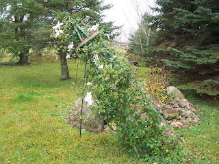
 Weeping Willow branches which flew and got stuck in our ash tree Oct. 27
.png)
.png)

 Local View
 Old fashioned Pink Thanksgiving/Christmas Cactus
 Yellow flowering Thanksgiving Cactus buds

 Front yard Compare photo Oct 24th 2009
.png)
.png) Local View
Local View
.png)
.png) Local View
Local View
 The warmest high was 86.F which was reported in River Falls and Hudson. The coolest high was 78.F reported in
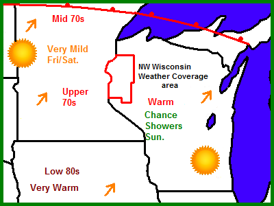
 Local View
 Cornfield with a forest of Oaks and poplar in the back round
 Understory Sugar Maples in the woods south of my house Oct 6
.png)
.png) Local View
Local View


 Local Map