Map Image Legend Image

Iowa Weather Network Warnings Map

Iowa Weather Network Warnings Map

Winter Weather Advisory

Sunday, February 27, 2011

Sunny skies with Normal temps returning briefly, but much colder again for Wednesday.

Regional View.

Average temperatures will return to the Upper Midwest this week for the first time in a few days, this will be experienced under sunny skies with no precip. It actually looks like a dry 3 days ahead for once, the only snow that may be found will be in Northern Minnesota, or on Wednesday with a sharp cold front that will pass through, this will also lower the temps drastically back to well below normal levels.


Local View.

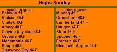
Locally we can expect, under sunny skies, what is supposed to be experienced for temperatures this time of year, which is the upper 20s to low 30s. Not only will we have normal warmth back it should be sunny both Monday and Tuesday, with Tuesday being the warmest of the sunny skies. I would not be surprised to see a few upper 30s. but this bout of normal temperates will only be brief as a sharp cold front brings us back to well below normal temperatures on Wednesday. with cloudy skies and flurries, highs will struggle to reach the upper 10s, which is more normal for January then the last day of February. lows will be in the teens Monday, and down to the single digits Wednesday morning, wind chills may become a slight issued Wednesday morning.

Monday, Warmer with sunny skies and calm winds with highs in the lower 30s. Monday Night, Clear skies, lows in the mid 10s.

Tuesday, Mild, Sunny skies with highs in the middle to upper 30s. Tuesday Night, Becoming cloudy, and turning windy, lows falling to the single digits.

Wednesday, Cold, Much colder with clouds early then clearing, breezy with cold wind chills and highs in the upper 10s. Wednesday Night, Cloudy with lows in the low 10s.

Looking Ahead

Anyone looking towards long term Spring-like weather will not find it here. Thursday following the cold air Wednesday looks warmer with a good chance at snow. possible some significant accumulations the way it looks right now. Behind this col and dry conditions makes a come back. Then just in time for my birthday March 8th, the models track a potentially strong snowstorm for the local area. Looks like it has a lot of moisture to work with so it would definitely bring significant snow, with highs winds and potentially blizzard-like conditions. Behind this storm storm, the models are showing significantly cold air being drug behind it, highs may struggle to reach the single digits above zero following that system. lows will be well below zero. Then towards the very end of the model it shows slightly warmer temps with snow making a come back into the pictures.

Tuesday, February 22, 2011

Brief warm up with light drizzle or light snow, then much colder with light snow Friday.

Regional weather view.

It will be a bit milder in here in the Upper Midwest the next couple of days as a weak system passes through Northern Minnesota, where minor accumulations are possible. temperatures as warm as the lower 50s are possible in snow less areas of central and southern Iowa. low to mid 30s everywhere else.

Local view.

A system passing to the north will give the local area a brief warm up Wednesday, but it will come with light snow or light drizzle. Accumulations of any snow would be light if any. Highs should reach the mid 30s Wednesday and cause some melting of the fresh snow. Thursday will be mainly cloudy with near fair temperatures for this time of February. Then on Friday we have the chance to see some light snow, this could accumulate up to an inch. Temperatures with this snow will be cold for what is expected for this time of year in the upper 10s, and lows falling to just above zero.

Wednesday, Mild with light drizzle or light snow. little if any new accumulation. Highs in the mid 30s. Wednesday Night, Cloudy with lows in the upper 10s.

Thursday, Cooler but fair temps, with Mostly cloudy to partly sunny skies. Highs in the upper 20s Thursday Night, Partly cloudy with lows in the low 10s

Friday, Cold, light snow possibly developing in the afternoon, up to an inch accumulation. highs in the upper 10s. Friday Night, cloudy with lows in the low single digits.

Looking ahead

Sunday into Monday immediately following the 3-day forecast looks interesting, I'm watching a potentially strong Winter storm, which looks to impact somewhere in the Upper Midwest, it looks to be possibly a big wind and snow producer. Then after Tuesday March 1st, It turns significantly colder, quite cold for early March standards. Then it turns slightly warmer, but still below average for the week of the 4th of March, then March 5th looks like slightly warmer and with snow chances. Then for March 8th it looks cooler and dry, with more snow chances for the the 9th. Overall it's showing a cool and snowy pattern. With no signs of any significant Spring warmth.

Monday, February 21, 2011

Feb 21st report.Historic Feb records broken- Sigificant accumulating snow for the entire area with Major accumulations in areas.

Very low visibility from heavy snow and blowing February 20th

Our 2nd Major Winter storm of the season left quite a bit of new snowfall across the area, with some impressive amounts as high 15 inches! All this new snowfall is thanks to a strong area of low pressure that moved from Nebraska to Iowa, The local area was on the cold side of the low which in most systems is where some of the heaviest snowfall totals can fall. Snow was very slow to start, but once it started it really came down and lasted for a very long time. This storm had it's own interesting characteristics, This storms preip band was very slowly moving and it's effects were actually isolated to the southern areas at first. At the same time I had just clouds and Strong winds, my brother in River Falls was saying they had heavy snow with 8 of new snow. Light Snow finally started falling around 2pm here, and just before sunset, a very heavy band moved up strait from Southern Minnesota, and it hit with force. It went from good visibility and wind, to heavy snow and significant blowing snow like in the picture above in the matter of 30 minutes. The same viable isolated in weather conditions was also noted at first between me and Siren I had 5" of snow with heavy snow and blowing snow while 40 miles North in Siren there was nothing yet falling.

Photo of the snow accumulation on the downwind side of our house

This system was quite impressive for February standards, many regional weather record for the highest February snowfall were broken. Including my 3-year record for the highest amount single snowstorm event in February. To note in how strong this storm was, my average snow for the month of Feb is 6.80" and I got 11.0" in this storm, which almost double the monthly average in one storm!

I would also like to mentioned that this storm also broke my 3 year recorded for the highest season snowfall accumulation which is now up too 67.90" In spite of my 3 year record, I have to say on a personal level, This is the most snow I've even seen in one winter here. the snow piles around my yard from plowing are nearly as high as the second story roof on our tin shed.
Very large snow drift.

This storm brought winds strong enough to bring some noteworthy drifts, which were 2-3 feet high, in many of the drift problem spots of the Dec blizzard of this year. Much of the reason for the very high snow drifts in this storm compared to that one was the previous high snow piles around made it easy for snow to accumulate, also winds were actually a bit stronger in this system compared to that one. My highest gust was 36MPH out of the ENE, which was recorded early in the storm system. Winds went down into the 20-30MPH range when the heaviest snow started.


Snowfall reports.

The highest accumulation was Menomonie with a impressive 15.00" Drift in this area could have easily been 4 feet. The lightest snowfall report seen was 5" out of Danbury.

Sunday, February 20, 2011

Major Winter Storm targeting our area Sunday 12-18" poss. Heavy, and blowing snow at times. Updated X1

Regional Weather View

A Major Winter Storm is targeting the Upper Midwest that looks very strong, will focus all attention. Major snowfall accumulations are likely to be widespread in areas of Northern South Dakota, Southern North Dakota, Western and East Central Minnesota and Western and East central Wisconsin. with the highest accumulation in central MN and Western WI here 20 inches is possible. South of there for far southern South Dakota, Minnesota, Northern Iowa and Southern Wisconsin could end out with either a significant sleeting event or possibly, an ice storm. South of that Southern Iowa will be warm enough near 60.F that they will see just plain old rain and thunderstorms!


Local View

A powerful Major winter storm is likely to hit the local area Sunday into Monday with very heavy snow major accumulations and very gusty winds. A low pressure system with plenty of gulf moisture will pass to our south in Iowa, and spread snow, heavy at times across our area. Snow will not start until the morning hours early Sunday morning. By sunrise, it should be snowing in all areas. Sunday afternoon the progression and strengthening of this storm will likely allow for snow to be heavy at times especially in mid morning afternoon hours, If convection forms close enough thunder snow would be possible. At this same time winds will strengthen and become strong out of the NNE, winds will be gusting to 35MPH at times, Which will causing significant cant blowing and drifting snow. Monday, especially early will not be much of an improvement. Moderate to heavy snow at times will still be possible, and the snow doesn't look to let up until Monday afternoon. Any wind left over would blow around the newly fallen snow. By Monday night things will finally improve, skies will clear and lows will fall into t he single digits. The good news is arctic air will not follow this storm and Tuesday temperatures actually will moderate some as we look towards sunshine and highs in the upper 20s and lows in the low teens.

Major Snowfall accumulations

Every Computer model I've seen continue to show very high snowfall totals across the area, due to the consistent updates, I've once again upped my expected amounts. This storm will be a dangerous winter storm, which will impact the entire area with significant conditions. The area I expect to see the highest totals will be south of the pink line on the map above, Here I've up the total to 12-18" For Southern Burnett/Washburn and Northern Polk/Barron counties I'm upped to 9-14" With 6-12" falling in the rest of Burnett and Washburn counties. Temperatures during most of the snow will be in the upper 20s to near 30.F with little temp changes at night, this would mean the snow will be heavy and wet in nature, The threat of falling tree limbs or power lines increases.

Sunday, Snow starting early Sunday morning, Becoming moderate to heavy at times in the morning after sunrise into the afternoon, Windy with blowing and drifting snow and winds gusting to 35MPH at times. Highs in the upper 20s. Sunday Night, A good chance of snow, Moderate to heavy at times, winds gusting to 25MPH, lows in the low 20s.

Monday, A good chance of snow early, possibly moderate at times, before tapering just after 12pm, Windy, north winds gusty to 25MPH at times, blowing and drifting snow. Total storm accumulations 12-18" south 5-14" north. highs in the low 20s. Monday Night, Cloudy, lows in the mid single digits.

Tuesday, Warmer, Partly Cloudy with highs in the upper 20s. Tuesday Night Partly cloudy with lows in the low teens.


Looking Ahead

The looking ahead forecast will not be released tonight due to focus being directed to this upcoming Winter Storm. I will mention though, another storm system-possibly another winter storm may cause issues by the middle to end of the upcoming week, but because it is still far away, it is way too early to tell if it will make impacts in Western Wisconsin.


Other blogs are covering this Major winter storm for there respective areas here is a link to there warning pages and forecasts.

Dirks Forecasting Center-Northwest Wisconsin

The Weather Den- Eastern Minnesota/Northern Twin Cities Suburbs

Tims Weather blog-Northeastern Minnesota-Northern Wisconsin

Friday, February 18, 2011

Sigificant snowstorm possibilties for late this weekend into next week. Early Release map

Early Release Regional View

Note this forecast early release is to give an early warning for a possible significant snowstorm in the coming days.

The forecast models are slowly coming together for what could be a significant snowstorm over the Upper Midwest Sunday into Monday. Right now the models favor West and East Central Minnesota and, East and West Central Wisconsin. This would include the entire local area, Right now it appears we have a good chance at seeing snowfall accumulations over 6 inches. Winter storm watches will likely be posted this afternoon. A detailed forecast concerning this storm will be issued this evening

Thursday, February 17, 2011

Warm Temp report for Wednesday Sigificant snowpack loss seen.

Snow free Grass showing in the front yard February 17th

We have ended the warm airmass, and now that it has ended it is time to do a final tally of reports. Thursday was not as warm as I expected it to be and since my report has to cover the warmest temps I will cover highs experienced on Wednesday the 16th. It was a partly sunny day, with very warm air surging ahead of a low pressure system. Most areas in these conditions reached there first 50s of the year, including at my location, which will be my new 3 year February record high. A few spots that had more sun warmed as high as the middle 50s!

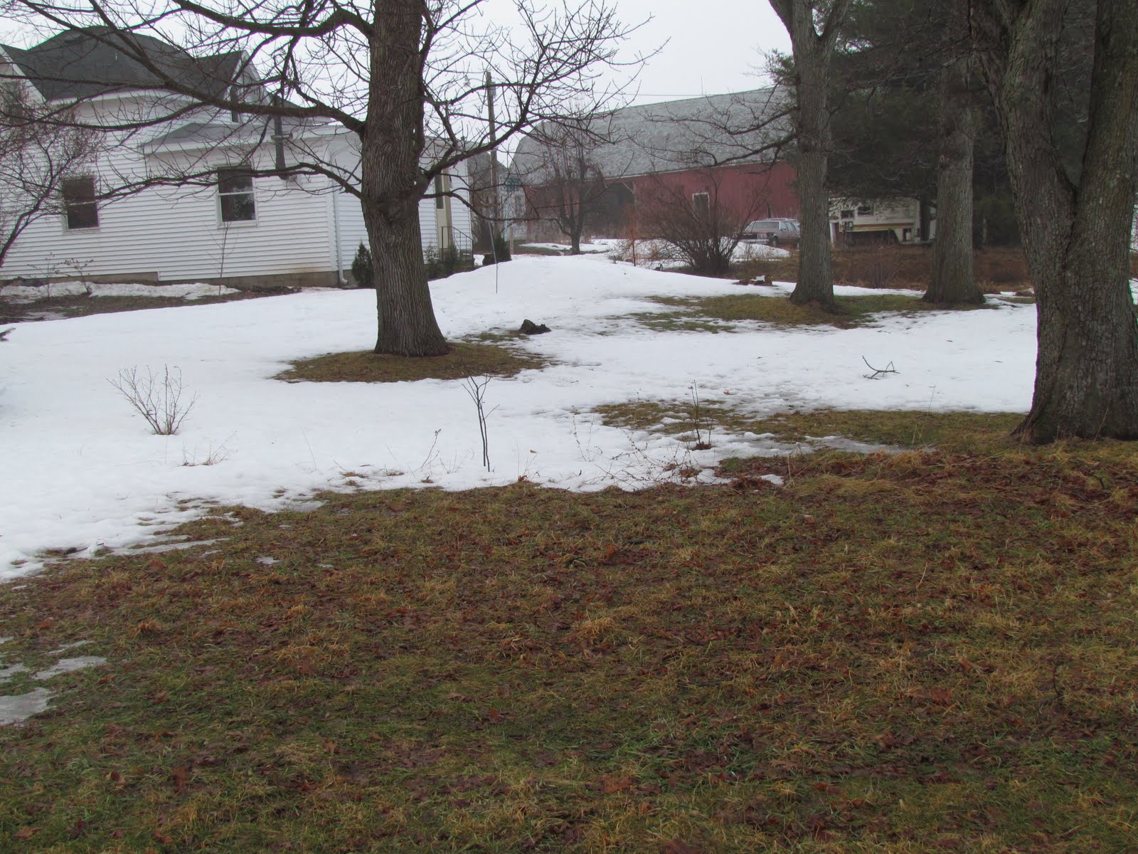
Snow cover before the big melt February 1st


After the melt February 17th

A significant loss in the snow depth was seen with this air mass, temperatures overnight from the 16th to the 17th were now even below freezing, they in mid 30s with drizzle This is when I feel we lost the most snow. I lost a total of 13 inches of snow, going from 21 inches to 8 inches by the ending of the warm spell. I feel 8 inches is a typical snow pack for this time of year! Many areas of grass can been seen in the yard, and even hilltops, This is the most grass I've seen in 3 months going back to mid November!


Highs reported Wednesday the 16th.

Highs on Wednesday were as warm as the mid 50s in Burnett County which had stronger sun showing through the clouds, areas they were held under a bit thicker cloud cover were a tad cooler. The warmest report was Grantsburg at 56.F, I had to look at that report twice, but both stations in that area recording this! The coolest report was Menomonie at 44.F

Wednesday, February 16, 2011

Very mild tomorrow, Near record highs possible. Then sigificant changes ahead. Much colder Friday and windy with flurries.


Regional Weather View

An extremely mild air mass for February will continue to be the rule at least through tomorrow. A very strong warm front will surge even warmer temperatures yet strait north from the southern U.S. Near record regional highs are possible as Middle 50s could be seen as far north as Minnesota and Wisconsin, 70s could be as close as the now snow less ground of southern Iowa. To go with this air mass fog an breezy southwest winds will be seen across the region. Friday will be the start of significant change for the Upper Midwest, a sharp cold front will sweep east bringing sharply colder temperatures, light snow and windy conditions for Friday and Saturday.
Local Weather View.

Tomorrow will be another beautifully mild day, which will start off cloudy with dense fog and drizzle in the morning Fog may be an issue early, then winds will pick up out of the southwest which should scour out the clouds and fog and drizzle. As skies clear highs will reach middle 50s under breezy southwest winds and partly sunny skies. I am going on a limb with a forecast this high, but I believe this warm front will be strong enough to bring temps this warm. Winds Thursday could approach 30MPH.

Sharply colder Friday

Thursday Night/Friday a sharp cold front will move through, winds will turn out of the NW and become strong, winds could gust close to 40MPH, temperatures will fall off drastically from what we've have been enjoying, a few wind blown few flurries will be possible as well, The wind will probably feel quite chilly to us. Saturday will be less windy, with partly sunny skies and highs in the upper 20s to 30.F This is actually not considered cold for this time of year, actually it is quite normal, lows will fall back into the low teens range.

Thursday, Very mild, Fog, some dense with drizzle in the morning, becoming windy, wind gusts up to 30MPH possible. Turning partly sunny in the afternoon with highs in the low to mid 50s. Thursday Night cooler, Cloudy with lows in the low 30s

Friday, Much colder and windy with wind blown flurries. Winds gusting to near 40MPH at times out of the Northwest. Highs in the upper 20s little to no new snow accumulation. Friday Night, Windy, partly cloudy skies with lows in the mid teens.

Saturday, Partly Cloudy and less windy, Fair February temps in the low 30s. Saturday, Partly Cloudy with lows in the mid 10s.

Looking Ahead

Sunday and Monday I'm watching what could be a developing snowfall event for somewhere in the Upper Midwest, It looks like someone maybe could get some significant snow, with rain but it is too early to tell where, right now it is trending southern Minnesota into southern Wisconsin as getting some of the highest snow totals, We will have to watch this closely if it looks to gain strength. Behind it in Tuesday it looks colder, with highs back below freezing. Then a gradual warm up, by Thursday the 24th the models are trending a second significant system, but this time it wants to put us on the mild side of it instead, which would mean another warm up and the potential for rain, before changing to snow and becoming sharply colder by Friday the 25th. Saturday The week of February 26th looks cold behind that system It remains chilly and dry through the rest of February. Then towards the end of the model run, the models are hinting at another warm up as we head into the start of March. More in this later.

From Drifts to Daffodils! + 1st 50.F at my location.


Sprouting Daffodils February 16th

The title of the post is correct. We went from large snow Drift to sprouting Daffodils all in a one weeks time. Today's high was 50.F at my location, the first 50 degree reading of 2011, but exactly one week ago on February 9th the high was 6.F! It did not take long with highs in the 40s and 50s the past 4 days to quickly melt the snow on the south side of my house and allow for the southern foundation daffodils to begin sprouting, I'm not that all surprised in the fact that last year I reported some February 18th, nearly the same time frame, but I am surprised that they are sprouting when were still in mid February, only 1 week past a daytime high in the single digits!

Gardens covered in very deep Snow cover Feb 1st
The snow cover really has taken a significant hit the past week as high temperatures have soured above freezing everyday for the past 5 days, 2 of them were near, if now surpassing 50.F My snow depth was 21.0" before this warm air mass came and as of 3pm today it has dwindled to 13.0 so we've lost 8 inches so far, but I'm expecting significant drop from this number as lows tonight remain well above freezing, and highs sour to near record highs tomorrow.


Sunshine and significant snow melt Feb 16th

Here is two photos showing the difference of how much snow has been lost, before this air mass hit, it looked more like the one above, when temps as warm as they have been this much of a difference can be created!

I'm expecting near record highs possible tomorrow, so expect more pictures of the melting snow pack, and more then likely a warm temperature report. My forecast for tomorrow and the upcoming days will be released shortly.

Sunday, February 13, 2011

Mild with weather continuing, mid 40s possible with sun again on Wednesday!

Regional Weather View.

The upper Midwest will continue to bask under the mild air mass which will remain entrenched over the region for the next few days, No significant precipitation will be found anywhere, just beautiful mid February weather.

Local View

Locally we can expect no end (at least for now) to the beautiful weather we've been experiencing just recently. Monday will be much cooler then Sunday was, but still warm for this time of year, It will be in the 30s, and there will be more clouds around. Tuesday a warm front that will pass south of us on Monday will return as a warm front Tuesday and bring us partly cloudy skies and warmer temperatures, I am going with lower 40s for Tuesday. Lows Tuesday night will only fall to the mid 20s, Wednesday will be very mild, with partly cloudy skies, I believe we have a shot at temperatures back into the middle 40s if not upper 40s, it will all depend on if fog forms Tuesday Night. At this point I believe fog will not be an issue until Wednesday night and I'm going with mid 40s. Lows Wednesday night will fall only into the 30s. Expect lots of melting snow and pounding of water on roads and in ditches this week, as we could loose over half our snow cover!

Monday, Mild & Breezy, with Partly Sunny with highs in the mid 30s. Monday Night, Partly Cloudy, lows in the low 20s.

Tuesday, Partly Cloudy and windy, winds gusting to 30MPH at times. Highs in the low 40s. Tuesday Night, Fog possible overnight, otherwise partly cloudy with lows in the mid 20s.

Wednesday, Very mild, Partly Cloudy with highs in the mid 40s. Wednesday Night, Fog and clouds developing, lows in the lower 30s.

Looking Ahead.

We get one more very mild day Thursday before significant changes can be seen. To end our very mild airmass we may have the potential for a developing snowstorm, it's too early to tell where and how much, but it has the chance of hitting the local area, possibly starting off as rain. Much colder weather follows behind it Saturday the 19th, it's back to highs in the 20s and lows in in the single digits. We dry out for the rest of the weekend, with fair February temps. Then Wednesday the 23rd the a possible strong storm system, with lots of snow passes just southeast of the area, it may be close enough to effect us with some good chances at plowible snow. It cools back off for the starting of the week of the 24th. Later that week to the starting of March, warmer and snowier weather moves in. This pattern shows a potentially active rest of February. In conclusion, people should not be getting used to the current nice weather, because it wont it sticking around, the good news is, there doesn't appear to be any more major arctic outbreaks on the long term forecast.

Warm Temperature Report- Most spots near 50.F today!


Beautiful Sunny skies February 13th

Today was a surprisingly very warm, and beautiful day, many locations had temperatures near 50.F for the 1st time in 2011 a couple spots even surpasses 50.F. What is surprising about this is it is only February and were only into our second month of the new year. I knew when I woke up this morning it was going to be very warm because already at 9:30 in the morning it was 35.F with partly sunny skies, and a very warm day it was, my location shot up to 48.F, with partly cloudy skies. This temperature of 48.F surpassed my 3 year February record high which was 45.F in 2008. Temperatures were slow to fall, even at this hour of the night ( 10:00pm) it is 42.F, which is very mild for a February night. The snow pack really took a huge hit today, I don't have official measurements, but we definitely lost well over an inch, I would have to estimate we lost at least 4 inches. Today was a great way to spend a day in February, after 44 days of below 32.F or colder temps, and one heck of a snowy start to Winter. Also seen in the area today was the 2011 first rain showers, some weak showers moved through in the evening and gave me the first rain of the year, but it was light and only a trace.


Temperatures Reported February 13th.

Some spots did reach above 50.F today, Baldwin was the areas warmest report with a high of 51.F and the coolest reports were 46.F which as can been seen were reported at many locations. With this temperatures, it is almost easy to forget it was -13.F only two days ago!

Thursday, February 10, 2011

Thursdays Temp Report

A Arctic looking scene caused by more then a month of below freezing temperatures, and weeks of strong cold winds.

A arctic air mass parked it's self on top of the local area this morning and brought 20 below zero readings once again to parts of the area, under clear skies temperatures quickly dropped due to a arctic air mass and clear skies.


Low temperatures reported Thursday Morning.

The coldest reading was in the traditional cold spot in Minong where they had a very cold low of -26.F, the warmest reading was my station which only fell to -13.F I'm continuing to be surprised by the huge temperature differences that appear sometimes between my and other stations I am in an continue study taking temperatures around my house, I'm started to find out some interesting facts, one is that the biggest difference is only when it is calm winds. I'll release more on this later when I'm done taking measurements.

Warmer times ahead with flurries Friday, Then Spring-like airmass moving in for Sat/Sun. Updated X1


Regional weather view
Note: this map has been updated to show Saturday weather conditions, expect warm front will be past Wisconsin by this time.

A warm airmass will be moving into the Upper Midwest from the west, bring and early dose of Spring-like temperatures, and will finally give the region a break from this Winter which has been a cold and snowy one. The only chance at precip will be from flurries Friday along the warm front.

Local View.

Note: Sundays forecast has been changed slightly due to strong wind that will pick up.

Locally we will get a nice break from this winter as a warm Spring-like airmass moves in for the weekend. Friday will be mostly cloudy with a chance at some light flurries, or maybe even some freezing drizzle with the passes of a warm front. Any accumulations of freezing drizzle or snow will be light. Saturday will be the start of a string of mild days coming our way. It will be partly sunny with highs reaching the low 30s, and possibly getting above freezing for the first time at most locations in more then a month. Lows Saturday will be very mild up into the low 20s. Sunday will be very nice if we don't get above freezing Saturday then we definitely will Sunday We will have, clearing skies highs will reach the middle to upper 30s and lows in the mid 20s. It will be a weekend to get outside for sure.

Friday, Mostly cloudy with a chance of freezing drizzle or flurries, little if any accumulation. Highs in the upper 20s. Friday Night, Mostly cloudy a chance of flurries with lows in the low 20s.

Saturday, Partly Sunny and mild! light winds with highs in the low 30s. Saturday Night, Partly Cloudy with lows in the low 20s

Sunday, Partly Sunny with clearing skies. Windy, winds gusting to 35MPH at times, with Highs in the mid to upper 30s. Sunday night, Clear skies with lows in the mid 20s.

Looking Ahead

Our mild air mass doesn't stop there, we look to remain mild and dry through the middle of next week with highs reaching near 40 everyday! We even may have a shot at mid 40s maybe even 50.F degree temperatures late next week. Wednesday and Thursday looks especially warm. Friday looks a little cooler with a chance of light snow, or freezing drizzle. Then Saturday colder air moves in, but not significantly cold. Then it warms back up for the weekend of the 20th, a chance snow is there as well, possibly more significant. Behind it colder air moves in, but temperatures quickly moderate back to very warm levels as we approach the middle to end of February, snow chances look to increase towards the end of the run as well. So the models continue to hint at a warm and snowier pattern setting up.

Wednesday, February 9, 2011

Trip to Rochester,Minnesota.

Downtown Rochester,Minnesota February 8th

I went to Rochester,Minnesota this week to visit the collage there and to see what they had to offer. We left late Monday and staid over night Monday night into Tuesday. Weather when we left Wisconsin was cold and sunny, and it remained cold and sunny as we made our way south into Southeast Minnesota.. In Rochester it was cold and sunny the entire time we were there, but it was colder back at home. My station had a low of -14.F while Rochester had a low of -11.F on Tuesday Morning.

After seeing and touring the collage in Rochester, I've decided I want to pursue a horticulture technician class, which focuses on putting my education towards learning about trees,shrubs and plants and landscaping. The class is a 2 year course, I would like to start by this Summer in August. During the time I move and will be going to school, there will be huge changes here at my blog. I have not decided completely what I want to do but, I will either change this blog to focus on covering my weather experiences and end forecasting, or I may continue forecasting and change my blog to cover counties in Southeast Minnesota. I've even thought about continuing my coverage of forecasting in Western Wisconsin. I will discuss and continue to think about my plans for my blog over the next few months, but for now I plan to continue to provide full coverage to the area and I'm expecting a very busy Spring and Summer here at my blog.

Saturday, February 5, 2011

Warm with drizzle or snow Sunday, Turning much colder for Monday and Tuesday.

Regional Weather View

For once there will be no significant weather happening regionally. We will be dealing with a warm and cloudy air mass Sunday then colder air will make a come back for Monday and Tuesday some places could get some light snow Sunday but nothing significant will come from it.


Local View

Locally we will be dealing with fog from melting snow out at least through Sunday, some light freezing drizzle will be possible Sunday as a cold front begins to make it's way south any accumulations would be light. Temperatures will be in the mid 20s Sunday before they begin to fall off Sunday Night to the mid 10s. Monday will be much colder and a bit breezy with flurries as the colder air mass moves in. Highs will be in the mid to upper 10s. Monday Night clouds will begin to clear off as a high pressure moves in, lows will be a bit hard to forecast but cold none the less, with clear skies low will fall to the low teens below zero. Tuesday will be cold with arctic sunshine, highs will be in the low teens, and lows in the low teen to single digits below zero. Wind chill may become an issues Monday Night through Tues.

Sunday, Mild and cloudy with fog early, freezing drizzle or light snow possible through the day, but especially early, light accumulations if any. Sunday Night, Colder, cloudy with a chance of light snow, lows falling to the mid teens light snow accumulations.

Monday, Colder, Cloudy with highs in the mid 10s and a chance of light snow, light accumulations. Monday Night, Partly cloudy and Cold lows falling to the teens below zero.

Tuesday, Cold with arctic sunshine and cold wind chills, highs in the low 10s. Tuesday Night, Partly Cloudy, cold with lows in upper single digits to 10s below zero.

Looking Ahead

Out of out next arctic air mass which will start on Tuesday (above) Wednesday looks the coldest, lows approaching -20 in spots may be possible. Arctic sunshine with dry conditions last Friday the 11th. Then Saturday starts the trend of what could be a warmer but snowy weather pattern. The forecast model show a chance of multiple systems with snow one looks especially strong around the 18th colder and drier conditions follow this by Monday the 19th but warmer, and snow chances move right back in at the end of the model run on the 20th.

Tuesday, February 1, 2011

Cool Wednesday, but a warming trend begins Thursday with light snow moving in Friday, light accumulation.

Regional Weather View

A Major Winter Storm which crippled parts of Iowa and Illinois will continue moving east Wednesday, some blowing an drifting snow will still be possible in that area tomorrow morning as the storm moves east. Farther North, it will be cold with arctic sunshine over Minnesota and Western Wisconsin. Friday a new weak system and warm front could bring some light snow into the region with only light accumulations, temperatures will be mild come Friday due to the front.

Local View

Locally we can expect to see some arctic sunshine for Wednesday, highs will be not too bad for this time of year in the 10s, with lows under clear skies falling into the upper single digits to low 10s below zero. Thursday skies will be partly cloudy with increasing cloudiness as the day goes on, it will be warmer with highs in the low 20s. Friday a warm front and system will bring in some light snow chances with light accumulations in inch or less appears likely at this time. some freezing drizzle may also be possible near the warm front. Temperatures as a result of the warm front will be in the upper 20s with lows remaining in the 20s.

Wednesday, Arctic Sunshine, a bit breezy early with highs in the low 10s. Wednesday Night, Partly cloudy with lows in the 10s below zero to upper single digits below zero.

Thursday, Partly Cloudy with increasing clouds. Highs in the low 20s. Thursday Night, Cloudy with lows in the upper 10s.

Friday, Cloudy with a chance of light snow, light accumulations at an inch or less possible. Highs in the upper 20s. Friday Night, A chance of light snow or freezing drizzle, lows in the mid 20s.

Looking Ahead

Saturday and Sunday following Friday look quiet bit cloudy and fair temperatures. Monday a storm that will have to be watched could track through the Upper Midwest and bring some plowible snow parts of Minnesota and Western Wisconsin, it is too early to tell how much and if that track is solid. Behind this system a fairly good dose of cold air follows for Tuesday lasting through Thursday. Then towards Sunday the 13th, the models are attempting to hint at a possible significant warm up, with maybe some chances are rain, but this could only be temporary and it could change. Tuesday the 15th it shows a good chance of snow for us with cooler conditions. Towards the end of the model run it shows continued chances at snow with warm winter conditions More on this later.