Downtown Cresco June 25th 2013
Howard County Fair Forecast
The Howard County Fair is this week into the weekend from Wednesday the 26th through Sunday the 30th. The following is a weather you can expect for the fair activities.
Fair goers can expect a fairly good end of the week for the fair with the expect of only 1 or 2 storm chances. Thunderstorm chances on Wednesday will give way to sunny skies for Thursday and Friday of the fair. It will be rather nice accept that the winds will be on the breezy side out of the northwest. Temperatures will be typical for this time of year with much lower dewpoints. Saturday has a chance for some rain in the form of showers and thunderstorms, but at this time the chance is somewhat low and it doesn't look like an all day rain. Temperatures will cool into the upper 70s with the cloudcover Saturday. Sunday it turns pleasant behind a cool front, skies will become sunny once again and temperatures will be pleasant and not to hot with highs in the mid to upper 70s
Wednesday: Thunderstorms in the morning then skies turning partly sunny, humid with high temperatures in the lower 80s. Wednesday Night, Cloudy skies, humid, lows in the middle 60s.
Thursday: Warm and Sunny, breezy northwest winds to 30MPH, highs in the mid 80s. Thursday Night: Clear skies, lows in the middle 60s.
Friday: Sunny skies, breezy northwest winds to 30MPH, highs in the lower 80s. Friday Night, increasing clouds, lows in the lower 60s
Saturday: Partly sunny with a chance of rain, Highs in the upper 70s. Saturday Night, Decreasing clouds with lows in the lower 60s.
Sunday: Sunny with light winds and pleasant temperatures in the middle to upper 70s. Sunday night, Clear skies, lows in the upper 50s to lower 60s.


Iowa Weather Network Warnings Map

Winter Weather Advisory
Tuesday, June 25, 2013
Friday, June 21, 2013
June 21st bow echo, severe winds, hail and flooding. Minor wind damage and 1.00" hail seen at my location
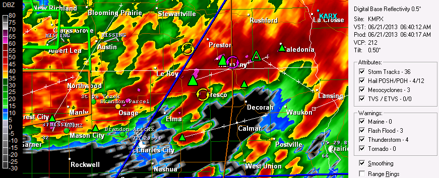
Radar shot as storms moved thorough North Iowa June 21st 2013
A line of severe thunderstorms commonly called a now echo impacted the entire area early this morning and brought widespread strong winds, isolated spots of hail and torrential downpours and flash flooding across the local area. Thunderstorms first developed in South Dakota late Thursday afternoon and formed into a bow echo that crossed the state of Minnesota in a southeasterly direction from the Twin Cities area around 2am. Storms continued to follow a stationary front and by 5 to 6am the bow echo re cycled and strengthened as it moved into the local area, but especially after crossing the Iowa boarder where rich dew points in the lower 70s were seen storms were seen.
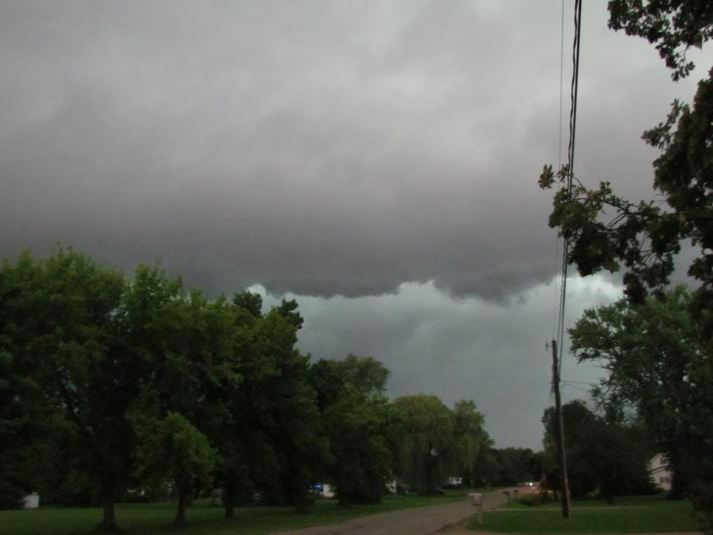
Cloud line from early morning storms June 21st 2013
The bow echo first enter the area in Olmstead, Dodge and Winona counties where it did spotty wind damage around Rochester and throughout the 3 counties. As the storms pasted Rochester they strengthened about the point where they reached Austin were spotters reported power outages and trees down. The storms crossed the boarder into Iowa, Here in Cresco, Iowa we had quarter sized hail and wind damage in the form of several medium sized 6-10" diameter branches down. The storm went on to produce wind damage around Decorah and flash flooding as well as locations father south and east before exiting our area shortly after 7am.
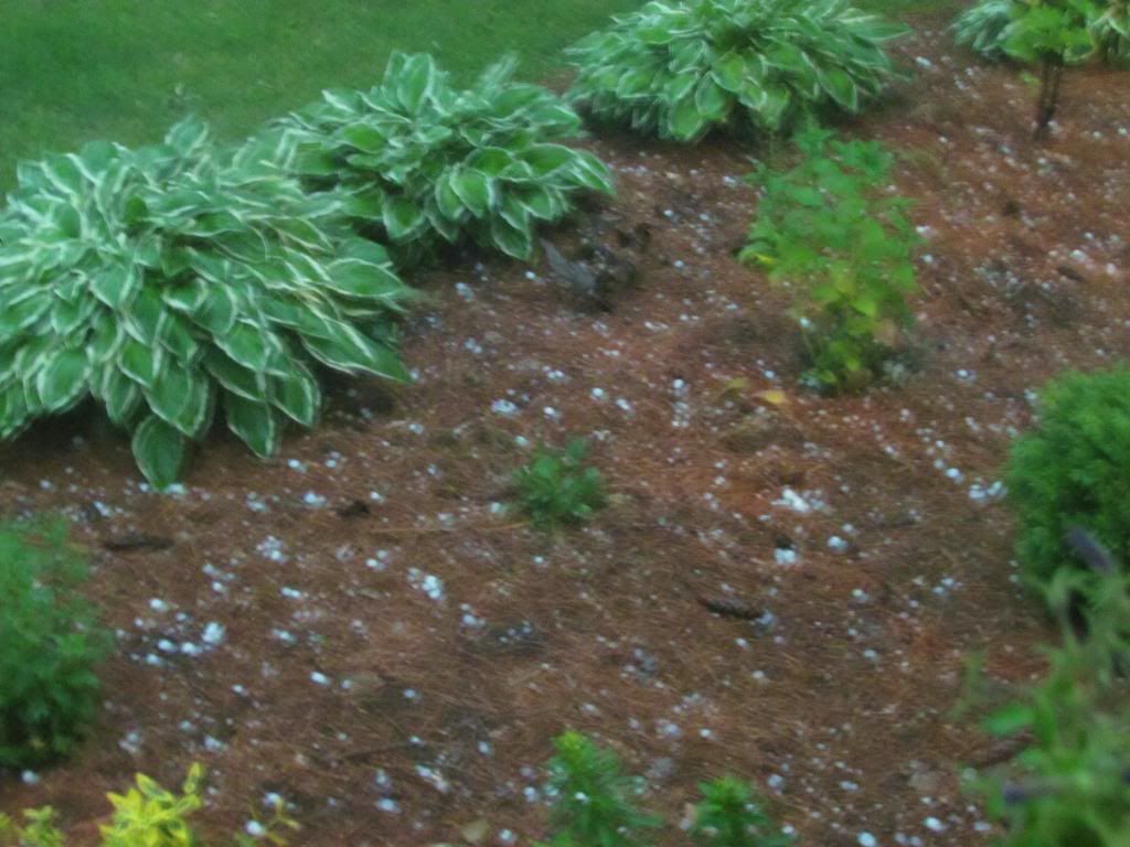
Hailstones June 21st 2013
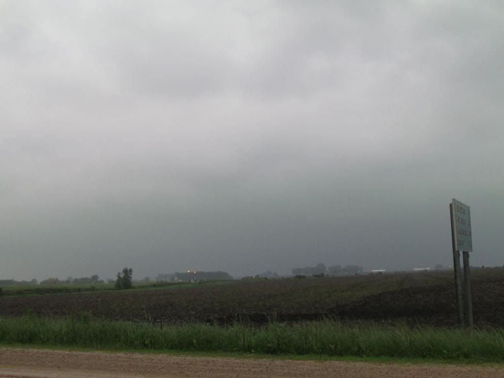
Here in Cresco the storm was singled by very dark skies, dark enough for the city lights to turn back on as the storm approached. I could see a rolling cloud line with green skies behind it ( photo above) and as the line moved in winds began to pick up from the north. Strong north winds continued especially as the heavy rain came down. At this point in the storm a video can be seen below. I estimated the winds were around 50MPH then after 5-6 minutes or so, quarter sized hail began falling, some of the hailstones looked slightly larger then quarters making it the biggest hail I've personally seen. Torrential rain followed this hail heavy enough that it was difficult to see very far. Damage mostly in the form of several large branches could be seen down across the city including in my own lawn. Many of them snapped high up in the tree and did not fall
Video of the strong winds as the storm moved into Cresco,IA June 21st 2013
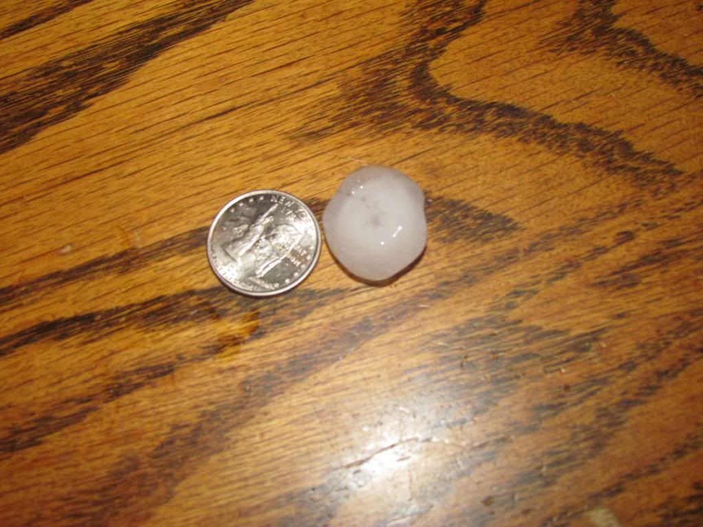
Hailstone from my yard June 21st 2013
This hailstone is slightly large then a quarter. I kept this hailstone and put it in my freezer. The hail fell for about 1-2 minutes and quickly started to damage garden plants but it did not do much damage as it did not last long.
Tree limb snapped high up into a tree in my backyard June 21st 2013
Reports
Decorah,IA 3.00" of rain Flash Flooding Reported in the city
Decorah,IA Trees down
Genoa,MN Mud slide reported on highway 35
Rochester,MN quarter sized hail, Trees down in NW Rochester
Austin,MN Tree down on powerline causing power outages
Cresco,IA Tree limbs down, quarter sized hai
Thursday, June 13, 2013
June 12th Severe Weather Report. Damaging Winds and large hail reported locally
Video of strong winds from a storm in New Hampton,IA June 12th.
Some residents of the area are dealing with damage from a round of severe thunderstorms that developed yesterday afternoon evening both in Southern Minnesota and across North Iowa. The cause of the severe weather was an usually strong low pressure system and stationary front which both were situated just south of our area. This along with muggy dewpoints in the 70s and a twist in the atmosphere was the perfect set up for an explosion of severe thunderstorms. Local NWS offices were so concerned a PDS ( partially dangerous situation ) tornado watch was issued for most of our area.
Region Reports
Across the region was a very active day not only for our area but several areas of the 2-3 state area. An area of the central part of Iowa had tornadoes including several close calls for a least 2 large Iowa Cities including the Waterloo-Cedar Falls and Dubuque areas, Luckily there were no touchdowns in those populated areas. One storm produced a tornado causing significant damage to the town of Belmond,IA where NWS employees will be surveying the damage today. Other tornadoes did major damage to residents near rural areas near Hampton. Another line of severe thunderstorms produced significant wind and hail event for Southern Minnesota in the Mapleton Albert Lea Areas. Severe weather was also seen in Illinois and east at the same time as these rounds were going on. North Illinois including the Chicago metro dealt with high winds causing damage in that area.
Storm in New Hampton looking southwest towards the strongest part of the storm towards Nashua.
Several storm complex moved through different areas at different times yesterday evening. Most of the tornadic activity stayed to our south as our area dealt with storms producing high wind hail and torrential downpours. One storm complex moved southeast out of Minnesota across southwestern parts of our area. Damage was reported in Charles City, I went to chase this storm and ended up in New Hampton where I saw high winds and heavy rain in the video above. The worst part of this storm pasted to my southwest. Other storms complexes developed some remained just torrential downpours and did not become severe, while others became severe. A storm that produced golf ball sized hail in Fillmore County Minnesota developed off the outflow boundry of storms developing in Howard and Winnishiek counties. A 3rd complex of damaging wind storms developed in North Central Iowa and produced another round of severe winds for southwestern parts of the area for the 2nd time this day. Nora Springs was the hardest hit towns yesterday with numerous trees and power lines reported down. Torrential rains from storms repeatedly going over the same areas coupled with an extremely wet spring caused major flooding of the Shell Rock River with numerous roads being reported washed out in the Nora Springs area with flooding concerns now being seen for the Charles City area
Local Storm Reports
5 miles S Whalan golf ball sized hail
Charles City, Trees down in the city
Nora Springs 59MPH measure wind gust
Nora Springs, Numerous trees and power lines down
Nora Springs-Flash Flood Numerous roads impassible or washed out, water to the top of the levee
Tuesday, June 11, 2013
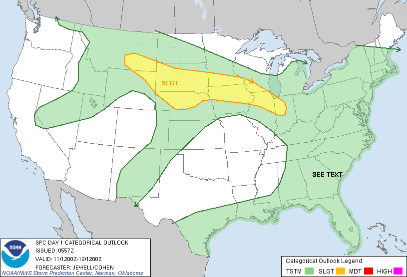
Severe Weather Risk Tonight
Image from SPC
The threat for severe storms exits tonight as thunderstorms will develop along a frontal boundary currently set up across the local area. Thunderstorms will first develop over areas of South Dakota this afternoon and moved east along the front through the rest of the evening. The storms will not reach our area until well after dark into the early Wednesday morning hours, so you can expect that all of Tuesday will be warm and humid with no weather effecting the day. Severe storms move in around 11pm-4am tonight. All types of severe weather is possible but the main threat will be enhances chances strong damaging winds and heavy rain. SPC says the Southwestern parts of our area along the Minnesota/Iowa boarder including Charles City, Austin and Le Roy has an enhanced threat for the storms being severe, but all locations have at least some risk. Be on the look out for this storms anytime after dark tonight.
The threat for severe storms exits tonight as thunderstorms will develop along a frontal boundary currently set up across the local area. Thunderstorms will first develop over areas of South Dakota this afternoon and moved east along the front through the rest of the evening. The storms will not reach our area until well after dark into the early Wednesday morning hours, so you can expect that all of Tuesday will be warm and humid with no weather effecting the day. Severe storms move in around 11pm-4am tonight. All types of severe weather is possible but the main threat will be enhances chances strong damaging winds and heavy rain. SPC says the Southwestern parts of our area along the Minnesota/Iowa boarder including Charles City, Austin and Le Roy has an enhanced threat for the storms being severe, but all locations have at least some risk. Be on the look out for this storms anytime after dark tonight.
Wednesday, June 5, 2013
Current weather condtions and forecasts and interesting facts
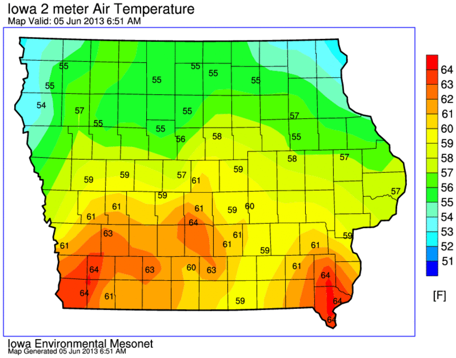
Image from Iowa Environmental Mesonet
Starting off this morning with current temperatures we have the warmest conditions taking place in the southern part of the state where it is currently in the middle 60s. The coolest conditions can be found in the northern part of the state where temperatures are 10 degrees cooler in the middle 50s. Currently across the area it is 53.F here in Cresco with fog and clouds. In Rochester its 53.F with the same fog and clouds and in Charles City it is 55.F with fog and clouds.
Interesting weather facts-Our Area
Rochester,MN This past spring was the wettest on Record for Rochester and the 7th coldest also making it the coldest since 1996
Dodge Center,MN NWS confirms that last months snowstorm total of 15.40" in Dodge Center will be the new state 1 day May total snowfall record for the state of Minnesota
State of Iowa-
Mason City ( NWS Des Monies )- Mason City has received 22.76" of precipitation so far this year. which amount is 9.59 above normal in order for this area to fall below normal it would have to stay dry through the 4th of August
State of Minnesota-
Minneapolis/St Paul 15.69" 4th wettest Spring on record with temperatures 1-3" degrees below normal on average.
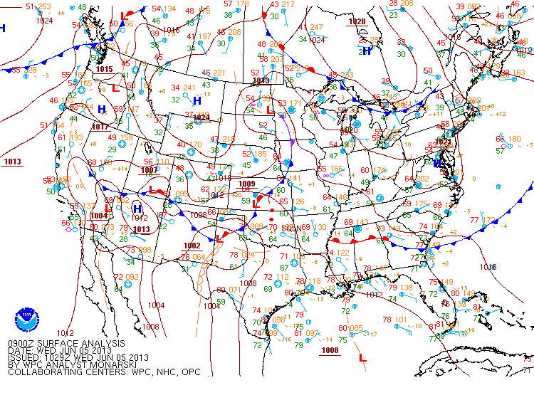
Image from NWS
Currently we have a frontal boundary sitting across Iowa and Minnesota, this is the same boundary that lead to yesterdays rainfall amounts, which by the way were generally around 0.75" of and inch to 1 inch across the region. This frontal boundary will move east by 3pm this afternoon which should lead to overall at least clearing and warmer temperatures rising to near 70.F. There will be a chance of morning showers and possibly a thunderstorm. Overall this week it will be cool and on the wet side. Temperatures will be warming up but they will be much cooler then where it should be this time of year, we can expect highs in the 60s and then slowing warming into the 70s by weeks end, lows will warm up into the 50s and 60s. We should begin to see the sun at least at some point Friday and Saturday.
Thursday: A chance of light rain and drizzle in the early part of the day, otherwise cloudy with highs in the upper 60s, Thursday Night, A chance of drizzle, otherwise cloudy with lows in the upper 40s to lower 50s.
Friday: Warmer, Partly Cloudy with full cloudiness from time to time, a few scattered showers, Highs in the upper 60s to lower 70s. Friday Night, Partly Cloudy, lows in the low 50s.
Saturday: Mostly Sunny, highs in the lower to middle 70s Saturday Night, Showers and Thunderstorms developing late. Lows in the upper 50s.
Sunday: Showers and Thunderstorms, Partly Sunny with highs in the middle 70s.
Monday: Sunny and Nice. Highs in the mid to upper 70s. Monday Night, Clear skies, lows in the upper 50s.
Tuesday: Increasing cloudniess with a chances of a few showers or a thunderstorm late. Highs in the upper 70s. Tuesday Night, Showers with a chance for thunder, lows in the low 60s
Wednesday: Thunderstorms likely, some possibly strong, otherwise cloudy with highs in the upper 70s. Wednesday Night, thunderstorms early, lows in the lower 60s.
Looking Ahead:
Looking ahead the models want to at least give a hint of it becoming somewhat drier and warmer in the long term. Next weekend of the 15th it looks dry, sunny with near seasonable temperatures. The next chance of rain comes early into the week of the 18th, Monday will have a chance of some rain, it looks light at this time. Wednesday through Friday
Monday, June 3, 2013
May 31st flooding, Severe thunderstorm and reported tornado in the Floyd area.
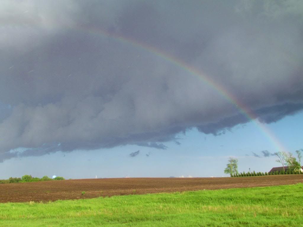
Rainbow on the back side of the Floyd Tornado storm cell. May 31st Lime Springs,Iowa
The area was again rocked by several waves Severe Thunderstorms Friday May 31st, this time as a sharp cold front pushed through the area. The front was a slow moving front which allowed for multiple waves of severe thunderstorms to develop 3-4 waves to be exact. The first storms of the day developed in Northeast sections of the area and became severe outside of our viewing area. Another lone cell later developed and produced a tornado near Floyd which caused tornado warnings to be issued for Howard County. The cell was very weak and the tornado it produced was small and brief. Numerous funnel clouds were reported in the Southwest part of Howard County before the storm quickly dissipated. After seeing the warning go out I chased the cell to Lime Springs, the tornado was already dissipated by this time but a nice cloud formations could be seen on the back side of the storm. The second and 3rd line of storms developed on a cold front much later in the evening right along the cold front. Thunderstorms exploded into a broken line over Southeast Minnesota near Austin and Rochester and quickly becoming severe producing hail and 57MPH in southern parts of the Rochester metro. There was one tornado warning for Olmstead County but nothing produced. These storms were more of a hail, high winds and torrential rain event. Later during the evening more storms developed southwest into Iowa as the line filled in, but the storms developed and re developed for at least 2-3 hours over the same area of Mitchell County causing flooding near St Ansgar. Eventually the storms pushed east across the rest of North Iowa, but were weakened by that time to below severe thresholds.
May 31st storm reports
Southern Hills ( Rochester Metro) quarter sized hail 57MPH wind gust
Predmore quarter sized hail
7 miles SE Rochester golf ball sized hail
2 miles SW Eyota quarter sized hail
Le Roy quarter sized hail
St Ansgar quarter sized hail
Carpenter Flash Flood- Water starting to go over nearby roads
Subscribe to:
Posts (Atom)

