Were looking at another weather system coming at the Upper Midwest starting Sunday in SD, and Western Minnesota. Then moving east Monday. Minnesota, Western Wisconsin and Northern Iowa will have the threat for Severe Thunderstorms. then Tuesday things clear out.
Local View Updated for Tuesdays Weather.
Hot Weather Tuesday.
Things clear out, and dry out Tuesday, But it now appears like station front will not give us relief from the warm humid conditions. Temperatures will actually by Much Hotter on Tuesday as Highs will approach 90.F, Dew points will still be quite high across the local area this will cause Heat Index to get close to the 100s range. People in the area should take measures to Stay cool tomorrow
Tuesday, Clearing, Hot and Humid! Sunny, highs in the upper 80s to lower 90s. Tuesday Night. Clear Skies, lows in the mid 60s.
Looking Ahead.
The Weather Pattern is finally showing signs of calming down, but things will continue to stay hot, We could get near 90 multiple times between Tuesday through Friday. It also looks like it will be preip free, with lots of dry days. It does show a slight chance at rainfall come time next weekend August 7th and the 8th. Otherwise, The models seem consistent with another Hot air mass heading our way starting the 6th, and getting really strong by the 8th. then it shows some dry days during the week, then then Sunday 13th models show some rainfall chances with cooler conditions. More on this later.
A Picture of the massive storm front at my location July 27th. (looking West)
This post will be separated into 2 parts. one part will cover the storms in the area as a whole, and the second part will cover the storm and damage at my location.
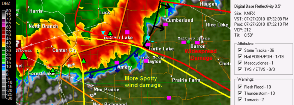
A very Large Line of storms extending all the way from Northern Wisconsin to parts of Nebraska pushed across all of the 6 county area Tuesday. with reports of a lot of Wind Damage, including some significant strait line wind damage, and some damage that was from a tornado. The main damage area seems to be centered around the Balsam Lake, Turtle Lake and Almena areas north to Cumberland, with lesser wind damage south.
GRl3 radar image with narrative lines (Pink squares are damage/Strong wind reports) Large image Here
This line of storm first developed in Minnesota, producing wind damage across the Northern Twin Cities Metro, It weakened slightly, then really bowed out as it reached St Croix Falls, When it bowed out it started producing significant wind damage. A small brief tornado dropped and effected the Village of Balsam Lake, knocking down trees and signs the tornado was rated EF-0. This significant wind continue East to the Cumberland, Turtle Lake and Almena east to Cameron taking down trees power lines down and even causing structural damage just north of Turtle Lake, It was confirmed that a tornado passed just North of the Village of Turtle Lake, This tornado ripped siding off homes and destroyed sheds and roofs, it was a confirmed EF-1 A 3rd EF-1 tornado was confirmed north of Chetek (full list of reports at bottom) As the radar suggests above, the strongest winds seem to be where the tip just west of Turtle Lake starts and it continues North from there, Winds in the area could have been between 60 and 70MPH. with a 2 tornados, one in Balsam Lake, and the other near Turtle Lake. Winds appear to be less extreme south of this area with gusts as high as 45 to 50MPH effecting places like Amery, Clayton & my location, Clear Lake, Star Prairie and Deer Park into Northern Dunn County.
Tree damage in Turtle Lake Photo by Alan Gabe.
The Community of Turtle Lake just to my north got hit very hard with this storm. My friend reported that there was trees and power lines down in and around Turtle Lake blocking roads, as well as siding torn from parts of a the hotel on the West side of town Highway 63 near Turtle Lake was closed due to fallen trees. with the tornado passing less then 2 miles from town to the North and Northeast the damage to this area was more significant.
Storm at My Location
Second Image of the Storm front (Looking North towards Turtle Lake)
This line of storms brought Very Strong winds to my area, The strongest winds that I have seen in many years. As the storm came in, I could see a massive storm front ahead of the storm, and in all my years of storm photography i have never seen a wall of clouds above the storm front like this. I could tell by the looks and speed of these clouds, and radar images that the winds were going to be very strong, but it wasn't until Damage reports came in from Balsam Lake before I realized my home and community was in danger and people needed to be inside, because this storm reminded me a lot of the strait line wind event of June 2001 This is one last image of the storm clouds showing just how threatening the skies looked, I've never seen this much green in storms before!
Storm Footage of the strongest winds.
I decided I was to film the winds from our poll shed on the Northwest side of the yard so I could get full view of the trees, but I was glad the winds were not much stronger then they were, because the shed started to rattle under the strength of the winds. I seen the strongest winds came just before the rain hit, just as the huge shelf cloud in the pictures above pasted, It went from dead calm to windy like in this video in the madder of minutes. Video still of the Backyard tree enduring the strongest gusts Est. at 50MPH
During the strongest winds, Me and my family all thought the tree in the photo above would fall at any moment, the winds were pushing on the tree like never seen before causing cracking and creaking. But thankfully this old ash tree made it through another storm, and we were glad it did because had it fallen, it would have fallen right onto our house. The Strongest gust picked up on my anemometer from the WNW at 39MPH, but my gauge was unfortunately partly blocked by a tree, but I would estimate winds were near 50MPH at my yard with 48MPH gust was reported just to my west. After the the strongest gusts, some wind continued some but really died down after the heavy rain moved in. I picked up 0.70" of rain in the storm, This storm also had vivid spider web-like cloud to cloud lightning.
Damage at my yard
Branch damage all over the backyard the next day July 28th.
The Damage from this storm was on the severe storm threshold side in my yard, but I was surprised there was not more significant damage because of the high list of damage reports just north of my community. Scattered live and dead Branches were down all over my backyard, one branch measuring 1 inch in diameter
Torn Shingles in the yard.
The WNW winds were actually strong enough to tare shingles off of our garage roof, a building that has nothing blocking it from the West. The shingles were found thrown across the yard past our apple tree! but thankfully there wasn't more then a few that were torn off.
This is a small poplar tree that was blown down just to the WNW of my house, This tree was 4 inches in diameter. There was also a lot of grass completely flattened just west of my yard in the fields. This will be a storm me and many more across the area I will remember for a long time, I seen many things in this storm I've never experienced before.
Damage Reports
Balsam Lake, Garage Damaged, trees up to 5 inches in diameter down.
ConfirmedEF-0 Tornado effecting the Village of Balsam Lake.
7 miles N Range, Large pine tree toppled
Turtle Lake, Large trees down onto power lines near intersection of Highway 8 & 63 Highway 63 closed due to down trees
ConfirmedEF-1 Tornado effecting rural areas just North of the Village of Turtle Lake.
2 miles S Cumberland, Pine Trees Snapped house with half of roof torn off, Trees down on houses.
2 miles NE of Spooner Large Tree down on cabin.
6 miles S Cumberland, Trees Down
Birchwood Large pine tree fell on cabin and made hole in roof.
2 miles N Turtle Lake power lines down
2 miles N Stone Lake Power lines down
Balsam Lake, 53MPH wind gust
6 miles W Trego several trees down
Amery 48MPH wind gust
1 miles SE Clayton Tree 4 inch in diameter and branches down, shingles torn off garage
2 miles E Barron Trees Down
1 mile W of Barron Trees down, power lines down.
ConfirmedEF-1 Effecting rural areas 2 miles N of the City of Chetek.
This is a temporary post. The Storms tonight have done some widespread wind damage to the local area especially in Polk and Barron Counties. Widespread Tree damage was reported in Cumberland, and Balsam Lake, with widespread tree and power line damage as close to me as Turtle Lake 5 miles to my north where Trees. The Winds blew very strong at my house, but surprisingly, my immediate yard seems to have escaped with no damage, but I have not done much traveling around due to lightning. A More detailed post with pictures, videos and damage reports will be released once I survey more areas around my house for storm damage. I will have the post out likely during Monday Afternoon.
The Storm Prediction Center in Norman,Oklahoma Continues a Slight Risk of severe thunderstorms across much of Minnesota, and Western, Northern, and Central parts of Wisconsin for This Evening. This risk has a highlighted area of 30% of Hail and Wind which covers Eastern Minnesota and Western Wisconsin. Thunderstorms should fire to the north of the local area in the afternoon and move East southeast and will become severe. The main threats at this time appear to be very large hail and damaging stait line winds. People in the area should continue to stay tuned, as we have an increasing severe weather threat for this evening.
A strong cold front and System will move Southeast across Minnesota tomorrow. Setting the stage for a Hot Day across the Upper Midwest. And a active day. Severe Weather is possible in Minnesota and Wisconsin. Things will clear out and become dry again by Wednesday.
Local View.
Locally we are looking at a Hot and Very Humid day to start off the day Tuesday then ending the day with strong thunderstorms. High Temperatures will likely top 90s across much of the local area, but best chances will be South of the Burnett/Washburn county line. and with Dew points in the 70s, It will feel like nearly 100.F so it will be a Hot one before the storms hit.
Severe Weather Risk
It is certainly looking like we have severe potential with this system. Right now it looks like storms may be ongoing in Northern parts of Minnesota possible effecting Burnett and Washburn counties in the morning. Some of these if they hold together, could be strong. then things will clear out shortly in the afternoon and it will get hot. Then in the evening, storms will form in Minnesota and move into Wisconsin along a cold front. Very large hail, and strait line winds will be possible, but there may also be an enhanced tornado threat. Heavy Rainfall will also be a possibility. Best chance of storms at this time appears to be after 6PM
Wednesday and Thursday we will be enjoying cooler temperatures a much drier air mass with sunny skies. Expect 80s with lows in the 60s.
Tuesday, Hot and Humid. Highs topping 90.F chances of Thunderstorms early north, then a good chance of thunderstorms in the evening. Some could be severe. Highs in the low to possible mid 90s, Heat Index's near 100. Tuesday Night. A chance of Thunderstorms early. Some could be severe, otherwise clearing with lows in the mid 60s
Wednesday, Clearing Skies. Cooler, More comfortable. Sunny with highs in the low 80s. Wednesday Night. Clear, Lows in the upper 50s.
Thursday, Sunny Skies. Mild Temperatures highs in the low to mid 80s. Thursday Night. Clear lows in the low 60s.
Looking Ahead
By Friday Rain chances may be moving back into the picture. But for now that looks slight. by Wednesday August 4th. The models show a warm-up with more rain chances moving in from the west. Then by August the 8th, It shows a better chances of rain with continued warmth. By the end of this short run, it continues to show warmth, with off and off rain chances, which has been what the models have been showing for the past week.
We continue to have wet weather across the Upper Midwest, and it looks like this pattern will continue. A low pressure system and stationary front will continue to be the focus for showers and thunderstorms across Minnesota and Wisconsin. There will be a sharp cut off in temperatures as highs sour to the lower 90s in Iowa, but only make the upper 70s in Northern Minnesota.
Local View.
Locally, We will continue that chance of showers and thunderstorms Friday and early Saturday, but Sunday we will really start to clear out. A Stationery Front will cause some stormy conditions. Highest chance for rainfall appears to be Friday Night, into early Saturday. Temperatures will be warming up and will be much warmer Friday compared to Thursday as the front gets closer, I also really believe we will have a least some more sun both days as well. There appears to be at least somewhat of a chance for severe weather with this system Friday Night, but it is too early too tell how much of a risk we will have. Sunday looks great, with sunshine and dry conditions with highs in the low to mid 80s
Friday, Partly Sunny, A chance of Thunderstorms late. Highs in the low 80s. Friday Night. A good chance of Showers and Thunderstorms, Some could be strong, possibly severe. Lows in the low 60s
Saturday, a chance of Showers and Thunderstorms early, then clearing. Highs in the upper 70s Saturday Night. Clear lows in the upper 50s.
Sunday, Nice! Dry, and Sunshine though out the day. Highs in the low 80s Sunday Night, Clear, lows in the low 60s.
Looking Ahead.
It looks like our dry streak will continue into Monday, with warming conditions possible getting hot towards that time. Then Tuesday through Wednesday looks mainly dry, with even warmer condition's. Thursday looks dry but Friday the 31st looks as though there may be a chance of rain. It also looks cooler for this time. Before it warms right back up for August, stormier conditions will also begin to start. By the end of the run it looks cooler, and rainy.
The SPC has moved the slight risk out of Minnesota and Western Wisconsin for this afternoon. Still, there may be a few storms that produce heavy rainfall. but the main severe weather threat has diminished for today.
Wall Cloud just west of my house, over Clayton July 20th
Severe Storms were again a part of the weather today, as storms tracked over parts of Polk and Barron counties that produced wind damage, even some significant hail along with structural in a few locations.
The first storm started out in Northeast Polk County and tracked Southeast over Northern and Eastern Barron County. It started producing severe hail at Mckinley in Polk County where 1.25" hail was reported. This storm started producing severe winds by the time it reached just east of Cumberland.some significant roof damage was done to a barn east of Cumberland. At this point the storm became very strong right before hitting Rice Lake. Rice Lake reported hail 1.75 in size, with trees down in parts of the city. One report southeast of Rice Lake even came in at a 2.50 inch hail. This storm continued to produce severe hail as it hit Canton, before moving out of the local area.
Video of the wind in the storm at my location.
The second storm hit Polk County, from the Northwest portion, through the central, part to the southeast part. This storm effected my location. It started out becoming very strong just south of Grantsburg, It moved southeast and hit places such as Milltown and Balsam Lake. Half dollar sized hail was reported in Balsam Lake, This storm then hit Range where A funnel cloud was reported, The storm continued southeast and had Clayton right in it's path. From my view, I could see a non-rotating wall cloud that moved just west of my house, so about over Clayton. a video of the wall cloud can be seen here. The storm also had intense cloud to ground lightning strikes, with thunder immediately after the lightning. I had one very close strike just North of my house. Hail in my yard, taken well after storm.
Shortly after the rain and hail started, Most of this hail was dime sized, but some were up to nickel sized, and the hail didn't last long. After the hail, the wind hit, and blew strongly from the Northwest, Then as quick as the storm came, it was gone. There was no damage in my area from wind, and only minor damage from hail, I did see a few leaves in the trees get stripped. Strongest wind gust was 25MPH from my gauge and 0.27" of rain.
Radar Image showing how after the storm hit Range, The center of rotation passed directly over Clayton, which can be seen as the small curve in this image. I did hear the sirens going off in Clayton for this storm, which they normally don't sound for severe thunderstorm warnings, but the county must have though this situation was special enough to sound it, I do believe it was a very close call, things could have been much worse in Clayton.
Beans with Hail Damage Between Clayton and Range just off County Road D
Shortly after the storm was over at my house, I got a call from my friend who said there was some fairly significant tree damage in Range, a small community about 4 miles Northwest of Clayton. I got a ride with him to go view the damage and I was surprised what I saw, The damage started at the Clayton Township Hall about 2 miles away from Clayton, and continued to get progressively worse as we headed towards Range. Cornfields in this area were stripped to almost nothing, Hail 1.75" in size was reported in this area.
Road covered in leaves in Range.
As we gone into Range, we could see shredded leaves, as though someone put trees in a blender and threw it on the road. There were large trees in the road, that has been removed before we got there.
Tree down in Range
There were multiple trees, and large portions of trees down in Range from this storms, even smaller ones in the photo above came down.
The oddest part about the damage was how this portion of a tree ended up in a power line, I still could not think of any way how this would have happened. This photo was taken Range
Damage Reports
Rice Lake area storm
1.25" hail Mckinley.
4miles SE Rice Lake 2.50" hail
Cumberland, Funnel Cloud.
4 miles E of Cumberland, Turkey barn roof blown off.
Rice Lake 6 inch diameter tree blown down
Canton, 1" inch hail.
Polk County Storm
1.25" hail Balsam Lake
1.75" 2 miles SE of Range
Range, Funnel Cloud.
0.88" hail Clayton
Wall Cloud, Clayton.
Image from SPC
The SPC has issued a Slight Risk for severe weather this afternoon for parts of Wisconsin. Stroms will devlop near a through, some of which could become severe. Main threats are hail, and very heavy rainfall.
An active weather pattern continues for the Upper Midwest. A series of weaker storms systems will keep shower and storm chances alive off and on the next 3 days. It will become increasingly humid as the days progress, and temperatures will rise.
Local View.
Locally, It will not be all day rain. They will be isolated brief showers of thunderstorms in the afternoon hours Tuesday, if anything develops. If nothing developed it will be partly cloudy with fair temperatures. Wednesday will be nice, it looks like it will be sunny, with highs in the 80s. Thursday looks like the better chance of showers and storms. A warm front will start to get close which will bring that chances for rain, It does not appear like this will be severe at this time but things could change. It will also be becoming humid by Thursday, dew points will be near 70. Highs in Thursday if the rain holds off till afternoon will be in the mid 80s.
Tuesday, Partly Cloudy, with the chance of an isolated shower ot Thunderstorm. Highs in the low 80s. Tuesday Night, Partly Cloudy, lows in the upper 50s to low 60s.
Wednesday, Nice! Sunny, highs in the low 80s. Wednesday, Clear, lows in the low 60s.
Thursday, A chance of Showers and Thunderstorms in the afternoon. Becoming Humid. Highs in the mid 80s. Thursday Night, A chance of Showers and Thunderstorms. Lows in the mid 60s.
Looking Ahead
The End of the week looks fairly stormy, the models show a system with potentially heavy rain Friday, but then it quickly drys out by Sunday Monday July 26th looks Hot and Dry. then more rainy conditions, move in by Thursday the 29th. Then the models are pointing towards a drier pattern as we leave the last days of July and Enter August. It continues to appear like it will be warm. more on this later.
Video showing the lightning show this storm had the evening of July 7th, Sirens can be heard in the back round.
Storms hit the area once again during the evening of July 7th, With several tornado warnings across parts of the central area, and damaging winds south of this area. A line of Intense strong storms developed in Minnesota, where they caused a lot of damage in the Northern Twin Cities Metro, These storms continued to move east, although they weakened some at this point they crossed the border, there was an area in this line with strong Rotation, and earlier in the evening a tornado was reported. The went through Southern Polk County. Where a Tornado Warning was issued, I was starting to get concerned because of it's range from my home, but thankfully, there No tornado's or funnel clouds were reported , and the center of rotation passed to the South of Clayton on Highway 63 between Clear Lake and Clayton. South of this area A line of a strait line winds hit, with Winds as high as 50 to 65MPH in Extreme Southern Polk County, through all of St Croix county and Western Dunn County. The storms continued to weaken as then left eastern Dunn County.
A Video Still Image taken from the lightning in the video above.
This storm has no significant effects at my house, other then the fact that it had very vivid lightning, with bolts that shot across the sky, and some heavy rain, with breezy conditions.
GRl3 Radar Shot of the storm over Amery.
I did see low clouds to my Northwest that look a bit scary for a time, but it was dark and hard to determine if was rotating or not, In total My gauge report 0.75" of rain in the storm which lasted about 30 minutes. The highest wind reported from my gauge was 19MPH, this included a field gauge I has put out, A few miles to west in Amery, their station recorded a 43MPH wind. Another video of the storm can be found here when the storm was a bit closer.
Unfortunately, people who were hardest hit this time just dealt with severe weather last Wednesday!
Another strong weather system will drag up Hot weather for the Upper Midwest Saturday, Widespread 90 degree temperatures are expected from Wisconsin and Minnesota south. Severe Weather is also likely across the Upper Midwest. for parts of Minnesota and Wisconsin, and Northern Iowa.
Local Weather view.
Saturdays Severe Weather Potential
Saturday does have an increased risk for severe thunderstorms across the local area, Even though Minnesota will have the main severe weather, with a low pressure and cold front, the system warm front will be parked very close to the area, storms will form along this front, and some may become strong to severe. The storms will develop in the evening, and some may produce heavy rainfall.
Temperatures Saturday will also be very hot, and could reach their highest levels of the year, along with this conditions will be very sticky with high dew points. Some heat index's may approach the middle to upper 90s.
Sunday and Monday
It clears out Sunday and conditions will become nice. We will have a break from hot humid weather both days with highs near 80.F and sunshine, with low dew points.
Daily forecast below.
Saturday, Sunny during the day then increasing clouds. Hot and Humid, gusty winds from the south. then Thunderstorms developing in the afternoon, some may be strong to severe, and produce heavy rain. highs in the lower 90s. Saturday Night. A chances of thunderstorms, some could be strong to severe. Lows in the mid 60.
Sunday, Cloudy at first then clearing. Highs in the upper 70s. Sunday Night, Clear lows near 60.F
Monday, Warmer, Sunny, Dry, highs in the low 80s. Monday Night, Clear lows in the low 60s.
Looking Ahead.
The rest of the early work week looks increasingly warmer from Mondays highs. especially by Wednesday. Highs could be near the 90s once again. by the time we reach next weekend, we have out next storm chance. then Friday looks Dry, and Hot. Warm July conditions, with off and in thunderstorm chances continue all the way through July 31st go get ready for continued storminess with hot weather.
The Storm Prediction Center in Norman, Oklahoma has issued a Moderate Risk! for parts of the Upper Midwest for Saturday. This includes Western parts of my 6 county blog coverage area. Thunderstorms are expected to develop late and impact the local area after dark. The boggiest threats right now are very large hail, damaging strait line winds, and the threat for a tornado. People should Stay Tuned to local NWS for a possible second severe weather outbreak Saturday even into Saturday Night
Image of clouds from a severe storm on a storm chase I was a part of, at the 4 Corners, just south of Deer Park during the 3rd evening wave.
A Significant severe weather outbreak occurred Wednesday across Western Wisconsin, caused by a strong weather system, with a strong warm front that was parked just southwest of the area. Many people in the area are dealing with damage from multiple waves of severe storms that moved through, some communities even had up to 2 severe storm with damage roll through in one day, these storms that left widespread tree damage, flooding and even some structural damage across many local counties.
The first wave came from a line of severe wind storms that swept through the Northern areas, this line developed a southern flank that effected Northern Polk and Barron counties, which later came tornado warned north of Turtle Lake, These storms brought widespread severe winds, and very heavy torrential downpours, Widespread reports of trees down came in from many communities in Burnett and Washburn Counties, and a few across Northern Barron County. The storm did have some rotation, enough to issue a tornado warning for Northwest Barron County, in the Turtle Lake/Cumberland areas, but no reports of a tornado came in, but trees were reported down in the City of Cumberland.
Photo taken from the roof of my house of a storm with rotation in the 1st wave just to my north.
Because this storm was so close to my north, I went on the roof of my house to see if I could see anything tornadic, I did not see anything that looked like a tornado, but I could see lots of low clouds and very dark-almost black skies with thunder.
St Croix County Morning Storm.
During the morning, south of the main wave that hit Burnett and Washburn Counties, one single storm formed in Central St Croix County, This storm did severe wind damage Northwest of Hammond, which did some structural damage to a couple of homes in a housing development and blew trucks off Interstate 94 near Baldwin, along with many trees downed in this area.
2nd afternoon Wave effecting Eastern Polk, Barron, St Croix and Dunn Counties
Picture of the green skies from the second wave in Ellsworth,WI
The second waved formed right over Polk and St Croix Counties behind some morning spot showers, this waves quickly developed into a severe line with damaging winds, and torrential downpours that produced flooding. I was on a storm chase with a friend from Minnesota which lead me Ellsworth,WI during the second wave, It was easy to tell there was a warm front because when we got to Ellsworth from Clayton, it was extremely humid, dewpoints were nearly 80.F! In Ellsworth, we were hit with torrential rain, and strong winds, We took shelter at gas station in town. When the storm was over and we were on our way, I saw a large mature pine tree on a house down the street from the gas station we were at. This line of storms continued east and did tree damage throughout St Croix and Dunn counties, in Menomonie, significant tree damage was reported along with power out in parts of the city, Trees were also reported down in Woodville and Boyceville. This storm also had torrential rains, some places picked up over 4 inches of rain! My brother told me Barron had water 3 feet deep on city streets, he said it was so bad, he had to pull over to prevent the car from shutting down. Flooded Streets was also reported in the city of Rice Lake.
Second Wave at My location.
Plants blown off our table from strong winds
The second wave of storms effected my house, but we were lucky, we only had minor damage. the storms developed just west, and were developed into a full line by the time they reached Clayton. My family said we got strong Northeast winds, which only did some very minor damage in my yard, but took trees down along Highway 63 2 miles Southwest of Clayton. When I came home, I saw all the houseplants on the north side of the table thrown onto the ground. One of these weighing about 10 pounds was thrown a couple feet from the table, a sign that the wind had some strength. I was very surprised to hear that the winds were from the Northeast in Clayton, when the storms came out of the southwest, I am still unsure why the winds were out of this direction.
Image of a tree branch with yard stick for measurement.
I also had this tree branch down when I came home, it measured 1 inch in diameter, and about 6 and a half feet in length. My wind anemometer measured at 30MPH gust on top of the roof. but I was not home to put the field gauge out, which would have been less effected by trees. My family also said we had Extremely heavy downpours, which were so heavy it was hard to see the shed across our yard. My rain gauge said we got 1.19" in about 30 minutes of time. and when I came home after the storms, There were large puddles near the side of the road at the baseball field in Clayton.
3rd Evening wave, effected St Croix, Dunn and southern Barron counties.
The 3rd storm formed in St Croix County well after the 2nd wave was over, This storm produced some large hail, funnel clouds, and severe wind. Funnel Clouds were reported in North of River Falls and Hammond, Trees were reported uprooted in the community of Hersey East of Woodville. also, hail over 1 inch in size was reported near Dallas, and shortly after quarter sized hail was reported in Chetek.
Many people will be spending the rest of the week cleaning up from these storms, but thankfully, there was no widespread significant home damage. Many local forecasters said if the sun would have remained out longer, the severe weather situation would have been far worse.
Damage Reports
1st Morning wave
4 miles E of Grantsburg Trees Down, winds estimated at 60MPH
Webster, Large Oak Tree blown down.
Webb Lake, 10 inch diameter Oak tree blown down
Minong, Widespread Tree Damage with trees snapped or blown over.
Trego, Trees down across Washburn County, especially in Trego area.
Cumberland, 1 inch hail
Cumberland, Tree down blocking both lanes of highway 48
2 miles NE of Hammond, Garage Destroyed and roof taken off house
Rice Lake, Water 1 foot deep and intersections
2nd Afternoon wave
Woodville, Tree Limbs down.
2 miles SW Clayton, a few trees down along Highway 63
Baldwin, 2 semis blown off Interstate 94, also trees down in the area.
Menomonie, Many Trees down in North Menomonie
2 miles SW of Menomonie trees down onto power lines.
The Storm Prediction Center has issued a Moderate Risk! of severe weather for Wednesday for Eastern Minnesota, and Western Wisconsin, including the entire 6 county area. A strong low pressure and cold front are expected to moved across the region, after morning clouds clear, storms could fire along and ahead of a cold front in the afternoon and evening, if this happens the storms could very well become severe, and possible turn out to be a large outbreak, Right now the threats are, very large hail, damaging strait line winds, and possible strong tornado's, This outlook includes a 15% risk of Tornados as well as a 30% chance of wind, this is one of the larger severe weather chances we've had this season. People in the area should pay close attention to the weather forecasts for Wednesday.
Sunny skies can be expected across most of the Upper Midwest Monday and Tuesday, but Attention with weather is turned to a system that's expected for Wednesday which could bring severe weather, potentially even widespread severe weather to much of the region starting in North Dakota, South Dakota and Western Minnesota on Tuesday/Tuesday Night, spading east into Easter Minnesota and Wisconsin on Wednesday.
Local View.
Tuesday we can expect nice, pleasant weather, which many people will be glad for, I know I am because I start my first day at my new job! anyway we can expect sunshine and highs in the 80s, It will be getting increasingly humid during the day.
Wednesdays Severe Weather potential
Wednesday, although still a little far out, really needs to be watched for our local area, depending on a few factors, we could be dealing with quite a severe weather outbreak if this set up right. Right now it appears like Storms fire on Minnesota and move east. this could create a wind threat, but if storms develop closer to the area, we could instead be dealing with a tornado/large hail threat, along with wind. I will continue to monitor this through Tomorrow, stay tuned for updates.
Thursdays, behind the cold front it will become night again, but a bit on the warm side. 80s, with sunshine can be expected, with lows in the 50s to 60s, it could be breezy.
Tuesday, Nice, Mow your yard if you have the chance! sunshine with fair temperatures in the 80s. Tuesday Night, Becomeing Humid, lows in the mid 60s.
Wednesday, A chance of storms early in the morning, some could be strong, then clearing and becoming hot. Then developing thunderstorms in the afternoon, some could be severe and have heavy rainfall. Highs in the middle to upper 80s. Wednesday Night, Chances of storms early before ending. then clearing lows in the upper 50s.
Thursday, Nice, possible clouds early otherwise sunny skies with highs in the low 80s. Thursday Night, Clear lows in the low 60s.
Looking Ahead.
We wont be getting much of a break from the heat, because hot weather comes right back at us by Friday, Saturday and Sunday, only this time it appears like it will be sticking around. Highs could reach 90+ degrees, especially on Sat. Sunday does show some thunderstorm chances in the afternoon. then for Monday, Tuesday and Wednesday we will continue to be in a warm, humid pattern. Mid 80s could be expected most days, with a few shots at 90 once again. Saturday the 24th we could get a break from the heat, only for it to return by Sunday. Then the models show things really heating up come near the very end of the run. So get ready for hot & humid times ahead. More on this later.
My photo of a Storm front as a storm approached my yard from the North.
This is the second time this week the area dealt with strong storms and warnings. Strong to Severe Thunderstorms effected the area this afternoon, many thunderstorms warnings were issued, including a tornado warning in Washburn county. Storms developed along a cold front and moved southeast, first starting off in Burnett County and Northern Polk County, then spreading southeast, effecting my locations and other places in Dunn and Barron Counties.
Burnett/Washburn County: Many small cells formed from near Siren to Northwest of Spooner, some of these came strong, particularly one that hit southern Burnett County. A severe thunderstorm warning was issued for hail and 60MPH winds, This storm effected mainly places south of Siren, later on a report of some wind damage near Falun, East of Grantsburg. There was another storm that became possibly tornadic in Washburn County, The storm that caused a tornado warning was a small cell to the west of Spooner, Law Enforcement reported a tornado, but no damage came in from this area, so it's no known wither it was actually just a funnel cloud.
Polk/Barron County:
Radar shot of the storm that effected Polk/Barron Counties.
The storms that effected these counties started off as the storms in Burnett County that moved Southeast and back-developed into Western Polk County, They moved South and were primarily and produced very gusty winds, very heavy rain and some hail. This storm effected every community south of Highway 8, but was strongest in the Amery, Clear Lake, Clayton/Turtle Lake areas, just before reaching these areas, a Severe Thunderstorm Warning was issued for 1 inch hail and 60MPH winds. The storm continued East southeast and hit Praire Farm and Dallas in southern Barron county. a report of quarter sized hail was made from north of Amery with this storm, No wind damages report were yet entered.
St Croix/Dunn County: The storms that effected St Croix County developed very quickly, just north of Baldwin, This storm was a hail/heavy rain producer. and effected Baldwin, Woodville and Wilson. Quarter sized hail was reported in Baldwin with this cell. The same line that effected Polk/Barron Counties, it continued to produce heavy rain and very gusty winds, it hit places such as Ridgeland, Wheeler, Boycevill and Colfax. No reports of hail, or damage we reported in this county.
Coverage of the storm at my location
Video of the very gusty winds and heavy from the storm in my yard.
This storm was quite intense when it hit, one of the windiest storms I've seen for quite some time. The clouds before this storm started out black, and the closer the storm came, the more scary-looking the clouds got! At one point when I took the picture at the top of this post, I saw a shelf cloud with a greenish-tint below it, a sign that the storm was strong! After the shelf cloud passed, I could hear a loud deep roarer in the distance from wind and heavy rain. Soon after, I started getting strong wind gusts from the north almost a bit northeast with heavy rain, the temperature dropped over 10 degrees shortly after, going from 77 to 65! In the video above, the small tree near the middle of the screen was taking quite a beating from the winds, I was starting to get concerned it would snap, but it pulled though. Some very small branches, were blown down, and many of my my houseplants, even some big ones were tipped over. There was no hail at my yard, and no tree damage anywhere nearby, My wind anemometer on top of the house picked up a 32MPH gust. I also got some fairly impressive rainfall totals, picking up 0.91" of rain in this storm., This is the second time in a week that I've gotten a strong storm. here is one last image of the huge thunderheads as they were moving away
Storm Reports:
NW Spooner, Tornado reported by law enforcement.
Falun branches down.
N Amery 1 inch hail.
Baldwin 1 inch hail.
Turtle Lake, Heavy Rain, Torrential Rain with standing water at some street corners.
The Storm Prediction Center in Norman,Oklahoma has issued a Slight Risk of Severe Thunderstorms for much of the Upper Midwest, including my entire 6 county blog coverage area. Storms are expected to form along and ahead of a cold front during the afternoon and evening hours North of the area and move Southeast. Some of these storms will be strong to severe, with the main threats being strong damaging winds, hail, and the small threat for tornado's. Very Heavy Rain will also likely be an issue. People with plans this evening should be aware Severe Weather is possible this afternoon and evening.
The Storm Predication Center in Norman,OK has issued a Slight Risk which includes all of Western Wisconsin this afternoon. Storms could develop in Minnesota or Western Wisconsin this afternoon or tonight, some of which may become severe. At this time, the biggest threats are large hail, damaging winds and the small threat for tornado's. People in the area should stay closely tuned to there weather radios this afternoon should anythingdevelop and become severe.
Weather is looking pleasant for the ending of the work week, but it will be turning more humid with storm chances increasing by Sunday, parts of ND,SD, and Western Minnesota have severe potential Saturday, then this area shifts east into Eastern Minnesota, Western Wisconsin and Iowa by Sunday.
Local View.
We should get 2 more dry days before the weather takes a more stormy turn once again. temperatures Friday will be in the 80s, with lots of sunshine, and lower dew points. Saturday we will get increasing humidity and temperatures. If we get sun, I wouldn't be surprised if some places got near 90 once again, We should be dry Saturday, with partly cloudy skies. We will have increasing clouds in the afternoon. Sunday Thunderstorms look to develop at some point in the day, as a cold front approaches, at this point it appears some of the storms in the local area may become strong to severe, so this will be something to watch as Sunday gets a little closer, Otherwise, highs Sunday will be warn in the 80s and humid. Daily Forecast Below
Friday, Pleasant! Sunny with highs in the low 80s Friday Night, clear lows in the low 60s.
Saturday, Turning Humid, Partly Cloudy with highs in the mid to upper 80s. Saturday Night, Humid, lows in the mid 60s.
Sunday, Humid with a chance of Thunderstorms developing in the afternoon, Some could become strong to severe. Highs in the low 80s. Sunday Night, A chance of Thunderstorms, some could be strong. lows in the low 60s.
Looking Ahead
After the storm chances Sunday, We appear to go into another break from the rain. Monday through Thursday and this point looks dry, not necessarily sunny, but it should be dry. It also appear that Wednesday and Thursday of next week could be warm ones, highs may be near 90. by Friday the 16th, the models are picked up on a possible system, which could bring heavy rain to the area. Then it looks a little quieter for Saturday and Sunday, before we get hotter more stormy conditions once again by Monday the 19th. Even by the end of the run it continues to show Warm to Hot conditions with off and on storm chances.
Shelf Cloud from a Strong Thunderstorms which later impacted my house.
After a Hot and very Humid afternoon, Strong Thunderstorms hit parts of the area this, Especially in Northern St Croix County and Southeast Polk County, where this storm impacted me. Snapped Radar Image just before the heaviest band of rain hit my location.
Following the St Croix/Polk County storm in particular, it first started out in Northern St Croix County, it then crossed into Polk County, and moved Northeast following a stationary front. This storm really started to get together and become strong as it approached Clayton, At one point the radar was detecting possibly over 1 inch sized hail, This is when the NWS Issued a Severe Thunderstorm Warning for Clayton and the surrounding areas. but shortly after the storm weakened some. Other heavy thunderstorms hit Eastern Barron County and parts of Dunn County, There were no severe weather reports from any of the area, including southeast Polk County.
Effects that this storm had at my location.
Video of the Strong Winds from my Front Yard July 7th.
The storm hit me just before 6PM, about 5 minutes before the storm hit the NWS issued a Severe Thunderstorm Warning for my area. This storm, although not reaching severe limits severe was definitely a notability strong one in my book. A well formed shelf cloud could be seen for miles before it hit, the clouds went very fast from west to east. The rain was so heavy I actually could see the sheet of heavy rain moving down the county blocks southwest of my house in the distance. First came strong WSW winds, and extremely heavy rain, My field wind gauge clocked in a 27MPH gust. (This was about the time I took the video above) After the winds slowed the hail started, which came in 2 waves that didn't last very long. The hail was mainly pea sized, but some of it was just under the size of dimes, There was some damage to some of my garden plants, but nothing significant was done. This storm also came with frequent dangerous lightning, one bolt was extremely close, and had very loud thunder, enough that it shook the house and rattled the windows. I estimated the bolt hit a tree in the woods just across a thin field to my south, which is about quarter mile away! This storm also dropped a very heavy amount of rain in a short time, I picked up a quick 0.63" of rain, which fell with in a 10 to 15 minute time span! I was so heavy that our driveway had ruts carved down it. This storm was the strongest to impact me so far this year, and will be one to remember.
This storm brings my monthly total to over 2 inches, My confidence is getting higher that we will soon be completely drought free!
The Storm Prediction Center has issued a small risk of severe weather, which is 5% chance or less, which includes most of Wisconsin, Southeast Minnesota and Iowa. Thunderstorms are expected to develop this afternoon along a stationary front, some storms may become strong or even severe. The main threats are strong winds. Also a threat today will be very heavy rainfall, as air is very moist, and storms will be moving in a slowly.


 Tree damage in Turtle Lake Photo by Alan Gabe.
 Second Image of the Storm front (Looking North towards Turtle Lake)
 This is one last image of the storm clouds showing just how threatening the skies looked, I've never seen this much green in storms before!
 Branch damage all over the backyard the next day July 28
 Torn Shingles in the yard.
 This is a small poplar tree that was blown down just to the WNW of my house, This tree was 4 inches in diameter. There was also a lot of grass completely flattened just west of my yard in the fields. This will be a storm me and many more across the area I will remember for a long time, I seen many things in this storm I've never experienced before.

 Local View.


 Beans with Hail Damage Between Clayton and Range just off County Road D
 Road covered in leaves in Range.
 Tree down in Range


 Local View.


 Local Weather view.

 Photo taken from the roof of my house of a storm with rotation in the 1st wave just to my north.
 Picture of the green skies from the second wave in Ellsworth,WI
 Plants blown off our table from strong winds


 Local View.
 Radar shot of the storm that effected Polk/Barron Counties.
 here is one last image of the huge thunderheads as they were moving away


