Map Image Legend Image

Iowa Weather Network Warnings Map

Iowa Weather Network Warnings Map

Winter Weather Advisory

Sunday, November 29, 2009

My Picture of this mornings snow made area news!

a home video of the clip of my picture being shown on KSTP news.

Shortly after 4AM this morning I sent a snowfall report into NWS While Watching the news over the Internet, I saw my report had made the list, ( video of the report being shown here) I thought this was pretty interesting to see. so I decided to send KSTP a picture of the snow, I sent the meteorologist in this video the email, also mentioned to her I was the person who reported the snow at 4AM and she sent me an email right away and said she would put the picture on the air! and they actually posted it to there web cast online so I was able to view it! so it was Extremely excited to see that my picture, first and last name and community name were all shared on live news! I thought I would post this to my blog for future reference for myself and to share with family and friends.

A Snowy Surprise. Snowfall totals across the area Sunday morning.

Snowy scene this morning November 29th


Most people woke up this morning surprised this morning and may have said " this looks like more snow then a coating!" I was one of those people, Snow started about 11pm-12am last night/this morning, Snow was mainly light, with a few moderate burst, Many places definitely picked up more then a coating, Some areas got as much as 2 inches of white dry fluffy snow!


Snowy Balsam Fir and White Spruce Trees.

I spoke to soon in yesterdays post! because this snowfall does break our snow less November that we were heading for, But I find this as a good thing, It really didn't feel much like November with out snow! Right now the places that got the most accumulations seem to be centred over Northeast Barron County Through Polk County, The more farther north and south you go the numbers drop off. places like Downsville and Menomonie and up north in areas like Minong may have just picked up a coating to a Trace. Cool temperatures today should allow for at least some snow to last through the day to evening, with highs only forecasted to reach the mid 30s, I will be watching how much snow melts during the day. Snow Reports below.

Cameron,WI 2.0"

6 M NW Rice Lake,WI 2.0"

Clayton,WI 1.50"

Chetek 1.20"

Boyceville,WI 1.0"

Grantsburg,WI 0.70"

Hammond 0.60"

Roberts 0.20"

more snow reports will be added if more are added.

Saturday, November 28, 2009

Well Above Normal nearly Snowless November- Late Ice over for many area lakes.

Ice less Lake Magonr November 28th!


Today was another beautiful day of very mild temperatures Highs made it to the mid to upper 40s, Which is 15 to nearly 20 degrees above normal for this time of year! On average highs are normally in the upper 20s and low 30s about 30.F this time of year! and Averages lows are about 20.F which is hard to believe with all this warm weather!


This November it has been very mild from normal values, 27 days out of the past 28 days have been above normal! and 10 of those days were Well above normal. The highest temperature I recorded this November was 62.F both the 7th and 8th of this month the coolest High so far this month was November 26th with a high of 32.F but even this was above normal for that day! Another thing we've haven't had any of is Snow! We have not has any accumulation of snow even once this month. I did report snow flakes once but it was melting on contact and it came in a rain/snow mix, No accumulation of snow is abnormal since the Averarage Snow for November in this area is nearly 7 inches. with Average rain at 2.09" for November, for Preip in November-so far, I've picked up 0.75" of rain and 0.00" of snow.


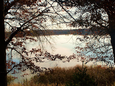
The well above normal temperatures have resulted in late ice over for area lakes. Typical from my views of the past and judging by average high and low temperatures Ice normally begins to form on area lakes around the 14th of November. because I do remember a lot of times when I was younger The ice was thick enough to play on by the week of Thanksgiving. Comparing to Last year by Thanksgiving this Lake above was already iced over and even snow covered by this time! Ice started forming last year about the 15th, This year it is already the 28th and not even a little ice has yet formed on large lakes. but with highs the in the 40s and 50s in the middle of November has kept this lake warm enough to keep ice from forming! Small lakes and ponds Do have a small layer of ice from resent cold nights like Mash Lake and Lake Camila have a bit of ice over them. but today was only there 2nd day in the entire month that it has had ice on it.

Much Colder weather is forecasted to come in by Sunday and even cooler weather late next week, So I do have a feeling that very soon it will be ice covered, The sun angle has been getting very low in the sky and it is hard for the sun to work off ice on small lakes!

Friday, November 27, 2009

Nice weather Saturday cooling off again Sunday.


Regional weather map for Saturday Sunday and Monday.

Saturday, Mild air ahead of some colder air to the northwest will be overhead, Sunday a weak weather system will pass North. Behind this system some cooler air will work back in Dropping temperatures.


Local View.


Saturday we will have Sunshine and mild temperatures, Highs will be in the lower 40s Saturday. Sunday colder air will move in, a weak system will move through as the colder air works in, This will increase clouds and may produce a few flurries if any, in our local area but it would be light with little or no accumulations. Colder air behind this will drop our highs to the middle 30s. Monday will be mainly cloudy or partly sunny, Monday Night things may start to clear out, This might make for some cool temperatures lows will be in the low teens Monday Night, but I would not be surprised if some places fell to the upper teens, Daily forecast below.


Saturday, Nice, Sunny highs in the low 40s. Saturday Night, Partly Cloudy then increasing clouds lows in the upper 20s.


Sunday, Partly Sunny and Cooler, A small chance of some flurries, Highs in the mid 30s. Sunday Night Mostly Cloudy lows in the low 20s.


Monday, Partly Sunny, small chance at flurries early. Highs in the mid 30s. Monday Night, Cool, lows in the low 20s with possible upper teens north.


Looking Ahead forecast. Looks like our Cool weather pattern will continue through next week, looks like high temperatures through the entire week will stay in the upper 30s! I actually see a mainly Dry week ahead at least until Thursday December 3rd. late week, There may be some lights snows, one thing if for sure, The models have been holding onto some even colder air coming for Next weekend, We may have below freezing highs! Sunday and Monday Dec 6Th. the models show a snow system moving in from the west but it's too early to tell if the models will actually hold onto this.


New Map


My new map.

I am adding a new map to my forecasting posts. This is a map that I've taken the time drawing myself to use at my blog, It will show more Regional conditions for a wider view to show how large systems effect the area. I will begin using this map in my next forecasting post which will be issued today.

Thursday, November 26, 2009

Up and Running! & Update about my health.

New Rain Gauge November 26Th.

This is a post showing everyone that I am now using my new Rain Gauge. This is a more professional one then I was using for the past summer so this one will guarantee I wont have overly high readings like I did with my old rain gauge. This gauge will also be used for measuring water content of Snow. I especially want to Thank OSN of Oshkosh,WI Weather for helping me make this possible. The gauge is really working out nicely!

Thanksgiving Center piece with Thanksgiving and a Christmas Cactus on our table!

I hope everyone is having a great Thanksgiving! I kinda wish Yesterdays snowy system would have turned out, I'm kind of in to mood for some snow now, But it just didn't happen. I did see some rain/snow mix but that was it, The system just didn't turn out like I thought it would, We had no snow accumulations anywhere, One thing that sure happened was the cool air! It's a chilly 29.F right now and it's almost 12pm noon! Most people when they went outside were like Wow it's cold! but the interesting thing is, We've cooled down Normal late November highs! It's just been so warm for so long it feels cold to most people!

One of the things that's interesting is, lakes are completely ice less due to the warm weather over the past month. I've always remembered a thing layer of ice at Thanksgiving but I guess it differs from year to year! Now that's it's cooled off I would expect ice to form soon.

Health Update.

I wanted to let my viewers know that, After going back to the Doctor for another visit, I've been diagnosed with Under Active Thyroid, I will have to take Thyroid pills for the rest of my life, This goes along with High blood pressure medication and Asthma Medication. But I'm just happy all of this is getting figured out so I can be healthier, and I also think it's good that I'm getting this figured out now rather then not finding it out.

Tuesday, November 24, 2009

Turning Much colder, a good chance of Snow Thanksgiving looking Cold with some snow- Updated


Updated Forecast for Wednesday, Thanksgiving Day and Friday, with a Thanksgiving Theme.

Chances were made to my forecast, Models are now showing something different then what I saw yesterday read below to find out.

It Will be turning Much Colder for the middle of the week, A Strong Cold and low pressure system will move through the Low Pressure will drag in some Much Colder air, and it looks like this colder air will stick around, The colder air, will turn rain to Snow, This change over will take place later then I first thought, The cold front slowed and "warm" air is sticking around this means it probably wont turn to snow until late now, Highs on Wednesday will still likely be early in the day, Highs will top out in the upper 30s before falling to the mid 30s. Wrap up preip behind the low pressure will spin down from the north, . Light rain will be off an on Wednesday, but the best chance of heaviest snow appears to be late Wednesday and overnight, Winds will also increase late Wednesday, gusting to 25MPH or higher. Thanksgiving Day we will have a good chance of Snow early, Before tapering, Total system Snow accumulations will be held down to lower amounts since the change over is being delayed to .50" to 1" is now what I'm thinking, it will be Windy and Cold, on Thursday, Highs will only make it into the Mid 30s. Friday it will be partly cloudy, but even the sun wont help us warm up much, highs will still only be in to upper 30s, Night lows will be well into the 20s. possible low 20s Friday Night Daily Forecast Below.

Wednesday, Rain early, changing to Snow late in the day, with off and on light rain lasting through the day, Much Cooler, Highs in the upper 30s. Wednesday Night, A good chance of Snow, turning Windy, Winds will gust to 25MPH lows in the upper 20s.

Thanksgiving Day, Cold, Windy, A good chance of snow early Before tapering, Total system Accumulations 0.50 to 1" Otherwise Cloudy, possible some clearing skies late, Highs in the mid 30s. Thursday Night, Cloudy turning Partly Cloudy Late. lows falling into the mid 20s.

Friday, Remaining Cool, Partly Cloudy with highs in the upper 30s. Friday Night, Partly Cloudy, lows in the low to mid 20s.

Looking Ahead Forecast. Longer range forecast are showing a slight warm-up for the first half of weekend but it wont be a huge warm up, It also looks Dry for the weekend first half of the weekend. Sunday & Monday, a small weather system may bring some light snow, it will also drag in cold air once again so Sunday & Monday will likely be cold. look even farther ahead, Tuesdays through Wednesday looks Dry but still cool, I don't really see much in the way of any warm ups any time soon. Late Next Week around Friday and Saturday, The models are picking up on a possible Stronger system, It looks like with cold air already in place it would come as all Snow, It will also bring in another shot of cold air behind it. This System will need to be watched as we go through the next week because if the models hold onto this hitting our area it could be our 1st real snowstorm of the season. It really looks like a more wintry couple weeks ahead especially for temperatures!

Have a Great Thanksgiving!

Monday, November 23, 2009

Record overnight warmth Monday.

Warm Hazy conditions November 23rd.

We have been having mild conditions the past couple days but Especially over the weekend. Highs were in the low 50s on Sunday and Lows overnight Sunday Night and Monday were recorded breaking. lows only fell into the mid 40 upper 40s! Average highs for this time of year are in the upper 30s and averages lows are normally well below freezing. A large area of low pressure over the middle of the country help surge up warmth and moisture and this is what brought us the mild condtions.

A list of some Lows and Highs reached Monday.

The mild condtions we have expereince will come to an end, A big cool down is expected just in time for Thanksgiving, Snow looks to be possible, mainly light accumulations it looks like at this time, highs falling into the mid 30s, More on this later.

Saturday, November 21, 2009

Frosty Foggy and Cool night.

Frost early morning the 21st.


Saturday Morning we had a very still calm air mass overhead, This lead to Fog and dropping temperatures below 32.F This made for some frosty conditions Saturday morning. Some spots had fairly Dense Fog. which lifted later in the morning. lows Saturday morning fell into the upper 20s to low 30s.
This picture shows more of the foggy Detail of our Saturday Morning. Saturday was mild for Mid November Temps rose into the upper 40s! The average High for this time of year is 38-39.F! Sunday morning lows are expected to be much warmer Very mild for this time of year in the upper 30s.

Enjoy the mild temperatures over the next couple days because It will not last too much longer. by Tuesday things will cool off and things will really cool down by Wednesday. A system might pass which could bring us some snow. It will depend on this system if we have a White Thanksgiving of not!

Friday, November 20, 2009

Thanksgiving Cactus blooming!

Yellow Colored Thanksgiving Cactus.

It's 6 full days until Thanksgiving and all Thansgiving Cactus but 2 are blooming! Even my Christmas Cactus is blooming early. It is a very pretty sight expressally when everything is brown outside.

Red Thanksgiving Cactus.

This Red colored Thanksgiving Cactus I bought at last minute last January is in full bloom!


This is a Christmas Cactus my aunt gave me as cuttings from her plant. It has really grown! this is it's frist time blooming.
Heres a close up picutres of the Christmas Cactus bloom.

Pink Christmas Cactus


I still have 3 plants which have not yet opened up there flowers! I will show picutres of those when they open.

Thursday, November 19, 2009

Continue mild and Dry, slight chance of rain by late Sunday then Much cooler?

Weathermap for Friday Saturday and Sunday.

besides some light Drizzle early Thursday this week has been dry and sunny, It is beautiful weather for Mid November! highs have been quite mild in the upper 40s to low 50s. This type of weather will continue for a few more days. A high pressure system will slide across the area which will provide a bit more sunshine before our next system will start to roll in late Sunday. Highs Friday and Saturday will be mild in the upper 40s with low 50s on Saturday. Sunday will be a bit cooler with more cloud cover. Daily forecast below.

Friday, Mild. possibly starting off cloudy with Decreasing clouds, turning partly cloudy highs in the upper 40s. Friday Night partly cloudy lows in the low 30s to upper 20s.

Saturday, Mild, Partly Cloudy and nice, Highs in the upper 40s to low 50s. Saturday Night partly cloudy lows in the mid 30s.

Sunday, Mostly Cloudy, a chance of Drizzle, then a chance of light rain late, Highs in the upper 40s. Sunday Night a chance of light rain lows in the mid 30s.

Looking Ahead Forecast. Early next week on Monday A fairly strong cold front will move through this will bring a chance of rain turning to light snow. The rest of next week looks to remain Much colder then this week has been. The models also throws in a couple of light snow chances our first chance early Tuesday morning, and then another light snow chance Thanksgiving Day, Either way Next week looks to be a lot colder then this week. After Thursday I do see a slight warming trend for Next weekend, before another system comes through early in December right now it looks like it will come as all snow. Remember this can all change but this is what I see right now.

Saturday, November 14, 2009

Another sunny nice stretch coming up Above normal temps.

Weathermap for Sunday Monday and Tuesday.

Well another sunny dry stretch is in the forecast. With mild above normal temperatures. It really doesn't feel above normal but really it is, Highs have been in the upper 40s low 50s and This is about 10 degrees above normal. It is going to cool off a bit but not by much. Highs for the starting of the week will be in the mid to upper 40s. With clear nights lows will fall into the 20s and 30s.

A high pressure system will move in behind our system we had for Friday & Saturday, This will bring Dry sunny & nice weather into the area with above normal temps. Perfect for doing the left over yard work or starting to putting up Christmas displays! Daily forecast below.

Sunday, Sunny and Nice. Highs in the mid 40s. Sunday Night a bit cool, Clear lows in the low to mid 20s.

Monday, Sunny, and Nice, Highs in the upper 40s. Monday Night, A bit cool Clear lows in the mid 20s.

Tuesday, Sunny and continued Nice weather. Highs in the upper 40s. increasing clouds later in the day, Tuesday Night, Warmer Partly Cloudy lows in the upper 20s to low 30s.

Looking Ahead Forecast. The snowy system I was forecasting last week for early this upcoming week has completely disappeared. Now it's looking Dry. Its actually looking Dry all the way through Wednesday. But Thursday the 19th, the models are showing a small weak system pulling in, Right now it just looks like cooler temperatures with rain Maybe changing to flurries before ending. Then were looking at another dry stretch from Friday the 30 through Sunday the 22rd. but Monday the 23rd & Tuesday the 24th, The models are showing a stronger system pull up Pull up from the south. Right now it looks like it will come as all Rain. Rain looks to end just in time for our Thanksgiving holiday. Then Friday the 27 following Thanksgiving We may be looking at a system which may be cool enough to produce snow. It is quite early to tell and Things will definitely change between this time. long term forecasting this time of year is tricky.

Geese Migration, and 1st Thanksgiving Cactus Flower!

Canadian Geese on Lake Magnor.


The Geese are continuing to migrate south! While I was at my aunts house on Lake Magnor, I noticed there were so many Canadian Geese right on the lake! they were enjoying the waters there.
A closer up picture of the Geese on the lake. definitely a lot of them!


Yellow Thanksgiving Cactus.

After Weeks of waiting, The 1st flower on my Thanksgiving Cactus finally opened! This is the 1st flower I've actually grown myself.These Cactus, are my favorite type of house plant. These cactus flowers as the nights get longer and They are really loving our dark long nights that we have here in Wisconsin! I'm still waiting for my other colors to open. but This is the 1st of many flowers, I have 7 Thanksgiving Cactus some large and small most are different colors! I will be posting picutres as they open.

Wednesday, November 11, 2009

Nice November weather. A few lake picutres.


Lake Magnor on a clear calm day.

We have had some great weather over the past few days, Sunshine with highs in the upper 50s. Perfect for early November. I just had to show this picture of Lake Magnor that I took, When I saw how waves less the lake was, I knew I needed a picture because normally there are always at least some waves on the lake but on this day, there was None.
Here is a second picture of Lake Magnor. Lake Magnor is the largest lake in the Clayton area, It has about 3 miles of short line and is fairly deep. It has been quite low for water level this year, Although it is up a some after above average rainfall in October.

Sunday, November 8, 2009

Looking Nice mainly for start of week.

Weathermap for Monday, Tuesday and Wednesday.

Things are looking pretty nice for the start of the week, besides a small chance for rain early Monday. High pressure will effect the weather late Monday through Wednesday, this will pretty sunny warm condtions. Temps will warm into the 50s which isn't bad! night lows will be coolish in the low 30s. Detailed forecast below.

Monday, slight chance for rain early, Then mostly cloudy with gradual clearing later in the day. highs in the low 50s. Monday Night, partly Cloudy, lows in the low 30s.

Tuesday, Mild, Sunny and staying dry, Highs in th low 50s. Tuesday Night, Partly cloudy lows in the low 30s.

Wednesday, A bit cooler but still nice, Sunny highs in the low 50s. Wednesday Night, Partly Cloudy, lows in the low 30s.

looking ahead, looks towards the end of next week we could be looking at another chance for rain. then early the Next week, The models show some colder air pulling in with a couple of snow chances. I will be watching this through the week, but it doesn't look too major at this point.

Saturday, November 7, 2009

Preip Data Changed.

This is a notification that my Precipitation data for my blog has been changed. after looking at the October total rainfall, I noticed it seemed high, but I believed it, but after farther investigation, it proved There was definitely something wrong with the totals. the NWS sites has said most places got between 4-6 inches in Oct. and my total of 10.52" this was far too high. My friend of OSN blog sent me a new gauge and thankfully it came no later. The gauge help me find out the old gauge was reading 2 times too high, the new gauge recorded 0.20" while the old gauge read 0.40"

I was disappointed to find out I might have had to loose nearly 1 years worth of rainfall data, so I wanted to save it. so after a lot of research with a friend of mine, I decided that I would divide all the Rainfall totals in half for the months June through October.

Changes Made.

The changes I made were to Rainfall data, monthly totals for June, July, August and October were changed all the numbers were devided in half. September didn't need changed so it was left alone. Feb,Mar,Apr and May were also left alone, with the months I did change the seasons total was changed, I believe this data is much closer to what it should be. Snowfall data was not changed because I use a different method of measuring which is accurate. Here is a list of monthly totals I got below this includes months I changed.

Feb 2009: Rain 0.08"

Mar 2009: Rain 1.16"

Apr 2009: Rain 2.16"

May 2009: Rain 2.54"

June 2009: Rain 2.91"

July 2009: Rain 1.50"

Aug 2009: Rain 3.84"

Sep 2009: Rain 1.40"

Oct 2009: Rain 4.74" Snow 5.75"

November 2009 -So Far Rain 0.20" Snow 0.00

Seasons Total Rain 21.44" Seasons Total Snow 5.75"

Tuesday, November 3, 2009

A bit of snow, before warming up.

Forecast for Wednesday Thursday and Friday.

Were looking at a chance of snow early Wednesday, from a weak area of low pressure, but I have a feeling most of it will be over before daylight hours, Accumulations will be light, up to a half inch or less. I believe all the preip will come as snow, but there could be a bit of rain mixing in. Highs Wednesday will only be in the low 40s. Thursday will be partly cloudy with temps a bit warmer, highs will warm to the mid 40s. lows in the 30s. Friday is when things really warm up nicely, under sunny skies, Highs will warm into the mid 50s. Detailed forecast below.

Wednesday, a chance of light snow in the morning before ending, total accumulations a half inch or less. cloudy decreasing late in the day, Highs in the low 40s. Wednesday Night, Partly Cloudy, lows in the upper 20s.

Thursday, Partly Cloudy a bit warmer highs in the mid 40s. Thursday Night, partly cloudy lows in the mid 30s.

Friday, Warmer! Nice, Sunny highs in the mid 50s. Friday Night partly cloudy, lows in the low 40s.

Looking ahead our warm and nice day trend will continue into the weekend, Highs may get close to 60 Saturday, then a bit of a cooling trend towards next week. early next week looks like it might be dry and coolish, then the middle to end of next week a system may pull through which could bring is colder weather this system may bring both rain and snow with it. more on this later.

Low Tuesday morning lows!

photo showing whats left of some Oak tree leaves on a cool November day.


The leaves went real quick! seems like they all fell off in the matter of 2 weeks! only late trees have leaves now, It is very bare. Monday night skies cleared and temps dropped like a rock as we are in a dry air mass, most places fell to the low to mid 20s, But a few upper teens were even reported! lows reported below.


Low reported Tuesday Morning.

Places with light cloud cover were held up a bit. but places they were completely clear really fell, some places fell to there coldest leaves so far this season! My station reported a low of 22.F and the coolest spot reported was Baldwin with a low of 18.F! It will get warmer, but not before a bit of snow, My forecast is coming up in a few minutes.

Sunday, November 1, 2009

Very cool & Wet October What I had for totals.

October was Very cool and Wet across northwest Wisconsin, We have lots of rainy weather systems and plenty of snow, We definitely had a well above normal month for preip.

My Rain total for Oct.
The Average October rain is 2.39"

October literally started out above normal for rainfall at my location, the 1st-2nd day of October we already had 2.60" from a heavy system. so even the first weather system of the month put us above normal. Through the month we had many low pressure systems, We ended the month of October with an amazing 9.50" for a monthly rain total, This is the highest rainfall amount I've recorded in a month since I started recording.

My Snow total.
The Average October snow is 0.50"

We also had a well above normal snow amounts in October, this started out with a half inch the 10th then an early wintry system brought 2.75" of snow the 12th. October totaled 5.75" of snow for me

Temperatures & wind
October was a much cooler then normal month, I did not even have 1 high in the 60s during the entire month. My highest temp reading was 59.F October 7th, and my coolest day reading was 36.F both Oct 10th and 11th. my Highest wind gust in the month of Oct was 35MPH from the SW on Oct 30th.

Thanks for reading my totals for the month of October!