Map Image Legend Image

Iowa Weather Network Warnings Map

Iowa Weather Network Warnings Map

Winter Weather Advisory

Sunday, May 31, 2009

image from the SPC

There is a small risk of Severe Weather today for the entire area, Thunderstorms could form in the afternoon along a cold front and then move east. Large Hail and Damaging winds are the main threats. keep an eye to the sky today, just in case storms to develop.

Wednesday, May 27, 2009

Sunny, for now!


Weather map for Thursday, Friday and Saturday.
Our weather will get sunny and Much warmer for the next 3 days There might a shower or thunderstorm Friday, but it is looking slim at this point. Saturday may start of sunny, but I think it will become cloudier during the day later. Detailed forecast below.
Thursday, Sunny and Much warmer then Wednesday, with highs in the mid to upper 70s. Thursday Night, partly cloudy lows around 50.
Friday, Sunny with a slim chance of a shower of thunderstorm. with highs in the mid 70s Friday Night, partly cloudy, lows around 50.
Saturday, Starting off sunny but then more clouds moving in Highs in the 70s. Saturday Night partly cloudy to mostly cloudy, A chance of a shower or thunderstorm late? lows in the 50s.
Looking Ahead I see our weather could get much more active We may even be looking at a good chance of showers and thunderstorms late in the weekend. I am unable to tell if it will be severe at this time, But if severe weather is expected, I will post here. temperatures will be steady in the 70s.

Saturday, May 23, 2009

Maybe some rain? and Happy Memorial Day.

Forecast For Sunday, Memorial Day, and Tuesday.

We are looking at Maybe some rain possible in this forecast, Hopefully we get some, because many people agree it is Dry. We will start of Sunny and Nice for Sunday, and then Monday, it will start off sunny then, I guessed it will become more Cloudy. I believe the rain chances will hold off until Tuesday, At this time it looks like There will be a few scattered showers and thunderstorms. Temperatures look fair, with highs near 70, Even in the mid 70s! lows warming into the upper 40s to low 50s. Detailed forecast below.

Sunday, Sunny and Nice, highs in the mid 70s. Sunday Night, partly cloudy, lows in the upper 40s.

Memorial Day, Starting off sunny, with turning cloudier, Highs in the mid 70s. Monday Night, Cloudy to party cloudy, lows in the 50s.

Tuesday, A chance of Showers and Thunderstorms, Highs near 70s. some sunny spots possible. Tuesday Night, Cloudy, lows near 50.

Looking Ahead, I see slowly warming temperatures and off and on rain and storms chances. I also see off and on sunshine chances. Remember, We are in Severe Weather season, so any week we could be looking a chances for Severe Weather, I will have any information here.

New tree leaves May 23rd,

Boom! is how fast we can describe how fast the trees are leafing out, now it is starting to look like summer! To the left is a purple lilac.

Have a good Memorial Day!

Thursday, May 21, 2009

Western Wisconsin Lilacs.


Lilacs May 20th

The lilacs are in Full bloom here in Western Wisconsin, So I thought I would take this time to talk about them. Lilacs are a very old plant used in Gardens, That's why you often see them planted by older homes and farms, Actually they are commonly planted with Day lilies. The most common color they come in is Light purple. But they come in White, Dark Purple and even pink now. Lilacs here in Western Wisconsin normally come into bloom around the 25Th of May just as the trees are getting leaves. Most people don't know that lilacs actually need our cold longer winters to rest so they can get the energy to flower, That's why you always see lilac bushes loaded with flowers in Wisconsin and the around the upper midwest, when they bloom. Once you get around Southern IL and south, It gets harder to get them into bloom, and they produce less flowers, or none at all. I personally think everyone who lives in Wisconsin and the upper Midwest should have at least one lilac in the yard, just because they have an unforgettable smell which can fill the entire yard. We have 8 blooming bushes scattered around our yard Which spreads the smell no madder which way the wind is blowing They may not last extremely long, but I have to say our longer winters almost makes it worth it for the flowers!


I have never tried this here before but, I would like to that the time now to Mention, I will be selling some of the baby shoots our lilacs have produced. I am selling both Light and Dark purple colors, I have more light purple then dark purple, I am selling them for a fairly good price I believe. I am also selling some other common flowers around our yard. If anyone is interested in some, please send my an email at hostalover360@yahoo.com I will be glad to answer any questions you have about lilacs also.

Photo of Dark Purple Colored lilacs. I will add a photo of my white lilacs tomorrow, They seem to be a tad later then the rest. please check back again tomorrow!


Ok here is a photo of my White double lilac, This lilac was my great grandmas Elsie's, When my Grandma and Grandpa moved into the house, they unknownly, mowed over most of the lilac, because they didn't know it was a lilac, This is what kept it a small enough size to move over to my house, This is the most blooms this lilac has had so far! Thank you for reading this post about lilacs!

Wednesday, May 20, 2009

Wind Damage, Very strong winds and Hot condtions reports

here is a photo of A large cottonwood arm that split a part from this tree by the winds in the Northern part of Clayton.


We had some Very windy and Warm conditions across the area today, Many places reached the 90s for the first time this season and wind gusts were over 40MPH in many areas, a warm front and low pressure to the west is what brought us these hot, sticky and windy conditions. Dust blowing from the Fields south of Clayton

Dust could be seen in the air today, making it look hazy, with a brownish tint, to the air, in some spots it was actually hard to see across the road due to dirt blowing off the plowed fields around Clayton, I was surprised to see that a large arm off of a tree ( in the above picture) was blown down, There were also some other trees down along Highway 63, in this same area, here is a list of reported temperatures and wind gusts Here is a photo taken on the Northern part of the Village, This photo was taken from Mr. Norm Murry's backyard. The wind was especially Strong along the lake shore!

White caps could actually be seen on Lake Camellia Today, In my yard, My wind gauge reported a 46MPH gust in the afternoon, This is the highest wind My wind gauge ever reported so far Since I started recording.
Image from NWS

A Wind Advisory has been issued for Polk, Barron, St Croix and Dunn counties until 7PM this evening.

For more information about the advisory, go to the Local Watches and Warnings from the Twin Cities NWS, and click on your county

Tuesday, May 19, 2009

Huge temperature difference across the area Tuesday!

This map shows the difference in temperatures.

There was a Huge temperature difference across the area today, Due to a very strong warm front that slowly moved north, To about the Polk Barron, Burnett Washburn county lines and remained there throughout the day, There was As much as a 30+ degree temperature difference at one time between the north and south! South of the front Hot Humid conditions were felt 80s and even 90s were reported, while North of the front staid much cooler 60s and a few upper 50s where reported. below of temperatures across the area. Tomorrow, The entire area should be in the warm air mass With 80s and even a few 90s possible.


Here is a list of high temperatures reported across the entire area today.

People driving north on Highway 53 must have been able to feel the temperatures getting cooler today! There was over a 10 degree temperature difference Here is an Example Rice Lake airport sat at 81, While areas just north of Haugen, was 69 That is an amazing temperature difference for such a short distance!

Warm day ahead, then Thunderstorms possible.

Weathermap for Wednesday, Thursday and Friday.

The warmest day of the season is possible on Wednesday, as a strong warm front moves north, and drags up some warmer air. We will have strong gusty winds from the south Wednesday, this will help many places reach the mid 80s, I also believe some places could top out near 90 degrees. Thursday, a cold front will follow behind this warm air, this front may trigger some showers and Thunderstorms in the afternoon, a few storms could be strong, cooler temps will also follow the front, and Friday we will have sunny weather and cooler conditions.

Wednesday, Very Warm and humid, with strong gusts from the south, highs in the 80s, Some places could top out at 90. Wednesday Night, mild lows near 60. partly to mostly cloudy.

Thursday, A chance of showers and Thunderstorms with a cold front, some storms could be strong highs in the upper 60s near 70. Thursday Night, cooler cloudy at first then clearing. lows in the 40s.

Friday, cooler Sunny, highs in the upper 60s. Friday Night, partly cloudy lows in the nearing 50.

Ahead, I see steady temperatures with sunshine into the weekend but a chance of some preip Sunday, and then back to sunny weather with highs near 70, Remember this upcoming weekend is Memorial Day weekend, With Monday being Memorial Day!


Monday, May 18, 2009

Very quick update

Image from SPC

Quick update,

There will be a slight chance of severe storms up north in the Siren/Spooner area, Hail appears to be the main threat, Be on the lookout for severe weather today, I will not be here to update my blog warnings from the NWS. so click on the link to the right that says local watches and warnings, for warning information

Expect highs nearing 80 today in some places, upper 70s should be the rule, with sunny skies.
with a threat for thunderstorms in the afternoon.

Friday, May 15, 2009

Slight Risk Today


Image from the storm prediction center

There is a slight risk of Severe weather for parts of the area today it appears that Thunderstorms will form along a strong cold front today and push east The main threats will be Large Hail and Damaging winds, but there will also be the threat for possibly a few tornado's. The areas that will see the highest chance of severe storms today is in the Western parts of the area for places like Somerset, Osceola, up to Grantsburg east to by Siren and Amery. People across the area, but especially in the west today should be on the lookout for severe storms today.

Thursday, May 14, 2009

Rain/storms possible, Then Freezeing temps possible!

Weathermap for Friday, Saturday and Sunday.

First I will talk about the rain and storms expected for tomorrow. A strong cold front will begin to push east during the afternoon, a few showers and storms should form off this front, A few storms could be on the strong side, with Hail and maybe Strong winds being the main threats Before the front goes though, temps will warm into the middle 60s, with strong south winds, Then later in the day, This Cold front will push though, then winds will turn northwesterly, and become strong. Expect much cooler temps behind this front.

Saturday, temps will be slow to warm, and when they do we will only warm to the middle 50s, possibly upper 50s. and it will be sunny, as a Cold high pressure starts to settle in. This cold high pressure will set up the stages for a unseasonably cold Night Saturday Night. freezing temperatures are possible. and frost is likely in some areas, It appears that lows will fall into the low 30s, but some places could fall below 32.F and possibly in places around Minong, upper 20s may be a possibility. The growing season has started here in Northwest and West Central Wisconsin, so be sure to take in all tender plants Saturday. I want mention Again freezing temps may be a good bet, Especially in low spots, and areas that tend to be cooler.

The good news is Sunday will be Warmer, and sunny with highs in the low 60s, and Sunday Night people will not have to worry about frost. it will be clear Sunday Night with lows in the 40s, upper 30s still possible in areas of the extreme northeast.

Friday, a chance Showers and Thunderstorms a few could be strong, Highs in the mid 60s, before the cold front moves though, strong south winds turning west, northwest and becoming stronger. Friday Night, mostly cloudy at first then becoming clear, lows in the low 40s.

Saturday, Cool, and gusty, highs only in the mid 50s. Saturday Night, cold, widespread frost in some areas, with lows in the low 30s, upper 20s possible up north near Minong.

Sunday Much warmer then Saturday, sunny, with highs in the low 60s. Sunday Night, Warmer, no frost or freezing temps expected, lows in the low 40s.

Looking ahead WARMER weather is what I see looking father into the forecast. by Monday most places will be reaching near 70, then by Wednesday we could be looking at middle 70s for highs! chances for Thunderstorms starts to move in late next week, so everyone just hold on a little longer, Warmer weather is coming!


Monday, May 11, 2009

A bit more active weather, Showers/Thunderstorms over the next few days.

Weather map for Tuesday and Wednesday.

We will have some more active weather the next two days, Due to a Low presser system Warm and Cold front to the west. This system will first pull in some warmer are on strong south winds, This system will also bring a pretty good chance of showers and Thunderstorms starting Later Tuesday, with a better chance of rain Tuesday Night, into Wednesday. Scattered showers and Thunderstorms will be a good chance for Wednesday I will add the small chance for a possible Strong storm if things set up right, but We should be mainly looking at just rain and thunderstorms. Then Wednesday a cold front will move though with it a chance of Thunderstorms, Detailed forecast below.

Tuesday, Partly sunny to start off then cloudy. Rain chances coming in during the day, Highs near 70, Strong breezy winds. Tuesday Night. strong winds calming a bit, but still breezy with a good chance for showers or Thunderstorms. lows near 50.

Wednesday, a good chance of scattered Showers and thunderstorms, highs in the upper 60s. strong south winds. Wednesday Night, showers ending, Cooler and cloudy, lows in the 40s.

Looking Ahead after Wednesday we will see come cooler and direr air for Thursday, But warming right back up Friday, with more active weather with a good chance of showers and Thunderstorms. I can not tell if any of this will be Severe at this time.


Here is a picture of some flowers on a tree near my house, I'm not sure what kinda of tree this is, but I know they are Native to Wisconsin, and it blooms every year.

Tulip project!

Tulips and Daffodils May 11Th


Well Here is a picture of my Tulips, I was waiting for a sunny day because tulips only fully open on sunny days. These tulips were a part of a project I started back in December, I put tulips along with daffodils in the fridge, To plant in the spring. This was the second year for Daffodils, but my first year trying this on Tulips, This project was a success! I got blooms out of both the Tulips and Daffodils!
Tulips May 11Th

The funny thing about these tulips is, I got two packages of tulips which were all different colors, including colors pink, purple, and Orange, and some that were supposed to be purple with stripes of white, along with Red and Yellow colors, But the only color tulips that bloomed are the most common colors for Tulips, Red and Yellow, I planted two separate clumps on different sides of the garden and it ended out being the same on each side, only Red and Yellow colors are blooming! Even though these two colors only bloomed, I think I did a pretty good job on these, and they Smell great!

Friday, May 8, 2009

Cool weekend coming up, Patchy frost possible.


Saturday, we will have some lingering showers in the south, left over from a low pressure to the south, Behind this system, a Cool high pressure will move into the area, This will cause cooler, and much drier air to move in. Skies will likely stay cloudy most of the day Saturday, but I believe there may be some clearing late Saturday, Saturday Night, we will have a cool night, If clouds totally clear out, Patchy frost will be possible Saturday Night, in the cool areas, but Especially in the north. Sunday we will have sunny skies, with highs near 60, but Sunday Night we will have the coolest night of the weekend. lows as cool as the mid 30s are possible, Patchy frost will be possible. Take in any tender plants for the nights, this weekend. Detailed forecast below.

Saturday, Lingering showers moving off to the east, Some clearing possible late in the day, Highs in the mid 50s. Saturday Night, Cool, if clouds totally clear patchy frost will be possible with lows in the mid to upper 30s, but if clouds remain then upper 30s is what will rule.

Sunday, Sunny, a bit cool, highs near 60. Sunday Night, Clear, Cool Patchy Frost Possible. lows in the mid to upper 30s.

Once again Take any tender plants in this weekend.

Extended view, We will warm up come Monday, and you will not have to worry about any frost Monday Night. Highs will return to the low to mid 60s, and lows will warm back into the 40s, By midweek some chances for showers and thunderstorms moves in. More on this later.

Wednesday, May 6, 2009

A little beaten up but still nice.

Daffodils May 6Th
Here is a photo of a Daffodil clump my aunt gave me earlier this spring, To see if I can finally get daffodils to survive the winter in my garden, Since these come up every year in her garden. When my aunt and I dug these up I thought they would be a single daffodil White petals and a yellow center, but They turned out to be a Double daffodils with white petels and orange centers! I actually think these white ones did the best in yesterdays hail storm with hail to the size of quarters, I think they did the best out of all the daffodils I have. Even with the hail damage to them I think they still look nice. I have no idea how the 2 yellow ones got in there!

Severe weather possible today

Image from the SPC

I am not taking any chances today, There is a chance for Severe Thunderstorms across the entire area this afternoon, Large Hail, and strong winds
dangerous lightning and heavy rain will be the main threats. Today's weather will be caused by a low pressure system. Here is a link to the latest severe weather outlook. SPC- outlooks

Tuesday, May 5, 2009

Severe Thunderstorms across the area including at my location.


Hail covering our yard May 5Th

Severe Thunderstorms broke out across the area today, Which caught me totally off guard. First I'll talk about the storm that effected me, one isolated Storm became severe started producing nickel sized hail in Northern St Croix County in Star Prairie. The NWS in the Twin Cities issued a warning for quarter sized hail just before it hit Star Prairie. I was watching it on radar as it continued to drift Northeast. for a time the NWS radar was detecting some weak rotation in the storm just before it hit Clayton. I thought I could see clouds lowing to southwest of my location. but nothing dangerous Then after awhile Hail started to fall. it first was nickel sized, but then started to reach to the size of quarters. During this time it was almost all hail which was falling with not much rain.
Hailstones that I picked up to show the size Note the hail did melt some.

Hail kept coming in waves it seemed like. after awhile the ground became totally white with hail Which could even be seen by my live camera. This storm also bought lots of cloud to cloud lightning, it seemed like the thunder never slowed down. The temperature really dropped during this storm, we started off at 62 before the storm and right after we cooled to 52.F! Now I will talk about other areas effected by this storm. Shortly after producing Quarter sized hail at my house it continue east and produced nicked sized hail which also covered the ground in areas north of Prairie Farm, After that the storm weakened, There are no more reports from that storm at this time. Now I will talk about the storm which effected north Polk County and Southern Burnett county. This storm formed right in northern Polk county The storm became strong near Milltown but did not start producing severe hail until it reached Lewis. Where quarter sized hail was reported penny sized hail was reported southwest of Siren from the same storm, after that it continue northeast but weakened.

The Damage

Daffodils all shredded from the Hail May 5Th.
a closer look at the shredded daffodils

This storm brought the most hail I had ever seen, I really have to say I never seen so much hail from one storm. The nickel to 1 inch hail was devastating on the spring blooming flowers in my garden. You can see the petals shredded off laying on the ground below the plants. You could also smell the strong sent of pine after the hail ended because of the hail damaging some of the needels.


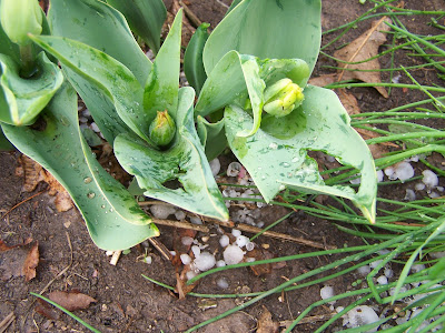
The unopened tulips really took a hard hit from the hail! One of the tulips I saw was even completely cut off the plant! I should still see some flowers when they open.

Here is a photo of the fog after the storm pasted. Right after the storm we broke out into sunshine which would explain the fog forming from the cold hail in the ground! the white spots are hail piles!
One last photo of This Huge pile nearly 1 foot deep! hail pile really amazed me when I found it! The hail and heavy rain brought the hail off the roof and out the gutter this is what caused this to pile up here it really looks like snow!

Here is one video of the hail that fell at my house. You can clearly see the hail bounceing off the yard, I added a note in the video to show where one of the bigger hailstones landed. This was after the heaviest hail core. for another good video during a heavier hail core please go Here

Reports

St Croix County Star Prairie 0.88 inch hail

Polk County Clayton 1.00 inch hail " hail covering the ground lots of quarter sized hailstones"

Barron County 3 N Prairie Farm 0.88 inch hail " Sheriff Deputy reported pea to nickel sized hail covering the ground"

Polk County Lewis 1.00 inch hail "about quarter sized hail but most were smaller"

Burnett County 4 SW Siren 0.75 inch hail

Monday, May 4, 2009

Clayton Schools Closed

I thought I would post this information to be helpful, since this is my very own town. I'm Sure it is Just for precaution But, Clayton Schools will be closed for the next 3 days ( Monday Tuesday and Wednesday) due to a probable case of H1N1 virus.. People across the area should take extra care of themselves to avoid getting sickened by the flu. for more information Please go to the Clayton School District

More photos everything in full bloom it seems!


Apricot Tree flowers May 4th

Wisconsin really does start to get pretty this time of year. Many things are going into full bloom here, I have also seen early trees really starting to green up and Late ones are starting the early stages of leaf out. No that is not snow you are seeing in the above photo it's a Apricot tree in full bloom! They bloom even before the leaves come out, making it look like snow to me, this the most I've ever seen this tree bloom, which is making the bees wild for these the past 2 days. The Grass is really starting to grow, and some people have already mowed there yard for the first time this season.


I thought some people were wondering what a weeping willow "flowers" might look like, well here they are, They are not very showy, but there really put an unforgettable sweet sent in the air. The bees have also been all over this tree too. Here is One more photo of the daffodils in Full bloom, I thought I would post another one since more have opened up then in my last photo. Tulips are getting close to blooming.
some people probably would like to see the greening trees we have around here. Since I have talked about it. Most of the green your seeing is from Poplar trees. but in a few weeks I bet everything will be shaded.


Saturday, May 2, 2009

Nice next couple of days coming up, Then rain chances

Weathermap for Sunday, Monday and Tuesday

Weather for the next two days looks to be Nice with warming temperatures and Sunshine. but some isolated clouds with sprinkles will be possible Sunday. but should mainly be sunny, With a high pressure nearby, Warmer air will start to flow in from the southwest, and we will really be feeling the warmer air by Monday but we have to get though a cool night Sunday Night first. With the Dry air, We will fall into the 30s once again, but I believe it will be above 32.F then it will be Warmer Monday Night, Tuesday We will be looking at Rain and thunderstorm chances starting to move in. Which we need because it is beginning to get dry again. Temps will be stable in the mid to upper 60s Tuesday. With warmer night lows. Detailed Forecast Below.

Sunday, Sunny, Warmer then Saturday, Highs in the low 60s, Isolated sprinkles will be possible. Sunday Night, Cool, and clear With Dry air and clear skies expect temps to fall into the Mid 30s with light frost possible. take sensitive plants indoors just in case.

Monday Warmer and Nice with Sunny skies, and Highs in the upper 60s, with low 70s a good bet I believe. Monday Night Much warmer then Sunday Night, lows staying in the mid 40s.

Tuesday, a chance for Showers or Thunderstorms later in the day, with highs in the mid 60s Tuesday Night, a better chance for showers or Thunderstorms. with lows in the mid to upper 40s.

Looking Ahead Temperature wise, temps will become more stable and warmer then they currently have been. I see 60s for highs and 40s for lows. It definitely looks like we will fall into a slightly more active time, with at least a few chance for light Rain though Saturday chance for We might be finally looking at even warmer temps for the middle of next week, 70s look possible for highs, but I am not totally sure, More about this later.

Friday, May 1, 2009

Green-up Update

Daffodils in Full Bloom May 1st 2009

We are really greening up nicely with the rain the past week, I am already noticing some early trees with a green hue from a distance, so if you look out on the landscape you can see some patches of light green on early tree to leaf out, Late trees are just starting to break buds and flower buds. Grass has really been noticeable greener, hay fields and yards are totally green there is not much brown grass left anymore. I have seen Spring Daffodils are in full bloom across town, as well as in my garden, I have seen a few Tulips that Are just starting to bloom, but My tulips are not blooming yet. I also noticed Greenhouses are opening up and selling flowers. Watch out for cool temperatures the next 3 nights but especially tonight, some places might get close to freezing which may cause some light frost. I think most areas will stay above 32.F but if you were temped to buy flowers and have put them out already I would bring them in at nights for this weekend Scroll down to see more pictures below!

The grass in our front yard

Pretty soon I will be mowing this! Lilacs are all leafed out here while trees in the back round have none! Lilacs normally bloom around May 25Th


I thought this photo looked neat You can see the weeping willow with a greenish-yellow hue with partly cloudy skies behind. The yellow hue is from all the yellow catkins starting to bloom, which have a sweet smell to them.