Map Image Legend Image

Iowa Weather Network Warnings Map

Iowa Weather Network Warnings Map

Winter Weather Advisory

Thursday, September 27, 2012

Fall Color Report # 4 Moderate Color Reported Cannon Falls and Austin 50-75%. Low color everywhere else 25-50%.

Photobucket
Fall Color Report # 4 September 27th 2012.

Fall colors are really getting a jump start across Southeastern Minnesota! Warm daytime temperatures are causing trees to rapidly change colors.  Cannon Falls and Austin are reporting Moderate color. Here earlier and mid changing trees are producing high color in beautiful shades of orange, maroon and yellow. Low color is being produced everywhere else, but these areas are picking up quickly and will likely be reporting moderate color in just a few short days! Fall colors are this rate are actually occurring slightly earlier then normal, we could be peaking in color in some areas by the end of the 1st week of October. Typical peak time for Southeastern Minnesota is the 2-3rd week of October.

 Photobucket
Fall colors in Ash and Maple along 4th St SW Sept 27th

Fall colors are really picking up big time here in Rochester. Streets with Ash and Maples, both Sugar and Reds are beautiful! Ashes have turned golden yellow and I've seen Maples in colors of yellow, orange and red. Burning bushes are also turn stunning colors of blaze red. I would rate Rochester's color around 45% and we are quickly approaching the moderate color range.

Photobucket

Fall color in Sugar Maples near 6th St SW Sept 27th

Sugar Maples are always one of the best fall color producers!

Photobucket 
Front yard ash turned Yellow. Sept 27th

The tree in our front yard literally went from green to yellow in a one week time span. I could just see that it was beginning to turn and now it has completely turned a beautiful golden yellow.

Wednesday, September 26, 2012

Very dry weather pattern in place next several days. Sunny every day, temperatures in the 70s with calm winds.

Photobucket
Regional weather view.

An area of blocking high pressure will bring a long string of sunny calm days to all of the Upper Midwest for the next week. This is unfortunately bad news because it is worsening drought conditions across this region which really needs widespread good rainfall. Look for every day to repete its self with highs in the 70s region wide.

Photobucket


PhotobucketLocal and Metro views.

It is very easy to be a forecaster this week becasue the weather will be quite boring for the area. Every day will repeat it's self one after another. The only slight difference will be temperatures, which will be very mild and pleasant for this time of year. We can expect highs starting in the lower 70s on Thursday, warming to the mid to upper 70s for Friday and through the weekend. Lows will generally be in the lower to middle 40s, warming to the 50s each day. We can expect this type of pattern through at least Tuesday of next week as an area of high pressure remains situated over the area. This pattern will lead to expanding drought. I don't see any chance of rain until the end of next week.


Thursday, Sunny nice and mild. Highs in the upper 60s to lower 70s. Thursday Night, Clear skies, lows in the lower to middle 40s.

Friday, Sunny, nice, Warm!  Highs in the mid to upper 70s. Light winds. Friday Night, Clear skies, lows in the mid to upper 40s 

Saturday, Sunny skies, nice, warm! Highs in the low to mid 70s. Saturday Night, Clear skies, lows in the mid to upper 40s.

Sunday, Sunny skies, nice and warm! Highs in the low to mid 70s. Sunday Night, Clear skies, lows in the mid to upper 40s.

Monday, Sunny, Warm! Highs in the mid to upper 70s. Monday Night, Clear skies, lows in the upper 40s to low 50s.

Tuesday, Sunny and warm! Highs in the upper 70s. Tuesday Night, Clear skies, lows in the upper 40s to lower 50s.   

Looking Ahead

Wednesday and Thursday the 3/4th looks like another warm sunny day for the area. Highs may be in or around the 80s. Friday the 5th our next chance at seeing rain, and things look a little interesting with this system but only to a point because models have been very un reliable at predicting rain this year. The model shows widespread rain across all of Minnesota Friday the 5th into Saturday the 6th. A cold front swings through Saturday bringing significantly colder air into Minnesota. There might be some snow in Northern Minnesota with that system as it exits. Dries out, and remains on the cooler side for Monday the 8th, and remains cool, dry and sunny through the 11th of October.


Monday, September 24, 2012

Fall color report #3 Rochester, Red Wing and Winona joining rest of area in low color. Southeastern areas around Preston still seeing little in the way of color.

Photobucket

Fall color report 3 September 24th 2012

Fall color is beginning to get a bit of a boast across our area. Color is really starting to increase as the days continue to get much shorter and the sun angle lowers. Now, all areas accept for the southeast is reporting low color. Trees like Ashes, Maples, Sumac, area really showing plenty of color currently. Yellow, Orange and Red can all be seen. Shrubs like Dogwood and Burning bushes also also showing signs of maroon and fiery red color. For a map of colors across the rest of Minnesota see the Minnesota DNR website
Photobucket
Sugar Maple September 24th 2012

Around Rochester I've mostly noticed Sugar Maple and Ash trees turning the most. The ash tree in the front yard is really starting to turn yellow at a fast rate. I've seen a few neighborhood burning bushes turning red as well, but when I look across the landscape, the primary color is green.

Photobucket
Asters  in full bloom September 24th 2012

One thing for sure is fall color in blooming flowers are peaking right now. This is a relatively new plant for me, I got this plant originally from Wisconsin last year. I really this perennial because of the very showy flowers fairly late in the season. These are among the last flowers to bloom in the Upper Midwest. They are a little earlier then normal this year due to a warm spring, typically you would see them blooming in mid October. They have really proved to be a great addition to the garden, and because there late season flowers there are hardy to frosts and cold!

Sunday, September 23, 2012

Freeze/Freeze this morning, lows ranged from the lower 30s to as cold as the upper 20s. Growing season has ended for most of the area.

Photobucket
Widespread frost in the back yard on the morning of September 23rd.

It was a cold morning throughout the area today as the 1st very cool frosty night of the season occurred behind a system that brought the 1st snowflakes to Northern Minnesota. The cool conditions send temperatures falling into the upper 20s to lower 30s across most of the area, ending the growing season for most places. What is interesting though, corn across the countryside was completely un effected by the freeze because it has already matured because of a very early planting season. In my backyard we had a hard frost, the backyard was completely covered with frost, tender plants I did not cover to protect it had fair amount of damage, about half of my pumpkin leaves were hit, still it was not a completely killing frost in because were kind of protected by the city. This frost/freeze came a little earlier then normal for what is expected in Southern Minnesota. Early October is more typical for the first hard frost. Compared to last year temperatures of this magnitude it occurred earlier on the 15th of September.


Lows reported Sunday Morning.

Here is a list of low temperatures seen. The coolest reading area wide was 28.F at Dodge Center, Mazepaa, and Dodge Center. It staid a bit warmer toward Preston where the low was 32.F. In the Rochester Metro, inner city areas had lows around 33.F, while outlying areas had lows ranging from 28 to 32.F.

Saturday, September 22, 2012

Very Chilly and breezy Weekend ahead. Cold front will bring very little rainfall but sigificantly cooler air. Widespread hard frosts looking likely Saturday Night lows falling to the lower 30s. Then warm up next week. Updated X1

Photobucket

Regional weather view.

The 1st very fall like weather system will be making at least a few headlines across the Upper Midwest for this weekend. A small but strong system will push a cold front through the region on Friday, bringing rain, and even a few early pre winter snowflakes to Northern Minnesota, where a bit of accumulation is possible. Behind this front cold air will pool southward bringing widespread frosts and freezes to much of Wisconsin, Minnesota and Northern Iowa. Warmer air will eventually move in earlier next week bringing more seasonable temperatures but continued dry weather to the region. Worsening and expanding drought conditions will continue for Minnesota and Wisconsin, with continuing droughts everywhere else.
Photobucket

Regional and Rochester metro views
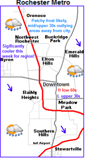
                                                                                                                                                                                        Very chilly weekend. Highs in the 50s with widespread frosts Saturday Night. 

PhotobucketThis weekend is going to have a very fall like feel to it. We will have chilly conditions, clouds, breezy northwest winds and even widespread frosts.  The system mentioned above will effect the area in the following ways. Friday, will be partly cloudy with highs in the lower 60s. Showers will move in on the storms cold front. These showers will be light in nature and offer little help in the way of relief from the drought. Saturday will be kinda cold with strong northwest breezes to 30MPH. High temperatures on Saturday will struggle to reach the lower 50s. Skies will start off cloudy and then clear as the day goes on. This will set the stage for a 
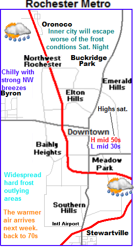
cold night Saturday night and Sunday morning. Lows will drop off quickly after sunset. Lows will fall to the lower 30s for most areas. With a few the low valley areas possible seeing upper 20 degree readings, with these temperatures widespread hard frosts is likely . This could very will be the end of the growing season for much of the local area. Heat island effect will protect help inner city areas of Rochester escape the worst of hardest the frost/freezes, but frost is still likely in this area with lows in the middle 30s. Sunday will still be on the chilly side with highs in the upper 50s to lower 60s, and lows in the upper 30s to lower 40s.

Indian Summer? Warmer air arrives next week with dry conditions developing.

Next week for the areas the pattern turns quiet again, which is bad news for drought conditions, but it looks much warmer as warm air moves back in from the west. Next week actually looks fairl, y nice, with most days around 70s, with lows in the 40s, a few days will be on the breezy side. 

 Note: Hard frosts likely this weekend. You will want to cover tender plants! Tend plants will not survive the expected temperatures without cover. More statements can be seen above.

Saturday, Cloudy breezy and cool. Showers possible in the morning. Winds gusting to 30MPH. Highs in the middle 50s. Saturday Night, Cold! Clearing skies with lows in the lower to middle 30s inner city Rochester. Widespread hard frosts likely.

Sunday,  Chilly, Sunny skies highs in the upper 50s to lower 60s. Sunday Night, Clear skies lows in the upper 30s to lower 40s.

Monday, Sunny and Much warmer. Highs in the lower 70s. Breezy with south winds to 35MPH. Monday Night, Clear skies lows in the upper 40s.

Tuesday, Sunny, Nice! Light winds with highs in the lower to middle 70s. Tuesday Night, Clear skies, lows in the upper 40s to lower 50s.

Wednesday, Sunny skies, Nice! Highs in the lower to middle 70s. Wednesday Night, Clear skies, lows in the upper 40s to lower 50s.

Looking Ahead

Our next shot of much needed rain could arrive Thursday the 27th, when a warm front could spread some showers across Minnesota. It doesn't look like much at this time but its worth looking at. Looks dry and pleasant for the weekend into the 1st part of October. The 3rd of October a developing cold front spreads widespread showers across the region. The models shows this as being a fairly beneficial system. We'll see if it holds. I really don't see any major cool downs into the 1st week of October.


Thursday, September 20, 2012

Fall color repotrt # 2 Cannon Falls, Dodge Center, Austin reporting Low color 25% All other areas little to no color.

Photobucket
Fall color report September 19th 2012

The latest fall color report is showing color picking up in western areas of the area. Cannon Falls, Austin and Dodge Center are all reporting at least 25% color now. With little to no color in central and eastern area. Color is higher in areas where drought is more severe. Trees showing colors right now include earlier changing trees like Ash, Sugar Maple, Sumac and Burning bush.

Photobucket
 Fall color appearing in a Green Ash tree September 19th 2012.

I've just starting to notice fall color appearing around the city. I've seen a few Ash trees and Maples turning colors. Still color is still fairly hard to find right now, as typical peak time is still a few weeks away. I suspect with the warm up next week color will really begin to show up!


Tuesday, September 18, 2012

Chilly morning this morning! Lows fell into the middle 30s some areas with 1st frost of the season.

Photobucket
Lows this morning, September 18th 2012

It was a chilly morning across the area thanks to the arrival of a chilly, fall-like airmass from the north that arrived early Monday on blustery northwest winds The 1st frost was observed with these temperatures in many spots. Skies were slow to clear yesterday but once they did towards evening things became mostly clear, this helped influence the temperatures last night. Lows across the area were generally in the mid to upper 30s with the exception some extremes, like Winona and Zumbrota, which both had a low of 34.F, the landscaped influenced this some as cooler air sinks into the lower valleys that those two cities are located. In these locations frost was probably more widespread and possibly more damaging. On the other side of the spectrum, areas of deep within the city of Rochester had lows in the 40s because of a heating effect from the abundance of buildings and heated surfaces like parking lows and roads.

Interesting statement

The low at my station in West Downtown Rochester was 40.F Interestingly enough though, I did see a tinging of very light frost in the yard this morning even though the low was 40.F. The frost was so light that it was difficult to see and did not harm any vegitation. It was possible for the frost to occur because air cools as much as 10.F on clear nights as you approach the grounds surface, and it warms as you go up in feet to a certain extent. My weather station is up 6 feet above the ground because that is national standards for height. Even this being the case it is still this is the warmest temperature at 6 feet that I've seen frost occur on the ground.

Sunday, September 16, 2012

Sigificantly colder air making its way southward for the work week, Frost threat tomarrow night with the threat for showers with the passing of the front temperatures will be only in the 50s to near 60 Mon/Tues, then much warmer Wednesday.

Photobucket
Regional Weather view.

A very sharp change in the pattern is expect for the start of the new work week. A strong cold front will plow through the region bringing with it the threat for much need showers across Minnesota and Wisconsin. After the passing of the front, the 1st real cool air of the season will make its way southward from Canada, bringing with it frost and freeze potential for areas of the north. The weather will be sunny, chilly and dry for Tuesday, with increasing warmth Wednesday and Thursday with sunshine and dry weather expected across much of the region.
Photobucket
Photobucket


Local and Metro view.

Significantly cooler and wetter for Monday with Frost potential Monday Night. Continued cool for Tuesday

A very sharp cold front will be felt across the area starting tomorrow as the coolest air of the season pours in. Monday will be cloudy and very cooler with showers and temperatures in the 50s, being 20 degrees cooler then highs on Sunday. The rain will be widespread in the morning but will mainly be of the light variety, amounts will be minor and range from around 0.10 to 0.30" of an inch. The main story with this front will be the much cooler temperatures. After highs in the 50s on Monday skies will clear out in the evening hours allowing for temperatures to really drop tomorrow night. Patchy frost is likely with lows topping out in the middle to upper 30s in typical cool areas and low spots. Warm spots, and inner city parts of Rochester should be safe from any frost as lows fall into the upper 30s to lower 40s. Tuesday will be sunny and dry with highs in the upper 50s to lower 60s. Tuesday night will be another one with lows in the low 40s with possibly a few upper 30s in a few spots.

Gardeners Note: Annuals and tender crops can be harmed in the expected temperatures, do not forget to cover or bring indoors!

Warmer Wednesday and Thursday.

Wednesday warm air surging ahead of our next system will be much warmer then Tuesday. It will be sunny with highs in the lower to mid 70s on Wednesday with breezy south winds gusting to 35MPH. Thursday will also be sunny and dry with highs in the mid 60s and lows in the low to mid 40s.

Monday, Chilly! Rainshowers in the morning then decreasing clouds. Highs in the upper 50s to low 60s. Monday Night, Very Chilly! Clear skies with lows in the mid to upper 30s. Patchy frost likely, outlying areas away from inner city Rochester, lows in the mid to upper 30s, to upper 30s to lower 40s, inner city Rochester.

Tuesday, Chilly and sunny, with light winds. Highs in the upper 50s to lower 60s. Tuesday Night, Chilly, Clear skies with lows in the upper 30s to lower 40s.

Wednesday, Warmer sunny and breezy. Highs in the lower to mid 70s. Southwest winds gusting to 35MPH Wednesday Night, Clear skies lows in the mid to upper 40s.

Thursday, Sunny skies, light winds. Highs in the mid to upper 60s. Thursday Night, Clear skies lows in the lower to mid 40s.

Looking Ahead. 

Friday a small weather system will develop in Minnesota and bring the chance for showers and a few thunderstorms to our area, then the systems cold front passes through bringing windy northwest winds and sharply cooler conditions for Saturday.  What is interesting is some of the models suggest a snow flurries threat in far northern Minnesota with this system. For our area it would likely be a coo day with a frost threat. Sunday, through Tuesday of the upcoming week looks fair and dry. A warmer trend makes its way in for Wednesday, before a front brings a chance of showers on Thursday. It dries out with about average highs for the weekend of the 30th. Then the models want to hint on a bigger weather system for Monday October 1st bringing with it widespread heavy rains for much of Iowa, Southern Minnesota and Wisconsin. We will have to see how long this holds. It would be quite good news for drought stricken areas if this continued to show over the next few weeks!

Thursday, September 13, 2012

Fall Color Report #1 Low color all areas. Plenty of color in fall prennials which are in full bloom.

Photobucket
Fall Color Report #1 September 13th 2012

It is hard for some to believe it is already Mid September! Fall is quickly approaching, the nights are getting longer and cooler, and the days shorter. Soon trees will be changing beautiful colors and loosing leaves, meaning that it is time to start covering fall color! This week there is little to no color across the entire area. It is a bit too early for us to being seeing much in the way of color, but still one may find some color among earlier changing bushes, and trees such as Ash and Sumac, and Dwarf Burning Bushes. I suspect more color will begin to show as cooler crisp days move in and most important to leaf change, as nights get longer in the coming weeks. Normal peak time for Southern Minnesota is the 2nd to 3rd week of October.
Photobucket

Front yard view September 13th 2011.

Looking at the front yard view there is really no color to be seen. It continues to have the looks of summer as lush green Hostas, Hydrangeas and Mums fill the frontyard landscape.


Photobucket

Mammoth Mum September 12th 2012

There is one place Fall Colors are really starting to show though, and thats in the garden. Fall perennials are blooming at least 3 weeks to a month early this year. Mums and Asters are approaching or are in full bloom.

Photobucket
Large Aster September 13th 2012

This is a large leafed perennial aster, which has not even reached full bloom yet!


Wednesday, September 12, 2012

It was very hot and windy on Wednesday. highs reported in the mid 90s at some stations.

Photobucket
Landscape September 11th 2012

Summer continued to make it's presence known that it is still here today as highs raised into lower to middle 90s. These temps were blowing in on strong south winds gusting to nearly 40MPH. Today's high were about 20 degrees above the normal highs which typically this time of year are in the mid 70s. Average low temperatures are in the mid 50s this time of year. The cause of the warmed was hot air pushing ahead of a cold front which will plow through the region today, bringing much cooler weather and scattered showers through out the day and through this week. Long range models show a much cooler tread for most of the rest of this month so it is quite possible this may be our last 90 degree highs, which some people may be happy to hear after an extreamlly hot summer.

Photobucket

Highs/Wind gusts September 11th 2012

High across the area ranged from the lower 90s in the south to the middle 90s in the north. Part of the reason for the flop in temperatures is because there was less wind causing less mixing in the north. No records were actually broken today in our local area but many near ties were seen. Father north Minneapolis/St Paul Airport had a high of 95.F 1 degree shy of  tieing a record of 96.

Sunday, September 9, 2012

Warm and windy to start off the week. Winds could gust to 40MPH, Showery and cool condtions developing by Wednesday, then drier and warm for next weekend.

Photobucket
                                      Regional Weather View

A hot windy could of days is ahead for the region ahead of the areas next weather maker. A strong cold front will sweep in on Wednesday ans Thursday spreading showers across the region. The shower threat will continue into Thursday for parts of Minnesota, Wisconsin and Iowa. Thursday will be a chilly day across much of the region, only to warm back up some for the end of the week. The end of the week looks drier and warmer with just below seasonable temps


Photobucket
PhotobucketLocal and Metro View.

Very warm and windy next 2 days.

Highlights in weather the next week is a warm and windy Monday and Tuesday is expected. Daytime highs will be in the mid 80s to low 90s and lows in the middle 50s. Dewpoints will not be high so heat will really not cause any issues. Winds however may, strong south winds will be gusting 35-40MPH at times Monday and Tuesday.

Showers developing Wednesday Night/Thursday

A strong cold front will push across the state, reaching our area late Wednesday. This system will bring showers and thunderstorms to our area eventually developing after dark Wednesday into Thursday for our area. Severe weather is unlikely. Rainfall amounts will range from a few tenths of an inch to maybe over a half inch in localized areas. High temperatures Wednesday before clouds will be in the 80s, with lows in the 50s. Thursday clouds will linger from storms and high temperatures will not warm out of the 60s, lows will be in the upper 40s to low 50s.

Warmer and drier for weeks end.

Drier weather moves back into the picture for the end of this week as high pressure again takes over. Friday, Saturday and Sunday will all be similar in weather with sunshine, highs in the low to mid 70s, and lows in the upper 40s to mid 50s. It will be a beautiful weekend to get things done!

Monday, Sunny, Very Warm and Windy! Winds gusting to 35MPH. Highs in the mid 80s Monday Night, Clear skies lows in the middle 50s.

Tuesday, Sunny and Hot! Windy, Winds gusting to 40MPH. Highs  in the upper 80s to lower 90s. Tuesday Night, Clear skies lows in the mid 60s

Wednesday, Sunny skies, highs in the low to mid 80s. Increasing clouds. Wednesday Night, Showers and thunderstorms developing. Lows in the upper 50s.

Thursday, Cool. Showers and thunderstorms in the morning. Then skies remaining cloudy. Highs in the mid 60s.  Thursday Night, Clearing skies, lows in the upper 40s to lower 50s.

Friday/Weekend Questionable-Sunny skies light winds. High temperatures in the lwo to mid 70s, lows in the upper 40s to lower 50s.

Looking Ahead

The weekend is a little questionable and this time. Some are saying it will be sunny while another run may be hinting and much rainier and cooler weekend. Then the long range charts are really hinting a much cooler times ahead for the end of this month. Early next week as that system moves away, a very chilly airmass races southward on Monday the 17th. Frost.freeze chances look like a sure bet across much of the state, especially north of our area. It warms up and dries out for the end of that week, Thursday to Friday. Then Saturday the 22nd a low pressure system racing out of Iowa spreads widespread showers and rain to much of the Upper Midwest. Heavy amounts may be a possibility. Another system follows that one right behind it and brings another shot of rain for Monday. It looks cool and sunny behind this feature.

Friday, September 7, 2012

Drought condtions expanding across the area. Exceptional drought in parts of Mower and Fillmore counties

Photobucket

Minnesota State Drought Monitor September 6th 2012

Drought and dry conditions are continuing to become a significant issue across the local area. The latest drought monitor has put the entire area into a status, and southern areas in Far southern Mower and Fillmore counties in severe to exceptional drought. Moderate drought extends into eastern Winona County. This dry snap started more then a year ago in late July of 2011. It is worsened by the fact that we had a very dry, warm winter and at very hot dry summer. Areas of the south are anywhere from 8 to 9 inches below from where they should be at this point in the season. As of January 1st areas like Preston was 5.83" below normal, Austin is 8.52" below normal and Rochester International Airport is 5.06" below normal. If you go back even further from when this drought started August 1st 2011 to September 4th 2012 you can see that Preston is 13.72" below normal, Austin is 17.08" below normal and Rochester Airport is 13.10" below normal. The dry conditions have been helped some by recent storms but with dry weather expected for the next week it will continue to be an issue. The main effects of the dry season are shorter corn crops, significantly low rivers, damage to lawns and landscapes and early leaf drop. The far worst conditions in the area are seen along the Iowa/Minnesota border which is in exceptional drought conditions. Hopefully we can get into a wetter pattern this fall to help ease dry conditions across the area.

Effects of Fall Color Season 2012

With the very dry warm winter leading into a dry hot summer we are expected to unfortunately have a very poor fall color season this year, similar to last year. I have noticed some trees trees are already responding to stress and a dropping their leaves early without any color at all. Trees that don't lose their leaves will likely have dull colors because of the lack of rainfall. A warm fall would speed up this process and lead to faster leaf drop.

Wednesday, September 5, 2012

2 Rounds of damaging thunderstorms impact the area 1st produced very large hail in Winona and Fillmore counties, 2nd round very sigificant squall line with severe winds in Dodge, Mower and Olmstead Counties. Area wide damage and power outages. Wind gusts as high as 74MPH reported in Rochester.

Thunderheads from thunderstorms causing severe hail in Fillmore county September 4th 2012

The area was highly impacted by severe thunderstorms on Tuesday rolling over into the early Wednesday  morning hours. The storms caused everything from extreamlly large hail over 2 inches in diameter to very high winds causing widespread damage. This report will break down the 2 events into 2 separate stories which will be in order of time they occurred.

Early Afternoon Very Large Hail Winona and Fillmore Counties

The 1st bout of severe weather erupted from a front pushed through the area. The storms in the afternoon mostly produced significant hail. Thunderstorms exploded over Western Winona, and Northwestern Fillmore County. The storms pushed east and south where they quickly started dropping significant hail in the St Charles area. One report listed  hail over the sized of golf balls southwest of Utica This particular cell continued to push east which eventually produced large damaging hail all along the I-90 corridor. Two other cells developed, one west of Winona which produced golf ball sized hail in the community of Stockton and quarter sized hail in the city of Winona. The second sell developed over Preston, where it 1st dropped pea sized hail there covering the ground in Preston. The thunderstorm grew which eventually produced tennis ball sized hail north of the community of Canton. This report was by far the large hail reported in the 6 county area.  The storm continued to push southeast eventually developing high winds and continued hail Northeast of Mable until it moved out of the area into Iowa.  The hail caused damage to crops, trees and landscapes as well as to property like siding and windows on homes and cars.

Storm Reports

  5 miles N Canton 2.50" Tennis Ball sized hail

6 miles SSW Utica 2.00" Hen Egg sized hail

Stockton 1.75" Golf ball sized hail

3 miles W Utica 1.75, Golf ball sized hail

Goodview 1.00" Quarter sized hail 

Winona 1.00" quarter sized hail

4 miles NNE Mable 60MPH wind gust, 2.00" hail Hen Egg sized hail, car dented.

Large squall line forcing its way into the city of Rochester September 5th 2012

As the 1st round a storms dissipated a stationary front remained over the are, setting up stage for the 2nd round of thunderstorms. The second round was a powerful squall line which produced widespread high winds from 55 to 70MPH across the area, but especially across Mower, Dodge and Olmsted counties. They initially developed and started in South Dakota in the afternoon hours of the 4th and pushed all the way across Southern Minnesota through the evening hours, arriving in Southeast Minnesota around and after midnight. 

Photobucket
 Radar shot of the squall line pushing through Mower and Dodge Counties September 5th 2012

One radar the storms seemed to intensify as they pushed into Dodge County and Mower Counties. The first reports of winds were ranged from 53 to 59MPH at Austin and Dodge Center. One of the biggest problems with these storms were area wide power outages. The 1st reports of power outages were in Austin and Kasson along with tree limbs down. The storm then pushed into the Rochester Metropolitan area where it send very high winds ranging from 61MPH at the International Airport to as high as 74MPH at St Marys Hospital in West Downtown and my neighborhood. Widespread tree damage and city wide power outages were reported. Power outages were reported in Byron, Northwest Rochester, West Downtown, Elton Hills, Emerald Hills and Meadow Park neighborhoods. Some places remained without power for 10 hours lasting into most of the next day. Most of the damage from the winds were large limbs and trees down blocking roads. Large tree limbs and trees falling on homes and cars damaged property, I've seen and heard everything from cars being significant damaged to roofs having damage from falling limbs. Some reports in the city included, Several large trees blocking several roads on Rochester SW side 6th AVE SW And Apache Mall area, Large Branches down in West Downtown with power flashes seen. Trees down in in Emerald Hills, Trees Down in Northwest Rochester. The storm eventually left the Rochester are and continued to produce strong winds. 50 to 56MPH Winds were reported at Preston, Harmony, Mable and Plainview before the storm finally weakened. Spotty damage was reported in these areas. 
Photobucket
 Power flash with power out in my West Downtown Neighborhood. September 5th 2012

The best way I can describe this storm is hurricane-like because thats what it felt like to me. This storm was different then other wind producing storms, besides being the far worst that I've experienced here, the wind was embedded with the rain giving it that hurricane look in my eyes. The direction of the wind because of the shape of the storm was out of the WSW and gusts them selves were not sustained but long bursts of winds that seems to come from several different directions, which is supposed the be relevant of a mesocyclone. The winds were so powerful I could hear it blowing hard through the trees which made a roar sound as the gusts blew through them, The amount of debire and leaves flying through the air was also very noticeable. and it lasted a very long time. As I was filming the storm go through I observed power flashes from transformers blowing in the distance, which I did not fully realized until after a few flashes becuase the flashed had no sound and looked like lighting. Eventually the power went completely out and staid out in my neighborhood for 3.50 hours, which I later learned that a large tree falling 2 blocks from here onto the power line was the cause. The closet wind gust reporting station to me is St Marys Hospital which recording a wind gust of 74MPH. The hospital can be seen as the lights in the photo above, I will admit that the winds were likely a bit higher on the St Marys wind anemometer because it is 8 stories above the ground. Winds closer ground level were probably a bit lower.

Strong wind gusts September 5th 2012


 I have 2 videos of the storm as it blew through my neighborhood. This first one is of the strongest wind gusts that could be seen in view when the power was still on. The video it's self was taken on a protected east side of the house while the wind direction was WSW. Because of a wind tunneling effect of an apartment building to the north of our house it was funneling the wind between the garage and the house causing the wind here in this video to be actually blowing out of the north. Higher wind gusts noted in the video are when extreme bursts of wind were pushing between the buildings.  


 Strong wind gusts with power flashes and power outages.

 This second video is of the very high winds wind taking out the power my neighborhood. Several power flashes can be seen as roaring wind gusts blow through. The power goes on and off twice before remaining off. The lights on the hospital were not effected becuase they have emergency generators which keep the power on.
Photobucket
 Leaf litter from high winds SW Rochester,MN

This is the view looking up my street the next morning. A significant amount of leaves blew of trees which was heightened because of trees loosing some leaves from drought stress. 
Photobucket

Tree snapped SW Rochester

Located in my neighborhood. 


Photobucket
  Branch down in our yard.

The worst damage in my neighborhood was a large branch that fell into a car smashing a window out at the corner of the block from me. This photo taken at our yard was taken more because of the location of the branch. It flew quite a distance from the tree in the backround. The wind direction would be from the corner of the yellow house strait towards the camera, but the marigolds to the upper right are blown down from the north wind of the tunneling effect of the buildings.
Photobucket
 Large section of a tree down at St Marys Park.

This was the most significant tree damage that I took photos off. I worst damage I came across was a very large mature basswood tree which fell and caused damage to a retaining wall and a car.

Storm Reports

West Downtown Rochester 74MPH wind gust, large branches down, power flashes with power out.

Rochester Airport 61MPH

Southwest Rochester Trees blocking roads in the Apache Mall Area and 6th ST SW

Emerald Hills Trees Down, power out.

Northwest Rochester Trees Down, power out.

Meadow Park, Large branches down, power outages. 

Byron, Large branches down, power out. 

Dodge Center 59MPH

Preston 56MPH  

7 miles N Mable 55MPH

Austin 53MPH, Branches down, power outages.  

Plainview 50MPH


Tuesday, September 4, 2012

Slight risk for severe thunderstorms tonight.

Image from SPC

A Slight Risk for severe thunderstorms has been issued today for Southeastern Minnestoa, Northeast Nebraska, Northern and Central Iowa, Western and Northern Wisconsin. This includes all of the local area. A cold front will push across the region today into a warm humid airmass. Thunderstorms will spark on this front in Minnesota, Nebraska and Northwest Iowa early, and move eastwards as nightfall approaches. Large hail, damaging winds and tornadoes are the main threats with these storms. Locally heavy rainfall is also a possibility. Be storm aware today, especially this evening and early tonight. 

Monday, September 3, 2012

1 more Hot and Humid Day with Needed rain threat tomarrow along with the chance for severe thunderstorms tomarrow. Pleasently cooler for the middle part of the week.

Regional weather view.

There is some weather to speak of in the Upper Midwest this week. A weather system moving across the region will spark showers and thunderstorms to parts of Minnesota, Wisconsin and Northern Iowa. Some of these storms will have the chance to become severe. This system will bring much needed rain to parts of the region. The front its self will put an end to a very summer like airmass that has been over the region for a week now. Behind this system cooler more seasonable temperatures will be found. It also looks generally drier for the region after Thursday.


  Local and metro views.

Rain threat Tuesday, Severe Storm Threat.

Locally tomorrow is out best chance for much needed rain over the next few days. It will also be out hottest day with highs topping out near 90, give or take a few degrees. The cause of the potential rain will be a weather system moving into the area from the west. It will cut into a warm humid airmass currently located over Southern Minnesota. Thunderstroms will develop on this front some of which could be strong to severe in the local area.  Heat rain, hail, highs winds and the outside chance for a tornado will be the highest risks. The threat will of course hinder on certain factors, right now it does not appear to be a very high risk, however it is there. Heavy Rainfall is also a possibility with localized amounts nearing or topping an inch. These amounts will be localized though and it is very possible we will end out with a situation where some wont see any rain at all. Best chance of storms will be after 5pm to after dark for the local area.

Cooler and drier for Midweek.

After the passage of the cold front much cooler and drier conditions will move in. It will almost feel comfortably cool. Skies should clear out nicely especially Wednesday afternoon, staying sunny through Thursday. Highs will be lowered to the mid to upper 70s, and lows in the upper 40s to lower 50s and thats not even where it will bottom out. Friday will be cooler with rather cloudy skies developing and maybe even a few sprinkles. Highs will only be in the lower 70s and its possible some places may not get out of the 60s. Lows will be in there upper 40s to low 50s.

Tuesday, Hot and Humid Sunny with highs in the lower 90s. Thunderstorms developing. Tuesday Night, Showers and thunderstorms. Some could be strong to severe. Lows in the  lower 60s

Wednesday,  Chance of storms early otherwise pleasantly cooler and less humid. Wednesday Night, Cool, Clear skies. Lows in the upper 40s to lower 50s.

Thursday, Sunny skies with seasonable temperatures. Highs in the upper 70s to low 80s. Thursday Night, Increasing clouds, lows in the mid 50s.

Friday, Partly sunny skies with a few sprinkles.  Highs in the upper 60s to lower 70s. Friday Night, Clear skies lows in the upper 40s to lower 50s.

Saturday, Sunny skies with highs in the lower 70s. Saturday Night, Clear skies lows in the lower to mid 50s.

Sunday, Sunny and warmer with light winds. Highs in the mid to upper 70s. Sunday Night Clear skies lows in the mid 50s.

Looking Ahead

Looking ahead into the next work week it really doesn't enlighten us to more rain chances. It shows us staying dry, with seasonably temperatures. The model only shows intermediate chances of light rain towards Friday the 14th. Towards the end of the model run it shows things getting a little more interesting. Sunday September 16th a very strong cold front pushes through the region, ahead of it a warm humid airmass moves over the upper midwest. Thunderstorms with have rain threats develop over Minnesota, Wisconsin and Iowa lasting into Monday the 17th. Behind it cooler drier conditions for midweek of the 19th. The runs have been a little all over the place with this system but it appears like it could be one of the first stronger systems of the late summer season.