 Regional View.
This forecast was issued to help notify people of the severe weather chances tomorrow and Friday, this counts as the update to Thursday forecast from my last issue.
A low pressure system, with warm and cold fronts will pass through the area the next few days, bringing with it a good chance for much needed rainfall. Warm, somewhat humid conditions will set the stage for Severe thunderstorms which are possible across most of Minnesota, Wisconsin, Iowa and Illinois Thursday into Friday, as the system cold front pushed through. Cooler, showery and rainy conditions will follow on the back side of the low.
 Local View.
For the local area, Most of Thursday should be dry, but it will be windy with strong SE winds near 40MPH at times, with rain chances increasing the most after noon Thursday, then rain becomes pretty likely, Some storms could be strong Thursday afternoon, and it cannot be completely ruled out that there may be a few severe storms close to the local 6 county area Thursday or Friday. Friday has a the best chance of rainfall, with thunderstorms fairly likely, Again some storms could be strong to even possible severe. This is the first real chance at Severe Thunderstorms the area has been in so far this season. We should see some pretty nice rainfall totals with this system, as it will be slow to move out bring us soak rains through the weekend. Temperatures will be fairly warm close to the 70s Thursday and Friday, it may even feel a bit more muggy. then temperatures cool off Saturday to the 60s with a chance at showers,
Thursday, Warm and Windy winds 35 to 40MPH at times, Partly Sunny then a chance of Thunderstorms in the afternoon, some storms may be strong, if not severe, highs in the low 70s. Thursday Night, a chance of showers and Thunderstorms, otherwise mostly cloudy with lows in the low 50s
Friday, Warm, Showers and Thunderstorms possible throughout the day, some could be strong or even severe, heavy rainfall possible. Highs in the low 70s. Friday Night, a chances of showers and thunderstorms otherwise mostly cloudy, with lows in the upper 40s.
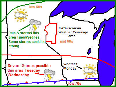
Saturday, Windy, and cooler, with a chance of showers. Highs in the low 60s. Saturday Night, Mostly Cloudy with lows in the low 40s.
Looking Ahead.
at lest a snall chances if Showers may last into parts of our Sunday with this low pressures system that will be pulling in. It does looking cooler behind this system. Things dry out some for Monday, and temperatures appear to warm up to fair values. Then we got even warmer with rain chances increasing slightly again for Wednesday May 5th. Then a warm-up with dry weather the 6th-7th, then the forecast models show a strong cool front push through the 8th with a chance at rainfall, too early to tell if this will be severe or not, but it's something to watch. then I see chilly temperatures around the 9th, but the cool air doesn't look to stick around long, warm air pushes back in after this date, more on this later.


 Image from SPC updated outlook for Friday.
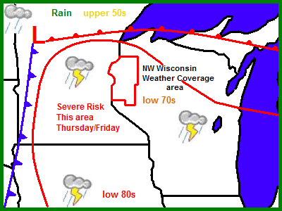

 Local View.


 4 Tulips along side many yellow Daffodils April 22
 A batch of a dozen Tulips April 22
 Local View.
 Local View.
 Spring Daffodils and Hyacinths in full bloom April 16


 Local View.

 Local View.


 Reported temperatures Friday Morning.
 Local View.


 large Purple Crocus April 1st 2010.
 Young Weeping Willow leaves April 1st.
  Lilac Sprouts April 1st.