Map Image Legend Image

Iowa Weather Network Warnings Map

Iowa Weather Network Warnings Map

Winter Weather Advisory

Monday, April 30, 2012

Warm and humid weather for the rest of the week with bouts of thunderstorms. Multiple severe weather outbreaks possible Tues and Wed with potential for torrienntal rainfall!

Regional Weather Map

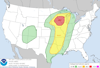
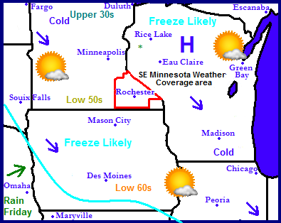
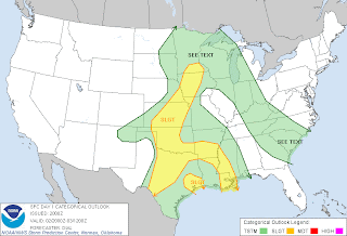
The weather story is currently focused on the Midwest as a severe weather outbreak is likely, with the potential for heavy rainfall over a large area. Passing low pressure systems along a meandering front will produced bouts of showers and thunderstorms, especially in Minnesota and Wisconsin over the next few days. Every day there could be a threat of severe storms with this with the heightened risk of damaging wind, hail and tornado's especially in Minnesota and Wisconsin.

Local and Metro views.

I will get right to the topic at hand. A very wet, stormy warm and humid week is ahead. The focus for these storms will be a frontal system which will get near the area and stall out. This will be the focus and produce waves of thunderstorms with more then one severe weather threat. Tuesday severe weather threat will be mainly an evening/after dark threat. Before the storms each day it will be a warm and humid. It will actually feel quite sticky as dewpoints rise into the 60s and stay there much of the week, highs each day will be in the 70s to 80 with lows in the 60s. Tuesday Thunderstorms will develop first in Western Minnesota and move east, they will likely be here after 6pm. What is left of those storms could be severe and heavy and have heavy rain. Wednesday could be have the highest severe weather threat. Thunderstorms will develop along the stalled out front in the afternoon it is will likely some of these storms become severe, although with this there is the potential for have torrential rainfall, Temp wise highs in the 80s and lows in the mid 60s which will future fuel storms. Thursday and Friday will both be warm and humid with highs in the upper 70s and lows in the 60s, with a threat for thunderstorms both days. It is too early to determine the severe weather threats, but it is certainly a possibility.

Tuesday Night and Wednesday evening severe weather threat!

Tuesdays Threat: thunderstorms will form along a cold front first in western Minnesota and move east across Minnesota, reaching the local area around or after dark, what is left of the storms there will impact the local area, Damaging winds and large hail will be the main threats in our area. Wednesday threat: A frontal system will be near if not directly over the area which is prime for thunderstorm development,  thunderstorms will develop along this front in the afternoon and evening and some will likely be severe. Very Damaging winds, very large hail and tornado's along with torrential rain over 2+ inches will all be a possibility.  People in the area should take this 2 day severe weather threat seriously and stay closely tuned to weather information over the course of the week. There could be multiple severe weather threats over the course of the next few days!

Tuesday, Partly Sunny breezy, warm and humid! Highs in the upper 70s. South winds gusting to 35MPH at times. Thunderstorms approaching towards evening, some could be severe and have heavy rain. Tuesday Night, Thunderstorms, some could be severe and have heavy rain. Otherwise cloudy with lows in the low 60s.

Wednesday, Partly sunny warm and very humid with highs in the low 80s. Heat index approaching mid 80s. Thunderstorms developing in the afternoon, some will likely be severe and have torrential downpours. Wednesday Night, Thunderstorms, Some will likely be severe and have torrential downpours. Then Cloudy with lows in the mid 60s.

Thursday, Partly Cloudy warm and humid. A chance of thunderstorms in the afternoon. Sunny with highs in the upper 70s to low 80s. Tuesday Night, Partly Cloudy, a chance of thunderstorms. Lows in the mid 60s.

Friday, Partly Cloudy, Warm and humid. Highs in the upper 70s to low 80s. A chance of thunderstorms in the afternoon. Friday Night, Partly cloudy with a chance of thunderstorms. Lows in the mid 60s.

No looking ahead forecast as multiple threats of severe weather are possible over the course of this week and attention needs to be focused on that!
Sunday, April 29, 2012

Spring Growth Update #6 Leaves of Summer!

Downtown Rochester skyline April 29th 2012

This is a canopy view of Rochester as of the current date. The Downtown skyline can be seen in the back round with a crane to the left which is currently working on the future Richard O. Jacobson Building. The weather has been back and forth between warm from near 80 on Tuesday to cold, in the upper 40s with sleet on Saturday. Despite this the growing season has continued to progress at a fairly good rate. Most trees have completely grown in leaves now at least 95% of trees have full grown leaves, with only late trees such as Ash, Honey Locust and Walnuts still having small leaves.

Backyard view April 29th 2012

The title of the post should be called Summer Growth Update because the yard the has a more summer look then Spring! The young Red Maple now has full grown leaves and Lilacs have almost completed it's bloom cycle. I've even went ahead and have begun planting summer tender flowering annuals in pots. In the gardens, Hostas and Peonies are slowing stealing the show, or soon will be. It's quite odd to be talking about Peonies blooming already. In Wisconsin, I'm accustom to them blooming on the 1st day of Summer, here in southern Minnesota they bloom in late May, but there very early this year.

Front yard view April 29th 2012

Most of the tulips that were blooming are done, but A few groups of late Tulips are sill pretty. All my summer perennials are now up and thriving! The Ash tree is taking its time leafing in, but the Silver Maple next door has fully completely leafed out and is doing what there famous for, dropping seeds!

Thursday, April 26, 2012

Increasingly Cold for Saturday and Yes, wet snow flakes could mix in with Saturdays rain! Then quick warm up with it looking increasingly warmer for Sunday/Monday, but still looks wet.

Regional weather view.

It has been going a bit backwards in our seasons now, The main story for the weekend is a storm system passing through the Upper Midwest. The center of low pressure will pass through Iowa, spreading widespread rains across South/North Dakota, Minnesota Wisconsin and Iowa. There is even the threat that  a few wet snowflakes could mix in in Minnesota and Wisconsin, but there will be little if any accumulation. It looks increasingly warmer for everyone already on Sunday as the system departs and warmer air moves in from the west, but this will also increase shower chances for Monday.


Local and Metro views.

Yes, if you heard snow you were right! It looks increasingly cold and wet for Southeastern Minnesota this weekend and especially Saturday! A low pressure centered well to the south in Iowa will spread rain into our are late Friday after a cloudy day with highs in the mid 40s and lows in the 40s, Saturday will be cold, cloudy wet and raining steady most of the day. As the rain falls even though it will start off in the 40s temperatures will cool down through the 40s and into the 30s even in the middle of the afternoon. As this happens some of the rain may mix with wet snowflakes at times. This snow will not cause problems and will not accumulation becuase of very warm ground temperatures that we have. If any did accumulate it will be light and melt fast. The good news is up to 0.50" of much needed precip is possible by Saturdays end. Lows Saturday will not fall below freezing. Clouds will help keep temps in the mid 30s. There should not be any threat of hard frosts during this cool down. Sunday looks drier and quite a bit warmer. Under partly sunny skies highs will warm to the mid 50s and lows will be in the 40s. Monday as a warm front approaches it looks much warmer, even with cloudy skies and a threat for increasing showers and possibly some thunder. Highs will be in the upper 50s with lows in the mid 40s

Friday, Mostly Cloudy, Winds, east winds gusting to 35MPH at times. Highs in the mid 50s. Friday Night, Cloudy with a chance for light rain late. Lows in the upper 30s.

Saturday, Cold and wet. Cloudy with a good chance of rain, mixing with wet snowflakes in the afternoon. No accumulation. Highs in the mid 40s. Saturday Night, Rain possibly mixing with wet snowflakes. No accumulation. Lows in the mid 30s.

Sunday, Warmer, Partly sunny with highs in the mid 50s. Sunday Night, A chance of showers late, otherwise cloudy with lows in the low 40s.

Monday, Partly Sunny with a chance for showers, and possibly thunder. Highs in the upper 50s. Monday Night, Cloudy with a chance for showers. Lows in the upper 40s.

Looking Ahead- Significant warm up for next week, mid 70s by Wednesday

The cold snap does not last long and all becuase were already looking at much warmer times ahead. This also means increased chances for rain. The models hint on a chance for showers and Thunderstorms Tuesday night and Wednesday with highs near 70.  Its too early to tell if these will be severe, but some decent rain is possible in isolated areas. The threat for thunderstorms remains in the forecast through Thursday as a front remains close by in Iowa. Then things really warm up and become humid for the weekend of the 5th, It looks dry and warm for Saturday, but Sunday has a threat for showers and thunderstorms. Then Monday a warm front passes through and it becomes very warm and humid, and wet as well, every other day appears to have the threat for showers and thunderstorms, some could bring heavy rain on Tuesday the 8th. A cold front sweeps through on the 12h bringing another chance of a round of showers and thunderstorms. All in all to sum up the long range forecast, wet have the chance to become warm and very wet!

Sunday, April 22, 2012

Changeable temperatures, Sunny with warm up to the mid 70s by Tuesday, then chance of rain Wednesday with a cooldown to the 50s by Thursday

Regional Weather View.

A quiet weather patten to start the week will be in places across the region bringing moderately warmer temperatures and sunny skies. By Tuesday highs will be approaching 80 in Iowa.  Wednesday a frontal system will pass through bringing a quick shot of rain. Behind it its back to cooler air and sunny dry conditions for Wednesday

Local and Metro views.

Locally we can expect a very nice start to the week! Both Monday and Tuesday should feature mostly sunny skies with moderating temperatures. Highs Monday will be in the mid 60s, with lows in the low 40s. Tuesday will be the warmest day. Skies will be mostly sunny with highs in the low to mid 70s, with lows in the 50s! This warmth will be very short lived. Wednesday a frontal system passing through will bring in a quick shot of showers and thunderstorms. None of this rain will be too heavy or cause many problems  there will probably not be too much rainfall with this either and it will not be an all day type rain, most should be light in nature. Then Thursday it will dry back out and become much cooler, highs will only be in the mid 50s with lows in the mid to upper 30s. Some light frosts will be possible, especially outside of Rochester.


Monday, Pleasant and nice! Sunny skies light winds, highs in the mid 60s. Monday Night, clear skies, lows in the low 40s.

Tuesday, Sunny and warm! Light winds with highs in the low to mid 70s. Tuesday Night, clear skies lows in the low 50s.

Wednesday, Partly cloudy with a chance of showers and thunderstorms. Highs in the mid 60s.  Wednesday Night, clearing skies, lows in the upper 30s.

Thursday, Much cooler, Sunny skies light winds with highs in the mid to upper 50s. Thursday Night, a bit chilly, clear skies with lows in the low to mid 30s. Light frost possible.

Looking Ahead

Looking towards next Friday, things warm back up a bit for Friday, then for the weekend a system looks to bring a shot at rainfall, especially Sunday, some could be heavy, It remains mostly cloudy for Monday with fair temperatures before a larger storm system spreads in heavy rains form Iowa to start the 1st Tuesday of May, some of this rain looks quite heavy. We get a break Thursday through Friday, with partly cloudy skies with fair temperatures. Then things look to start getting increasingly warm, humid, and stormy as we approach the week of Tuesday May 8th. We could be seeing more chances of severe weather during this time. More on this later.

Friday, April 20, 2012

Benefical Rains yesterday! 1+ inch amounts in some areas, with some nearing 2"!

Photo of the steady rain that occurred April 20th 2012

A storms system with a stationary front in Iowa caused a huge area of rain to develop across Southern Minnesota yesterday. This spread steady beneficial rains across the entire local area! The rain started around 11AM in many place, an increasingly got heavier as the day went on. It made for a cold wet day in the 40s. By the afternoon everyone was in light to moderate steady rains. The heaviest rain was across Northwestern and Southeastern parts of the area. The rain improved to be very beneficial, especially to areas in severe drought, most south of Zumbrota got over half an inch, with less then that towards Cannon Falls. Hopefully we can keep this wet pattern and put a dent in the deficit that we have.

Rainfall Amounts from Thursday

Dodge Center 1.79"
Lanesbro 1.49"
Austin 1.40
Winona 1.20"
Eastern Rochester 1.05"
Rochester Airport 1.05"
Lansing  1.03"
West Downtown Rochester (my sta.) 0.98"
Red Wing 0.94"
Kellong 0.76"
Aultura 0.65
Lake City 0.58"
Cannon Falls 0.29"


Wednesday, April 18, 2012

Spring Growth Update # 5 Lilacs in full bloom in Early/Mid April!

Lilacs in full bloom April 18th 2012

There you have it Lilacs in Mid April! The Lilacs actually started bloom on the 9th of the month before that big cold snap arrived. I was stunned to see that most plants were fine and were not harmed despite us getting a freeze 3 nights in a row. The lilac pictured above was dug up potted last spring from bushes in my hometown yard. It was planted the ground in summer of last year and this year it is blooming, which is quite interesting becuase they normally take a few years to develop roots before they will flower. Lilacs normally bloom a couple weeks before Memorial day in May here in southern Minnesota.

 Backyard view April 17th 2012

Here is the backyard as of this week. The red maple to the left slightly I planted in August when I started college has leafed out nicely and is now in full leaf! I am excited to watch this small tree grow into a great shade tree. In the yard flowers that normally bloom in Early Summer are blooming now, Perennial Geraniums have started, peony have buds and Hostas are fully leafed out. Spring bulbs like Tulips and Daffodils are on the fast decline or have completed faded. I have already begun to prep pots for summer blooming annuals!

3rd story view.

This is a canopy view of the neighborhood, It looks much like summer! Most trees now have full sized leaves on them, there are only a few species which have little or no leaves yet, some are Ash, Walnut and Hackberry.


Crabapple trees near St Marys Park April 15th

Crabapples are still the main show in many spots of the city, there are some very beautiful streets in Rochester becuase they are completely lined with crab-apples. It really looks and smell great!

Crab apple by St Marys Park April 18th

Here is another crab apple filled completely with flowers. I believe this is a Spring Snow variety.

This Week is Severe Weather Awareness Week in Minnesota! Tomorrow: Tornado awareness and Tornado Drill.

This week is Severe Weather Awareness week in Minnesota! People should take this time to learn more about tornadoes and the warning system that defends most communities against it. Tomorrow is focused on tornado awareness! It is a fact that severe weather hits Southern Minnesota annually, and it is likely that at least somewhere in Goodhue, Dodge, Winona, Wabasha, Mower, Olmstead and Fillmore will see a severe storm this year. In the state of Minnesota, tornadoes are seen several times a year at least somewhere. So now great time to learn and plan in case it should happen.

2 Tornado Drills Tomorrow!

Tomorrow tornado sirens will ring across the state and across the area as 2 tornado drills are scheduled (weather depending) the 1st afternoon one is at 1:45PM and the second evening one is at 6:55PM. Siren Information:  Many people do not not that tornado sirens are for people who are outside only and they are not meant to be heard indoors, but there are systems designed to be heard indoors. SAME Weather radios send warning messages directly from the NWS are are deigned to be heard indoors.

More information about severe weather awareness week can be found at NWS La Cross

Tuesday, April 17, 2012

Changible temps from warm to cool with Much needed rainfall arriving over the course of the next few days. Wednesday looks while with Tstorms while Thursdays looks chilly and quite wet with snow flurrly potienal. Then much drier and nice for weekend.

Regional weather view.

Quite an active and changeable pattern set up for the region to end this week. A series of weather systems passing through Minnesota and Wisconsin will bring mutiple rain threats over the next few days. Most of the rain will be in Northern Iowa, Minnesota and Wisconsin. North of the passing systems it may even be cool enough to snow a bit, While southern Iowa should be mostly dry dispite some rain with the cold front it will otherwise be, sunny and warm.


Local and Metro views.

We can expect very changeable weather for the next few days here in Southern Minnesota. It will literally go from warm to cold back to warm again! The good news is we have multiple chances for rain as a series of fronts and systems pass through. We have the potential to get over a half inch come Friday. Wednesday have a chance of showers and thunderstorms in the morning as a warm front passes, then in the afternoon it will be sunny and warm with highs in the upper 60s and lows in the 40s. The systems cold front will pass through Wednesday night bringing in cooler weather, but the next system is right on its heels bringing clouds and more rain chances to the area. Thursday looks to be the chillest and most gloomy day.  It will be cloudy with off an on showers with highs in the upper 40s and lows in the mid 30s. As temps cool overnight Thursday there could be some snow flurries. Friday will be chilly, there will be a chance of drizzle or flurries in the morning, then skies will clear and highs will reach the low 50s. Friday night will have a threat of some frost as skies will clear and will low will be falling to the low 30s Saturday and Sunday look much more pleasant for the area. We should have plenty of sunshine both days, Saturday will be in the mid 50s with lows in the upper 30s, While Sunday will be much warmer with highs near 60s and lows in the 40s.

Wednesday, Morning showers or thunderstorms, then partly cloudy with highs in the upper 60s. Wednesday Night, Cloudy with a chance of showers. Lows in the low 40s.

Thursday, Cloudy and chilly. Off and on rain showers with highs in the upper 40s. Thursday Night, Chilly with showers, possibly mixing with snow flurries late. Lows in the mid 30s.

Friday, A chance of flurries or showers in the morning, then clearing, highs in the low 50s. Friday Night, Chilly Clear skies with frost possible. Lows in the low to mid 30s.

Saturday, Sunny skies. Highs in the mid 50s. Saturday Night, Cloudy with lows in the upper 30s.

Sunday, Warmer, Sunny skies highs in the 60s. Sunday Night, Clear skies lows in the low 40s.

Looking Ahead

After  the weekend the weather looks to try and straiten out some. Much sunnier and steadily warm weather consistently near the 70s moves in for the week of the 24th. The approaching late week the models actually try to turn it warm by Friday the 27th. The weekend of the 28th a storm system brings rain to Northern Minnesota while it misses us and it remains dry. Then Saturday the 29th a cold front brings thunderstorms to the area. Then for Sunday and Monday the 29th/30th the models show a strong low bringing possibly heavy rains to the local area, along with much cooler conditions as we enter the 1st days into May. It looks like the cool and wet weather starts to move off by the 3rd of May.

Monday, April 16, 2012

Flip Flop weather, from storms to snow! Sunday: Strong winds near 50MPH, Highs warm near 80 followed by strong storms. Monday Chilly sleet/snow much colder with highs in the 40s.

Squall line approaching Rochester after a warm humid day April 15th 2012.

What changeable weather from one day to the next! I've never seen quite an extreme of this nature before! Sunday was Sunny, very windy and Humid with highs near 80.F with thunderstorms and dewpoints in the mid 60s, and Monday was cold in the mid 40s with even light snow in the morning! It was all thanks to an a strong storm system that moved across the Upper Midwest. Sunday we were on the warm side of the system, after morning thunderstorms swept through and brought some much needed beneficial rains, skies cleared and temperatures were quite warm in the upper 70s. This came with a strong pressure gradient which created very strong winds. Many stations were over 45MPH and some were slightly under 50MPH.  Towards evening the storm systems strong cold front was approaching the region and a line of thunderstorms stretching from near Minneapolis/St Paul to the Iowa Boarder pushed through the area bringing heavy downpours and gusty winds. The temperature at my station dropped very quickly as the storm front moved in going from 70 to 55 in about 15 minutes! There was no damage reported from the storms as the swept through.

Morning Sleet/Snow in Rochester April 16th 2012

Just in case people missed the short lived sleet/snow this morning here is a photo! Around 9:30am a sleetish snow mixture fell for about 5-10 minutes, it was reported as "snow" at most airports but it looked more like heavy sleet becuase the snowflakes were not fully formed. It appears more like drizzle then sleet, Either was it was frozen! Although the actual highs since midnight were in the mid to upper 50s at many locations, Daylight highs were actually closer to the low to mid 40s, a near 40 degree temp swing from Monday to Sunday! Area Rainfall amounts over the course of the last 2 days was around half inch to and inch. Here in Rochester we got 0.80" between the rain Sunday and the rain and snow Monday with a "trace" of it being snow. Our snow was nothing like other other areas have gotten. While we were seeing Storms here in our local area, Northern Minnesota was seeing very heavy snow. Up to 11 inches were reported!


Highs Sunday/Highest wind gusts.

The highest temperature reported was just shy of 80.F at Red Wing. The highest wind gust reading was 49MPH out of Byron I must say winds of this level I guess are very common occurrence in this area compared to home becuase of the more open landscape. This is at least the 4th or 5th time I've seen winds like this occur without thunderstorms.

Sunday, April 15, 2012

SPC Moderate Risk for today!


Image from SPC

A Moderate Risk! For severe weather has been pushed westward Sunday and it now includes the all of Southrn Minnesota, Northeast Iowa and Western Wisconsin. This includes the entire local area! The weather system that causes yesterdays bad weather in Kansas and Iowa will be impacting Minnesota today. Warm humid air that is starting to be put into place ahead of a east moving cold front will move east across the area later today. Thunderstorms are expected to break out in the afternoon along this cold front. The biggest threats with these fast moving stoms will be very high damaging winds, large hail, very heavy torriental rain and even a risk for tornados. People should be well awware that there is a risk of severe weather Sunday, which could become our 1st mjaor outbreak of the season!

Thursday, April 12, 2012

Much needed rainfall will arrive to the area this weekend, Heavy rain and severe storms are possible Sunday. Followed by a cooldown with few wet snow flakes come Monday? Updated #1

Regional weather view.

A significant and news making weather system will put an sharp end to the quiet weather in the Upper Midwest. A low pressure system and warm front will push across Nebraska, South Dakota, Iowa, Southern Minnesota, Wisconsin and southern Illinois bring with in a severe weather risk as it passes through starting Friday and lasting into Sunday. A widespread outbreak is possible across Iowa with a big threat for tornados, large hail and damaging winds. Further north Southern Minnesota and Wisconsin could see a more isolated severe weather threat as the warm front pushes through. Heavy rain is possible in this area. Finally in Northwest Minnesota as another weak weather system passes through and drags down cold air, light to minor snowfall accumulations are possible Monday.


Local and Metro Views.

A very active weekend ahead for the local area, with an increasing threat for severe thunderstorms Sunday! Sunday will Very Windy, start off partly sunny, warm and humid with highs in the mid 70s winds could gust to 50MPH in some areas out of the south. By mid afternoon Thunderstorms will  break out along a cold front, and some of these could be severe and bring very heavy rain. It will be much cooler behind the cold front cooling quickly into the 30s Monday will be much colder and downright chilly. It will be cloudy and off and on rain showers could mix with a few wet snowflakes by evening. Highs Monday will be in the mid 40s with lows in the low 30s. Frost should not be a huge problem since lows will be above freezing. With all these rain chances over the weekend it is possible that we could end up with over 1-2" of rainfall by the times things are said and done from Friday through Monday, which is very good news for drought conditions which plague our region.

Sundays Severe Storm, heavy rain and strong windy threat.

Sunday will be a pretty active day weather wise between strong winds and a severe weather threat. Before storms break out in the afternoon strong south winds ahead of a cold front could gust to 50MPH tomorrow in the morning. Winds this strong can take down weak or damaged trees. There is also a greater chance of severe weather with this cold front as it interacts with warm moist air coming in from the south. Thunderstorms are expected to break out in the afternoon. Large hail, strong winds and very heavy rain will be the biggest threats but tornados will also be possible.  People in the area should be aware this could be the local areas 1st severe weather outbreak of the season.

Sunday, Partly Sunny, Very Windy! Warm and humid. Winds gusting from the south at 50MPH at times. Thunderstorms developing in the afternoon. Some could be severe and bring very heavy rain Highs in the low to mid 70s. Sunday Night, Showers and drizzle. Lows in the low 40s.

Monday, Cloudy and chilly! light showers, possibly mixing with a few wet snowflakes near evening. No accumulation. Highs in the mid 40s. Monday Night, Cloudy with a chance of light showers or drizzle. Lows in the low 30s above freezing.

Looking Ahead

Tuesday we will get a cool break from the rain as skies clear a bit. It warms up for Wednesday and a chance for light showers moves back into the picture. Then Thursday a much warm and wet pattern pushes in bring rain chances by Friday and over the weekend of the 21st, Heavy rain could be possible. Monday the week of the 23rd looks warm and very active with the threat for rain every other day that week. Some of which could be heavy. Then towards the end of the month the models show a chill airmass brining us a break in the rain for the weekend of the 28th.

Monday, April 9, 2012

Cold next couple of days/nights-Hard Freezes likely both tonight and tomarrow night. Plants must be covered! Slowly warming temps through Thursday. Then rain in our future?

Regional weather view.

A cold Canadian high pressure is causing problems with freezing temperatures across the entire region becuase this years growing season started extremely early. Through the middle of this week it will be dry lacking precipitation.


Local Weather View

 Local and Metro views.

Hard Freeze Likely tonight and Tuesday Night.

 The major topic in weather for the next couple of days is hard freezes that are expected tonight and tomarrow night. Rain will not be even in the forecast so I will go right to the problem at hand. Clear skies, and a very chilly Canadian high pressure system will cause temperatures tonight to drop into the mid 20s across most areas, with upper 20s in inner city Rochester locations. High plant fatality loss is likely becuase alot of our trees, shrubs and perennials are fully leafed out. Highs Tuesday will be slow to warm, under sunny skies we can expect highs in the upper 40s to low 50s. Then Tuesday night we can expect another hard freeze with temperatures again to be in the mid to upper 20s. Wednesday will finally start to moderate the temperatures some, under sunny skies high will warm to the mid 50s, and lows Wednesday Night will fall into the upper 20s to low 30s and frost will not be as much of an issue. Thursday will warm things up even more. It will be sunny with highs in the upper 50s to lower 60s. Lows will warm back into the 40s. Plant information can be found above!

Monday Night, Hard Freeze Likely! Cold with clear skies. Lows in the mid 20s to upper 20s Rochester. 

Tuesday Chilly with cold wind chills, Sunny skies with highs in the upper 40s. Tuesday Night, cold! Hard Freeze Likely, clear skies with lows in the mid 20s to upper 20s Rochester.

Wednesday, Warmer, Sunny skies highs in the low to mid 50s. Wednesday Night, Clear skies, lows in the upper 20s to low 30s.

Thursday. Pleasant, with light winds. Sunny skies with highs in the low 60s. Thursday Night Partly cloudy skies with lows in the low 40s.

Looking Ahead Rain in our future?

Friday looks to be the start of a decently and much needed wetter pattern for the Upper Midwest. Friday a warm front brings showers to the area Friday, with scattered showers Saturday. Then Sunday a weather system races across the Northern U.S and brings heavy rainfall chances to the local area, Thunderstorms are possible. Clears out and cools of Monday, then it warms up and turns drier into the week of the 19th. It stays dry until the 21st when a cold front may bring in rain chances. It drys out and warms up as we approach the end of April.

Friday, April 6, 2012

Spring Growth Update #4 Earlier then normal tulips and Crabapples galore- Much earlier then normal! Photos of beautiful spring landscapes around the yard and city included.

Front yard garden view. April 6th 2012

The Tulips in the front yard garden that I worked so hard on last fall is now in full bloom this week and looks great! I really liked the way these turned out, and its getting neighbors talking! I've already had 3 people stop by and tell me how much they liked my work with the Tulips in the front! Tulips are at least 2-3 weeks earlier then normal.
 Close up of Lily flowering Tulips.

This was kind of a new trial of a tulip type for me. I tried planting some fancy Lily flowering tulips in the front garden last fall and this is the outcome of that.  My aunt, a neighbor and I really like the shape of these particular tulips.

Tulips along the South side of the garage April 1st 2012

The Tulips along the garage came into full bloom at the last couple weeks of the end of March and have been blooming for quite awhile now. Hyacinths are still going but the last of the Daffodils have ended.  All were planted last fall.

Hyacinth Garden April 6th 2012

Here is another planting I did last fall. The colored flowers are  Hyacinths and smell so great they fill the entire area of the deck with a great sweet fragrance. I am beginning to really like Hyacinths just becuase of their color and scent, I really feel there one of the most fragrant flowers you can plant!

Redbud tree April 6th 2012

Here is the backyard Redbud tree in full bloom. This is the first time I witnessed a redbud tree blooming in person, I really like the color, these flowers are completely visual appearance only, no fragrance.

Crabapple lined street April 5th 2012

Now I will show some photos out of the yard and around the city. I really like what the city did with planting many miles of streets lined with beautiful flowering crabapple trees. They are very eye catching and smell just great, you can't help but stop and smell the blooms when you walk by! I also noticed Lilacs are starting to bloom.

Tulips in front of Mayo Clinic March 31sr 2012

I am really a fan of the gardens around Mayo Clinic, they are filled with hundreds of beautiful Tulips.


Trees April 5th 2012

One last photo showing the summery look of the trees. Early trees like Maples, Poplars, Elms are all fully leafed out, but even late ones like Oak and Ash are in the budding process. It is just stunning that it looks like summer in spots with how far things are along and it's just Early April! This is definitely an odd year.

Tuesday, April 3, 2012

Nice end to week. Lots of sun. Seasonible highs and chilly lows, patchy frosts possible. then chances of light showers Saturday, then clearing for Sunday.

Regional weather view.

An area of high pressure will bring in seasonable temperatures to the region, with frost and freeze chances for Northeastern Minnesota and Wisconsin. It will be very dry with no precip to speak of across all areas accept the far south.


Regional and Metro views.

Weather to end this will will be very uniform the next 3 days. It will be sunny Wednesday, Thursday and Friday, with highs in the low to mid 60s all days. Lows at night will be on the chilly side compared to what were used to. Lows will fall to the mid to upper 30s. With the coldest night Thursday night. Patchy Frost is possible in low spots and frost prone areas, but it should not cause a significant issue. There is one day out of order and that's Saturday. Clouds will increase and the threat of a shower will also increase, rainfall amounts look very light at this time. This will make way for a sunny and dry Sunday with highs in the 60s and lows in the upper 30s.


Wednesday, Sunny, light winds. Highs in the low 60s. Wednesday Night, Chilly, Patchy frost, clear skies. Lows in the mid to upper 30s.

Thursday, Sunny light winds. Highs in the low 60s. Thursday Night, Chilly Patchy frost, clear skies with lows in the mid to upper 30s.

Friday, Sunny warmer. Light winds. Highs in the low to mid 60s. Friday Night, Clear skies lows in the mid 40s.

Saturday, Increasing clouds with the threat of a few light showers. Otherwise cloudy with highs in the upper 50s. Saturday Night, Partly Cloudy, lows in the low 40s. 

Easter Sunday, Sunny skies, seasonable, Highs in the low 60s. Sunday Night, chilly, Clear skies lows in the mid to upper 30s.

Have a great Easter Weekend!

Looking Ahead

The looking ahead forecast shows the potential for colder times ahead.  It shows a cold pool of air surging southward on Monday and Tuesday of next week. Its hard to say exactly how cool this will get but it looks concerning for growers as temperatures could drop into the upper 20s in spots near the area, but this could change.  It warms up by midweek, but it stays sunny through Thursday April 12th Then the weekend of the 13th looks warmer, wetter and stormier, with the chance at good rains if it hold true in the model. It looks a bit cool behind that system Monday April 16th, then it warms up nicely by the 17th. It appears like we could be heading for a warmer and wetter pattern near that time as well. More on this later.

Monday, April 2, 2012

Slight risk of severe weather tonight!

Image from SPC

The SPC has issued a Slight Risk for severe thunderstorms tonight for Southern Minnesota, including Western and central parts of the local area. A warm front is slowly moving north through Iowa and approaching the area and with temperature and moisture slowly increasing in the area, some storms could spark along this front. There is a chance that storms will not get going, but If storms do develop there is a risk some of them could become severe, the highest threat is large hail and possible tornado's.

Sunday, April 1, 2012

This year was the warmest March ever for the local area and most of Minnesota & beyond!

A rare early April sight. Blooming Tulips from Mayo Clinic Courtyard April 1st 2012.

Is this really a surprise? It's Official and safe to say this March was the warmest ever in the local area! Its quite more complicated then that becuase goes further then that, it is also going down as the warmest march on record for the state and most of the Midwest! NWS La Crosse said the average temperature for March this year at the Rochester Airport was 49.F, which is 16 degrees above normal! Many monthly records were broken at the Rochester Airport including the earliest occurrence of 80.F, (81.F March 17th) record high dewpoint ( 62 March 16th) and Second longest stretch of 70s in March.

Checking the numbers!

I checked stations number and the the average high was 61.F with an average low of 40.F. The warmest temp observed in March at my station was 83.F, and the warmest low was 64.F. The temp rose above 70 12 times at my station, and above 80 3 times. The warmth has really shown its effects through out the area in the form of a very early Spring Greenup! We had trees breaking dormancy and Daffodils in bloom before the calender 1st day of Spring and Tulips and Lilacs were starting to bloom across the city around the time normally you may be able to find Crocus blooming around the snowbanks in a more seasonable year! Many residents have said how strange it is to mow lawn in March and it's beyond unusual, its downright crazy for most. Some have even dared to plant tender annuals and vegetables already which is more a May thing! The growing season is at least one month ahead of a typical year.

More information on this warm up for the local area, and other parts of Southeastern Minnesota can be found at the NWS La Cross Record March Temps page.