A High pressure system has kept our weather sunny and dry the past few days. This will continue for the next 3 day forecast period. Temperatures look very nice throughout all of the Upper Midwest. Away from the deep snow pack, highs will approach 40.F but in Northwest Iowa and Western Minnesota where there is a deep snow pack temperatures will be held down to the middle 30s.
Local View.
You should be able to watch the snow pack go down each day this week! highs will be near 40 everyday including the next 3-day forecast period. I even think that some places will top 40.F Tuesday and Wednesday. Lows will be in the middle to upper teens. There is really no preip to talk about anywhere for the next 3 days because it will be Sunny and Dry with mild temperatures. Daily forecast below.
Monday, Sunny & Nice! Warm, highs in the upper 30s. Monday Night, Clear, lows in the middle teens.
Tuesday, Sunny & Nice Highs in the upper 30s approaching the low 40s. Tuesday Night, Clear Lows in the mid teens.
Wednesday, Sunny & Nice Highs in the low 40s. Wednesday Night, Clear Lows in the mid teens.
Looking Ahead.
I really can see a nice stretch of weather in the looking ahead forecast, Because our sunny and mild weather looks to continue through Sunday of next weekend, It might even approach the mid 40s in a few locations! We will have to see what happens but for now it looks Very nice. No preip to talk about. It looks like a Dry week all the way through. But after Sunday the 7th. Monday March 8th (my birthday!) the models are pointing towards a possible snowstorm that could impact our area. But it is too early to tell what exactly will happen but right now it looks like it could be warm enough for Rain and Snow. After this system the 9th-10 and 11th. The models show some cooler air moving in. Then it shows warmer air quickly moving in by the 12th. So it appears like we are setting up into a more Spring-Like pattern, We will have to watch as we go through the next week.
Snow depth the past 2 weeks has actually slowly fallen, It started out 10.50" on the 15th of the month, but, with the strong late February sun and dry weather we've have since fallen to 8.50" snow depth. I can see some brow patches in our yard next too tree trucks and on the south side of our buildings. One of the things I really noticed is how fast the snow has been going down on the back of our house. I can see brown where I dug snow for trails too our furnace, and the snowbanks around that same area are quickly dropped, They seem to be melting from one side of the house down! We'll have to see what March brings for us because March is the month of change when it comes to snow depth! Normally our snow is completely gone, by the middle to end of March.
Garden View February 26th.
Not much has changed in my garden view, accept that I shoveled away a drift from my garden so when the snow starts to melt it keeps that standing water away from the garden. Notice how crystal clear blue the sky is!
Daffodils on the south side of my house February 26Th.
The Daffodils on the south side of my house have been fairing pretty well even with the cold temperatures Most nights I do cover them with an old blanket, to keep the coldest of temperatures away, but even with blankets it gets cold under there often below freezing. but even with this. I've really noticed them green up, especially the past 2 days which have been warmer. Here is a group of an older variety of Daffodils I got from my brother from Lower Michigan, They don't seem to really mind our Wisconsin Winters!
Daffodil Flower bud February 26Th.
and upon a closer look of one of the older variety daffodil Sprouts, I actually found a flower bud already starting to push it's way up through the leaves! (Could this be the end of mushy daffodil bulb curse I seem to have had?) I'm starting to wonder how early this may actually flower. if it stays warm in the 30s the process might move along nicely, but I still suspect it will be some time before any real growth happens. But you never know, I will have watch as we go through the next few weeks! We can also see that the snow cover has really receded on the south side of the house compared to my last picture. Much grass is now exposed this is one way we can really tell that it warms up over here compared to the rest of the yard.
Fridge project Hyacinths.
I also through I would take the time to update everyone on my Fridge Spring Flower Project 2010. The Hyacinths I bought on sale a few weeks ago are taking very nicely to the cold treatment, They are rooting and will soon be ready to go! The Daffodils I bought in that same week are also beginning to root. The long shoots in the back are a kind of early "Snow Iris"
Fridge Project Red Tulips
The Red Tulips have actually taken vigorously to the cold treatment! some bulbs even pushed there way out of the ground when the roots started growing! The long shoots definitely are a sign that these are ready to be planted! This is an expecting time of year for me because soon I should be planting these! I could be doing that in as little as 4 weeks! I Remember last year when I was actually able to plant some on March 16th! We will have to see what this Spring brings.
Yellow Daffodils.
The Yellow Daffodils have also taken quite vigorously to the cold treatment I can also tell that these are definitely ready to be planted, I am actually having my fingers crossed for an early planting season like last year! I actually ran into a problem with one of my Daffodil projects, I figured out the White and Orange center ones haven't significantly rooted since I planted them in the end of December. I'm hoping they catch up in the next 4 weeks.
We had quite a cold spell since Wednesday. When an Arctic cold front came through and Cold high pressure came in behind this front making for clear and cold weather ( possible our last shot of arctic air?), Highs Wednesday were 10 degrees colder then when is to be expected for this time of year. Normal highs are in the lower 30s, and I had a high of only 21.F Wednesday. This made for a Very cold morning Thursday Morning. Many spots went below zero, but, Minong in Northern Washburn County plugged to nearly 20 below zero! some spots though did seem to hold on some warmth, Hudson had -3.F while My station reported a low of 0.F. These kinds of temps are quite cold for late Feb weather! normal lows temperatures this time of year are expected to be in the lower teens.
Were still expecting some more more mild weather for this weekend. We will moderate back to more seasonal temperatures, with sunshine Much need warmth I say!
Looking like a Dry and Sunny weather pattern will continue across the Upper Midwest for the end of this week. Temperatures will warm as we go through the next 3 days though, becoming warmer as each day passes. Our stronger late February sun can be thanked for that, Highs will quickly warm into the 30s by Friday over Wisconsin, but areas West will likely be held down by a very thick snow pack in that area.
Local View.
Weather will start of kinda chilly Thursday, with lows the morning before starting off below zero in many areas. But highs will rise to the upper 20s for Thursday afternoon, which is nearly 10 degrees warmer then what Wednesday was. It will be very dry all of the next 3 days. With moderating temperatures as we go through each day. Friday highs will be in the lower to middle 30s, lows warming the single digits. then Saturday is actually looking quite nice! Sunshine with highs in the middle to upper 30s, Expect a lot of melting snow that day! Lows will warm to the lower teens for Saturday Night. Daily forecast below.
Thursday, A bit chilly, Sunshine with highs in the upper 20s. Thursday Night, Clear Chilly lows in the low single digits.
Friday, Sunny, Warmer with more fair temps, Highs in the lower to middle 30s. Friday Night, Warmer, Clear highs in the mid single digits.
Saturday, Nice! Sunny with mild temperatures, Highs in the middle to upper 30s. Saturday Night, Clear with lows in the mid teens.
Looking Ahead.
This is kind of a short looking ahead forecast but. It appears like we will be moving towards a weather pattern typical for late winter/early spring. A large area of high pressure will keep our weather dry through the rest of this week through this weekend and even into early next week. Temperatures look pleasant with highs reaching the low to mid 30s everyday! and lows remaining well above 0 in the upper teens. Expect some good melting snow through the next week!
My Red Thanksgiving Cactus was blooming quite full today! Sometimes in Late Winter/Spring when the day length matches closely to that of November. Thanksgiving Cactus will give you a second show of flowers, Which I've been told by some is actually kinda rare. Actually surprisingly enough, All of mine but one are forming secondary flower buds! most are still quite small yet though, and will probably bloom sometime in March
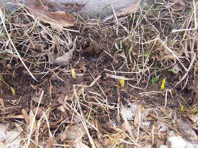
My aunts Sprouting Daffodils February 21st
Well I'm not the only one with Sprouting Daffodils! My aunt down the street from me also has Daffodils sprouting along the southern foundation of her home, But some of her were surprisingly over an inch high already! some were so quick to grow they starting growing right through the snow! Actually it was her Daffodils planted along the south side of her home that inspired me to do the same. Because hers always came up with the first late winter/early spring warm up She was not surprised by there early growth, She said they always come this early! But Cold weather will hold these back from growing too much.
The big story is actually a Winter Storm which will move south of our area Monday. Southern Wisconsin will get the brunt of that storm. to the North it looks quieter, with only a few flurries possible. Arctic Air will move south behind this storm Tuesday/Wednesday, Highs will only be in the single Digits in northern Minnesota to middle up upper teens southern MN and Wisconsin on Wednesday.
Local Forecast
Sunday: We will have Sunny to Partly sunny skies with highs in the lower to middle 30s. Enjoy!
for early this week we will have a little bit of snow but then Much colder temperatures by Tuesday and Wednesday. Monday a passing snowstorm to our south may bring some flurries or light snow showers in our area, But accumulations will be light, maybe a dusting, and even with the snow chance I would not be surprised to see filtered sun though out the day. Temperatures Monday will still be mild in the lower 30s, Lows in the mid teens Monday Night, then Tuesday as Colder air comes in, we will have the chance for some more flurries or light snow showers accumulations will be light. We will start off with fair temps, then Temperatures will fall. Lows will be Chilly Tuesday night falling below zero. Wednesday will be Cold as Arctic Air settles in Highs will only be in the teen, Lows will fall around the mid single digits below zero, this isn't Cold in Wisconsin Winter standards, but for Late February it is quite cold as highs are normally in the upper 20s to lower 30s this time of year. Daily forecast below.
Monday, Filtered Sunshine with a chance of flurries or light snow showers. Highs in the lower 30s. Monday Night, Flurries possible, otherwise Cloudy, Lows in the mid teens.
Tuesday, Turning Colder, Cloudy, with flurries possible. accumulations around a TR to maybe a half inch from both days of accumulations. Highs in the low 20s. Tuesday Night. Chilly, Mostly Cloudy lows falling to around -3.F
Wednesday, Cold, Clouds possible early then Clearing, Highs in the mid to upper teens. Wednesday Night, Cold, Clear Lows falling to the mid single digits below zero, Some spots may be colder.
Looking Ahead, Warmer late next week.
the brunt of the Arctic air really wont last long. as highs will already begin moderating Thursday. This is pretty common for this time of year, as Cold air has trouble staying around long because of our stronger sun. From Thursday through Saturday next week, Things look Dry, and even sunny, Highs will warm back to the upper 20s to low 30s by Saturday. then Sunday the 28th to Monday the 1st, the models show maybe some light snow chances, then a short cool down the 3rd/4th. Then I see Warming Temperatures around the 8th of March (My Birthday!) then towards the end of the forecast model run it shows Maybe a snowy system moving in. But it's too early to tell what will happen with this.
So to sum up the forecast ahead. I still don't see any Major cold and things looks fairly Dry with only small systems I see no snowstorms at this time.
Photos showing the exposed brown grass, Which has been getting noticeable the past couple days.
the past 3 days have brought just, Awesome weather to Western Wisconsin! We've had crystal clear skies, And highs in the mid to upper 30s for the past 3 days! Snow has been melting noticeable faster with this stronger sun. There are lots of big puddles on roads from melting snow! I've lost over and inch of snow in this weather, Our snow pack is now back down to 9 Inches.
Today highs really were nice! highs made it into the upper 30s,.Even low 40s were reported in a couple spots. My high was a nice 39.F, It really made it feel like spring! Here is a list of reported highs Thursday.
Daffodil Sprouts on the south side of my house Feb 18Th!
This is my first year with spring flowers planted on a southern exposure, so it is a new experience for me! but last spring, after visiting with my brother in Michigan. he offered me some daffodils bulbs, and I knew that planting on the south side of a building, would allow for early blooms! So I planted them on the south side of my house. So while I was outside enjoying the beautiful weather, I noticed some brown grass was showing on the south side of the house, So I decided to take a look and sure enough, Daffodils are sprouting! I also saw Crocus sprouting which I also planted last year, I knew they would be early but I never thought they would be this early!
photo showing how the snow melts on the south side of the house first.
So why is it plants bloom and grow earliest on the south side on buildings? I thought I would take the time to explain a little why: It's because The south side of buildings always receive the most sun, and sun reflects off the siding. It can hold warmth long overnight, Actually It can be up to 10.F warmer on the south side of buildings then surrounding areas especially when it's sunny! So this is why the South side of buildings/southern exposures always looses it's snow first. But it goes deeper then this. Basement Walls hold heat from our home, so this keeps the soil warmer for longer, even mostly unfrozen! (which brings my to my next story below) This creates a Micro Climate for plants growing on this side of buildings and promote early growth and flowers.
"lucky" Daffodil sprouts (after replanting) on the south side of our house Feb 18Th
So after finding the sprouting daffodils in one location, I decided to continue looking down the side of the house, And as I was inspecting I noticed the edge of a black pot, and a green sprout sticking out of a snow pile! then I remembered last year I bought a pot of daffodils from a local store, and I put then in a pot in a hole then partially buried them so they wouldn't fall over, I was going to plant them later. Well I had forgotten them, and they developed roots though the holes in the pot, and are now sprouting!
Photo showing what the daffodil pot looked like after spending nearly 1 year half in the ground notice the roots sticking out of the bottom!
Well right after I found them, I pulled them out of the hole, I was actually surprised I was able to get it out. Then I brought them in the house quick to take them out of the pot immediately! after I cut away the plastic pot, I brought them back to the side of the house, and stuck my garden shovel in the dirt and to my amazement, The dirt was un frozen, except for a small layer of ice on the very top! The dirt wasn't even cold like I would have expected! which is quite amazing with our cold winters. Our basement must keep the soil warm enough the prevent any thick freezing. These seem healthy, and even have multiplied in the pot! so I have high hopes for these. I'll keep watching as spring gets closer, and I'll keep everyone here updated. I'm sure it will be a Long time before I see any real growth from these after all it is only February. But by sprouting they are bringing some hope Spring isn't too far away, and if it gets cold again, I'm not worried, Daffodils are hardy will stop growing if it gets too cold, Then start growing again once temperatures warm!
A warm high pressure has been moving slowly east the past few days. This has brought us some pleasant weather and mild temperatures. It looks like this high pressure system will stick around for another couple of days. So look for mild and sunny weather too continue!
Local View.
This weather definitely got some people in the mood for Spring, I know it has me wanting Spring!
The high pressure system giving us this nice weather will be slow to move off, Whats this mean for the local area? It means more sunny beautiful weather! Look for a pleasant Thursday with sunshine and highs in the Middle 30s! Lows above zero in the upper single digits. Friday also looks sunny and quite nice, with highs in the lower 30s, lows in the single digits. Then Saturday, it will be cooler becuase of more clouds, withs highs in the 20s, and increasing clouds. Daily forecast below.
Thursday, Sunny and Nice! calm winds with highs in the mid 30s. Thursday Night, Clear, lows in the upper signal digits.
Friday, continued Sunny & nice! highs in the low 30s. Friday Night, Clear to Partly Cloudy, lows in the mid single digits.
Saturday, Sunny at first, Then increasing clouds. Highs in the upper 20s. Saturday Night, Cloudy, lows in the upper single digits.
Looking Ahead Forecast.
The forecast models are showing cooler temperatures, Dry but cloudy weather for the weekend. Highs will slip back to the chilly side, into the lower to middle 20s. But lows will still remain above zero. Between Monday Feb 22 and Feb the 25th The Models are still showing a coolish, but not cold and Dry weather pattern. then the 26th The models are hinting and increased chances for snow, and Warming temperatures. Then March 1st looks like it may be the start of a sires of warm-ups I talked about last week, The models show a nice Warm-Up the 1st. Then the models hint at some snow, but mild for the 2nd. Then, it looks a bit cooler but dry weather for the 3rd/ 4th of March. Then towards the end of model run, it shows another stronger warm-up, towards March 5th. This warm-up could be the first signs of shifting into a more Early Spring-Like weather pattern. It is a long ways off, and things will definitely change between now and then, but the models to seem to be consistent with a warm-up. But March can bring anything! please stay tuned as we get closer.
The past system was definitely, Interesting. It came right from the NE, from the U.P of Michigan has produced some quick snowfall totals across the area, and I mean Quick! Earlier in the day, it was Sunny with blue skies, but then in the matter of like an hour, by 3PM, skies clouded up and Moderate snow, with blowing snow began to fall by Sunset most places had an inch of the ground. then by Monday Afternoon, most places has recorded 2, to nearly 4 inches. I recorded a total of 2.25" with a 0.13" water content.
Here are a list of reported totals.
Chetek 3.70"
Conorsville 3.30"
Roberts 2.60"
Menomonie 2.50"
Hammond 2.50"
Clayton (my location) 2.25"
Baldwin 2.0"
St Croix Falls 2.0"
Sarona 1.20"
Front yard view Feb 15th
with accumulation of the new 2.25" of fluffy-like snow, my snow depth now stands at 10.50" With a water contend of 2.48" This is the highest Snow depth I've has since early January, This continues our constant snow depth over 6.50 inches deep, which seems unusual, We have had over 6.50" of snow on the ground since, December 9th! Also this is 4th time I've reached a snow depth of 10.50" the other 3 times, I reach 10.50 before it fell again We haven't been able to reach over that limit yet! but with the warmer months of winter already here, Maybe I wont reach that amount? only time will tell.
Things are about to get a bit more interesting across the Upper Midwest as a Moderate Winter system actually moves in from the Northeast! rather then the typical "East to West" flow. Minor accumulations will fall across much of Northern Wisconsin/ Southeast Minnesota, There might be more Significant accumulations across the U.P of Michigan, due to lake enhanced snow, Temperatures look Chilly for Monday, But then things warm back up with more sunshine Tuesday and Wednesday as things clear out.
Local View.
As attention is turned to this Wintry System this is what were looking at,
Light to Moderate Snow has already begun across the area Sunday afternoon, by Monday Morning Light snow will probably be falling. Light Snow to Moderate at times will continue through the afternoon Monday, But there shouldn't be anything too extremely heavy, But visibilities will still drop, and there will be some blowing and drifting snow Monday. Late Monday the snow will end so it is a fairly quick moving system Temperatures on Monday will be chilly compared to what is expecting this time of year, Highs will only make the lower to middle 20s.
Snowfall Accumulations.
This is what I'm thinking, The highest snowfall accumulations will be in Washburn, SE Burnett, Barron, Polk, NE Dunn and St Croix Counties, from northeast areas to southwest areas. in this area I'm thinking 3-4 inches is looking like a good possibility, but 5 inches isn't out of the question, NW Burnett and SE Dunn counties will probably be closer to 1-3 inches, but up to 4 inches is possible, Winds will be breezy out of the North neat 20MPH at times, so there will be some blowing and drifting snow, both Sunday Night and on Monday
Were looking at a warmer Tuesday & Wednesday, with clearing skies, and temps both days in the upper 20s, Which is what is to be expected this time of year. Tuesday may start of cloudy with some flurries, but it should become Partly Cloudy by the afternoon. Wednesday has the best chance of sunshine, It's not looking like a bad day at all Wednesday Partly Cloudy skies with highs in the upper 20s and light winds. Lows both days in the single digits above zero.
Daily Forecast.
Sunday Night, Light to Moderate snow at times, Breezy winds, with some blowing and drifting snow, Lows in the upper single digits.
Monday, A good chance of snow, Light snow most of the day, with Moderate snow possible at times. Total accumulations 1-4" up to 5" across the area, Breezy winds with some Blowing and Drifting snow, Highs in the lower to middle 20s. Monday Night, light snow or flurries, lows in the mid single digits.
Tuesday, Starting off Cloudy with possible some left over light flurries, then becoming Partly Cloudy with highs in the upper 20s, Tuesday Night, Partly Cloudy, lows in the upper single digits.
Wednesday, Partly Cloudy, Fair Temperatures, with highs in the upper 20s, Wednesday Night, Partly Cloudy, lows in the upper single digits.
Looking Ahead
This weekends Looking ahead forecast, continues to pretty good temperature wise, with still no Extreme cold in sight, with actually highs Moderating highs possible towards the lower 30s come Thursday, with Dry & sunny skies continuing actually Dry weather looks to continue into the next upcoming weekend, with Moderate temperatures.
looking even father ahead Sunday the 19 to Wednesday the 24Th looks Dry, with a bit cooler temperatures, but Nothing Cold. then February the 25Th, The models are hinting at a possible Snowstorm somewhere in the Middle of the country, This will continued to be watch as we go through the next couple of weeks. Temperatures look Moderate the 25Th, Then the 25Th through March 1st, The models have been hinting at our first late winter warm up the past week, It also looks more Active around that time, But this is still a long ways off and things will change so come back often!
Melting snow the past 3 days, adding moisture to the air, and night time lows just below zero this morning, along with calm winds, made for a perfect freezing fog event across parts of the area. I'm not sure exactly how much of the area saw freezing fog, but I do know at least all of the Western half of the area did, This was the second time this year that I've seen very thick hoar frost.
This was especially one of the more thicker hoar frosts I've see on pine trees, The needle's were almost completely hidden!
Look how thick it is on this Birch tree! I had a low of -1.F this morning, then after daybreak the sun broke out of the clouds and we had brilliant blue skies again! it was already in the low teens by 11AM
here is one last picture of the frost accumulation on our birch tree, The branches almost look fake!
Although we've had thick snowcover in Wisconsin for the past 3 months, I have been following something quite a bit more rare, This morning there was at least a trace of snow cover reported in every state in the Continental U.S from Wisconsin to Florida, California to South Carolina! This is actually quite rare, a Yahoo News Story said 65% of the U.S has snow cover right now, when normally just 40" to 50% of the U.S has snow cover! I myself have actually never seen so much snow covering the U.S Most years, I've notice this time of year the southern extent of the snow cover is normally around southern Iowa, and Central Illinois, but that is not the case this year! Much of the U.S has see a very snowy, and cool winter this year, even here in the local area, it has been notable snowy, I've received well over half of our normal winter snowfall already! Hopefully we will have a nice warm summer to make up for this!
I will end this post with a picture of the largest and closest River located to me, This is the Apple River, Which runs about 10 miles to my West, It runs from just north of Amery,WI though Somerset, before connecting to the St Croix River, You can see some Ducks and Canadian geese enjoying the open water! These geese never leave! The picture above was taken on the Apple River at Amery.
Were looking at a fairly Dry weekend for Most of the Upper Midwest, although a weak system will bring some snowfall to SW Minnesota and Western Iowa on Sunday, everyone else should be dry, Temperatures look fairly uniform to what is to be expected this time of year. Local View.
how many people noticed how much longer it's been staying light outside? I saw tonight it's been staying light out until 6PM! our days will continue to get longer as each day gains about 2 minutes of light each day!
Locally, Were looking at a Dry weekend ahead, With only a slight chance of a few Flurries on Sunday, but that is not likely, all 3 days will bring partly cloudy to partly sunny skies depending upon where you live. Temperature will be around Average for this time of year, in the mid to upper 20s, Sunday although with more cloud cover, will be a bit chilly in the lower 20s. Detailed Forecast Below.
Friday, Partly Sunny to Partly Cloudy skies, Dry, highs in the mid 20s. Friday Night, Partly Cloudy, Lows in the mid single digits.
Saturday, Partly Cloudy to Partly Sunny skies, Highs in the Mid 20s. Saturday Night, Mostly Cloudy lows in the mid single digits.
Sunday, A bit Chilly, Mostly Cloudy skies, may some flurries. highs in the low 20s. Sunday Night, Mostly Cloudy, lows in the Mid single digits.
Looking Ahead.
looking ahead, We will have some chances for snow as we start on Next Monday, but it appears light, with no heavy accumulations, light snow could last from Monday through Tuesday, then it becomes Dry for awhile Between Wednesday the 16 and Thursday the 18, Then Friday the models show more slim snow chances and some slightly cooler air, then from Friday the through Tuesday the 23rd it shows warmer weather moving in then from the 23rd onward through the 26Th, The Models again show some light snow chances, With steadily Warming temperatures.
but to some up this forecast, The models really show, Off and on light snow chances through the rest of Early to Mid Feb, No big snowstorms, and No shots of Real Cold anywhere in sight at this time, Hopefully the models continue this trend temp wise!
The Eastern Edge of a large winter storm effected the area the past 3 days. It really wasn't too bad here across Western Wisconsin, We had mainly off and on light snow showers the past 3 days, and total snowfall accumulations were not impressive. mainly up to 2 inches across the area, I only reported a grand total of 1.50" The main show was West of my area, into Central Minnesota, Where some places reported up to 10 inches in the Western Suburbs of the Twin Cities! Also up north along Lake Superior, where some places has some pretty impressive lake effect snow totals, See Tim's Weather blog for updates on that!
Our sidewalk drifted over.
The main problem with this storm was blowing and drifting snow, The snowflakes were quite tiny most of this storm, and temps were in the mid 20s, With winds blowing 25 MPH at times, This did make for the snow to blow around easily.
Image from GR3
I just has to point out, how there was a Warm Front that was actually coming out of the North! This system wrapped up some Cold air inside of it, This drug cold air right down into Western Iowa, While warm SE winds blew into most of Minnesota and Wisconsin, A Western Iowa town, just West of Des Monies were at -15.F While we were siting at 24 above! It's not often a warm from moves from the North to South. Eventually that warm from did continue south and east and gave Iowa some warmer temperatures.
Front Yard February 9th.
We've gained some snow cover over the past few days, and now, We have a very thick snowcover It now stands at 9.50 inches thick, I still needed a shovel to measure with, Some spots have more because of so much drifting we've had this winter! One thing I noticed this year, We have had such a constant snow depth this year! Last year, It was up and down, and I recalled at least once in the past 2 years, We've lost all or nearly all our snowcover around this time, before it built back up in March, This year that hasn't happened! this made many people believe we've had more snow then last year, But actually last winter by this time, We had 39.4 inches by this time in February, This year we've had about 37 inches, so pretty much right on target with last year!
I would also like to Announce that I have a new picture logo at the bottom of my blog, Which includes a sampling of most the Severe Weather photos I've taken in the past 2 years, Please take a look, and post any comments you have about that topic in the chat box off to the side! Thanks!
A Winter Storm has been impacting parts the Upper Midwest which started today, A Strong Clipper system will moved down from the north, and effected much of Minnesota, and Southern Wisconsin, This is where the highest accumulations have been so far shaded in orange above. Local View.
This Strong Clipper-like Winter Storm will continue to impact the local 6 county area, but nearly as severe as I first forecasted. The main area of low pressure was even more west then forecasted, This kept all of the heaviest accumulations west of the area, but the edge of the storm will still continue to effect the area For the rest of the winter storm, This is what will happen with the rest of the storm. Light Snow will continue off and on mainly in the Southern and western areas through at least the first half of Tuesday, the Heaviest snow will stay west of the area, winds will be Breezy from the SE which will cause some blowing and drifting.
Snowfall Accumulations.
Due to a shift to the west, I will have to cut down snowfall totals significantly. most areas will end out with 2-3" with maybe as much as 3-5" confined to Southwest St Croix County, Which will be closer to the heaviest snowfall. Daily forecast below.
Tonight, off and on light snow, lows in the middle teens.
Tuesday, a good chance of light snow or flurries mainly early in the day with breezy conditions, highs in the lower 20s, Total snowfall accumulations 2-5" Tuesday Night, Snow Ending, then becoming partly cloudy lows near 0.
No looking ahead forecast, but I can say it does look like things will quiet down for next weekend, it also looks colder.
We got quite a Active, Wet, couple of days ahead. we got a Weak system and Warm Front moving through for Friday and Saturday, which will bring some light snow, or freezing drizzle and Mild temperatures to most of the Upper Midwest, then Sunday, during the daytime, we will get a bit of a break, but skies will remain cloudy and it will cool down a bit, then late Sunday, we will have a second system develop right behind it, this one looks like it will have a bit more of a kick to it, it also looks like it will last longer, it will last through the 3 days forecast into Monday & parts of Tuesday, also looking yet even cooler into early next week.
Local View.
Overnight Tonight
We will have light Snow and Freezing Drizzle through the night, from a weak system and stationary front sitting nearby the area, a small glazing of ice is possible on roads, This could cause slippery conditions on roadways and this is what caused the NWS in the Twin Cities and Duluth,MN to issue a Winter Weather Advisory which is in effect for parts of the area tonight till 6AM tomorrow.
Then Friday, we will have off and on light snow or light freezing drizzle lingering through the day, Snow accumulations will be very light from this system, off and on light snow will last through Saturday, Snow totals from both Friday and Saturday will be light around 1 inch or less, Temperatures will be Mild for Friday, with highs in the lower 30s, but it will cool off a bit to more normal levels for early February for Saturday.
Late Sunday's System.
Sunday's and Early next weeks is the system to watch, because this one has the chance to bring a bit more snow to the area, Most of Sunday during the day anyway, will be dry as we get a small break from the snow. but skies wont clear out, and will remain cloudy, It's Later Sunday that our system will begin to Develop literally right behind our 1st one, This ones does appear to be a bit stronger, but because it lasts through and out of the 3 day forecast, I'll have to issued an updating Forecast on Saturday or Sunday. right now accumulations do look to be minor, but it will have to be watched carefully.
Daily Forecast,
Friday, Light Snow, or light freezing drizzle, Mild highs in the low 30s. Friday Night, light snow, lows in the upper 10s.
Saturday, light snow or flurries, Otherwise cloudy, with highs in the low 20s. Saturday Night, Cloudy, lows in the mid 10s.
Sunday, During the day, Cloudy skies with highs in the low 20s. then late Sunday light snow developing. Sunday Night, Light Snow, lows in the mid 10s.
Looking Ahead, I am still watching the system which will effect Mondays Weather, it looks as though a system will develop over North Dakota, then move East, this will produce some minor snowfall accumulations here in the 6 county area, This is why on Saturday or Sunday I will have an Updated Forecast issued so stay tuned. Temperatures, look to cool off behind this system as we get into a more northwest flow, it doesn't look terrible cold at this time, but it does look chilly. from February the 10th through the 13th. The models are very unorganized after the 13th, so it would be hard to pin point a long range forecast from this date.
Snow showers continued overnight and lasted into middle to late parts of the day, We had some pretty healthy snowfall totals for a weak system like the one that just past. It was bit more then I had forecasted for our area, but accumulations were still on the light side, Ranging from 1-3 inches across Polk, Barron, St Croix and Dunn Counties, Some spots in the north just as Northern Burnett and Washburn counties only got a dusting. as the sun was shining through the clouds and snow today, you could again noticed it has more strength, even though highs today were well below 32.F The barn roof in the picture above was 100% covered this morning! I recorded a high of 22.F
Fresh Front Yard snow cover February 2nd.
while reading Josh's blog( Oshkosh,WI weather blog) I got an idea, that I should take continuous pictures of my front yard to compare here at my blog! Today we got 2 inches of new fresh fluffy snow, this snow was very light and dry, it only had a water content of 0.04! The new snowfall accumulation made for a total snow cover now standing at 8.50" once again. With water content of 1.84" Snow cover here is very hard and crusty, just like Josh's snow pack, it is so hard that you can walk on it without falling through, and I had to require the use of a shovel to measure the total snow depth! This new snow accumulation did really freshen up our snow pack though.
Happy February 1st! Now, A small low pressure system will be exiting the area early Tuesday, minor snowfall accumulations between 1-3 inches will fall across southern Minnesota, Southwestern Wisconsin, and northern Iowa. after snow moves out skies will be mainly cloudy across the Upper Midwest, then we got partly sunny skies on our way for Wednesday, with more clouds for Thursday, Temperatures will moderate over the next 3 days.
Local View.
Tuesday, a weak system which started to effect the area Monday will begin to exit the area. Total accumulations from this system in our area will be light, with half inch to 1 inch total accumulations, it will leave skies Cloudy for the rest of Tuesday, before some clearing Tuesday Night, Wednesday skies will be partly Sunny, temperatures will begin moderating with lows in the lower 20s for Wednesday. Thursday, skies will be partly sunny at first, then we will get increasing clouds, high temps by Thursday will be approaching the mid 20s, Lows will be well above 0.F Daily forecast below.
Tuesday, Happy Ground Hogs Day! light snow early in the day, light snow accumulations half inch to an inch total, Then mainly Cloudy skies, Highs in the upper 10s. Tuesday Night, some clearing, warmer, lows in the mid single digits.
Wednesday, Partly Sunny Skies, a bit warmer, Highs in the low 20s. Wednesday Night, Mostly Cloudy, lows in the upper single digits.
Thursday, Warmer, Partly Sunny with increasing Clouds, but staying Dry, Warmer with highs in the mid 20s. Thursday Night, Mostly Cloudy, and Warmer, lows in the mid to upper teens.
Looking Ahead As we go into the 1st weekend in February, it appears like we have a better chance at some Snow Saturday the 6th, snowfall accumulations, if I had to guess early, I would say they could be 4 inch range, Temperatures look to be fairly steady, and near Average for this time of year, with highs in the 20s, then as we head into Tuesday the 9th through Thursday the 11th, Cold weather looks to make a come back for a short while then Friday the 12th, The model shows warmer weather returning and staying for awhile. Then by the 15th, the models show a strong system passing South of the area, Might get cooler again behind that system by the 16th, Remember the models are always changing and February can bring some pretty crazy weather, ranging from mild temps to bitterly cold! so please stay turned as we head through the upcoming weeks.


 Regional View.
 Local View.
 Garden View February 26
 Daffodils on the south side of my house February 26Th.
  Here is a group of an older variety of Daffodils I got from my brother from Lower Michigan, They don't seem to really mind our Wisconsin Winters!
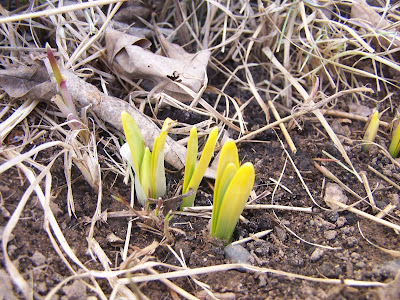 Daffodil Flower bud February 26Th.
 We can also see that the snow cover has really receded on the south side of the house compared to my last picture. Much grass is now exposed this is one way we can really tell that it warms up over here compared to the rest of the yard.
 Fridge project Hyacinths.
 Fridge
 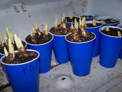 Yellow Daffodils.
.png)
 Local View.


 Daffodil Sprouts on the south side of my house Feb 18Th!
 photo showing how the snow melts on the south side of the house first.
 "lucky" Daffodil sprouts (after replanting) on the south side of our house Feb 18Th

 Local View.


 Look how thick it is on this Birch tree! I had a low of -1.F this morning, then after daybreak the sun broke out of the clouds and we had brilliant blue skies again! it was already in the low teens by 11AM


 Local View.
 Our sidewalk drifted over.


.png)
 Local View.


 Local View.