Map Image Legend Image

Iowa Weather Network Warnings Map

Iowa Weather Network Warnings Map

Winter Weather Advisory

Monday, October 29, 2012

Quiet weather this week. Calm weather lasting through Saturday. Next chance of rain, Sunday.

Photobucket
Regional Weather View.

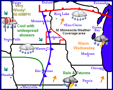
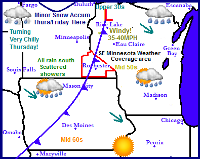
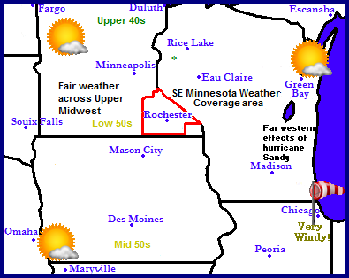
The big story this week is Hurricane Sandy effecting the Northeast. This weather system is so massive it's effects of high winds will be felt as far west as the Chicago area. The far western effects of Hurricane Sandy will effect the Lake Michigan area of Wisconsin and Illnoise with very high wind gusts up to 50MPH 1st thing Tuesday. Even across the Upper Midwest Wisconsin, Iowa and Minnesota winds will be turned north by the strong system. As a result of blocking from this same system weather across the Midwest will be dry and sunny for the rest of this week. There is no precipitation to speak of. Temperatures will actually be slowly warming through the week.
Photobucket
Local Weather View.

Photobucket
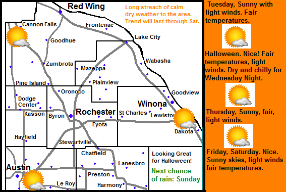
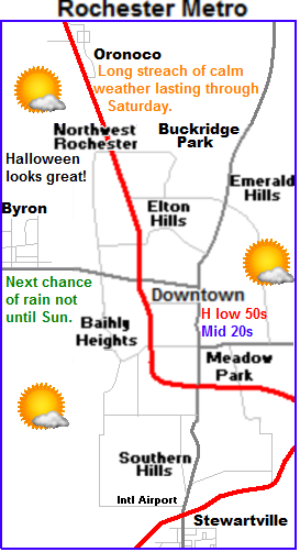
 Dry and calm next 5 days. Halloween looks great.


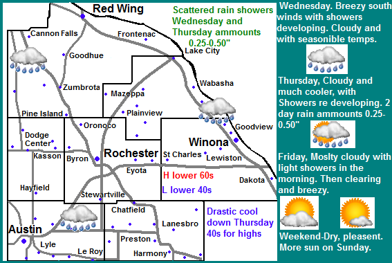
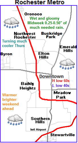
Locally we can expect a very quiet week in weather. Each day will mimicked one another. Tuesday through Saturday will all be very common with each day featuring a lot of sunshine with highs just below of above 50.F. Lows will also be very uniform in the middle to upper 20s to lower 30s. For Halloween. It looks sunny with highs in the low 50s during the day. Wednesday Night will be calm and cool, but typically for the last day of October. Lows  will be in the 30s. Saturday Night, clouds will increase ahead of our next chance of rain, which is Sunday. It doesn't look heavy at this time.


Tuesday, Sunny skies. Light north winds. Highs in the upper 40s to lower 50s. Tuesday Night, Clear skies, lows in the middle to upper 20s.

Halloween, Sunny skies, light winds with highs in the lower to mid 50s.  Wednesday Night, Clear skies, lows in the upper 20s to lower 30s

Thursday, Sunny, light winds, Highs in the upper 40s to lower 50s. Thursday Night, Clear skies, lows in the upper 20s to lower 30s.

Friday, Sunny, light winds, Highs in the upper 40s to lower 50s. Friday Night, Clear skies, lows in the lower to mid 30s.

Saturday, Sunny, highs in the upper 40s to lower 50s. Saturday Night, Increasing clouds with a chance of rain showers lows in the middle 30s.

Looking Ahead

Sundays shot of rain will be brief and light as a cold front sweeps through. It will dry out for Monday of next week featuring cooler temperatures. It stays on the cool and calm side through Wednesday the 7th. Thursday the 8th of November a weak system will bring the threat of rain and snow chances for the area. This system is a fast mover and does not look to heavy at this point. It will dry out briefly behind this for Friday, Before a much stronger more interesting low pressure system moves in for Saturday the the 10th. It shows a rather vigorous low pressure developing over Northeast Iowa before moving into Wisconsin. This for our area would have our weather start off as heavy rain Saturday the 10th, then a sharp cold front followed by heavy snow and high winds on Sunday the 11th. This could in a storm in the making, but things will certainly change before this date. Things look very cold for the week of the 12th, especially if we have a snowcover. It will remain dry an cool at least through the 18th. I will have more on the weather for later as models continue to change. Remember models change dayliy so things I saw in this post may not be valid days, or even hourly runs from now.


Thursday, October 25, 2012

Severe storms, Hefty Rainfall ammounts and light Snow seen in Southeastern Minnesota today as a sigificant cold front passed through. Quarter sized hail reported in St Charles

Photobucket

Morning thunderstorms around 6AM October 25th 2012

A big variation in weather across the area as a frontal system pushed through. Early this morning with fairly mild temperatures in the 50s and 60s throughout the area strong to severe thunderstorms developed along a cold front that was moving east. Some of these storms became severe in Western Winona county where quarter sized hail was reported at St Charles. Most of the storms remained below severe limits but still brought torrential downpours and vivid and frequent lightning. Beneficial rainfall amounts of rain were seen with many places getting over 1 inch. In some cases near 3 inches were seen. Temperatures were quick to drop  by mid morning cold air was pouring into the area with northwest winds that gusted to near 40MPH in some areas. Temperatures fell 15 to 20 degrees over the course of the day, starting off in the middle 50s at midnight and ending up in the upper 30s by 1pm. This temperature drop was enough to produce the 1st snow of the season at some spots. Cannon Falls reported light snow, and I personally observed snow falling while traveling between Zumbrota and Cannon Falls.  There were no other reports of snow from any other areas.

Severe Weather Reports

St Charles 1.00" quarter sized hail. 

Rainfall Reports & Wind gusts

 Red Wing 2.91"  29MPH

Preston 1.52" 36MPH

 Cannon Falls 1.46"  32MPH

 Lake City 1.38"

Byron 1.30" 39MPH

Dodge Center 1.28" 37MPH

Grand Meadow 1.27"

Zumbrota 1.12" 32MPH

 Austin 1.13" 39MPH

West Downtown Rochester-My Station 1.10"

Elgin 0.86"

Rochester Airport 0.84" 37MPH

Winona 0.78" 36MPH

Wabasha 0.68"


Decent rain today, but turing sigificantly colder as the day goes on falling through the 40s into the 30s. Don't be surprised to see light snow late today! Very cool and dry for the weekend 40s for highs. Updated X2

Photobucket


Regional Weather View Thursdays Weather Map

Weather has turned a bit more interesting across the Upper Midwest the past few weeks. Today a large weather system will pass through brining thunderstorms, rain and snow to the Upper Midwest. Warm temperatures will be found widespread throughout the  Eastern parts of the region today where thunderstorms are likely.On the cold side, snow will develop. With accumulations occurring in Western Miunnesota. Rain and storms could end as snow as far east as Eastern Minnesota and Western Wisconsin. Behind this weather system, calmer but cool weather will settle in for all areas for the course of the weekend.
Photobucket

Local views.

Note: The weather forecast has been updated to snow Thursdays snow potential


Locally, were going to go through several HUGE changes in weather this week. Thursday it will be turning much colder with a chance for snow, The weekend the end of the week will clear out but it will remain cool.  

Rain today possible ending as light snow-1st snow of the season! 
 
Thursday rain will be common through the day as temperatures start off in the 50s after midnight, strong northwesterly winds gusting to 35MPH at times. It will be significantly colder. temperatures will fall through the 40s into the 30s by the end of today. As cold air arrives and precipitation ends there is an increasing threat that it will end as light snow There would be no accumulations but becasue it could be the 1st snow of the season for many, it could be a surprising effect to see especially after receiving strong thunderstorms this morning.  Rainfall amounts from today will easibly be between e 0.50 to 2.00". Lows tonight will be in the lower 30s with strong northwest winds continuing. Friday will feel VERY cool, especially after what we will get this week. Highs on brisk Northwest winds Friday will only be in the lower to middle 40s. With lows dropping off into the 30s that night.

Thursday, Much Colder, Turning windy with winds gusting to 35MPH. Falling temperatures to the 30s Rain, possibly ending as light snow late in the day. No accumulations Thursday Night, Cloudy with lows in the lower 30s

Friday, Much Colder! Partly Sunny with highs in the lower to middle 40s. Brisk northwest winds. to 30MPH Friday Night, Partly Cloudy, lows in the lower 30s to upper 20s.

Saturday, Cool, not as windy Partly Sunny to Partly Cloudy. Highs in the lower 40s. Saturday Night, Partly Cloudy, lows in the upper 20s.

Sunday, Cool, Sun developing. Highs in the lower to mid 40s Sunday Night, Clear skies, lows in the mid to upper 20s

Monday, Sunny, highs in the middle to upper 40s. Monday Night, Partly Cloudy, lows in the upper 20s to lower 30s. 

Looking Ahead


Will be updated tonight.

Tuesday, October 23, 2012

Threat of Severe Weather Continues for Today Large Hail, Damaging and Tornados all included.

Photobucket


Image from SPC

The SPC continues a Slight Risk for severe thunderstorms in Central Iowa, Southeastern Minnesota and Western Wisconsin for Wednesday. This includes all of the local area. A very strong sigificant cold front will be raking across Minnesota later today, and with very warm moist and unstable air in place ahead of such a strong front, thunderstorms will break out later today most likely after 5pm just west of the area. These storms will quickly form into a line and some will produce some severe weather. The biggest threats will be large hail and damaging winds, but a tornado cannot be ruled out. Be sure to stay tuned to other websites for the most up to state information concerning this threat.

Tuesday, October 16, 2012

Very gloomy midweek- Showers likely Wednesday and Thursday with 0.25-0.50 of Much needed rainfall. Cooling down sigificantly Thursday, then warming back up and turning brighter for the weekend.

Photobucket
Regional Weather View

Continuing a more active streak here in the Upper Midwest this week with our next storm system entering in from the west, this time bringing the northern states much needed rainfall. A strong low pressure system will move across North Dakota into Minnesota. Spreading widespread scattered showers across South and North Dakota, Minnesota, Northeast Iowa, Wisconsin and Illinois. In the south thunderstorms will be possible. Behind this low pressure winds will become very gusty with wind gusts 50 to 60MPH. High wind warnings are in place for that region. As this system moves away over the weekend quieter, and warmer weather will move in for the weekend with warming temperatures to more seasonable normals.

Photobucket

Local view  and Metro view.

PhotobucketThis storm system for us will mean a chance to see much needed rainfall in which we have been lacking for quite a while now. Being on the southerly side of the system on Wednesday we can expect to a cloudy and warm breezy day Highs will be in the lower 60s and Winds will gust to 35MPH at times before the cold front pushes through. With the passing of this cold front showers will develop and push in during the day. These showers will be light, possibly moderate in nature, then the showers will end and there will be a break from the precipitation. Lows will be in the lower 40s. Thursday being behind the cold front will be significantly cooler with cloudy skies. We can expect highs only in the middle to upper 40s with breezy conditions at times. Showers and drizzle will re develop in the afternoon, and will be off and on from the late afternoon through the night. Total 2 day rainfall should be 0.25 to 0.50" with the chance for it to be more or less. Friday will be mostly cloudy with a chance of that rain continuing in the morning. It will be breezy with winds to 30MPH. The afternoon will remain cloudy with highs in the upper 40s to lower 50s. There may be some cloud breaks in the afternoon. Friday night will be Cloudy with lows in the upper 30s to lower 40s.

Brighter weekend

The weekend looks much brights and better for weather. We can expect Clearing skies Saturday with highs in the upper 50s, and lows in the lower 40s. Sunday will be the best day out of the 2 with a beautiful calm day with highs in the middle to upper 60s and lows in the middle to upper 40s.

Wednesday, Seasonable temps. Cloudy and breezy with winds gusting to 30MPH. Showers developing in the morning to afternoon. Highs in the lower 60s. Wednesday Night. Cloudy with lows in the lower 40s.

Thursday, Much cooler. Cloudy and breezy. Showers and drizzle developing in the morning to afternoon. Highs in the mid to upper 40s. Thursday Night, Showers and drizzle. Lows in the lower 40s. 2 day rainfall amounts ranging from 0.25 to 0.50.

Friday, A chance of rain or drizzle in the morning. Otherwise cloudy and breezy with highs in the lower 50s. Friday Night, Mostly Cloudy, lows in the upper 30s to lower 40s.

Saturday, Clearing skies.  Highs in the upper 50s. Saturday Night, Clear skies, lows in the lower to mid 40s.

Sunday, Pleasant. Sunny and  warm with highs in the mid to upper 60s. Sunday Night, Increasing clouds. Lows in the upper 40s.

Looking Ahead

Monday clouds will increase and the chance for light showers will again enter the picture, but they look fairly light at this time. Temperatures look to be seasonable.  Tuesday through Friday look clear and dry. With temperatures starting out seasonable on Tuesday seasonable and ending out quite warm on Thursday. We could have highs in the 70s. Saturday and cold front pushes through bringing very little rain with it. Sunday looks cloudy and cool. Monday the 29th is the next interesting storm system in the models. Even more interesting, it has been showing a few runs now which may indicate some consistency.  It's showing a low pressure system going from Nebraska to Minnesota, spreading heavy rains, and high winds across the region, with far Northwestern Minnesota dealing with snow and wind. Thunderstorms are a possibility in our area. Tuesday the 30th looks significantly colder behind this storm. With below freezing highs a possibility. It remains on the cooler and dry side through November 1st.


Saturday, October 13, 2012

Cold Temp Report-Friday mornings lows as cold as the upper 10s reported! Also worsening drought condtions across all of the area. Mower county now in Extreame Drought. Moderate to Severe drought everywhere else.

Photobucket
Frost back yard October 12th 2012

Temperatures bottomed out to their coldest levels of the season so far, dropping to the teens to lower 20s across much of the area which is more typical of November. Average lows are expected to be in the upper 30s to lower 40s this time of year. The cause of the cold air was the passes of a cold front bringing in cooler Canadian air from the northwest. The low at my station was 24.F which is the coldest so far of the season. An interesting fact that I noticed with this cold snap is the airport in the country fell to 27.F while here in the city the low was 3 degrees colder at 24.F. This is the first time during a cold snap that I've actually seen a low temperature colder in the inner city areas they the outlying airport.

Photobucket
 Lows reported Friday Morning.

The coldest temperatures were in the northern areas and river valleys. Cannon Falls and Zumbro Falls both had lows in the upper 10s. Warmest temps reported were of that in areas in the south and along the Mississippi River.

 Photobucket
Image from U.S Drought Monitor

As another shot of what was supposed to be promising beneficial rains misses the area, Drought conditions are becoming a serious factor here in Southeastern Minnesota and many are wondering when this streak of dry weather will end. Dry conditions seemed to have started over a year ago in August of 2011. Since that time rainfall has been un reliable going from having enough rain to not enough very easily. Decent summer rains across the area were only in spotty areas at best that were lucky enough to get in on some of the summer thunderstorms that we had. But in September it turned very dry and many areas are now way below normal for both September and October so far. The NWS in La Crosse has been keeping very good track on the drought conditions as they have continued to develop. NWS La Crosse says rainfall deficits since January 1st in some of the worst areas range from -10.95" at Austin to -7.44" at the Rochester Airport to -7.63" at Preston If you go back to around when the drought started in  2011 deficits go as high as -19.51" for Austin -15.48" for Rochester Airport and 15.75" for Preston.  Soil moisture levels across the area are very low and recent rains that have only seemed to "spoon feed" the soil are not helping much in the way of reducing drought. Hopefully we can continue to get into a long term wetter pattern that can bring healthy rains back to Minnesota.

The map above shows  certain parts of counties in the following status

Extreme Drought For the Southwestern 1/2 of Mower County effecting Austin and surrounding areas.

Severe Drought For Southern Dodge, Northwestern Mower, Southern Fillmore, Eastern Winona, Eastern Wabasha counties.

Moderate Drought For Goodhue, Olmstead, Northern Dodge, Western Wabasha, Western Winona, Northern Fillmore counties.

Friday, October 12, 2012

Rainfall ammounts decreasing for Saturday as system trends south, but Showers and thunderstorms still expected with ammounts 0.25-0.50" Warmer and sunnier for the start of next week highs near 70.F Next chance of rain: Wednesday.

Photobucket
Regional Weather view.

The regions next weather maker will be the main story in the states of Iowa and Wisconsin as a fairly strong low pressure system tracks from Kansas across Iowa and then into Wisconsin. This feature will spread widespread showers and thunderstorms with heavy rains across Eastern Iowa and Southern Wisconsin. Severe weather with damaging winds, hail and tornados are possible mainly in Southern Iowa, Illinois and Southern Wisconsin. There will be a sharp cut off in the rain to the Northwest where most of Minnesota and Northern Wisconsin will miss out on the bulk of the heaviest rains.
Photobucket

Local and Metro views.

Note: The forecast has been updated.

PhotobucketSaturday Rain, will continue to be the biggest story local area. The low pressure system tracking across Iowa is forecasted to bring rains even here in Southeastern Minnesota. Unfortunately models have significantly decrease amounts because the system has been trending further south. The severe weather risk is also now very low. Showers and look to start Friday Night and will be off and on all throughout Saturday into Saturday night. Even though amounts have been lowered it will still be the most rainfall we've seen in a month with amounts ranging from 0.25 or less in Northwest areas to around 0.50 in Southeastern areas, with possibly a bit more in localized areas. Sunday there will still be a chance of showers in the morning, otherwise we can expect dry conditions with partly sunny skies. Winds will be quite gusty Sunday out of the Northwest up to 30MPH. Highs will be in the lower 60s with lows in the upper 30s to lower 40s. Monday will be much nicer and even quite warm as well. We can expect sunshine to return with highs approaching 70 degrees, we can expect a much warmer night with lows in the upper 40s Monday night as clouds increase. Tuesday will be fairly cloudy, but highs will still be in the upper 60s to lower 70s range. Lows will remain in the upper 40s to lower 50s area.

Next shot of much needed moisture.

Wednesday is the next shot of moisture in which all of the area desperately needs. At this time it does not look like much maybe around 0.25" but this is our next chance of rain. Highs will be in the lower 60s with lows in the lower 40s because of the expected rain and clouds

 60s with lows in the lower 40s
Saturday, Showers and thunderstorms off an on through the day. Highs in the upper 60s. Saturday Night, Showers. Total event rainfall amounts around 0.25" to 0.50" Lows in the upper 40s.

Sunday, Breezy, Winds gusting to 30MPH Partly sunny with clearing skies. Highs in the lower 60s. Sunday night. Partly cloudy with lows in the upper 30s to lower 40s.

Monday, Sunny and warm! Highs in the upper 60s to lower 70s. Monday Night, Partly Cloudy, lows in the mid to upper 40s.

Tuesday, Partly cloudy to partly sunny. Highs in the upper 60s to lower 70s. Tuesday Night, Increasing clouds, lows in the upper 40s.

Wednesday, Cloudy with a chance of light rain showers. Highs in the lower 60s. Wednesday Night, Cloudy, a chance of light showers. Lows in the upper 40s. 

Looking Ahead

Even though the models have trended this weekends more southward with this weekends the still seems to be a signal a significant change to a wetter pattern. The models continue to show multiple chances for rain for the rest of the month. After Wednesday it is calm and warm through Friday, then a dry cold front passes through cooling things down on quite cool on Sunday the 21st, then it warms back up to seasonable levels Monday the 22d with a small change a few rainshowers around. Then around Wednesday October 24th a much stronger storms system arrives. Models show a large low pressure system tracks from Iowa through Central Minnesota, spreading widespread rain and thunderstorms in our part of the state, and even heavy snows in Northwestern Minnesota and North Dakota. Very cold air and very windy conditions follow this storm Thursday the 25th, highs may struggle to get above 32.F. More calm weather follows this system as we near the end of October.


Severe weather risk Saturday

Photobucket
Image from SPC

A Slight Risk for severe thunderstorms has been issued for the Upper Midwest including all of the local area. A low pressure system will tack through Minnesota trailing a cold front that spark thunderstorms from around the Twin Cities southward through Southern Minnesota into Iowa. There is a chance that some of these storms could develop large hail and damaging winds, and a chance for a tornado. Heavy downpours are also a risk by these storms. The best chance of severe weather will be if we can get some afternoon sunshine, and the timing of the storms will be in the afternoon. People should be aware there is a chance that a few storms could become strong severe tomorrow.

Sunday, October 7, 2012

Cold temp report, morning lows this morning as lows dropped as cold as the lower 20s. Peak Fall Color being seen at all areas this week.

Photobucket
Fall color report October 7th 2012

Fall color is peaking across the area this week. Sugar Maples are nice and Red Maples are amazing in some areas, Poplars, Oaks, Sumacs have all turned. Earlier changing trees has past their peak are leafless. Dry summer conditions have really taking away out chance at a beautiful fall foliage season here in southern Minnesota. Most colors are rather dull and are just not vivid.
 Photobucket
Our street October 7th 2012 Yellow Honey Locust.

 Here in Rochester colors have peaked were at 100% color, but when you look among the landscape you can see a wide range of colorings, from areas where most trees are bare, to some ares where trees are still very green. Over all the colors are very dull here in Rochester. Nothing really has stood out to me at all, especially after being in Wisconsin and seeing the colors in that area.
Photobucket

Morning lows October 7th.

This morning was quite cold across the area as a Canadian high pressure settled in the area and skies cleared. Low temperatures where clouds cleared first fell to as cold as the lower 20s are Austin and Dodge Center. Areas where clouds held on longer allowed the temperatures to stay in the upper 20s to lower 30s. Regardless of where you were this was an area wide hard freeze. In our yard the temperature fell to 28.F. All tender plants were hit hard and the growing season has officially ended.

Tuesday, October 2, 2012

Sharp Cold Front, Sigificant cool down by Thursday. Highs cooling to the 50s With Several hard freezes are likely over the weekend.

Photobucket
Regional weather view.

A storm system will be making the top of the news story in the Upper Midwest over the end of this week as it makes its way through the Upper Midwest bringing significantly colder temperatures region wide. The low pressure system is expected to track across Northern Minnesota and Wisconsin.  Enough cold air will flow in behind this system that areas Northwest of Duluth will see their 1st accumulating snowfall of the season, which could pile up to a few inches in that area. Most of the precipitation will be very limited to Northern Minnesota, across the south it will only be a few scattered rain showers. Sharply cooler temperatures will be the largest effects in these areas.

Photobucket

Local view.


Locally effects will be mostly limited to the sharply cooler air behind this system and cold front. Highs Friday ahead of this feature will be near 80.F before the front passes through, Thursday highs will struggle to reach the middle 50s, and winds will be strong out of the Northwest gusting to 30MPH. It will also be cloudy with a few scattered showers here or there. There is little expected in the way of rainfall across our area, it will mostly be of the hit and miss variety with amounts totaling under a quarter inch. Thursday night we will start having lows dip into the 30s for the 1st time of several coming nights which will likely prove to bring several frosts of hard freezes by weeks end. Friday will have clearing skies. It will be breezy and cool with highs only in the lower to middle 50s area wide. Friday night we will have partly cloudy skies with lows dipping into the upper 20s and lower 30s. Saturday/Sunday we can expect chilly sunshine with highs only in the upper 40s and lower 50s even with strong sun. Low temperatures both Saturday Night will be in the upper 20s area wide and it is possibly a few middle 20s will be seen. A hard freeze is likely, including in protected areas and inner city areas of Rochester. Sunday temperatures will start to moderate towards the middle 50s with lows in the middle 30s.

Wednesday, Mild and sunny! Highs in the upper 70s to lower 80s. Wednesday Night, A chance of a scattered shower. Lows in the low 50s.

Thursday, Scattered Rain Showers possible Much cooler, Strong Northwest winds gusting to 30MPH. Highs in the middle 50s. Thursday Night, Mostly Cloudy, lows in the upper 20s to lower 30s.

Friday, Breezy, Partly Sunny then clearing. Highs in the lower 50s. Friday Night, Partly cloudy skies. Lows in the upper 20s to lower 30s.

Saturday, Chilly sunshine, highs in the upper 40s to lower 50s. Saturday Night, Clear and cool. Widespread hard freeze likely, Lows in the mid to upper 20s all areas.

Sunday, Chilly sunshine, Highs in the upper 40s to lower 50s. Sunday Night, Clear, Warmer, lows in the low to mid 30s. 

Looking Ahead

Unfortunately there is no significant rain in sight  for the next few days. Tuesday is our next shot with a passing weak system but it looks minimal at this time. Things finally start to get more promising for precipitation towards the end of the week of October 11th but it also gets interesting. Models show a fairly strong low pressure system tracking across Northern Minnesota southeastward towards Upper Michigan. Its showing a threat of accumulating snow in Northern Minnesota October 11th, with widespread rain possibly changing to a few snow flurries even in our local area. A significant cool down follows this system. If the models continued with this system it has potential to bring desperately needed rains to our area. After Friday October 12th it turns much warmer and drier again, and we fall back into the pattern through the 18th. Forecasting models change day by day so be sure to check weather outlets often.

Monday, October 1, 2012

Fall Color Report #5 Peak color being reached at Cannon Falls, Red Wing, Dodge Center and Austin. High Color everywhere else.

Photobucket
Fall Color Report # 5 October 1st 2012

Fall colors are increasing faster then I can keep up with them! Many spots have blown off the "moderate color" stage and have either went to high color or color is peaking! In areas of Goodhue, Dodge and Mower counties, fall colors are at peak and colors are beautiful! Areas in Olmstead, Fillmore, Wabasha and Winona counties will be peaking in the next few days.

Photobucket

Burning Bush St Marys Park October 1st 2012

Fall color here in Rochester I would say has jumped to 75%  Fall color here in Rochester is nice, but it does not seem like they are very vivid just yet. I just came back from a trip from Northwest Wisconsin over the weekend and in that area, color is very stunning! Around Rochester early changing trees like Ashes and Maples are at peak color and are very beautiful at this time, shrubs like Burning Bush and Sumac are also peaking. I've seen, yellow, red and orange. Mid and Late turning trees like Poplars, Birch and Oaks are also now starting to join the show turning colors of  golden yellow and orange. Fall color is very nice

Photobucket
Fall color in my neighborhood Honey Locust, Red Maple October 1st

Fall color is my neighborhood is nice, but rather bland because all the trees turn yellow for the most part.

Photobucket
Fall Color in Sugar Maple

Sugar Maples are famous for their beautiful colors in which they turn. Color in these trees can range from red to orange to yellow, or a combination of the three!