Map Image Legend Image

Iowa Weather Network Warnings Map

Iowa Weather Network Warnings Map

Winter Weather Advisory

Wednesday, May 30, 2012

Cool wet and cloudy Thursdays with highs only in the upper 50s! Increasingly nice by weeks end with sunshine and highs in the 70s.

Regional weather view.

A cool and cloudy pattern for the Upper Midwest for the end of this week. A low pressure system scooting over Illinois will continue to spread light rain and below average temperatures across Southeastern Minnesota, Iowa, Wisconsin and Illinois. Highs will only be in the 50sto 60 across the region. By weeks end a high pressure system will bring in sunnier weather and warmer temperatures into the 70s and 80s by early next week, which is closer to normal.


 Regional and Metro views.

Locally it will be downright awful for weather on Thursday, It will be cloudy and chill with off an on drizzle early. Then lingering cloudy skies in the afternoon. Highs will only be in the 50s because of dense cloudcover which is well below normal Night time lows will be very chilly in the middle 40s. The weather will drastically improve by Friday  as a high pressure system slides into the state and scours out the clouds and replaces it with sunshine. We can expect highs to be in the 70s on Friday as well as Saturday. Saturday should be mostly dry with partly cloudy skies and light winds. We don't run into our next chance of rain until; Sunday and Monday when a frontal system brings spreading shower and thunderstorm chances back into Minnesota. The rain with these chances do not look at all heavy. Temperatures during this time will be much more summer-like with highs in nearing 80 and lows nearing 60. 


Thursday, Chilly! Cloudy with off and on drizzle early then cloudy. Highs in the upper 50s. Thursday Night, Cloudy skies. Lows in the mid 40s.

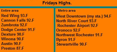
Friday, Warmer and pleasant. Sunny skies with highs in the lower 70s. Friday Night, Clear skies lows in the low 50s.

Saturday, Partly Cloudy and nice with highs in the lower 70s. Saturday Night, Clear skies lows in the mid 50s

Sunday, Sunny with a slight chance of a shower or thunderstorm late. Highs in the upper 70s to low 80s. Sunday Night, A slight chance of showers and thunderstorms lows in the middle 60s.

Monday, A chance of showers and thunderstorms otherwise sunny with highs in the low 80s. Monday Night, Clear skies lows in the middle 60s

Looking Ahead

By Tuesday our weather pattern is sunny more humid warm to very warm days and warm nights and it appears dry with little chances for rain. This pattern sticks around through Saturday June 9th. It really looks hot, dry and sunny for the weekend of the 10th. This model run actually drys to keep it dry, hot and sunny through the 15th of June. I do not really trust that this to be true. I would suspect that after about a week or so into the warm patter we should run into rain. More on this later.

Monday, May 28, 2012

Hot Sunday highs in the 90s with dewpoints in the 70s. Also severe storm effected Goodhue County with strong winds.

 Humid conditions in the bluffs North of Rochester Sunday Morning May 27th.

Sunday was a hot and humid day for the region as a very summer like warm front pushed through the area early in the morning and left us with sunny, hot and humid conditions. Dewpoints actually topped out in the lower 70s early in the morning before things dried out slightly. Many areas had their warmer temps of the season so far, 90s were widespread. Here at my location yesterday it was 93.F the 4th time it has been above 90.F and the 2nd time its been in the middle 90s. The warmest day so far goes to May 18th with when rose to 94.F
Highs Reported

Goodhue County storm.

Yesterday evening severe winds impacted parts of Goodhue County as a gust front pushed through the entire area. Storms influencing with this front enhanced the winds in some areas and at Cannon Falls there was a reported wind gust of 61MPH. No damage was reported.

Wind Reports

Red Wing 45MPH

Cannon Falls 61MPH

Wastedo 50MPH

Saturday, May 26, 2012

Severe Storms effect Dodge County and go on to effect the Rochester area as strong storms. Tornteial rains 1.73" in a short timespan at my location

Shot of heavy rain and gusty winds in Northern Rochester-Buckridge Park area May 26th 2012

Severe Thunderstorms impacted the area once again today, although the time it effected western and central parts of the area with severe hail, gusty winds torrential downpours. Thunderstorms were ongoing in Western Minnesota this morning around 9am. The storms continue to track down a frontal boundary east through mid morning hours and finally entered the local area around 11am when they really begun to strengthen east of Owatonna.

 Radar image as the storm was effecting Dodge County. Screenshot courtesy of a friend who was helping out

As the storms strengthened severe hail larger then quarter sized was reported near Claremont in Dodge county after this report this storm continue to push down highway 14 effecting communities along highway 14 and eventually into the Rochester metropolitan area where it brought torrentially heavy rains, lots of penny sized hail and gusty winds. There were lots of reports of penny sized hail in areas of Rochester south of West Circle Drive and 55th street NW including the Downtown area where dime sized hail was reported along with a windy gust of 40MPH at St Marys. I was in Northern Rochester where I work where very heavy rain and gusty SE winds were seen along with lots of lighting but no hail was seen, but I heard from family and locals that "very heavy rain and hail so hard you could barely see" was predominant in the Downtown area and my neighborhood. When work ended I came home to 1.73" in my raingauge, all of which fell in a 30 minute time span! Urban Street flooding was and issue for during the rain. There was lots of washouts in driveways and industrial lots around the city and you could tell the streets were filled with water when the heavy rain occurred. Ditches were full along highway 52 where could see standing water on top of brown grass from previous drought conditions.

Storm Reports

2 miles S Claremont 1.25" hail

Byron 0.75" hail

Kasson 0.75" hail

3 miles SW Rochester 0.75" hail

West Downtown Rochester 0.50" hail also heavy rain 1.73" fell in short time

2 miles S Claremont Heavy Rain 1.73"

2 miles W Eyota Heavy Rain 2.16"

Dodge Center Heavy Rain 1.89"


Friday, May 25, 2012

Severe Weather Threats Tomarrow and Sunday

Image from SPC Saturdays Severe Weather Risk.

The SPC has issued a Slight Risk for severe storms Satruday, including all of the local area A warm front will be pushing through the Upper Midwest Satruday thunderstorms will be on goining from the overnight hours across our area and at any time some of the storms could become sever with strong a threar for tornados and heavy rain. People should be aware there is a threat for severe thunderstorms on Saturday.

Image from SPC Sundays Risk

The SPC has issued a Slight Risk for severe storms Sunday including the entire local area. A very warm very humid airmass will be in place as a sharp cold front pushes through the state. Thunderstorms will break out in Western Minnesota and likely develop into a line of storms that will push into our area in the night time hours, Damaging winds, large hail, tornados and torriental rain with 1.0+ ammounts are possible from these storms. People. should be aware severe thunderstorms are a possbility after dark Sunday. More information will be released in the coming hours.

Multiple threats for severe storms Satruday through Sunday! Heavy rain also a possbility. Before storms Sunday very/humid weather expected mid 90s with 100+ heat index values!

Regional Weather View.

Lots of types of weather becoming big stories  in the Upper Midwest this weekend. The main one will be the threat of severe storms Saturday and Sunday with a warm front/cold front combination. Satrudays threat will be with the warm front in Wisconsin, Northern Iowa and Minnesota. Sunday the severe weather threat will rake across Minnesota, Northern Iowa and Wisconsin again before ending. Heavy rainfall is a possibility especially places in Minnesota that do not need the heavy rainfall. Sunday will likely be the hottest day of the year for many locations as mid 90s are likely across much of Southern Minnesota, Iowa and Wisconsin south of a warm front. High dewpoints will lead to 100+ value heat indexs.

Local and Metro views.

Saturdays Severe Weather Threat

Locally we will be in some of the brunt of the multiple weather stories expected for the long holiday weekend. First a warm front that will bring very hot weather Sunday will be working through will bring thunderstorms in the early part of Saturday. Some of these storms could be severe mainly with strong winds and heavy rain. The threat for rain will decrease after 2pm then rest of Saturday will be cloudy and humid with highs in the 70s and lows remaining near 70.

Very Hot Sunday 95.F temps 100+ heat index values!

Sunday a very hot and humid airmass will be in place. Under sunny skies with strong south winds gusting to 35MPH high temperatures will reach the their warmest levels of the season hitting the middle 90s. It is possible some spots may reach the upper 90s especially in cities and general hot spots.  With temps expected to be this high with dewpoints very rich and sticky in the mid 60s to near 70 will cause heat index values to raise to near 100.F or higher. Heat realated stress can occur with tempetures this high. Residents should remember to stay cool in these types of conditions

Sundays Severe Weather Threat

Sunday has the highest threat  of seeing severe storms as a cold front plows into the hot humid airmass that will be in place. Thunderstorms are expected to break out across Southwestern Minnesota and moved east across the entire southern part of the state, likely reaching our area near dusk or after dark. Damaging winds, tornadoes, large hail and Torrential downpours will all be a possibility with these storms. Rainfall ammounts for the weekend total could exceed 1.50" in some areas. Satruday and Sunday will be both days to keep a weather radio handy. Monday after a threat of showers and thunderstorms early it will begin to calm down weather wise and cool off Highs will be in the upper 70s Monday with lows in the mid 50s, by Tuesday we can expect sunny breezy cool conditions with highs in the 60s and lows slipping into the upper 40s.

Saturday, Humid, Showers and thunderstorms in the morning. Some could be severe and produce heavy rain. Highs in the upper 70s. Saturday Night, Cloudy and humid with lows in the low 70s

Sunday, Hot and very humid! Sunny with highs in the middle to upper 90s. Heat Index Values around 100. South winds gusting to 35MPH. Sunday Night Thunderstorms, Some could be severe and produce torrential downpours. Lows in the upper 60s.

Monday, A chance of showers and thunderstorms early then partly cloudy with highs in the upper 70s. Monday Night, Clear skies lows in the low 50s.

Tuesday, Cool and breezy. Sunny with highs in the upper 60s. Winds gusting to 35MPH Tuesday Night, Clear skies and chilly, lows in the upper 40s.

Looking Ahead

   The weather looks drier and more seasonable for the middle part of this week. It looks typical for early June with dry sunny weather and highs in the 70s. Heat and humidity slowly increase until it becomes very hot by Monday the 4th of June ahead of a cold front that brings a chance of thunderstorms by Wednesday June 6th. After the a frontal system separating summer heat and cooler temps remain over the area meaning that there will be several chances and thunderstorms from the 7th through the 10th. and temps will be up and down with some days being hot humid and stormy while others will be cooler and more seasonable and rather cloudy. There could be several threats of severe storms and heavy rains during this time as well. We stay in the pattern through the 11th of June. 


Thursday, May 24, 2012

Severe storms hit Winona and Fillmore counties hard. Widespread tree damage reported in Winona. Also Hot and very windy Wednesday ahead of front wind gusts over 50MPH reported!

Torrential downpour from a afternoon an afternoon strong storm May 24th 2012

Strong to severe storms swept through the area today as a stationary front got its act together and finally pushed east. Thunderstorms formed along this front along I-35 and slowly gained in strength as they moved east. After producing heavy downpours and gusty winds through communities west of and along highway 52 including in Rochester, they became severe and produced very high winds and widespread significant tree damage in Fillmore and Winona counties. A gust of 64MPH was reported in Harmony, and trees and powerlines were down in Fountain. Some of the worst damage done in the area was around and in the city of Winona. Strong winds down trees throughout the city. Powerouteges were reported in Goodview a Winona Suburb.


Radar image as storms approached Winona

This is a radar image taken from NWS La Cross as the storm pushed into the city of Winona. Notice a nice but un defined edge bowing area on the storm

Reports

Winona Widespread Tree Damage

Goodview, Trees down Power Outages.

Harmony, 64MPH wind gust Trees Down

Fountain Trees and powerlines down on Main St


Wednesdays Hot weather and strong S winds. 
 
 Significant blowing dust near Hayfield May 23rd 2012

The passing of a warm front and s strong low pressure system to our north with a tight gradient set us up for a hot and hot and very windy Wednesday! The wind was a hot, dry and very strong out of the South all day. It especially became strong in the afternoon when they were gusting across the Southern Minnesota Plain from 45 to 50MPH. The wind made driving difficult and causing minor problems such as breaking tree limbs and loose items blowing around. Significant blowing dust was a problem as well as dry conditions and Freshly plowed fields was allowing the winds to pick up the soil and blow it into the air. I personally was driving west during the day and I've never seen soil being picked up like this off fields it was a neat thing to see. In some cases the dust was blowing so bad that it was difficult to see where it was blinding views on roads at certain fields.


Highest wind gusts and temps.

The highest wind gust seen was in open areas near Zumbrota where a gust of 51MPH was reported. The least windiest area was Winona which recorded a 30MPH gust


Moderate risk for severe storms today! Tornados, High winds and large hail all a possiblity with the storms.

Image from SPC

The Storm Prediction Center has issued a Moderate Risk! for severe thunderstorms in Southeastern Minnesota and Wisconsin. This includes the entire local area! A stalled out stationery front over central Minnesota will move southeast and will be the focus for thunderstorm develop in the afternoon. These storms could quickly become severe and produce very high winds, large hail and heavy rain. Upper level winds also show an enhanced threat for tornadoes. People in the area should be very aware that there is a fairly high threat for severe weather this afternoon which could prove to be dangerous!

Wednesday, May 23, 2012

Severe weather threat for Thursday

Image from SPC

The SPC has issued a Slight Risk for severe thunderstorms across parts of the Upper Midwest for Thursday. This includes most of the central and eastern part of the local area. A slow moving cold front will push through east. Thunderstorms are expected to develop along this front in the afternoon. Storms could become severe with large hail, gusting winds, along with a tornado threat. Heavy rainfall is also a possbility. Stay tuned to local weather sorces for Thursday!

Monday, May 21, 2012

Warm but nice Tuesday. Then increasingly very warm humid with threats of much needed rain Wed/Thurs.

Regional weather view.

A typical pattern more for June! Increasing heat and humidity will start to push in Tuesday ahead of a frontal system. Temps will warm to near 90.F across much of Iowa and Southern Minnesota. This will feed the threat for developing thunderstorms Wednesday and Thursday. Heavy rain is possible in Central Minnesota where the light green lines are over 1 inch amounts are likely and some of the storms could be severe.


Local and Metro view.

We can expect one more nice, but warm windy day Tuesday before we can hopefully get in on some much needed rainfall in the form of Thunderstorms Wednesday and Thursday. For Tuesday skies will be sunny with warm temps hitting the 80s. Winds could gust to 35MPH out of the south. Wednesday it will be turning very warm and humidity will begin to increase. Wednesday during the day will be warm and sunny with highs in the middle to upper 80s and lows in the 60s. Thunderstorms will develop in the afternoon to our west and could move in overnight a they weaken. A few of them could be strong before weakening. Thursday will have the best chance for rain. It will be warm and humid and windy with gust to 35MPH during the day with highs in the mid 80s and dewpoints in the 60s so it will feel sticky. Thunderstorms will develop in the afternoon and evening, a few of these could be strong maybe severe, but widespread severe weather is not expected. Thursday Night, will be the best chance of thunderstorms from storms in the evening, then it will be cloudy with lows in the middle 50s. widespread rainfall amounts are expected to be 0.25" but it is very possible there could be much higher amounts in heavier storms.

Tuesday, Sunny, warm and windy. South winds gusting to 35MPH at times. Highs in the low to mid 80s. Tuesday Night, Partly Cloudy lows in the low 60s.

Wednesday, Sunny, warm and windy. South winds gusting to 35MPH Highs  in the mid to upper 80s. Thunderstorms forming late in the day. Wednesday Night, A chance of thunderstorms some could be strong, otherwise cloudy with lows in the mid to upper 60s

Thursday, Sunny, warm, windy and humid. South winds gusting to 30MPH Thunderstorms developing in the late afternoon some could be strong. Thursday Night, Thunderstorms. Some could be strong. Lows in the mid 50s.

Friday, Mostly Cloudy and cooler. Highs in the mid 70s. Friday Night, A chance of showers late. Lows in the mid 50s.

Looking Ahead

The weekend looks warm and humid with a small chance of storms. Sunday looks especially warm with highs in the 90s. Monday a frontal system pulls through and thunderstorms break out. This front stalls out over Southern Minnesota for midweek, keeping warm humid conditions around as well as the threat for storms. Tuesday has the chance for heavy rainfall in the local area. Sunny warm and showery weather sticks around all the way through that week. Then Friday and Saturday June 1st/2nd a strong system pushes through Northern Iowa bringing heavy rains to the region. It dries out turns sunny and cooler for Sunday June 3rd before more rain chances move in by midweek of that week as summer-like air tries to push into the region.

Sunday, May 20, 2012

Photos of the partial eclipse from Rochester

Photo of the partial eclipse from Rochester May 20th 2012

This is a photo for people who may of not been able to see! This evening the well advertise annualer eclipse took place for a few minutes before sunset as the moon covered a part of the sun as it set in the WNW horizon. After afternoon drizzle ended, skies luckily cleared just in time for a perfect view of the partial eclipse! This was the first time I've ever seen an eclipse and it was very interesting even though it was not a full fledged on that covered the entire sun!

Expect warmer sunny conditions tomorrow with low humidies and lighter winds. For a complete forecast see my post 2 below from this one.

Friday, May 18, 2012

It was a very hot day for the area today. Mid 90s were seen but humidies were low. 1st 90.F of the season

Sunset after a hot day in Rochester,MN May 18th 2012

Many people were feeling the summer-like heat today as temperatures rose into the 90s for the 1st time of 2012. A hot dry air mass that was situated over the Western U.S over the past couple days moved east and brought in this hot, but dry air mass to our region. It was a hot crystal clear day and temperatures easily reached the lower to mid 90s across all communities around our area. This is 20 degrees above the average high of about 70.F. La Crosse NWS said the average 1st 90 for Rochester is June 13th so this is quite early. Even though it was hot the dewpoints were very low in the 40s and 50s which is unusual. In my experience you could normally expect sticky  dewpoints when temperatures near 90s are expected.

List of highs seen across the area Friday.

The highest temperature seen outside of the city of Rochester was Red Wing at 93.F. Overall the highest temperature seen was in the heating effects of Rochester where the high was 94.F.

We can expect this hot weather to last through tomorrow. With a chance at much needed rain late tomorrow night into Sunday


Thursday, May 17, 2012

Sunny and hot for midweek! Dry heat with highs in the 90s. Tstorms chances with a cold front Saturday night.


Regional weather view.

A summer like pattern is developing across the Upper Midwest. A hot but dry airmass has made its way in. Tempetures will be in the 80s to 90 region wide for the rest of the work week. Then as a cold front moves through Thunderstorms could develop long this front which will bring a quick chance at rain before it becomes cooler and dry for the start of next week.
Local and Metro views.

For the end of the workweek we can expect sunny hot and dry conditions! This will not be the humid, sticky type of airmass though, it will be sunny, windy hot and dry. Temperatures will be hot with this airmass. Upper 80s are more likely but the 1st low 90s of this season appear very possible across the area, especially in warm spots and inner city areas. This hot airmass will not cause many problems but drink plenty of water if out in the sun, as this is the 1st real warm day of the season so far. A cold front will move through late Saturday night and showers plus thunderstorms will form along this front and move through. This system is lacking moisture so there will not be an abundance of rain but some areas will a quarter to a half inch. Severe weather will not be an issue. Things cool off Sunday but remain cloudy with highs more seasonable in the 70s. Monday looks pleasant and sunny with highs in the 70s lows in the 50s.


Friday, Sunny hot with Low humidity. Gusty south winds to 35MPH Highs in the upper 80s to lower 90s Friday Night, Warm, Clear skies with lows in the mid 60s.

Saturday, Sunny and hot with low humidity. Gusty south winds to 30MPH Highs in the upper 80s to low 90s. Saturday Night, A chance of showers and thunderstorms late.

Sunday, Cooler, a chance of showers and thunderstorms early then ending. Highs in the low 70s. Sunday Night, Cloudy Skies lows in the low 50s.

Monday, Sunny pleasant with light winds. Highs in the mid 70s Monday night. Clear skies lows in the low 50s.

Looking Ahead

It appears to stay dry and sunny with fair temperatures all the way through most of next week. Heat and moisture will slowly build up towards the end of next week, which leads to thunderstorms chances starting Friday the 25th. Saturday looks clear with fair temps then Sunday the 17th a weather system spreads thunderstorms across much of the Midwest. Heavy rains look possible into Monday as well. It clears up with fair temps out by Wednesday the 30th and stays that way until heat and humidly build in by the 1st of June. It looks like we may have a very hot start to June. More on this later.

Saturday, May 12, 2012

Pleasent week ahead. Sunny and dry everyday with warm highs in the 70s and 80s into Midweek next week!

Regional weather view.

A strong high pressure system situated across the Upper Midwest will keep a nice stretch of weather around. It will be very uniform and dry across the entire region with warm sunny days and clear cool nights. There are no storms systems expected to impact the region this week.


Local and Metro views.

As stated above we can expect a very uniform week for weather for the rest of this weekend, and even well into next week! Everyday will feature sunshine and warm temperatures with light winds. Temperatures will moderate each day and become warmer and warmer as each day progresses. Sunday will have highs in the mid 70s with lows in the mid 50s. Monday, Tuesday, Wednesday and Thursday will all have sunshine and light winds. Highs will be near if not in the 80s with lows in the low to mid 50s. There is a slight chance of some light rain late Thursday after day. But the chance is slim at this time.


Sunday, Sunny, light winds. Highs in the mid 70s. Sunday Night, Clear and cool. lows in the mid 40s.

Monday, Sunny, warm. Highs in the upper 70s to 80.F with light winds. Monday Night. Clear and cool, lows in the upper 40s.

Tuesday, Sunny and warm. Highs in the low 80s with light winds. Tuesday Night, clear skies, lows in the mid 50s.

Wednesday, Sunny and warm, highs in the lower 80s with light winds. Wednesday Night clear skies, lows in the upper 50s.

Thursday, Sunny and warm, highs in the low to mid 80s. Thursday Night, A small chance of light rain after day. Lows in the low 60s.

Looking Ahead

Friday is our next real chance of seeing rain. A cool front will produce a few shows or thunderstorms. None of this looks heavy. Then as we move into next weekend in looks increasing humid with developing storms and rain, especially towards Sunday the 20th with a passing sharp cold front. Monday and Tuesday it really cools off behind the front then turns drier with fair temps for the midweek of that week. Towards Thursday and Friday the 24th and 25th developing showers and thunderstorms move across the midwest along a warm front then it turns drier with fair temps by the 27th. The models show increasing heat towards the end of May. 90s could be a possibility.

Sunday, May 6, 2012

Drying out for tomarrow, with plenty of sun and seasonible warmer. Tuesday only chance and rain, then back to Sunshine Wedesday and Thursday!

Regional Weather View.

A high pressure will move in after a stormy end to last week which will bring in a seasonably warm drier pattern for Monday. Tuesday will be the only chance of rain and it will be light as a systems moves across Northern Minnesota, the threat for rain will remain mainly in Minnesota and Wisconsin. Wednesday and Thursday sunshine and seasonable warmth will move back into the picture for all areas.

Local weather view.

Local and metro views.

Locally a high pressure system will bring us pleasant weather and we can expect a much more quiet start to the week in weather. Monday will feature plentiful sunshine with seasonable temperatures near 70 with lows in the mid 40s. Tuesday will be our only chance at rain and it will be light in nature and there will not be severe weather threats with it. Rainfall amounts should be under 0.25". Besides the threat of rainshowers skies will be partly sunny with highs in the low 60s and lows in the mid 40s. Wednesday and Thursday will be much like Monday, they will both have lots on sunshine with highs nearing 70 and lows nearing 45 to 50.F It will generally be a great week to get outdoors!


Monday, Sunny and pleasant. Light winds.  Highs in the upper 60s. Monday Night, Partly cloudy with lows in the upper 40s.

Tuesday, Partly Sunny with a chance of light rain. Highs in the mid 60s. Tuesday Night, A chance of showers, lows in the mid 40s.

Wednesday, Sunny skies, pleasant and nice with highs in the upper 60s. Wednesday Night, partly cloudy with lows in the mid 40s.

Thursday, Sunny skies pleasant and nice with highs in the low 70s. Thursday Night, Clear skies with lows in the low 50s.

Looking Ahead

Friday a cold front will push through which could bring a quick shot of thunderstorms before it dries out and turns sunny and seasonable just in time for the weekend, it looks dry and sunny with highs in the 70s for the weekend, this weather lasts into early the week of the 14th until about Tuesday the 15th when a warm front moves towards the region and starts bring the threat for thunderstorms. Thunderstorm chances, warmth and humidity increase for the rest of that week in to the weekend of the 19th. There is a threat for thunderstorms almost every day, Saturday the 19th could bring heavy rain and severe weather. Then to start the week of the 22nd it becomes very warm even hot and stormy. There could be several threats of severe weather as we continue to move into the weeks of Mid May.


Drought Easing Rains!

2 day Radar Estimate from the NWS in the Twin Cities.

Rains were abundant across the area this weekend and in some cases it was heavy and came in torrienal downpours. These rains really helped but a dent in area deficits and ease drought conditions that started back in August of last year. Every part of the area was touched by at least some rain this weekend, and in some extreme cases as much as 4" have fallen, which is extremely good news for areas that were under severe drought status for the past few months. It will be interesting to see what the new drought monitor looks like on Thursday of this week!

 Lush green trees and grass May 6th 2012

Plentiful moisture has returned to the soils of Southern Minnesota, all the foliage in yards and on trees is lush green and everything seemed to get a boast from the rain. Here in Downtown Rochester we've received 2.65" of rain since the 1st of the month. This week was the rainiest week since I moved here last August. Hopefully we can continue to stay in a wetter pattern through the summer to bring lake and river levels up some!


Saturday, May 5, 2012

Severe Weather Outlook for today (Saturday)

Image from SPC

There is a Slight Risk For severe thunderstorms in place today across Iowa, South Dakota and Southern Minnesota. This includes most of the local area. Thunderstorms are expected to develop in South Dakota and track across Southern Minnesota. These storms could remain severe long enough to impact the area. The best time for severe weather will like be after 5pm. Damaging winds, large hail and heavy torrential rain are the main threats.

Thursday, May 3, 2012

Severe Weather threat Tonight, Wednesday and again Thursday! Damaging winds, a tornado threat and large hail possible.


 Image from SPC Thursdays Outlook


There is yet a 3rd risk of severe weather for today and tonight, it is a Slight Risk and it covers Southeastern Minnesota, Iowa Wisconsin and Northern Illnoise. This includes the entire local area. Stroms are expected to develop along the same frontal boundry that is still draped over the area. They will develop into the afternoon and  could become severe. Large Hail, Damaging Winds and Tornados, torrinal rain and flooding will all be possible again Thursday afternoon. Be awward of the severe weather threats the next 2 days and stay closely tuned to weather information, espessially in the afternoon and evening of each day! 


Image from SPC Fridays Outlook

The SPC has another risk of severe weather Friday. A Slight Risk Has been issued for Friday becuase of the threat of thunderstorms developing along a front. The outlook includes the entire local area. Large hail, damaging winds, torrinal rain and tornados are a possibility Friday afternoon and evening. We are in a very active pattern at this time, people should have there weather radios turned on!

Warm day 80+ degree highs with sigificant storms in Goodhue and Wabasha counties. Mutiple reports of golf ball sized hail and torrienal rain. Then more severe storms reported in Fillmore county.

Thunderheads Northeast of Rochester May 2nd 2012

Goodhue/Wabasha County storms.

Severe thunderstorms impacted the area today. Thunderstorms formed along a boundary that sat right over the area during the afternoon along and north of highway 14. These storms developed just west of the area and moved over and quickly became severe. Several cells were seen and most of them produced very large hail, torrential rain  and severe wind damage. These storms tracked right down the state road 60 corridor and impacted the Kenyon, Zumbrota and Wabasha areas with significant hail and wind. One of the worst reports of damage I saw was trees reported down from high winds across the city of Wabasha along with golf ball sized hail. This hail caused sigificant damage to trees and shrubs with newly emerging leaves. The local news reports that the hail was so severe in some cases that it piled up so deep snowplows had to be used in removing the hail, see KTTC for more on their story covering the storms. Flooding rains may also have been a problem in some areas as radar indicated over 2.50" rain could have fallen across Central Goodhue and Wabasha counties. A list of reported can be found below.

Fillmore county storm

Storms re developed in Iowa overnight an tracked northeast across Fillmore county this morning, high wind gusts downing trees was the main severe weathe threat from these storms. A report of trees down came in from Harmony and a report of a large pine tree down was reported south of Rushford with this storm Reports from this storm can be found below.

 Photo taken Wednesday afternoon May 3rd 2012

A warm summer-like day also took place across the area before storms broke out. High tempetures were in the upper 70s to mid 80s in some areas, which is about 10 degrees above normal. Dewpoints were sticky rainging from from 60 to as high as 66.F. These are the warmest tempetures of the season so far!
Highest tempetuires reported Wednesday

The highest temp was seen at inner city stations in Rochester, which hit 85.F, cooler stations were in the wooded southeastern areas near the Missippi River.

Storm Reports Wabasha/Goodhue Counties

4 miles S Wanamingo 1.75" Golf ball sized hail


3 miles E Bellechester 1.75" Gold ball sized hail

Kellogg 64MPH wind gust

Wabasha Trees down across the city

5 miles SW Lake City 1.75" Golf ball sized hail, lots of hail. hail piled up 1-3 feet in some places
Wabasha 1.75" Golf ball sized hail, along with estimated 50MPH winds

2 miles W Oak Center 1.50" hail

6 miles S Wanamingo 1.00" Quater sized hail

3 miles W Zumbrota 1.00" Quater sized hail

2 miles NW Bear Valley 1.00" Quater sized hail

5 miles S Lake City 1.00" Quater sized hail


Fillmore County Storm

Harmony Trees down in town with estimated 70MPH gusts.

3 miles S Rushford, Large pine tree down across state road 43.