Map Image Legend Image

Iowa Weather Network Warnings Map

Iowa Weather Network Warnings Map

Winter Weather Advisory

Thursday, November 29, 2012

Drought increasing across the area. Olmstead, Wabasha, Winona counties now in Severe Drought. Extream Drought Mower County.

Photobucket
Minnesota Drought Monitor Thursday November 29th update.

The drought that we are currently in is continuing to get progressively worse here in Southeastern Minnesota. Severe drought has expanded and now includes all of Olmstead, Western Fillmore, Northwestern Winona, Southern Goodhue, and most of Wabasha counties. Severe Drought continues to effect Northeastern Mower and Dodge counties. Severe drought includes cities like Dodge Center, Kasson, The Rochester Metro, Wabasha, Plainview and Eyota. Extreme Drought continues to effect Mower county including the of Austin. Even though its late in the season and agricultural crops, yards and gardens are no longer needing much water, the drought has continued to effect the area, especially in lakes and river levels which are well below normal. Also trees and shrubs and grass which depends on fall watering have gone without significant rains which means that may be prone to damage by cold drying winds. We can also expect that yards will likely have competition with weeds next year because of opening spaces from dying grass.

Below is a list of deficits for the year starting January 1st and back in August of 2011 which when our drought truly began.

Deficits 2012 year/Since August 1st 2011


                              2012 year                 Since August 1st 2011
Austin                         -12.38"                    -20.94"
Rochester Airport        -8.47"                     -16.51"  
 Preston                       -7.27"                      -15.39"
Lanesbro                     -6.42"                     -13.14"
Wabasha                    -5.18"                       -13.88"
 Winona                     -6.49"                        -12.56"
Lake City                    +1.48"                       -6.75"


Sunday, November 25, 2012

Very dry this week. Starting off cold with moderating temperatures through the week. A return to mild & dry weather by the weekend with highs appoarching 50.F

Photobucket
Regional Weather View.

A very calm weather pattern will continue across the Upper Midwest for the the week. The only weather of interest will be around the south shore of Lake Superior where lake effect snow will produce a few inches in that area. Weather everywhere else will be calm and very dry. Temperatures will start off cold region wide in the upper 20s in snowcovered areas of Northern Minnesota and Wisconsin to the upper 30s and lower 40s across the south. Temperatures will moderate through the week and by weeks end highs will be in the low 40s across snowcover areas, to near if not in the 50s across snowless areas. The snowcover will also be shrinking quite a bit this week as warmer temperatures melt the snow.

Photobucket
Local and Metro views.

Across the local area the weather pattern will mean continued very dry weather. It will start off Sunny Monday through Thursday before clouds increase on Friday and Saturday. Temperatures will start of quite cold with highs only in the low to mid 20s on Monday, and lows falling into the upper single digits to lower 10s. This will be the coldest day of the week because as the week goes by temperatures will moderate and warm significantly. Tuesday will be a lot warmer in the upper 30s but strong southwesterly winds will make if feel colder. Wednesday it cools off slightly into the middle 30s and lows in the low to mid 20s, before it starts to warm up on Thursday and Friday with highs in the upper 30s and lows in the low to mid 30s. Clouds will increase on Friday and Saturday to a partly sunny skies. Saturday will be very pleasant, highs will be in the middle to upper 40s with lows in the mid 30s. Sunday will be nearly just as nice. Highs will be in the low to mid 40s with lows in the 30s.

Monday, Sunny and Cold! Highs in the middle 30s. Monday Night, Clear Skies, Very Cold! Lows in the upper single digits to low 10s.

Tuesday, Sunny, Warmer. Breezy with Southwest winds gusting to 25MPH and Cold wind chills. Highs in the upper 30s. Tuesday Night, Clear skies, Lows in the low to mid 10s.

Wednesday, Sunny skies. Highs in the mid to upper 30s. Wednesday Night, Clear, lows in the low to mid 20s

Thursday, Sunny skies. Highs in the upper 30s. Thursday Night, Increasing clouds. Lows in the in the mid to upper 20s

Friday, Partly Sunny, Highs in the upper 30s to lower 40s. Friday Night, Mostly Cloudy, lows in the low to mid 30s.

Saturday, Warm! Partly Sunny with highs in the middle to upper 40s. Saturday Night, Partly Cloudy, lows in the middle 30s.

Sunday, Sunny, Warm! Highs in the middle 40s Sunday Night, Clear skies, lows in the upper 20s to lower 30s.

Looking Ahead

If you're looking ahead to a potirnally snowy future this will not be the forecast for you. As we end November well below normal in snow, December looks to start off very dry. There is hope however if you read toward the end. The long range charts say we will head into December dry and quite mild. Tuesday December 4th a cold front will pass through possibly bringing a little bit of light rain showers It really looks like hardly anything at all. Wednesday the 5th a weak passing weather system to our south will bring a warm front back in possibly sparking a few quick rain showers on this day. The model shows this storm really getting going to our east spreading significant rains and snows to the east and north of Southern Minnesota, while remaining dry and cool here. We do see temperatures cooling off substantially behind this system, It actually looks fairly cold starting Saturday the 11th. Sunday the 12th a low pressure system passes to our south and brings a chance for a snowstorm across Southern Wisconsin, It shows that this system will remain well east of our area. We will see another show of reinforcing cold air for us behind it though. The models then show several systems coming in from the west and missing us to the south. I see no big snowstorms anytime soon for Southeastern Minnesota. There is hope however, the model runs may change the course of a few of the systems we could be in for a chance of a snowstorm if the path of one changes. It will just be something to watch for over the next few days/weeks.

Saturday, November 24, 2012

Low Temperatures reported in the upper single digits to low 10s Early Saturday Morning.

Photobucket
Frosty morning on a cold late November day, Nov 24th 2012

It was a cold morning across the area today as the influence of a very chilly airmass is overhead after the passage of a cold front last Thursday. Temperatures plunged into the upper sidle digits and low 10s for the 1st time this season which is quite a bit cooler then the lower 20s which is more typical for lows this time of year. Average highs are in the middle 30s. Interesting fact, low temperatures where the snowover is to our north this morning were in the lower single digits and were approaching near the 0.F mark!

Photobucket
Lows Saturday Morning

Here is a list of lows this morning, The coldest temperature reported was 8.F from Zumbrota, The warmest was 15.F at Preston

Friday, November 23, 2012

Powerful cold front brings 45-50MPH wind gusts, wind driven flurries and drops temperatures 35+ degrees

Photobucket
Strong Northwest Winds early morning on flags on top of St Marys Hospital cranes November 23rd 2012

Changing temperatures seem to be common here lately with this latest one being cause by a powerful cold front that pushed through the region late Thanksgiving Evening bringing strong wind gusts, wind driven flurries and a significant temperature drop.  Highs early Thanksgiving Day ranged from the middle to upper 60s across the area, At my station the high was 67.F. Wednesday was even warmer highs warmed to record levels the lower to middle 70s. A Record high of 70.F was seen  at Rochester. The old record of 69.F was broken and November 21st became the new latest 70.F degree reading. At my station had a high of 71.F this same day. This beautiful weather became a thing of the past when the cold front that was anticipated for days blew through the region. Temperatures at my station on Thursday dropped from 67.F around 12pm to 31.F by midnight, and by morning it had fallen to 19 dropping a full 48 degrees. Powerful wind gusts well over 40MPH in many areas were seen as cold air blew in. Some of the more impressive wind gusts were 47MPH wind gust was reported on the upland flatland in Dexter, and on the Mayo Helipad in West Downtown Rochester a wind gust of 52MPH was recorded.
 Photobucket
Image from the National Weather Service-National Snow Analysis

The front came through with very little precipitation in our area with only a few flurries being seen with  only very light dusting snow seen. It was a completely different story and now looks like another world to our north though. Looking at the map above snow covers the ground just north of Red Wing. Most of the precipitation missed Southern Minnesota which is why a well defied line can be seen. Brief moderate to even heavy snows effected the the Twin Cities metro area northward. 1-3" of snowfall accumulated here and east over my hometown area Northwest Wisconsin. Conditions deteriorated the further north you went, In Northern Wisconsin, the snow belt on south shore of Lake Superior was blanketed under 6-12" of lake enhanced snow.   For information concerning the snowstorm in the Northeastern Part of our state. Please check out my neighboring blogger Tim of Tims Weather Blog-Duluth,MN


Wind gusts from 52MPH at the Mayo Helipad in Downtown Rochester to 34MPH in more protected valleys closer to rivers.

Wednesday, November 21, 2012

Record Pre Thanksgiving warmth! Highs in the lower 70s seen. A look at the weekend and next week shows much colder changes by Friday with highs only in the lower 30s, and even colder next week.

Photobucket
Backyard view November 21st 2012

Today was a beautiful stunning day once again across Southeastern Minnesota. Record highs were seen across many areas as warm southerly breezes brought temperatures sky rocking into the lower 70s, which is at least 30 degrees above normal. Typically we can expect highs in the upper 30s this time of year with lows in the 20s and 30s. I saw people out in shorts and even mowing their lawns, which is quite odd for Pre Thanksgiving Weather. With the warmth we've been having the past 2 years in November, It's easy to forget that in some years we can already be blanked by snow this time of year, with highs barely even above freezing.

Photobucket
Highs Reported

Most areas saw temperatures between 66.F in deeper valley where the sun is starting to set earlier to the 70s in the plains in the South and Western areas.

Much colder changes for Friday Highs falling below 32.F

A strong cold front which will pass through dry in our area will drop temperatures at least 30 degrees from where they were today. The front will actually pass through on Thanksgiving. We can expect a mild Thanksgiving with highs near 60.F early in the day. Late in the day winds will increase from the Northwest and temperatures will drop. Friday will feel quite cold with highs only around the middle 30s earlier in the day. Saturday despite sunshine and lesser winds, highs will only be in the low to mid 30s. Lows will fall into the 10s. We will get a little bit of a break from the cooler weather Sunday with highs in the upper 30s, before another cold front and system pass through on Monday of next week. A little bit of light snow may fall with this front, but more importantly, the coldest weather so far will occur. Monday, Tuesday and Wednesday of next week will have highs only in the 20s. With lows in the 10s. Right now very little snow comes from this.


Friday, November 16, 2012

Pleasent this weekend, highs rising to near 60.F with a stiff south breezy. Slight change of a light shower or two Sunday, then clearing. Thanksgiving Outlook, Looks to be a nice one, sunny 50s and mild.

Photobucket
Regional weather view

Very quiet weather pattern setting back into place for the Upper Midwest. There will only be one little weak system on Monday that could bring a few light widely scattered showers across the region. It will otherwise be very calm and mild across the region. Thanksgiving will offer no travel issues as a sunny dry day is expect for the entire region.

Photobucket
Local and Metro views.

Locally its going to be a very quiet stretch in our weather. Saturday and Sunday will both be mild, but breezy with winds gusting to near 30MPH at times. Temperatures will be climbing into the upper 50s to near 60.F with lows in the middle 30s both days, which is very mild for November. Our only chance of rain will be Sunday night into Monday, but this chance is so light and there will be very little amounting from this.  It will leave us a cloudy day Monday with highs still warming to the 50s. Tuesday and Wednesday it will clear right back off and be sunny and pleasent once again with light winds. Highs will be in the 50s, we might even have a shot at 60 on Wednesday lows will continue to be mild in the lower to middle 30s.

Thanksgiving Day

A dry quiet weather pattern will continue, Thanksgiving looks sunny, dry and even mild. It will be a rather nice day with highs in the 50s and lows in the 30s. There will surely not be any travel issues this day. It even looks queit for the entire region for people traveling possibly into, or out of the local area.

Saturday, Sunny, Nice! breezy south winds. Highs in the middle to upper 50s. Winds gusting to 20MPH, Saturday Night, Clear skies, lows in the middle to upper 30s.

Sunday, Sunny, Nice! Windy with south winds gusting to 30MPH, Highs in the upper 50s. Sunday Night Increasing clouds lows in the upper 30s. A chance of a light shower developing.

Monday, A slight chance of a passing shower or drizzle. Ootherwise mostly cloudy with highs in the lower 50s. Monday Night, Clearing skies, lows in the middle to upper 30s.

Tuesday, Sunny skies, pleasent. Highs in the low to mid 50s. Tuesday night, Clear skies, lows in the low to mid 50s.

Wednesday, Sunny skies, Nice! Highs in the upper 50s to lower 60s Wednesday Night, Clear skies, lows in the middle to upper 30s.

Thanksgiving Day! Mild, Nice, Sunny and Dry with highs in the low to middle 50s. Thursday Night, Clear skies, lows in the middle to upper 30s.

Looking Ahead

Next weekend is our next chance of precipitation. Rain develops in the local area on Saturday November 24th before turning to light snows later that day. Some accumulations appear possible but it does not look heavy in this area, soon after effecting us, this storm system really intensfies over Michigan where a big snowstorm may possible be in store for Upper Michigan area. We are just left with the cold air behind this system for Sunday, and the models show it sticking on the cool side for the rest of November, which is a good position for some snow if a system actually develop but there are little in the way of this happening, but there are shots. One on the 29th which gives us light snow, then it turns drier but still remains on the cooler side. Warmer air begins to build to our west for Early December. We could possibly get into December without a snowpack again this year.


Monday, November 12, 2012

System Report-Saturday-From record highs in the middle 70s and rainshowers To-Sunday snow and sigificantly colder temperatures in the middle to upper 20s a nearly 50 degree temperature swing!

Photobucket
Photo of sunshine on a record warm November 10th day.

This weekend featured a huge change in weather conditions for the area, we went from record highs, to snow and cold temperatures. All of this was in the response of a low pressure system passing to our north. Saturday, a warm front move through in the morning. We started off foggy, but then the fog lifted and skies cleared and southerly winds picked up gusting to 30MPH. Under these conditions highs rose to record warm levels, it was very summer-like and I spend the that day in short sleeves.

Photobucket

 Highs Reported Saturday/Temperatures by 9pm Sunday

70s were widespread completely across the area. The high on my station in West Downtown Rochester was 75.F and a record high temperature of 75.F was set at the Rochester International Airport, completely smashing the one record of 68.F Above the map compares high temperatures on Saturday, to temperatures by 6pm Sunday after the cold front passed through.
Photobucket

Heavy snow squall November 12th 2012

After setting record high values on the systems warm side, the vigorous cold front pushed through. It was characterized by showers, and in some areas thunderstorms. Rainfall amounts were most abundant in the east where over half into the 1.00" fell in the Preston and Winona areas. Further west less fell, generally a couple to a few tenths. 0.30" of rain fell at my station with this one. More importantly with this system it brought significant drop in temperatures. Temperatures on Sunday fell from the middle 60s at midnight to the middle 20s by 12am. In Monday, highs were at their coldest levels of the season so far, high temperatures only rose into the middle to upper 20s. this is a over a 40 degree drop in high temperatures from Saturday to Monday. To characterized, it went from being 75.F on Saturday here at my station in Rochester, to a high of 27.F on Monday. This is a 48 degree temperature difference in highs, one of the largest temperature swings I've seen in some time! Also new to this season, snow fell for the 1st time this season today, some of the squalls were even quite heavy at times. Accumulations were just a trace area wide, but still, it brought the feeling of Winter to the area. Temperatures tonight will fall to their coldest levels of the season so far in the low to mid 10s. Expect a warm up this week with highs rising back to near 50.F by Wednesday. It will remain dry.

Saturday, November 10, 2012

Strong/Severe storm threat for today/tonight.

Photobucket
Image from SPC

The SPC has a slight risk out for parts of Minnesota, Iowa, Nebraska and areas southward. This risk is mainly just west of the local area. Still strong storms are still a possibility tonight as a very strong cold front sweeps into the area, There is a small chance that some of these storms could be on the low limit severe end. Hail and gusty winds are the main threats for our area, the best chance for storms will be after dark. Just be aware that there is a threat for strong severe storms this evening and after dark.

Friday, November 9, 2012

Sigificant weather changes ahead! Saturday-Near record warmth and windy, thunderstorms break out and some could be strong to severe. Sunday and Monday, Showers ending as snow flurries, windy and COLD with a 40 drop in highs from near 70.F Sat to 30.F Monday. Updated X1

Photobucket
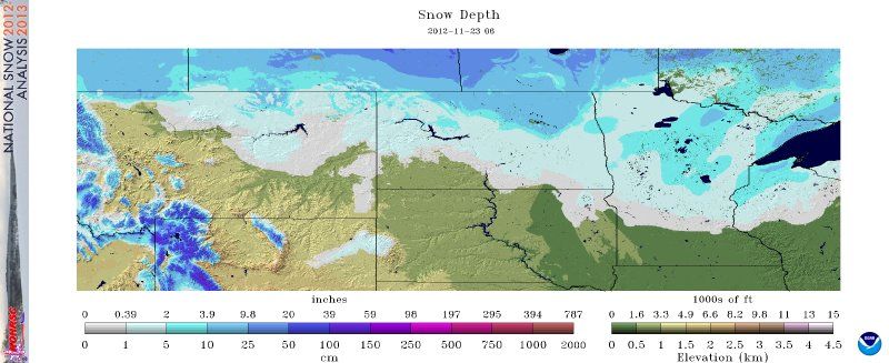
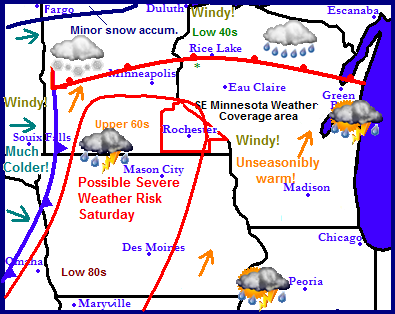
Regional weather view.

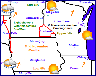
A dynamic weather system will be spreading all sorts of weather acorss the Upper Midwest this weekend. A low pressure system will track from South Dakota to Central Minnesota. South of this feature, a warming trend will be in place bringing unseasonably warm temperatures in the 60s, 70s, and even a few 80s across Iowa. On the west side of this system a sharp cold font will plow into this warm air, which will spark thunderstorms in parts of Southern Minnesota and Iowa, some of these storms could be severe with large hail and damaging winds. Thunderstorms will be numerous in this area. More north north scattered rainshowers are expected north of the warm front, and more north of this area, rain will mix with snow in Northern Minnesota where snowfall accumulations are possible. Strong northeast winds will effect Lake Superior and bring high winds to the Duluth area. Significantly colder air will follow and move into all areas following this front, highs will struggle to get out of the 30s region wide. Drier weather, remaining on the cooler side will be in place the rest of next week.

Photobucket

Local and Metro views.


Photobucket
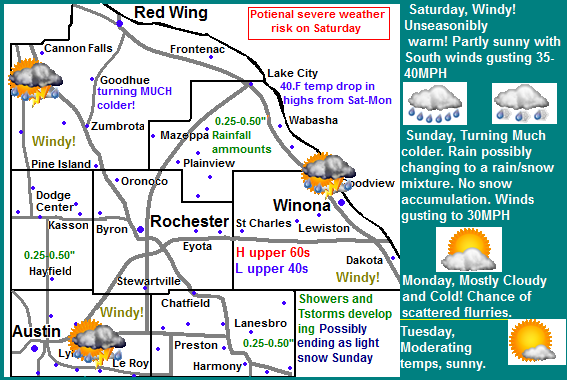
Huge isn't even enough to describe the weather change that is about to happen here in Southeastern Minnesota. Saturday will start off unseasonably mild, we might even have a shot a record highs, Later Saturday a cold front will come in sparking showers and thunderstorms, some of which could become severe. Behind this front it will really start to feel like December for a few days as highs struggle to get out of the 30s. I will break this down into sections.

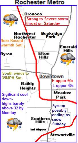
Showers and Thunderstorms break out-Severe weather threat on Saturday

Saturday after morning showers and drizzle, will start off very mild and windy with winds gusting to 35-40MPH Temperatures will rise to near record levels rising to the upper 60s. Some spots may have a shot at 70. Later in the afternoon a very strong cold front will push through the state sparking numerous showers evening numerous showers and thunderstorms to our west, and later push into our are in the evening hours or after dark. Some of these storms may be on the strong to lower end severe side, with hail and high winds will be the main threats.

Rain Sunday possibly ending as light snow-Near 40.F drop in highs from Saturday-Monday

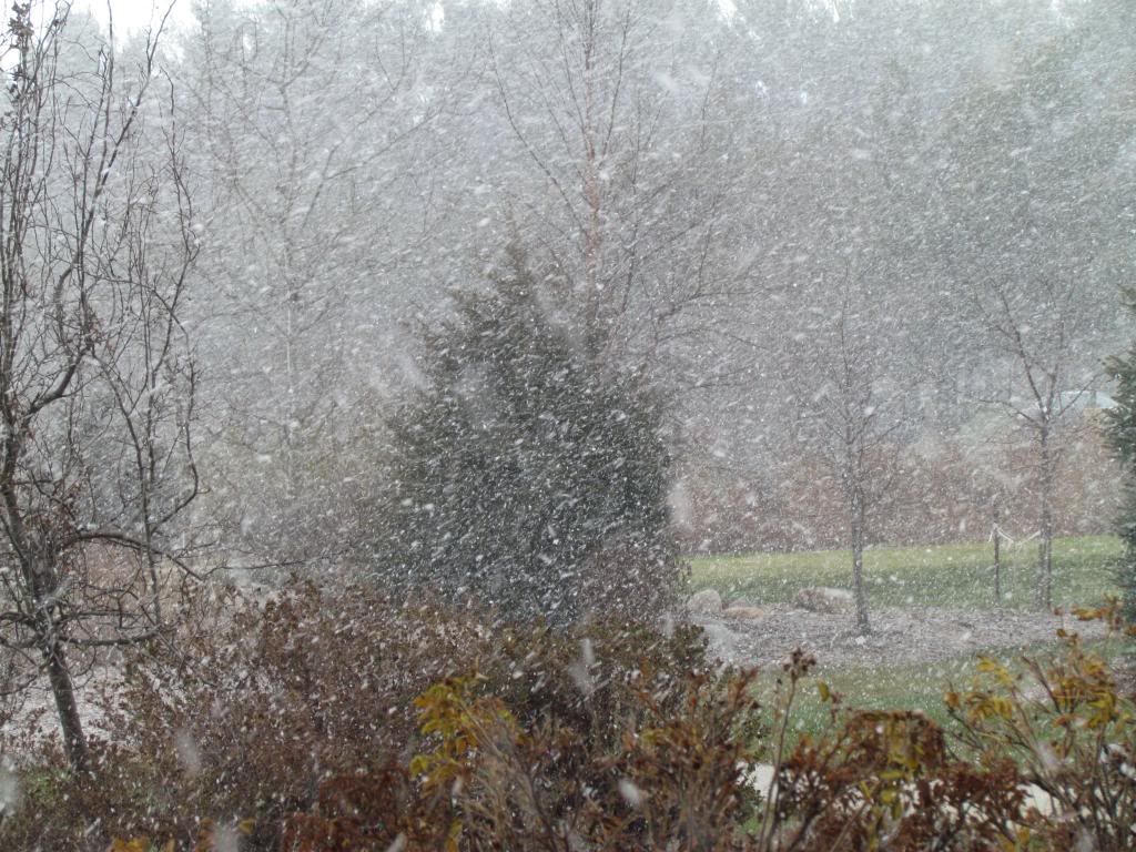
By Sunday the front will have passed leaving significant colder, windy and showery conditions. Temperatures will drop through the afternoon and some of the rain will change to light show or flurries. Little of none of this snow will accumulate. Highs on Sunday will be in the 40s early falling into the 30s by the afternoon, then in the low 20s Sunday Night. Monday is going to feel very cold, with breezy and cold northwest winds. Skies will be mostly cloudy and there could even be some flurries around. Highs will struggle to reach the low 30s for the 1st time this season. Temps will drop Monday Night to their coldest levels of the season so far, approaching the lower 20s and 10s in a few spots.

Saturday, Unseasonably Warm and Windy! south winds gusting 35-40MPH. Showers and Thunderstorms developing in the evening, Some could be strong to severe. Saturday Night, Showers Thunderstorms, some cloud be strong to severe early. lows in the middle 40s.

Sunday, Much Colder and windy! Rain in the morning, possibly ending as light snow or flurries with Northwest winds gusting to 30MPH. Sunday Night, possibly some sprinkles or flurries. Cloudy skies, lows in the low 20s

Monday, Breezy and Cold! Cloudy skies with flurries possible. Cold Northwest winds. Highs in the low to middle 30s. Monday Night, Cold! Clear skies, lows in the upper 10s to lower 20s.

Tuesday, Not as windy, Sunny with moderating temperatures. Highs in the upper 30s, Tuesday Night, Clear skies, lows in the low to mid 20s.

Looking Ahead


Looking towards next week it looks seasonable, cool dry days and chilly dry nights at least through most of Friday. Next Saturday the 17th a weather system arriving from our south will spread a quick shot of rain showers to our area. Clearing out and becoming cooler for Sunday the 18th. Drier and warmer weather prevails for Monday and Tuesday, before a strong storm system starts in Kansas and moves Northeast towards Minnesota. The model then shows widespread heavy rains moving up into our area Wednesday the day before Thanksgiving. The models shows colder air filters in by Thanksgiving day and turns rain to light snows, some of which accumulate even here in Southeastern Minnesota. Very cold air follows this system for the weekend of the 24th, with a chance of flurries every now and then.