Regional Weather View
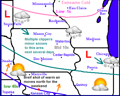
An Arctic Airmass will remain in place over the Upper Midwest for the rest of this week. The entire region will feel the cold airmass with the exception of Kansas and parts of Missouri which will get breaks from the cold with highs in the 40s. The most extreme cold will be across the north. North Dakota, Minnesota and parts of Wisconsin will see several days in a row with highs now getting out of the mid single digits below zero with night time lows around -20.F. Now with a northwest flow over the region, several clipper systems will ride down the back side of the jet stream and will bring several changes for accumulating snows across South Dakota, Minnesota and Wisconsin. Saturday the entire region will get a brief break from the cold as warmer air is pushed into the region. It will be brief as Sunday already more cold air will be pushed back in the north then making its way south next week.
Local Weather View
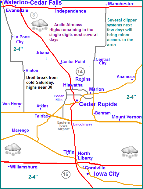
Locally we can expect a cold, very active week ahead of us in terms of weather. An arctic airmass will remain parked over our area for the rest of the week, however it will moderate, and then fluctuate back to colder as the week goes by as clipper systems pass. Highs will generally range from the low single digits to the mid 10s over the next several days and lows will range from as cold as the middle single digits below zero to the lower single digits above zero. Saturday we'll get a break when highs will rise to the upper 20s to near 30. With a northwest flow in place and the back side of the jet stream overhead, this will set the stage for several clipper systems to move through our area, many of the next several days, Monday, Tuesday and Wednesday will feature snows, ranging from light to moderate intensity. Accumulations will range from a trace in one of the systems to a few inches, Several models agree that Wednesday has the best chance over higher accumulations. My map above is a little on the vague side for accumulations, but these will be the general accumulations from all the systems combined. I am being quite a bit on the low side compare to what some models are showing, but there seems to be significant uncertainty in any one system accept for Wednesdays.
Monday, Not as windy, Mostly Cloudy with Light snow developing, minor accumulations. Highs in the upper single digits. Monday night, Snow and flurries, otherwise cloudy skies. lows near zero.
Tuesday, Snow, some could be moderate at times. Highs in the upper single digits to lower 10s. Total accumulations 2-4" Tuesday night, Snow or flurries. Otherwise cloudy with lows in the lower single digits.
New Years Day! Cloudy with a chance of light snow. Highs in the low to mid 10s. Wednesday Night, Flurries and light snow with lows in the single digits above zero. Accumulations 2-4" over the corse of all systems.
Thursday, Partly Sunny skies and cold with highs in the lower 10s and upper single digits. Thursday night, Clear and cold with lows in the lower to middle 10s below zero.
Friday, Sunny and chilly, Light winds with highs in the lower to mid 10s. Friday Night, Increasing clouds with lows in the lower to middle 10s.
Saturday, Much warmer, Cloudy skies with highs in the upper 20s to lower 30s. Saturday night, Cloudy, fog possible with lows in the mid 10s
Sunday, Cloudy with a chance of snow in the afternoon. Turning bluster and much colder late in the day. Highs in the mid 20s. Sunday Night, Blustery, Clear skies with lows in the 10s below zero.
Looking Ahead
The extended forecast does not really look all that great. It shows the arctic front passing through on Sunday this week setting us up for a very cold start to the month. We could be looked at a few days of extreme cold here ourselves in Eastern Iowa, especially Tuesday the 7th. It shows the region bring pretty much dry accept for a chance of a clipper system here or there. Looking towards the 9th of January the models do try and attempt bulid a warm airmass to the west and moving into our area, which will bring warmer temperatures t seasonal normals for a span of possibly several days. Saturday the 11th the models try to develop a storm system over the region, which at this point brings some snow to Eastern Iowa as well as areas of Minnesota and Wisconsin, but the models have troubles determining if this will be significant or not. Like a classic storm very cold air follows behind this storm, with a warmer air, Seasonal temps, coming back into place by Tuesday the 14th. More on this later.


No comments:
Post a Comment