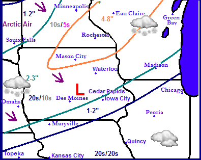
Regional weather view for the upcoming week.
Winter... That is one word to describe the weather for the next few days across the region. Right now the Upper Midwest is in the middle of an arctic airmass number 1. Now a new lower end strength Winter Storm will effect the Upper Midwest bringing widespread snow across a huge area. Much of the states of Nebraska, Iowa, Minnesota, Northwestern Illinois and Wisconsin will be effected with snow by this storm. The low will track across Southeastern Iowa and Missouri which will put the heaviest snow in a swath from North Central Iowa to Southeastern Minnesota to Northwest Wisconsin. Arctic airmass # 2 will arrive behind this for Monday bring 10s and single digits for highs as the weather calms down once again.
For Eastern Iowa we can expect snow to develop late Saturday into the day Sunday. Most of Sunday will likely feature snow showers some of which could be heavy at times, which could cause some commute issues. Temperatures will be in the 20s and winds will be fairly light which will produce a light fluffy type of snow. Accumulations will range across the area but it will be highest the farther north and west you go. Accumulations will be 2-4" over Northwest parts of our area. Waterloo-Cedar Falls, Independence and Manchester can expect to see these amounts. Vinton, Cedar Rapids-Marion, Anamonsa and Monticello will see 2-3" of snow, while the southern parts, Iowa City, Washinton and Mount Pleasant will only see around an 1" or less. There will be a fairly sharp cut off.
The snow will end Sunday night and cold air will pour into Eastern Iowa for Monday when in which we will have arctic sunshine and highs in the lower 10s to possible upper single digits across the far north for highs. Lows Monday Night will fall below zero briefly before we see an increase in temperatures to the 20s for Tuesday, with continued sunshine. Wednesday a weak, but reinforcing shot of cold air will bring lower to middle 10s back into the pictures and it will still be sunny. Its not until Thursday through next weekend that we see a warm up with temperatures rising to the upper 20s and lower 30s, which it more typical for December.
Sunday, Snow, come could be heavy at times. Highs in the lower 20s. Sunday night, Snow in the evening before ending. Total accumulations 2-4" across the North and Central areas. 1" or less for the Southern areas. Lows in the upper single digits.
Monday, Cold! Arctic sunshine with cold wind chills. Highs in the lower 10s to upper single digits. Monday Night, Clear skies, cold with lows in the lower single digits below zero then remaining steady.
Tuesday, Warmer, Sunny skies with highs in the lower 20s. Tuesday night, Mostly Cloudy, flurries possible. Lows in the lower single digits.
Wednesday, Cold with cold wind chills. Highs in the lower to mid 10s. Wednesday night, Cold with lows in the lower single digits.
Thursday-through next Saturday. Warmer, Partly Cloudy with increasing clouds Southerly breezes with temperatures rising to the upper 20s to middle 30s Friday being the warmest day. Lows in the 20s each night.
Looking ahead
Sunday will be colder with temperatures cooling back into the 10s for highs as another show of arctic air. This will bring about dry weather as well. However this airmass is short lived as the forecast models have been persistent at a fairly significant warm up arriving in Mid December around the 15th, however it is still early to decide how significant, but it does show temperatures could rise into the 40s, and possible near 50? for a few days as we approach the 17th of December. A cold front pushes through around the 21st of December bring briefly cooler conditions, however then a another storm system coming front the south brings rains for December 22nd, some of which could be heavy, behind this feature colder air would follow. Overall the 2nd part of December could be warmer then the 1st part has been.


No comments:
Post a Comment