Regional Weather View
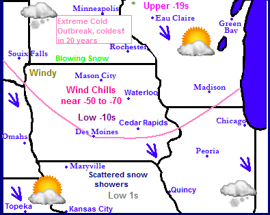
There is only one thing making headlines in the Midwest and that is the extreme cold that is about to ascend onto the region. A bitter cold Arctic Airmass will soon be pledging into the U.S strait from Northern Canada, and a deep snowpack and the extent southward of the arctic high will allow for Very cold to extremely cold temperatures to be seen across all of the Midwest. The core of the coldest extreme air will be seen in all or most of South and North Dakota, Iowa, Minnesota, Illinois and Wisconsin. Temperatures in this area will be the coldest seen in nearly 20 years and have the chance at night will fall into the -20s to -30s be zero range and high temperatures will remain well below zero in this area. Wind chills could be -50 to -70 below zero. This has already lead to the closing of all schools in the State of Minnesota. Elsewhere in the Midwest will also be extremely cold for their respective areas, but generally lower single digits for highs and just above or below zero lows will be seen elsewhere. There will really be not much in the way for precipitation accept for a few scattered arctic flurries. Wednesday warmer temperatures will move into the area putting an end to the extreme cold.
Local Weather View
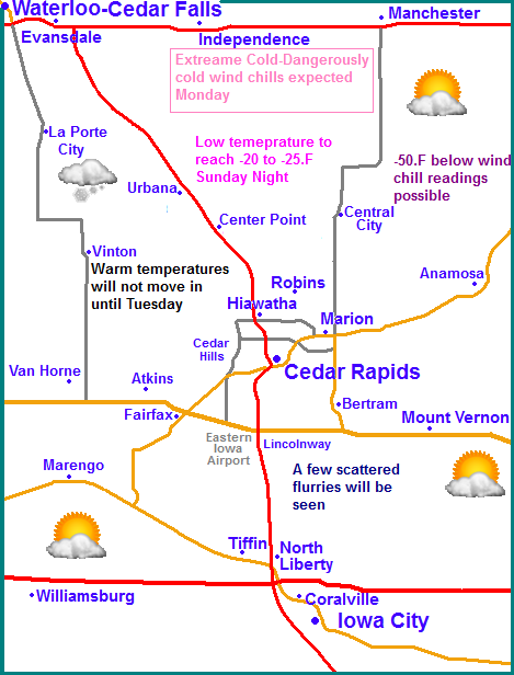
Locally attention will be completely on the extremely cold airmass mentioned above. The arctic front will reach our area tomorrow afternoon as temperatures will drop through the day and will be in the single digits, then eventually below zero. Once we fall below zero Sunday Night it is very likely we will remain below zero until Tuesday and locations towards Waterloo will not rise above zero until Wednesday. The worst of the extreme cold will be Monday Morning and Monday its self. Low temperatures will range from -18.F towards Iowa City to -25. F towards Waterloo, Cedar Rapids will probably be near -20.F. There is a chance some locations of the north could see temps near -30. This level of cold has significance as according to the local NWS it will be the coldest Eastern Iowa has seen since 1996, and in fact it even challenges our 20 year average plant hardiness zones which states that Cedar
Rapids south does not typically see temperatures lower then -20.F This could be a challenge to shrubs and trees on the lower end of the hardiness scale. Monday high temperatures will not rise above -9.F for many Eastern Iowa Citys, and to make things worse winds could gust near 20MPH, which means wind chill values will near -45 to -50.F. It is likely the Watch will need to be upgraded to a Wind Chill Warning. Monday night will not be much of an improvement as lows will still be in the middle to upper 10s below zero. People should take this cold on a more serious level as it does have a life treating nature to it if not taken seriously. Temperatures will finally warm up on Tuesday when Cedar Rapids southward will rise above zero. By Wednesday, all locations should be in the middle to upper 10s as light snow moves in with an approaching warm front. There is hope however...Thursday and Friday temperautres will rise to the upper 20s to near 30.
Saturday, Cold. Strong Northwest winds and low wind chills. Dropping temperatures through the day with highs near 30 early. Saturday night, Blustery with cold will chills Partly cloudy with lows in the single digits below zero
Sunday, Cold! Partly Sunny with Blustery NW Winds and extremely cold wind chills nearing -30.F Highs in the single digits below zero. Sunday Night, Very Cold! Lows in the lower to middle 20s below zero. Wind chills nearing -45.F
Monday, Very Cold! Blustery NW Winds and extremely cold wind chills nearing -45.F or colder at times. Highs in the teens to lower dingle digits below zero. Monday night, Very Cold! Lows in the upper single digits to lower 20s below zero. Wind chills near -45.F or colder
Tuesday, Cold! Not as blustery, Sunny skies with highs on either side of zero. Tuesday Night, Increasing clouds with lows in the middle to upper single digits below zero.
Wednesday, Warmer and cloudy with a chance of light snow. Highs in the mid to upper 10s Wednesday night, A chance of light snow with lows in the low 10s
Thursday, Partly Sunny skies with lows in the low to middle 20s. Thursday night Partly Cloudy with lows in the mid 10s.
Looking Ahead
The long range charts do show good news. Next weekend into the week of the 13th the models have been continuing to hint warmer temperatures finally coming into the area. I don't want to do out too far on the limb, but it does appear we have the chance for several days between the 12th and 14th that could be near 40.F. However, the model shows this warm up is followed by a significant snowstorm on the 15th which brings Eastern Iowa and neighboring Missouri, Minnesota and Wisconsin significance snow. This is of course followed by another arctic airmass. The models show do show it warming back up into the 30s, maybe 40 again towards the end of the run on the 18th and 19th, but that is too far to say we will actually experience that by the time those dates get here. Overall the long range charts show variable weather with snowstorms and cold and warm ups in between. Which is normal for Eastern Iowa.


No comments:
Post a Comment