Regional Weather View
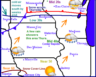
Across the region, a much anticipated warm up for most areas as the jet stream lifts briefly north into Minnesota. This will bring warmth northward with widespread 30s across Minnesota and 30s and 40s across Iowa with a chance of a temperature near 50. In Missouri and Kansas temperatures will warm near 50 and even 60. Thursday a low pressure system will past through Minnesota bringing a chance of a few light rain showers in Iowa with snow in the north. This same storm will also bring colder air back in for the end of the week bring 20s and 30s widespread across the southern part of the area. With the worst of the arctic air staying in Minnesota and Wisconsin where single digits highs are likely.
Local Eastern Iowa View for This week
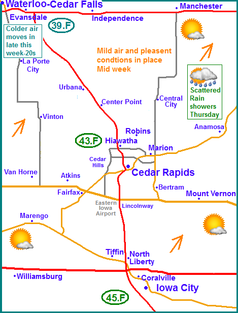
I am introducing a new map that I made for Eastern Iowa. This new map features a close up view of the areas 3 largest Metropolitan areas in East Central Iowa that I cover as well as the surrounding communities. I feel this new map will help better define the area in which I cover. On the map now is the forecast for the upcoming week with the soon to arrive warm up thats heading our way. Monday will signify the start of the warm up with highs warming to the middle 20s. Tuesday and Wednesday is when the warmth will really start to come in as we will have sunshine with highs warming to the middle 30s on Tuesday and the lower to middle 40s for Wednesday and Thursday with the only exception being maybe still an upper 30 degree reading towards Waterloo. Areas near Iowa City and southward towards Washington and Mt. Pleasant may very well approach 50 those 2 days. Scattered light rainshowers and drizzle will spread into Eastern Iowa on Thursday as the cold front nears. There is a chance for some freezing drizzle as the rain starts, but it should not be significant Friday the cold front passes cooling temperatures back down in the 20s for highs, which is will where they will stay through next weekend.
Tuesday, Warmer, Sunny and Windy with highs in the lower to middle 30s. West winds gusting to 30MPH. Tuesday night, Clear skies with breezy west winds. Lows in the middle 10s.
Wednesday, Sunny, Pleasant, not as windy with highs ranging from the upper 30s in the north, to the lower to middle 40s in the south and central part of the area. Wednesday night, Increasing clouds, lows in the upper 20s and lower 30s.
Thursday, Cloudy with a chance of rain, possibly starting off as freezing rain or drizzle then rain. Highs in the upper 30s and lower 40s. Thursday night, Colder with NW breezes Cloudy skies with a chance of rain, possibly becoming freezing rain. Lows in the middle 20s
Friday, Colder with northwest breezes, Sunny skies. Highs in the lower to mid 20s Friday night, Clear skies with lows in the lower teens
Saturday/Sunday, Increasing clouds with a chance of snow. Highs in the lower to mid 20s. Lows ranging from the upper 10s to lower 10s
Monday, Colder and breezy. Sunny skies, highs in the lower 20s. Monday Night, Clear skies with lower in the upper single digits to lower 10s
Looking Ahead
This weekends snow chance: The models are hinting and the potienal for a weekend snowstorm this weekend December 21st and 22nd, but only 1 model shows it hitting Eastern Iowa, and at this point it shows it grazing the area with the worst effects in the Far Southeastern part of Iowa. Most of it looks to miss, however it still needs to be watched for the potential that it could track back towards our area.
Christmas Day at this point looks kinda cloudy but dry with temperatures somewhere around the mid to upper 20s. It shows several small storms missing our area to the north. Friday the 27th looks colder with a chance for some light snows with a clipper system. Saturday and Sunday the 28th-29th a brief warm up for Iowa. We may see the middle 30s especially Sunday before an arctic front pushes cold air quickly back into our area for Monday the 30th and Tuesday the 31st. Heading into the 1st day of January, the model shows a low pressure system tracking over Kentucky bring heavy snows to Eastern Iowa and significantly colder temperatures behind that. But there is still plenty of time for this to change.


No comments:
Post a Comment