Regional Weather view
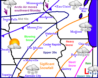
Top story of the regional weather is a storm system that is about to move through the Upper Midwest. This will cause widespread wintery travel impacts including heavy snows in Missouri Southeastern 2/3rds of Iowa, Northwest Illinois and Southern Wisconsin.Cities such as Kansas City, KS Cedar Rapids,IA and Madison,WI will be effected. Sleet, snow and ice will impact Southeast Missouri and the rest of Illinois including Ouincy,IL Peoria,IL and Chicago,IL. A separate storm system will spread light minor snow accumulations into South Dakota, Minnesota and Northern Wisconsin. This will be ahead of arctic front moving down behind the southern Winter Storm. This airmass will bring highs into the single digits with lows well below zero across much of the region. Expect moderating temperatures for Christmas eve/Christmas day with mostly dry weather from the Iowa Boarder South and minor snows across that line north.
Local Weather View
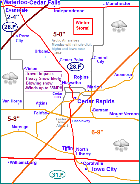
Impacts and accumulations: For Eastern Iowa we can expect that the full brunt of this storm will be hitting our area. A low pressure system will pass through Far Eastern Illinois, this will spread a very intense band of snow through Eastern Iowa. The snow will heavy to very heavy at times possibly reaching 2" per hour totals. Whiteout conditions will be possible at times and these conditions will move in quickly and once they start it will likely last for several hours. Widespread significant snowfall totals will be likely, but the highest amounts will set up roughly southeast of a line from La Porte City to Independence line, effecting the entire 380 corridor area. Expect the highest totals of 6-9" seen across the Southeast including Iowa City and Mount Vernon. slightly less, but still significant amounts of 5-8" will be seen for Williamsburg and the Cedar Rapids Metro area up to Manchester. There will be very sharp cut off in snowfall totals as one heads Northwest. 2-4" are expected across the Waterloo-Cedar Falls area. Travel impacts will be likely with the worst conditions being Sunday morning, with heavy snow lessening by the afternoon. After the initial heavy snow Northwest winds will Gusty winds to 35MPH will cause blowing and drifting snow the rest of the day, but due to the wetter nature of the snow it will not be significant as it could be.Expect the worst drifting to be in open rural areas/fields To make matters worse, Monday the cold air behind this storm will settle into Eastern Iowa and highs will only be in the single digits with lows around -10.F in all areas.
Tuesday through Christmas Day and next weekend:
Tuesday through Christmas we can expect much better conditions. There will be no weather delays in Eastern Iowa and we can expect dry weather with skies ranging from partly sunny to mostly sunny. Temperatures will moderate to the upper 20s on Christmas Day, but this warm up will be brief as a secondary shot of reinforcing show of arctic air will arrive for Thursday after Christmas. Some light snow or flurries action could be seen with this front but amounts will be very light and not cause issues. Highs and Lows Thursday and Friday will be back into the 10s for highs and the middle single digits below zero for lows. Saturday there could be some light snows again but amounts look again light and Sunday will be warmer, near 30 with partly sunny skies.
Saturday, Cloudy skies with snow developing late. Highs in the upper 20s. Saturday night, Snow, snow will be heavy at times. Turning increasingly windy with blowing snow possible. Winds gusting to 30MPH Lows in the low 20s.
Sunday, Snow, Snow will be heavy at times in the morning before tapering in the afternoon. White out conditions in the morning Windy with blowing and drifting snow. Winds gusting to 35MPH at times. Storm total accumulations 5-9" across the South and Central and 2-4" across the north. Highs in the lower 20s Sunday night, Lingering light snow with slacking winds. Lows on either side of zero.
Monday, Cold! Sunny skies, Blustery northwest winds with low wind chills. Lows in the middle single digits. Monday night, Cold! Clear skies with lows in the upper single digits below zero to the lower teens below zero.
Tuesday, Sunny skies, not as windy and not as cold. Highs in the mid 10s. Tuesday Night, increasing clouds with lows in the lower 10s.
Christmas Day Much warmer, Partly Sunny skies with highs in the middle to upper 20s. Wednesday night, Cloudy skies with a chance of light flurries or snow. minor light accumulations. lows in the single digits.
Thursday, Partly Sunny with a chance of flurries, otherwise just cloudy skies. Highs in the middle 10s. Thursday night. Cloudy with lows in the middle single digits below zero.
Friday, Partly Cloudy skies, light winds with highs in the upper 10s. Friday night, lows in the single digits.
Weekend: Looks dry with cooler temperatures in the 20s on Saturday and highs right around 32 on Sunday. lows will be in the 10s.
Looking Ahead
The end of December into the 1st part of January look cold with clear skies with maybe a few clipper systems moving through Eastern Iowa with the majority of them to the north. Then towards the very end of the model run we see a storm system trying to take shape around Monday the 6th. This system looks to effect a very large portion of the midwest, but this is still a long ways out. The jet stream does try to take on a warmer look for us possible sometime after the 6th, but we will know more once the model gets past that date.


No comments:
Post a Comment