Regional Weather View.
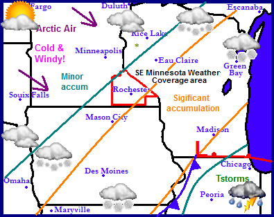
It is turning out to be an active week in the Upper Midwest. Something I have not had to say in a long time. Attention is turned to our next weather producer which will spread thunderstorms across Illinois tonight, and significant snow accumulations to parts of Iowa, Far southeast Minnesota and parts of Wisconsin. A cold arctic airmass is waiting to move in behind this storm on strong northwest winds. The entire region will be plunged into this aissmass as the low moves away. The cool airmass will also keep things fairly dry. Temperatures will begin to moderate though the weekend.
Local and Metro views.
 Winter storm for eastern parts of the area.
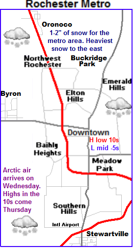
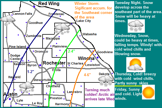
Parts of our area will be dealing with a winter storm, but because of the way this storm is shaped only the eastern parts will have this take place. Late tonight as a low pressure system moves from Missouri to Illinois snow will spread northeast through Iowa and into Southeastern Minnesota. A cold front will also sweep in from the northwest. The far western extend of the system will effect our area. Eastern Fillmore and Winona counties will see the heaviest and brunt of the accumulating snows Winona, Harmony, Lanesbro are just a few of the coummunties which stand the best chance at seeing winter storm value accumulations. There will be a sharp cut off, Further west 2-4" are possible including Preston, St Charles and Wabasha. West of here 1-2" are possible effecting Rochester, Austin and Lake City. North and west of here will just see flurries. Blowing snow and free falling temperatures will be a problem as winds gusting up to 40MPH at times bring in an arctic airmass from the northwest. Temperatures will fall into the single digits late Wednesday and below zero Wednesday Night.
Brunt of arctic airmass in place by Thursday.
For Thursday the brunt of the arctic airmass will be in place. It will also be breezy with cold wind chills making it feel colder. Highs will be only in the single digits above zero, with lows possibly falling to their coldest levels of the season so far with a fresh snowcover lows may fall to the 10s below zero. Friday will be sunny and cold but slighlty warmer then Thursday. It will also not be as breezy. Highs will be in the upper single digits, with lows in the single digits above zero as clouds increase Friday night. Saturday and Sunday temperatures will moderate to the 20s and 30s with lows in the 10s. There is a small chance for light snows on Saturday but the chance is low at this time.
Wednesday, Snow likely, heavy at times east. Much Colder! and Windy with winds gusting to 40MPH. Snow accumulations 1-4" Central areas with 4-6" in the East part of the area. Wednesday Night, Cold, Windy with cold wind chills. Lows in the mid single digits below zero. Winds gusting to 30MPH
Thursday, Cold! Breezy with cold wind chills, Arctic Sunshine, highs in the low to mid single digits. Thursday Night, Cold! Clear skies, lows in the low to mid single digits below zero.
Friday, Cold! Sunny skies with highs in the mid to upper single digits above zero. Friday Night, Increasing Clouds and a chance of flurries, Chilly with lows in the single digits.
Saturday, Partly Sunny and warmer. A chance for flurries. Highs in the mid 20s. Saturday Night Cloudy, lows in the mid to upper 10s.
Sunday, Pleasant, Sunny, light winds. Highs in the low to mid 30s. Sunday Night, Partly Cloudy, lows in the upper 10s to lower 20s.
Looking Ahead
Monday a weak clipper system passes to the north, not bringing us any additional snow. Tuesday a mild dry airmass moves in bringing pleasant to warm temperatures and dry conditions through Thursday. There is a chance we may see 40s for highs some days. Friday the 8th a cold front passes through dry and brings in cold air for the weekend of the Sunday the 10th of February. Slightly milder air arrives for the start of the week of the 12th. Then things turn more active once again. Tuesday the 13th of February a low pressure system moves form Kansas to Illinois bringing us a snowstorm here in Minnesota and very cold and drier air after the passing of this storm. More as on this later.


No comments:
Post a Comment