
Iowa Weather Network Warnings Map

Winter Weather Advisory
Sunday, January 20, 2013
Arctic airmass made its presence known across Southeast Minnesota with powerful 50-60MPH wind gusts and a 25-30 degree temperature dr
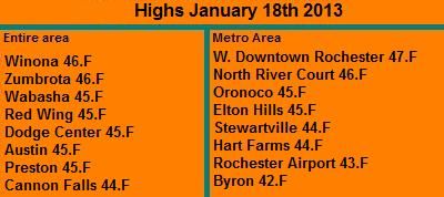
Warm January day, January 18th 2013
This weekend was definitely had two totally different tales to tell. Friday and Saturday was sunny and mild. Fridays highs were in the mid to upper 40s and Saturdays highs were in the lower 40s. The sun was shining, the sky was bright, winds were light and it felt like the feel of spring in the air. This was the calm before the arctic airmass blew through the area.
Highs Friday January 18th
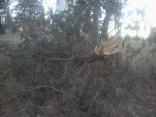
Large tree branch down St Marys Park
Arctic Cold Front
As beautiful as it was everyone knew a strong arctic cold front was about to plow through the area, and it definitely made its presence s known. After a high of 43.F here at my station Saturday early afternoon, winds switched northwest abruptly ending out feed of warm air from the south. The winds turned very strong and just downright powerful through the late afternoon hours into the evening hours gusting 50 to 60MPH. A very impressive wind gust of 66MPH was recorded at the Downtown Rochester weather station, but this number may have been increased by the fact that this weather station is 8 stories off the ground, but even the Rochester Airport recorded a wind gust of 55MPH, and every station throughout the area reported widespread 44 to 55MPH gusts. The wind was definitely the major player with this front, it was usually strong and caused havoc blowing things around, and even causing some minor tree damage to mostly evergreens. Many residents felt the winds. There were quite a few things to pick up the next day. The worst of the winds lasted about 5 hours. The other thing the winds did was draw in very cold air from the northwest. By 5pm temperatures had cooled down to the middle teens and it felt like quite a shock. By morning Sunday temperatures were 25 to 35 degrees colder then they were on Saturday, as seen below. What was odd about this arctic airmass is it did not come with any snow, so even though its cold out now, we still have no snow on the ground, which I have to say is quite an odd look with an arctic airmass in place.
Reported Wind Gusts + Highs Saturday / Lows Sunday Morning
West Downtown Rochester 66MPH 43.F / 3.F
Rochester Airport 55MPH 41.F / 1.F
Dodge Center 53MPH 41.F / 1.F
Preston 52MPH 42.F / 1.F
Cannon Falls 51MPH 41.F / 2.F
Winona 46MPH 43.F / 5.F
Austin 45MPH 43.F / -0.F
Red Wing 44MPH 41.F /1.F
Subscribe to:
Post Comments (Atom)


No comments:
Post a Comment