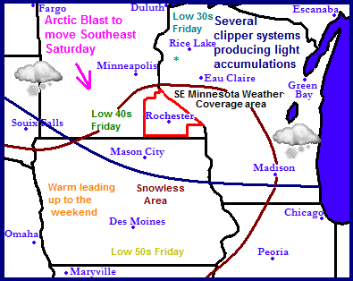
The region is in a change of weather patterns this week ahead of a major arctic blast poised to move southeast later this week. Ahead of this airmass, mild weather will be seen. especially in new snow less areas that developed from last week. With a jet stream located near us and with a northwest flow in place several small clipper systems over the course of of next week. A significant cold arctic outbreak will arrive early next week sending very cold temperatures and a chance for clippers continuing to our northeast.
Regional Weather View.
 Clipper Wednesday
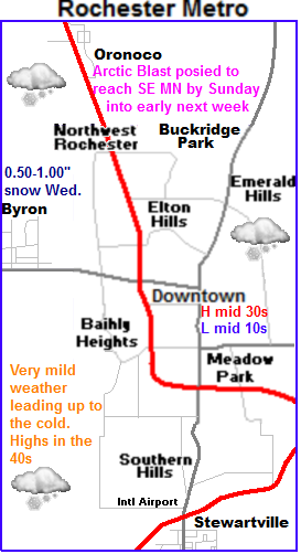
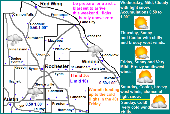
For us this week we can expect warmth through the rest of this week. Some days will even be on the quite warm side. Wednesday ( tomorrow) is our next shot of snow, it will be light in nature and will be done by Wednesday Evening. and accumulations will be light in nature generally around a half inch. Possibly 1 inch being on the very generous side. Thursday will be sunny and cooler with highs in the 20s behind this system, wind chills will be quite cold with breezy west winds. Lows will fall into the mid 10s
Warmth on Friday
Friday as a clipper system passes to the Northeast warm air will be sent back in to Minnesota and enhanced by the fact that we have no snowcover. With breezy southwest winds in places, highs will reach the middle 40s with the potential for higher temps in the upper 40s depending on how far north the clipper goes.
Big cooldown by the weekend. Significant arctic air in place by Sunday
I wanted to spend the majority of the time in this forecast on the cold air which has been bottled up in Canada for the last month that is about to make a huge advancement southward starting late Saturday as a cold front sweeps through. Highs Saturday will start in the upper 30s as mile air will still be in place but they will drop from there, and wind chills will make it feel colder as strong winds gust from the west over 40MPH at times. There will be slight chance of snow on Saturday with the arrival of the air but accumulations look very low, little to none. It is actually looking like we may enter the arctic blast with little to no snowcover on the ground, which will in turn mean moderated temperatures from what they could be, but at the same time it is unfortunate that we may not have the proper protection for landscapes that snowcover provides. Sunday and especially Monday the full brunt of the arctic air will be in place. Highs on Sunday will be in the upper single digits, with lows falling into the middle to upper single digits below zero. Monday will be cold, the coldest we've seen for highs in some time. Highs are expected to be only in the middle single digits, with lows falling to the double digits below zero in places. The cold air will stay in place at least the 1st half of next week, any moderate by Thursday. This arctic outbreak will be enhanced by the fact that we had a very warm winter last year. People should spend the ample time preparing for the cold weather that is expected.
Thursday, Sunny and cooler. Breezy west winds with chilly winds chills. Highs in the middle 20s. Thursday Night, Increasing clouds with lows in the upper 10s.
Friday, Windy, Significantly warmer. Sunny with winds gusting to 35MPH Highs in the lower to mid 40s Friday Night, increasing clouds with lows in the upper 20s.
Saturday, Windy and colder, A chance of flurries, then clearing skies. Winds 35MPH gusting to 45MPH Highs in the upper 20s before dropping. Saturday Night, breezy with cold wind chills. Lows in the lower single digits to lower single digits below zero.
Sunday, Cold with very cold wind chills. Breezy. Partly Sunny with a chance for flurries. with highs in the upper single digits. Sunday Night, Clear skies, lows in the mid single digits below zero.
Looking Ahead
Looking towards next week be prepare for the peak of the arctic blast arriving will occur on Monday and Tuesday of next week. It will be sunny, but highs will only be in the single digits and lows will be in the 10s below zero range. The coldest we've seen in at least a year. Wednesday the 15th looks like the next chance of snow for us, a small clipper may deliver some light snow to our area but it looks light. Friday the 25th next week a bigger more potent clipper system moves southeast from North Dakota and delivers snow to much of the state, but the heaviest looks to be just north of our area at this time. Temperatures are warming up slightly during this time. By Saturday and Sunday the 26th/27th a brief warmup arrives and it appears dry. We continue to develop towards a drier warmer pattern as the end of the month approaches. The jet stream is keeping most of the snowfall to our north, but changes will occur to this as the month goes on.


No comments:
Post a Comment