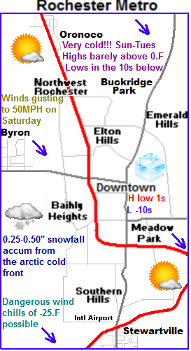
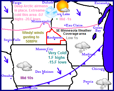
Very cold temperatures are making their way southeastward today as an arctic cold front blows through the region as causes some issues. The arrival of this cold air will cause problems mainly in the form of strong gusty wind gusts to 50MPH across a wide part of the region. This front will have limited moisture so Very little snowfall will be seen with this as it passes through But existing snowcover on the ground will blow around in areas across Central and Northern Minnesota, causing problems with blowing snow. Extremely cold temperatures will pour in behind this front. In North Dakota, Northern Minnesota and Wisconsin highs will be below zero. With lows falling in the pink shaded area in the 20s below zero range. It will not be much warmer across the rest of the area highs will range from the lower single digits in Southern Minnesota to the middle 10s in Southern Iowa. Temperatures will moderate starting Wednesday.
Local and Metro views
Note: This forecast is an update to the previous one.
 Passing of an arctic cold front will lead to light snow and 50MPH winds today
A very strong cold front will sweep across the region today and usher in significantly colder temperatures which will feel very cold to many due to the warmth we've been experiencing lately. Highs will peak out in the lower 40s early in the day Saturday, then by the afternoon the arctic front will be on our doorstep, a quick burst of snow will push through with a quick accumulation of a Trace to a 0.50" Winds will pick up drastically and become a problem with Winds will turn northwest and become strong 35MPH gusting to 50MPH at times Which is likely to cause some problems and possibly even some blowing snow, but will be highly dependent on how much we receive with the front. The winds will continue at this strength through the evening ushering in significant colder temperatures.
Arctic Airmass in place Sunday-Tuesday Very cold temperatures, dangerous wind chills
Sunday will be significantly colder then Saturday by as much as 35 degrees colder. Which is why I have blue ice cubes on the maps to represent how we all may feel by the time Sunday comes around! Temperatures during this outbreak will be slightly moderated by the fact we have no snowcover. We can expect highs in the single digits but breezy northwest winds to 30MPH will make if feel much colder as wind chills will be lowered to dangerous 20 -25.F levels. Early Sunday will have a chance of some wind driven light snow. Accumulations will be light. Sunday Night will be mostly cloudy and cold, with lows in the lower 10s below zero. Wind chills will be just as dangerous as they will during the day. Monday will be the coldest day. It will be very cold under arctic sunshine and breezy northwest winds bringing about very cold wind chills, Highs will only be in the lower single digits, and some areas may not in fact get above zero! and lows Monday Night will be in the mid to upper 10s below zero It is important to note these will be the coldest temperatures our area has seen in a least 2 years, and it will be complicated by the fact that wind chills will be in the -20 below zero range, so be prepared. Tuesday will not be much warmer, but at least winds will slacken, highs will be in the lower single digits above zero, with arctic sunshine. Lows will be in the mid single digit below zero.
Slightly warming temperatures by Wednesday
Wednesday it finally begins to warm up to tolerable levels, With increasing clouds reveling a cloudy Wednesday, highs will rise to the lower 10s and lows will fall to the single digits above zero. The areas next chance of snow will be Thursday.
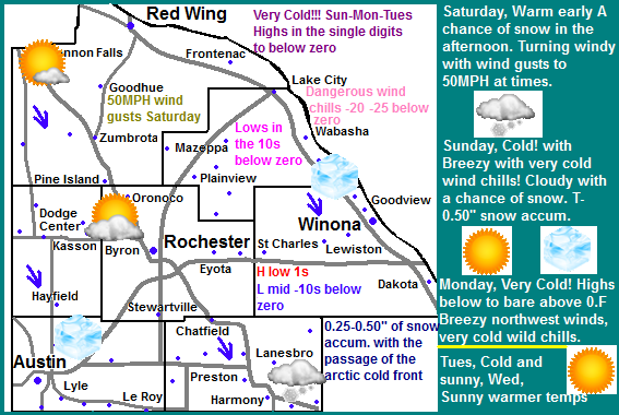
Saturday, Mild, Partly sunny with highs in the lower 40s. Increasing clouds in the afternoon with a chance of snow. Accumulations Trace to half inch, Winds turning northwest and increasing to 35MPH with gusts to 50MPH. Saturday Night, Turning Cold, with dangerous wind chills, Windy, winds 35MPH gusting to 50MPH
Sunday, Cold! and breezy with dangerous wind chills around -20.F Mostly cloudy with a chance of light snow, accumulations Trace to a quarter inch. Highs in the lower single digits. Sunday Night, Very Cold! Clearing skies with lows in the lower to middle 10s below zero.
Monday, Very Cold!!! Arctic sunshine with breezy northwest winds and cold wind chills. Highs in the single digits above, to single digits below zero. Wind chills -10 to -15.F below. Monday Night, Very Cold!!! Lows in the mid to upper single digits below zero.
Tuesday, Cold! Arctic Sunshine with increasing clouds. Highs in the lower single digits. Tuesday Night, Mostly cloudy with lows in the mid to lower single digits below zero.
Wednesday, Warmer, Partly sunny with highs in the mid to upper 10s. Wednesday Night, Mostly Cloudy with lows in the mid to upper single digits above zero.
Looking Ahead
Thursday is our next chance of snow as an organizing system may bring us some snowfall, but it really doesn't look heavy just yet, maybe a couple inches at most. Cold air surges in behind this and gives us another breif shot of arctic air. Next weekend it warms but looks dry with more seasonable temperatures, with clouds and some sunshine. Monday the 28th a nice warm up moves in from the west bringing mild temperatures into the 30s. Tuesday the 29th a large system develops to our south over Oklahoma and brings a snowstorm to areas of the Midwest. The model does keep it to the east of our area with only the far western edge effecting us, but it will be one to watch and see if it stays in the model. After the passing of this storm it turns cold and drier once as we start out the month of February.


No comments:
Post a Comment