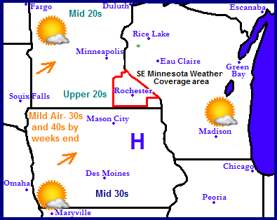
A very dry pattern has set up across the Upper Midwest. A split level flow has allowed for all the storm systems to remain north and south of the region, bringing dry weather with seasonable temperatures. Early next week southwesterly winds will spread continued sunshine and warmth to the region with high temperatures reaching the lower 30s to as high as the mid 40s across southern Missouri and Iowa. The regions next change of precip will be Thursday of next week when a storm system will move across the central U.S bringing rain and snow to the area.
Local and Metro views.
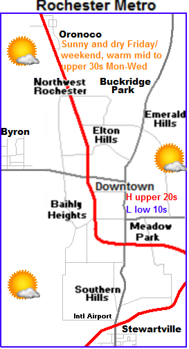
 This week through this weekend into the 1st part of next week will be very quiet for the area. It will be a weather pattern which will bring multiple days of weather which will be a near repeat of its self. We can expect Friday through Sunday to feather calm dry and sunny weather which highs ranging from the middle to upper 20s, and lows in the upper single digits to lower 10s. Monday, Tuesday and Wednesday will bring in even milder weather as winds turn southwesterly. Highs will be in the lower to middle 30s each day with lows warming to the mid 10s to lower 20s. Next chance of precipitation in the form of rain will be Thursday.
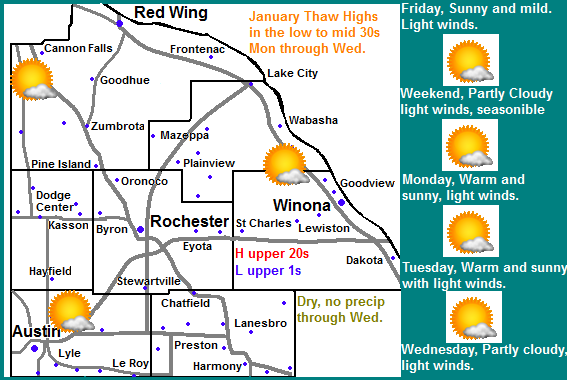
Friday, Sunny skies, seasonable. Highs in the upper 20s, light winds.Friday Night, Clear skies, lows in the upper single digits to lower 10s
Saturday, Partly Cloudy skies, seasonable. Highs in the middle 20s, Light winds. Saturday Night, Partly Cloudy, lows in the upper 10s
Sunday, Sunny skies, seasonable. Highs in the middle 20s. Sunday Night, Clear skies, low to mid 10s.
Monday, Mild! Sunny skies, Breezy southwest winds. Highs in the low to mid 30s. Monday Night, Clear skies, lows in the mid 10s
Tuesday, Mild! Partly Cloudy Skies,, breezy southwest winds. Highs in the low to mid 30s. Tuesday Night, Clear skies, lows in the upper 10s to low 20s.
Wednesday, Warm, Cloudy Skies, breezy southwest winds. Highs in the mid to upper 30s. Wednesday Night, Increasing clouds. Lows in the middle 20s
Looking Ahead-Thursday the 10th is the next shot of precip in the form of rain
Most of this month could take on a fairly active note after this quiet weather pattern. next chance of precip in the form of rain will be from a quick moving storm system moving up through the central U.S on Thursday January 11th. Another quick moving, and stronger storm will be right on its heels and could accumulating snow to our area and wind Saturday and Sunday January 12th and 13th. Most of the accumulating snow looks to be across most of Minnesota with this potential storm. Significantly colder air rushes in southward behind this storm introducing a cool moist northwest flow pattern which could send in a few minor clipper systems. One on the 15th and another on the 16th.


No comments:
Post a Comment