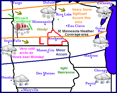
It is more then apparent now the big talk in weather for the weekend is a developing Winter Storm forecasted to impact northern parts of the Upper Midwest. A low pressure system will slide through Nebraska, then northeast through Iowa and Wisconsin. This set up will has the potential to bring heavy snows with significant snowfall to Central and Northern Minnesota and Northwestern Wisconsin. With minor accumulations immediately south of this area. Northwest winds will develop behind this storm system which will kick up blowing snow across much of Minnesota and Wisconsin. The strongest shot of Arctic air so far this season will proceed this storm on Monday. Tuesday into much of next week we can expect a slow warming trend with cloudy skies prevailing much of the week.

Local and Metro views.
 Winter Storm Shifting south increasing totals across the area, minor to significant accumulations possible!
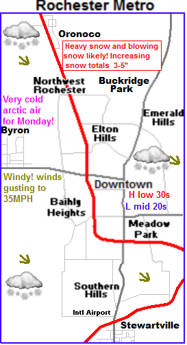
Saturday, the mentioned storm system will be working its way into our area. Expect most of Saturday to be cloudy with highs in the mid to upper 30s. Snow will start Saturday Night with lows in the upper 20s, Current forecasts are trending this storm farther south, bringing the heaviest accumulating in this storm of snows in the range of 8 to possibly even 10" range over the Twin Cities area. While we here in Southeastern Minnesota will be on the more southern side of this system, meaning accumulations will be in the 2-5" inch range give or take. Still I don't want this system under played for Southeastern Minnesota because of several reasons, its the 1st bigger snow system we have seen in nearly a year due to last years snow drought, and second, heavy snow is likely, and travel impacts will be quite high, and especially heightened due to the 1st real accumulating snow of the season. Sunday is when the heaviest snow will fall, we can expect temperatures in the low 30s during this snowfall. Sunday Night and Monday will be very cold, as a brief arctic airmass flows southeast. highs, Lows Sunday night will approach the lower single digits, and with wind chills, it will feel well below zero at times. Highs Monday will only be in the low to mid 10s with our fresh new snowpack Tuesday through most of next week looks dry, but lots of clouds will stick around with temperatures slowing rising through the week.
Accumulations and timing Breakdown.
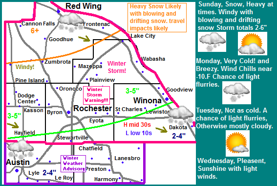
Current model data has shifted the storm slightly south bringing the change of significant snowfall into north parts of our area Accumulations still look to be highest in northern part of the area, Cannon Falls and Red Wing areas look to receive 6 or more inches. Which makes it a low end winter storm. Central Area accumulations have been increased to 3-5" this would include areas around The Rochester Metro Area, Dodge Center, and Lake City. Southern areas look now to recive 2-4" of snow, areas in this category include Austin, Winona and Preston. The timing for this snow will start late Saturday after dark. The snow will start off light but overnight Saturday into early Sunday, moderate to brief Heavy snow will envelop the area. To make conditions worse Northwest winds 25-35MPH will kick up blowing and drifting snow Sunday afternoon. The worst travel times will be late Saturday into early Sunday before 1pm. After 1pm conditions will improve, but it will still be windy blowing and drifting snow. Very cold conditions will develop Sunday Night into Monday with wind chills possibly dropping into the -10.F or colder range, with actual temperatures in the lower single digits Sunday Night rising only to the lower to mid 10s Monday, People in Southeastern Minnesota should take time to prepare for our 1st significant storm system of the winter season and remember winter driving skills and to dress for cold weather. It has been awhile since these conditions have effected the area.
Saturday Night, Snow developing late, could become heavy at times. Lows in the upper 20s.
Sunday, Snow, Windy with blowing and drifting snow. Snow will be heavy at times early. Strong Northwest winds developing gusting 25 to 35MPH, System total accumulations 2-4" south, 3-5" central, 6+ inches north. Highs in the lower 30s. Sunday Night, Very Cold! Lows falling to the mid to upper single digits. Very cold wind chills well below zero. Winds could gust to 30MPH
Monday, Very Cold! Breezy with wind chills below zero, Partly Sunny with a chance of wind driven flurries, Highs in the lower to mid 10s Monday Night, Increasing clouds, lows in the upper single digits to lower 10s.
Tuesday, Mostly Cloudy skies, with a slight chance of flurries, Warmer with highs in the middle 20s. Tuesday Night, Cloudy skies, lows in the upper 10s to lower 20s.
Wednesday, Mostly Sunny, warmer Highs in the lower 30s. Wednesday Night, lows in the middle 20s.
Looking Ahead
Weather for the rest of the work week looks quiet and dry with fairly seasonably temperatures. The next storm system will possibly come in this weekend. Beyond this and it will not be updated at this time due to the upcoming weather event.


No comments:
Post a Comment