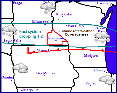
Tonight and Tuesday: A small fast moving system currently located in South Dakota will quickly move east following the I-90 corridor across the southern part of Minnesota. This small feature will spread a quick burst of snow for Southern Minnesota and Central Wisconsin for late tonight into the 1st half of tomorrow, especially near the morning commute. Accumulations with this event will be 1-2" across our entire area with the chance to be on ether side of those amounts wither it be less or more. It could be briefly heavy at times with totals adding up fairly quick. It will be a wet type of snow as temperatures will rise into the middle 30s under cloudy skies for the rest of Tuesday. Roads should not be too slippery once temperatures warm up. The snow should be completely done by 2pm. Tuesday Night will be cloudy with lows in the 20s Wednesday will be cloudy with snow developing after 5pm from our next system which is still in question on amounts and timing this will lead to possibly accumulating snow Wednesday Night into Thursday. See more below.

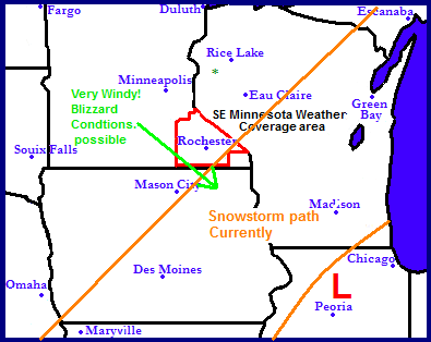
Likely low pressure track for Thursday.
Wednesday night and Thursdays storm are still highly dependent on the low pressures track, but it will likely just graze our area, with the most severe impacts being to our east. There are two possible tracks of this storm. One track that the models have been favoring them most lately would be that the low would track closer to Peoria,Illinois. This would keep all significant snowfall accumulations south of our area. However the other track shows the storm passing near Des Monies, Iowa. This track favors our area to see significant snowfall accumulations along with very windy conditions in which could create blizzard conditions. What is un convincing to me as a forecaster is that there is still some disagreement but it is becoming more apparent that the track will likely be the one above. Please stay tuned to your favorite weather sources concerning this significant winter storm.
Accumulation potential how it looks now.
Accumulations for this system as it looks tonight look to be 1-2" for locations Northwest of a line from Lake City to Byron to Austin. Including such areas as Dodge Center, Mantorville, Kenyon, Pine Island, Cannon Falls and Red Wing for locations 2-4" Northwest of a line from Le Roy to St Charles to Wabasha, including The Rochester Metro, Plainview and Adams, and 4-6" southeast of this same line effecting Winona and Preston areas.
Big cooldown expected after the storm
No matter what amounts accumulate during this event is is extreamlly apparent that temperatures will drastically cool down as cold air is drug down from the north behind the storm. Highs Thursday through the weekend up until Monday of the upcoming week of Christmas will only be in the 10s and lower 20s with lows dipping into the single digits at night. So be prepared for a big cool down after the middle of the week.


No comments:
Post a Comment