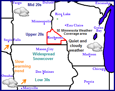
The weather is quieting down after yet another snowstorm impacted the southern part of the Midwest. Thius snowstorm re established a thick snowcover that covers the entire region from north to south, a rare observance for this late into winter. The weather for the region will start off rather cloudy with gradual clearing skies across the region. There will be no additional rain or snow through Sunday. This Monday is the next chance for snow, see the looking ahead forecast.
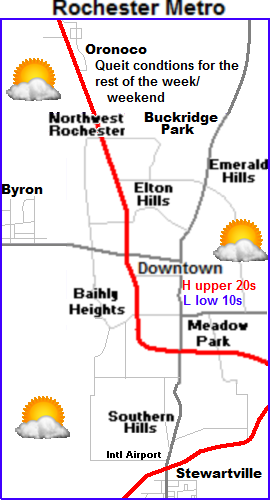
Local and Metro views.
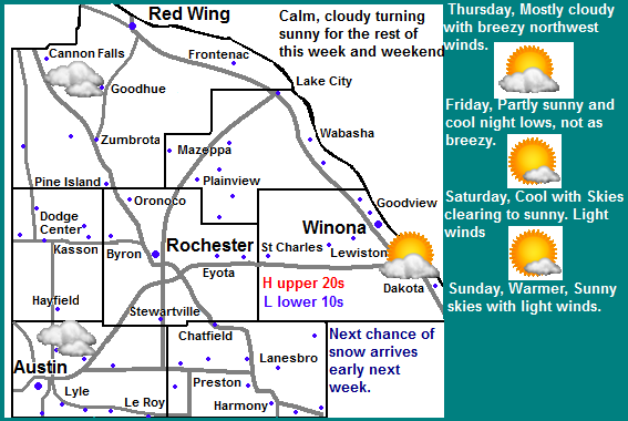
 This will end up being a fairly quick forecast because it looks fairly quiet in the short term. A bit of light snow from a passing large snowstorm to our south on Wednesday will leave behind cloudy and cooler conditions for Thursday and Friday. Besides being cloudy and Blustery with winds gusting to 20MPH we can expect highs in the upper 20s with lows cooling to the low to mid 10s both days and night. Skies will begin to clear on Friday. Saturday and Sunday will be the nicer days of the ones to come. Cloudy skies will give way to sunny skies with highs in the upper 20s and lower 30s and lows in the low to middle 10s. The next chance of snow for the area is Monday as described below.
Thursday, Cloudy and cool with blustery north winds to 20MPH at times. Highs in the upper 20s. Thursday Night, Cloudy and blustery with lows in the mid 10s.
Friday, Mostly cloudy and cool with gradual clearing. Blustery north winds gusting to 20MPH at times. Highs in the upper 20s. Friday Night, cool, clear skies, lows in the low to mid 10s.
Saturday, Sunny skies, not as windy and warmer. Highs in the upper 20s to lower 30s. Saturday Night, Clear skies, lows in the upper single digits to lower 10s
Sunday, Sunny skies, light winds highs in the upper 20s and lower 30s. Sunday Night, Increasing clouds lows in the mid to upper 10s.
Looking Ahead-Next chance of snow on Monday
Both the GFS and European models are coming together on a strong clipper system moving through the Midwest on Monday. At this time, the European model shows the projected path of the storm to start from North Dakota moving on a Southeasterly track directly through Southern Minnesota. This track would favor our area for some of the heaviest amounts. The most snow looks to fall Monday before clearing on Tuesday. We'll have to see now this storm/system progresses over the next few days to make estimates at accumulations. The European model shows After next Tuesday weather conditions begin to turn sunny quiet and pleasant. It snows a spring like warm up for the middle part of next week with temperatures possibly approaching 40 degrees a few days, especially towards weeks end. It also shows a chance of rain developing Friday March 8th with the next storm system to arrive to our region. However is should be noted all models do show a warming tend next week, but the models show disagreement on the extend of the warm up especially for system at the March 8th time frame. Level of trust in the models is quite low at this time.


No comments:
Post a Comment