Regional Weather View
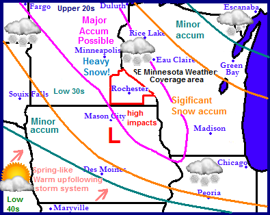
Another major snowstorm is targeting the Upper Midwest only this time is has it's highest impacts set to take place in parts of North Dakota, South Dakota, Northern Iowa, Minnesota and Western Wisconsin. A strong low pressure system will race Southeastward from North Dakota and take a rather interesting path which will spread long duration snow over the central part of the Upper Midwest. After the low races Southeastward, it will stall out over Iowa on Monday Night and then gain strength before moving eastward towards Illinois. This will spread 2 waves of heavy snow which will result in major accumulations in the pink corridor highlighted above. The storm will completely clear the region by Wednesday and a high pressure system will move in spreading sunshine and spring like warmth into the region by Thursday and lasting through the weekend.
Local weather view and metro weather view.
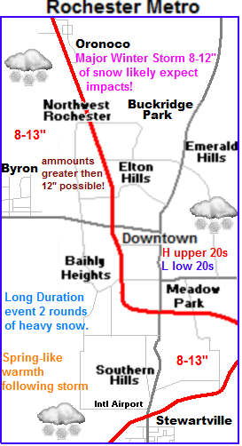
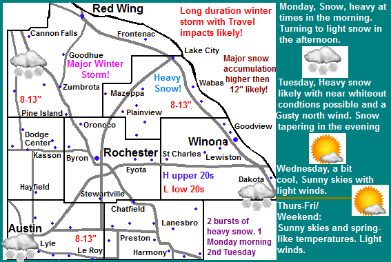
 The Major Winter Storm will impact Southeastern Minnesota with very heavy snow and high snowfall accumulations. There will be 2 rounds of heavy snow for the area. One early Monday as the low moves Southeast and then there will be a temporary lightening or end to the precipitation on Monday Afternoon, before it re starts up again as the low starts to strengthen and move east Monday Night. More bands of heavy snow will push into the area lasting most of Tuesday. The heaviest snow and highest accumulations will take place early Tuesday. Winds during this event will be minor compared to past storms with gusts up to 20MPH possible. Temperatures will be in the upper 20s to lower 30s during the event which will allow for snow to accumulate onto trees, especially conifers which could cause breaking limbs and isolated power outages. The snow will come to an end an all areas by Tuesday Night, leaving behind a cold breezy night in the single digits.
March 4th-5th Major Winter Storm Impacts and accumulations
Accumulations with this this major winter storm will be consistent high amounts of 8-13" Widespread throughout the entire area and effecting all areas. There is a possibility of more then 13" in isolated spots The highest impacts with this storm will be with ground travel. Both areas in the city as well as country will be effected, especially side roads that are not plow consistently. These roads will be nearly impassible by Tuesday. Snow will be heavy at times Monday and again Tuesday possibly creating low visibilities and near whiteout conditions. Breaking tree limbs and isolated power outages are also a possibility because of the heavy nature of the snow and lighter winds expected. People in the area should prepare for a major winter storm to impact the area for the next 2 days. Travel will be difficult if not impossible on some un plowed roads.
Clearing our and warming up starting Wednesday
Wednesday a high pressure will move in putting an end to the snow and bringing sunshine with highs in the upper 20s and lower 30s back into the picture. Thursday breezy south winds gusting to 25MPH will bring in a gradual warming trend which will bring continued sunshine for the rest of the week into the weekend. Highs will be consistently in the mid to upper 30s each day and in the 20s each night. Highs will begin to approach 40 by Sunday which will put a big dent in the new snowcover we receive.
Monday, Snow, Snow will be heavy at times in the morning. Snow tapering to light snow and possibly ending the the afternoon. Highs in the upper 20s. Monday Night, Snow developing. Snow will be heavy at times reducing visibilities. Lows in the lower 20s.
Tuesday, Major Winter Storm. Snow, Snow will be heavy at times reducing visibilities in the morning and afternoon. Gusting north winds to 25MPH Snow tapering and ending in the afternoon. Storm Total Snow accumulation 8-13" Tuesday Night, Clearing skies with breezy north winds. Lows in the upper single digits to low 10s.
Wednesday, Cool, Sunshine with highs in the upper 20s to lower 30s. Wednesday night, Clear skies with lows in the middle 10s.
Thursday, Sunny with breezy south winds to 25MPH. Highs in the low to mid 30s. Thursday Night, Partly Cloudy with lows in the mid to upper 20s.
Friday, Partly Cloudy with highs in the mid to upper 30s.Friday Night, Partly Cloudy with lows in the middle 20s.
Saturday, Partly Sunny with highs in the upper 30s. Saturday Night, Mostly Cloudy, lows in the middle 20s.
Sunday, Mostly Sunny skies, with highs in the upper 30s to lower 40s. Sunday night, Mostly Cloudy with lows in the upper 20s.
Looking Ahead
Looking beyond the weekend into the 1st part of next week shows a storm system spreading a chance of rain and snow into across Iowa and into our area on Monday the 11th of March. At this time this system does not appear to significant. Tuesday March 12th all the rain turns into a wet snowfall as temperatures cool slightly. March 13th the pattern begins to quiet down as a huge ridge of high pressure starts to warm things up to the west pushing the jet stream north. This could put us in favor for a significant warm up in the 2nd half of March if this pattern continues to be favored. At this point GFS and European model continue to disagree in the long term so its just a waiting game on what will happen.


No comments:
Post a Comment