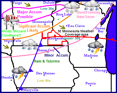
Attention nationally is on a 2013 Blizzard effecting the northeast U.S but will soon be turned to the next major winter storm with a low pressure system expected to impact the Upper Midwest starting tomorrow. The low will track from Nebraska across Southern Minnesota into Central Wisconsin. The track of this storm will produce major snowfall accumulations in South Dakota, Central Minnesota and Far Northern Wisconsin with the potienal for dangerous blizzard conditions across Western Minnesota. Significant snowfall will be seen totals in Central Minnesota and the rest of Northwest Wisconsin. The weather pattern will take a turn to a quieter one come Tuesday and Wednesday when sunshine will come back into the picture.
Local and Metro views
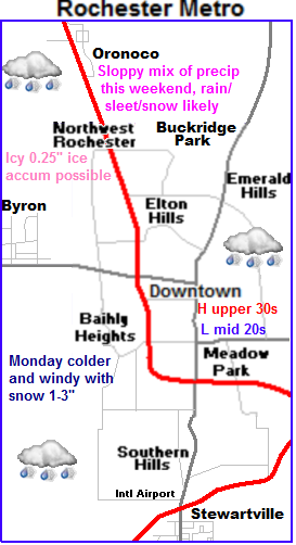
 Storm will bring a mixture of rain/sleet/snow to our area.
 What will this storm mean for our area? The answer to this is a mess. The center of the low will piratically pass directly over our area bringing us a wide range in precipitation from rain to sleet snow and freezing rain. Lets break this down into a timeline. Most Saturday will be precipitation free with highs in the mid to upper 30s with cloudy skies. Saturday Night freezing rain changing to rain will move in, this could cause a few issues up until the temperature rises above freezing. Sunday will be mild, temperatures will be in the upper 30s with rain and drizzle in the first part of the day. Some of the showers could have embedded thunderstorms. Rainfall amounts could approach quarter to half inch range. The problem if temperatures stay lower we may have a problem with accumulating ice. In either case Late Sunday a sharp cold front will approach and pass through temperatures will fall through the 30s changing rain to sleet then snow, the snow will last into the first part of Monday before ending with a few inches of accumulation the worst accumulation will remain north of our area up and around the Twin Cities. Conditions will start to improve Monday afternoon but it will remain windy with eventual clearing skies with highs in the mid 20s and lows in the low 10s Expect Tuesday and Wednesdays weather to be quiet once again with plenty of sunshine and seasonable temperatures in the upper 20s to lower 30s and lows in the low to mid 10s Winds will be light both days.
Impacts/accumulations
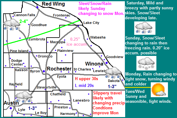
Problems facing us with this storm are Ice accumulation potienal which could reach 0.25" with freezing rain which could cause slippery travel 0.50" total precip amounts a possibility with total Snowfall accumulation 1-3" across the most of the area with 2-4" across the north. Strong winds on Monday gusting to 35MPH, which could cause some blowing and drifting of new snow cover that may fall.
Saturday, Mild, Partly sunny with highs in the mid 30s. Saturday Night, Sleet/Freezing rain developing changing to rain as temps rise above 32.F
Sunday, Freezing rain changing to rain and drizzle, thunder possible. Highs in the upper 30s. Sunday Night, Turning cold and windy, Rain changing to sleet/snow, lows in the upper 20s Rainfall amounts 0.25-0.50. Winds could gust to 25MPH
Monday, Light snow/blowing snow, Storm total accumulation 1-3" south 2-4" north, Windy and colder with highs in the mid 20s. Monday Night, Colder and breezy, Clearing skies with lows in the low to mid 10s
Tuesday, Seasonable, Sunny skies, not as windy with highs in the low to mid 30s. Tuesday Night, Clear skies, lows in the middle 10s.
Wednesday, Pleasant, Partly Cloudy skies with highs in the low to mid 30s. Wednesday Night, Increasing clouds, lows in the upper 10s to lower 20s.
Looking Ahead
Next chance of snow for us arrives Friday of this week the 15th as a low pressure system skirts across Southern Minnesota, this could bring a few inches of accumulation. The weekend looks sunnier, drier and seasonable. With a warming trend for the start of next week. Monday and Tuesday the 11th and 12th may be quite sunny and nice. After this point we get a few shots at a few cool. but not cold waves of air through the end of that week with occasional chance for light snows. No major snowstorms or cold snaps or warm ups for take matter. The forecast for the middle part of this month looks fairly typical.


No comments:
Post a Comment