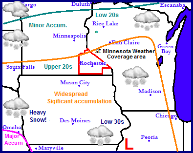
Attention is currently on a large storm system which will impact a very large part of the Upper Midwest coming up in the next couple days. A low pressure system coming from the Colorado area will move ENE in the vicinity of Missouri and Illinois, spreading widespread heavy snows across a large part of the states of Nebraska, Missouri, Iowa, South Dakota, Southern Minnesota, Western Wisconsin and Western Illinois. Major accumulations are possible in parts of Nebraka with this storm with amounts slowly tapering off as the storm moves northeast. What is surprising about this storm is the large area it is forecasted to hit. It has been awhile since this much of the Midwest has been looking at the threat for a snowstorm. It will remain dry and on the slightly cool side after the passage of this storm as the region possibly sets up for another storm on Monday and Tuesday of next week, possibly effecting the same areas as this one.
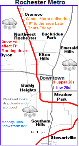
Local Weather and Metro View.
 The expected snowstorm will effect us here in Southeastern Minnesota. Heavy snow and sigificant accumulations effecting travel will be the main impacts from this event. What will be different about this event is winds will not be a problem like in past storms we've had. Challenges with this system are models are consistent with showing this system loosing some steam as the low moves northeast into Illinois, with the heaviest amounts well to our southwest in Nebraska and Iowa. Timing of the snow will be well after dark Thursday. Models seem to keep any snow forming coming into the area before 11pm Thursday night, however once the band moves in, snow will turn heavy at a fast rate. Heaviest snow will be Early Friday Morning effecting the early morning drive to work. Snow will taper off later Friday after afternoon and conditions will improve. There wont a significant amount of cold air behind this storm for the weekend. Skies will be cloudy with temperatures in the middle to upper 20s. Lows in the low to mid 10s both nights.
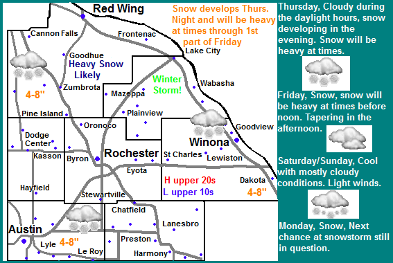
Thursday-Fridays storm accumulation and impacts
Accumulations will be 4-8" all around the entire area. The higher end of these amounts will be south of I-90 with lower amounts being north. Impacts related to the storm will be focused around heavy snow restricting visibilities and impacting travel Friday as well as the significant amounts listed. Winds will not be a problem in this storm as they have in past storms.
Wednesday, Sunny and cold. Light winds. Highs in the mid to upper 10s. Wednesday Night. Increasing clouds, lows in the mid single digits.
Thursday, Cloudy skies. Highs in the middle 20s. Thursday Night. Snow developing and becoming heavy at times. Lows in the upper 10s.
Friday, Snow, heavy at times in the morning. Storm total accumulations 4-8" Friday Night. Mostly Cloudy, lows in the middle 10s.
Saturday, Cloudy and cool. Highs in the mid to upper 20s. Saturday Night, Cloudy skies. Lows in the mid to upper 10s
Sunday, Mostly Cloudy skies. Highs in the low to mid 30s. Sunday Night, Cloudy skies. Lows in the lower 20s
Monday, A chance of snow. Possibly heavy at times. Highs in the 30s lows in the 20s.
Looking Ahead- Snowstorm threat increasing for Monday
Monday into Tuesday is the next chance for snow, and right now the models are coming together on another snowstorm impacting our area. It is too early to go into exact details, but it looks like more then 4" at this point, the snow tapers on Tuesday. Following this storm, it looks like skies will be mostly cloudy with temperatures slightly on the cool side through Saturday of this upcoming week. Sunday 2nd of March, maybe a slight chance of snow, accumulations do look very light. Towards the start of the week of Monday March 6th a ridge of high pressure starts to build to the west, with warming air building on the west coast possible moving east and delivering spring like warmth after the 1st week of the month. More on this later.


No comments:
Post a Comment