Regional Weather View weekend sneakpeak
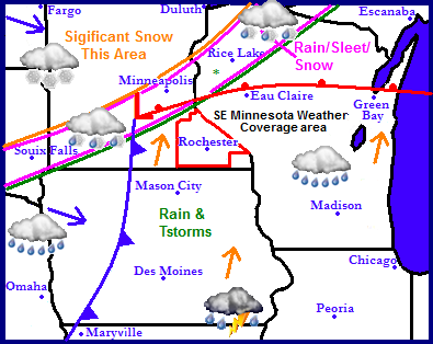
The map above is showing the system concerning this weekends expected event it's a sneakpeak, but a good idea what the models are coming into agreement with at this point. The models take the low pressure from this storm up in the Twin Cities area or just southeast of that area. This throws a plume of mild air northeast directly into our area and puts Southeastern Minnesota in a nearly all rain event. The GFS model shows the event happening in this order and time. Sunday Afternoon Widespread rain across the area with possibly some thunder. Temperatures warm to near 40.F Rainfall amounts 0.25-0.50 Early Monday after midnight, Cold front moves through, winds turn northwest and become strong temperatures drop below freezing light rains quickly end turning to light flurries, little to no snow accumulation. Any precipitation will be ending by Monday afternoon leaving behind a cloudy breezy day with highs in the middle 20s. Tuesday will be seasonal and Sunny with highs in the mid to upper 20s. A official forecast will be issued later in the weekend.


No comments:
Post a Comment