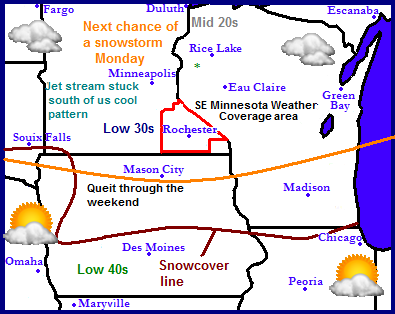
The weather pattern for the Midwest looks very cool and wintery like. The reason for this is because the jet stream has been stuck over the Midwest for the past few weeks. Which is also the reason for the very active pattern we have been in. The next chance of a snowstorm will be Monday but there is much disagreement between the model as to where this storm will track. Parts of South & North Dakota, Minnesota and Wisconsin look to be targeted at this time. Snowcover has receded north into Iowa but it does not look like it will be progressing much more north then this because after the storm passes through it will stay cool, but it will bring in a quieter and sunnier pattern.
Local and Metro views
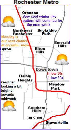
 For the local area expect a cool very wintery-like pattern. Because of a southerly placement of the jet stream to out south Spring-like airmass is having only brief visits to southern Minnesota. Saturday and Sunday will be more clouds then sun with highs in the upper 20s to lower 30s which is below the average of low to mid 40s which is where we should be this time of year.
Monday is the next chance of snow
Monday is our next chance for accumulating snow here in Southeastern Minnesota but there is significant disagreement among the forecast models on the placement of this storm. European models takes it more south which would bring minor to moderate (3-5") of snowfall accumulations to our area. GFS takes the storm more north keeping it north of Minneapolis, which would only bring light snow to our area with little to no snow. I decided for right now to go with that will probably see some light snow accumulations on Monday with the majority (heaviest) accumulations being to our north.
Cool into midweek but at least sunny!
Temperatures will remain well below normal into the middle to end of next week but at least a high pressure system will bring the sun back into the picture. High temperatures Wednesday will start off downright cold in the middle 20s, then moderate to the upper 20s to lower 30s Thursday and Friday. Friday we have a shot at maybe middle 30s, which is below normal but will feel good with the high sun angle and light winds that are expected.
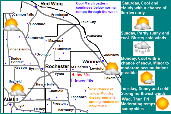
Saturday, Cool, Flurries possible early otherwise Mostly cloudy with breezy northwest winds to 20MPH. Highs in the upper 20s. Saturday Night, Cold, Partly cloudy with lows in the low to mid 10s
Sunday, Partly sunny skies, breezy cold winds. Highs in the upper 20s to low 30s. Sunday Night, Snow developing, Lows in the mid 20s.
Monday, Snow, possibly heavy at times. Possible Accumulations 2-4" Highs in the lower 30s Monday Night, Cold! Light snow and blowing snow, Windy with west winds gusting to 35MPH. Cold wind chills. Lows in the lower 10s to upper single digits.
Tuesday, Cold sunshine, breezy cold northwest winds. Highs in the mid 20s. Tuesday Night, Cold, lows in the upper single digits to lower 10s
Wednesday, Cool, Sunny, not as windy. Highs in the upper 20s. Wednesday Night, Cold, lows in the low to mid 10s.
Thursday, Sunny light winds, Warmer. Highs in the low to mid 30s. Thursday Night, Partly cloudy and chilly with lows in the upper 10s.
Friday, Partly Cloudy, highs in the low to mid 30s. Friday Night, Increasing clouds with lows in the upper 10s to low 20s.
Looking Ahead
GFS and European model are in complete disagreement in the long range forecast but I tend to lean towards a cooler side and pushing our spring-warmups farther and farther into March. The model shows the cold air sticking around at least for the next week, with maybe an end to that in the last week of the month. For next weekend 23rd and 24th looks sunny and cool but with the high sun angle in place we may see 30s for highs. The models are bringing in a warmer spring-like airmass to start off the last week March with the jet stream finally being allowed to possible go north of our area. If this were to take place we would see significantly warming temps and drastically melting snowcover. It must be taken into consideration the model may not be right with this trend and it could change back to a cooler trend, but at the same time this pattern were currently under wont stick in place forever so I would not be surprised if this turned out to be what happens. It is something we will just have to wait and see.


No comments:
Post a Comment