Regional Weather view
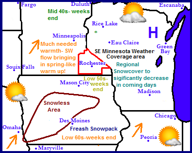
After a very long winter with snowstorms lasting through most of this month, spring is finally going to show its face here in the Upper Midwest. A high pressure system will bring calm weather to the region through the week and the jet stream will be moving northward. This will finally bring in warm air from the southwest. By weeks end 50s could be seen as far north as Southern Minnesota with 60s in Iowa. Currently there is a significant amount of snowcover across the region, but with warm temperatures expected this week this will be decreasing significantly over the next 7 days. Weather will remain fairly quiet through the work week with only a chance of light rain showers across Southern Minnesota and Iowa come Sunday.
Local and metro views
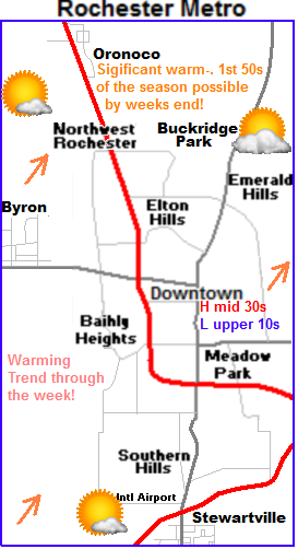
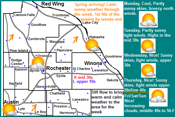
 It's quite difficult to contain my excitement by looking at the weather maps this week. Get ready for a real Spring-like warm up! Those that have been waiting for spring will finally get to see it this week as temperatures are expected to significantly warm up through the week. We will start off cool, and end out the week with the possibility of seeing our first 50.F temperature of the season. Monday and Tuesday will be cool and will feature more clouds then sun. North winds will be breezy at times. High temperatures in the middle 30s are expected with lows in the mid to upper 10s. Wednesday and Thursday we will have brilliant blue skies and light winds and it will feel very nice. Highs will be in the upper 30s to lower 40s. Lows will be in the lower to middle 20s. Friday, Saturday and Sunday we will likely see some clouds coming back into the picture with a slight chance of light rain shows on Saturday, the rain will be very light in nature and not cause any problems. Even with the clouds and precipitation we will see the full brunt of the spring-like warm up as south winds pump in warm temperatures in the lower to middle 40s Friday and Saturday and highs in the upper 40s to lower 50s on Sunday. This will be the warmest air we have seen in month and its going to feel quite nice and the is 4-8" deep snowcover that currently covers the area will be mostly gone by Sunday.
Monday, Breezy north winds, Partly sunny skies with highs in the mid 30s. Monday Night, Mostly cloudy with lows in the mid to upper 10s.
Tuesday, Decreasing clouds. Partly Sunny skies with highs in the mid to upper 30s. Tuesday Night, Mostly cloudy with lows in the mid to upper 10s.
Wednesday, Nice! Sunny skies, light winds. Highs in the upper 30s. Wednesday Night, Partly Cloudy, lows in the upper 10s to low 30s
Thursday, Nice! Sunny skies, light winds. Highs in the upper 30s to lower 40s. Partly cloudy, lows in the mid to upper 20s
Friday, Nice! Increasing clouds. Partly cloudy to partly sunny with highs in the middle 40s. Friday Night, Cloudy skies, lows in the upper 20s to low 30s
Saturday, Mostly cloudy with showers and the possibility of an thunderstorm. Highs in the mid to upper 40s. Saturday Night, Cloudy, chance of rain mixed with snow. Rainfall amounts around 0.25" lows in the lower 30s.
Sunday, Chances of light rain and snow early. Falling temperatures, Windy west winds gusting to 35MPH Highs in the upper 30s before falling Sunday Night, Windy with lows in the upper 10s. Winds gusting to 30MPH
Looking Ahead
Monday the start of the 1st week of April looks cold with highs only in the 30s with bluster winds. Tuesday April 2nd a warm front brings moves north and brings us rain showers then warm temperatures and calm weather for the middle of that week, 40s and 50s could be common. Saturday April 6th a strong low pressure system moves through and tracks from Nebraska to Northern Minnesota. This puts us on the warm side for the start but cold air is waiting to move south behind it. The model shows heavy rain showers Sunday April 7th possibly ending as light snow as cold air moves down form the northwest. Right after the storm is clears and sunny skies return out but cold temperatures remain over the area for a few days then temperatures moderate and warm up to more seasonal values around April 9th.


No comments:
Post a Comment