Map Image Legend Image

Iowa Weather Network Warnings Map

Iowa Weather Network Warnings Map

Winter Weather Advisory

Friday, December 14, 2012

Weekend system coming is as mostly plain old warm rain for the area. Healthy Ammounts 0.25-0.50" possible. Rain turning to wet snow near storms end, Little to no snow accumulation, Cooling down Sunday. Another system Thursday of this week?

Photobucket
Regional Weather View

The next storm system is pushing into the Upper Midwest from Nebraska this evening. The center of this storm will move across Iowa into Minnesota, The one will have a lot of warm air with it which means most of the precipitation will fall as rain over a large chuck of the region. It will also drag in very warm air as warm as the middle 50s as far north as Des Monies. Sunday as the storm moves away some areas will see wet snow mixing in as colder air moves southward. All the the accumulation though will be confined to Northern Minnesota and Wisconsin. Things will clear out region wide for the start of next week through the middle of next week. Snowless areas will be rather mild due to a lack of snowcover and cold air. It will remain dry through at least Wednesday until our next potential weather system moves in. See the extended forecast for this one.

Photobucket
Local and Metro Weather Views

PhotobucketFor our area the storms path will mean a mostly plain old warm rain event. Temperatures through most of the storm will be well above freezing and in fact may warm to near 40, so freezing rain will not be an issue. Saturday will be very wet with waves of moderate rain and drizzle throughout the day. Highs will be near 40, with lows in the middle 30s. Rainfall amounts will be near 0.25-0.50" to as much as 0.75" in localized areas. It is likely this rain and warmth will melt all of our current snowcover. As the storm pulls away from our area on Sunday the rain will turn to a few wet snowflakes, but by they most of the precipitation will end and there will be little to no snow accumulation. Snow will come to an end Sunday Morning. Sunday will be warm early in the morning, but turn cooler and blustery by the afternoon. It really wont turn too unreasonably cold after the storm passage for at least December standards anyway. Highs will still be in the upper 20s on Monday, with lows in the upper 10s. It will be dry, with clearing skies. Tuesday and even Wednesday temperatures will actually rebound to the middle 30s with more sunshine coming back into the picture. It might even approach 40.F with the lack of snowcover we will likely have by that time. Lows will be in the lower 20s each night.

Saturday, Very Mild, Rain, Could be moderate at times. Highs in the lower 40s. Saturday Night, Rain, Turning to wet snow late. Lows in the middle 30s. Little or no snow accumulation.

Sunday, Rain/Snow ending as wet snowflakes. Warm early, Turning cooler and blustery. Highs in the middle 30s early. Sunday Night, Cloudy, lows in the lower 20s.

Monday, Clearing skies. Highs in the upper 20s to lower 30s. Monday Night, Clear skies. Lows in the upper 10s to lower 20s.

Tuesday, Warm, Partly Cloudy skies with highs in the lower to middle 30s. Tuesday Night, Partly Cloudy, Lows in the upper 10s to lower 20s.

Wednesday, Warm, Partly Cloudy, increasing clouds with highs in the middle to upper 30s. Wednesday Night, A chance of snow developing, Lows in the middle 20s.

Looking Ahead

The next storm gaining intimidate attention impacts the area as early as next Thursday, it looks like it could be a bigger storm and it really needs to be watched. Right now the model takes the central of the storm through central Iowa, which means our area would be on the all snow side and it would not turn to rain. This storm does hold snow storm potential to it with pretty hefty accumulations. Question is will the models hold it in our area. It will continued to be watched through the week. It turns quite cold for Friday December 21st and remains cold through next weekend and into Christmas. If we get that projected snowstorm next week we would likely have a very good chance at a white Christmas. Cold dry air continues to funnel over Southeastern Minnesota towards the end of December before a warmup as we approach the very end of the month. 

Monday, December 10, 2012

Snowstorm Report Wide-Range In Totals From Major Accumulations In Northern Parts of The Area With 13.0" At Red Wing to Minor Ammounts In The Central and Southern Areas.

Photobucket
Heavy Snow during the afternoon hours of December 9th 2012

A very strong weather system effected the area late this weekend and brought a wide range of snowfall totals here in Southeastern Minnesota ranging from minor to major. Going to the beginning of this storms history, it originated in the Western U.S where it then moved into South Dakota and strengthened into a Winter Storm. The low pressure system tracked right along I-90 and over Southeastern Minnesota. Snow, heavy at times began filtering into Minnesota by late Saturday, and by early Sunday it was in Eastern Minnesota and our area. Snow lasted off an on in intensity through Sunday into early Monday morning. because of this the track of the low there was a well defined line in snowfall amounts that separated the major snowfall amounts which fell in Central Minnesota to the less significant totals that fell in our area, the southern part of our state. Winter Storm warnings were posted for much of Minnesota, with Blizzard Warnings in Southwestern Minnesota. In our area Goodhue and Wabasha counties were initially the only counties under Winter Storm Warnings until the NWS sent Dodge, Olmstead and Winona counties under warnings. This was mostly due to winter storm conditions being met in the far northern parts of these counties. The rest of the area was put under an Advisory.
Photobucket


Photo given credit to Dave W. from Isanti,Minnesota 15.50" fell December 9th

This photo explains the true power of this storm to our north in Central Minnesota.The Minneapolis/St Paul metropolitan area and areas north and south and east into Western Wisconsin which were in the worst of this storm were burried under 12-16" of new snow, enough to shut down area business and schools even well after the storm ended. Record snowfalls were seen at Minneapolis International Airport with this one.The photo above is from a friend of mine from the City of Isanti,Minnesota about 60 miles north of Minneapolis where 15.50" of snow fell. This was initially much more snow they they were expecting for that area, but the storm slowed down which allowed for longer timed accumulations. In Western Minnesota high snowfall amounts were blown by 50MPH winds creating blizzard conditions near the South Dakota boarder, many roads closed in this area because of blowing snow. The cut off from the very heavy snow amounts in central Minnesota to lighter amounts here seems to be Red Wing to Cannon Falls in our area northward. My hometown area received 13.0" of snow from this storm. He said he had 1.30" of water from this incredible snowpack amount!
Photobucket


St Marys Park Rochester,MN December 9th

Here in Southeastern Minnesota we dealt with amounts ranging 13.0" inches in Red Wing to 2.30" in Austin. The cut off line in areas that saw major amounts like this was pretty much North of Zumbrota northward. The farther north you were in the area, the more snow you saw, even 10 miles made a big difference in how much snow you saw. There were multiple impassible side roads in Goodhue County during the storm, but luckily this snow came with no wind so road closers of major were minimal to none. It was also helped the storm hit on a weekend. In Rochester the storm was much more minimal, we had moderate snow off and on with one band of heavy snow pictured at the top of this post. My snowfall accumulation was 4.25"  tieing the highest accumulating snowfall last year which also means this is the still the highest accumulating snowfall I've seen since I moved to Rochester. We are continuing our snowstorm-free streak though, we have yet to see an official Winter Storm here in Rochester which is considered 6.00" of snowfall in one event or more. With this snow, I will admit after going through a record streak of snow free days I kinda missed the look of a true Minnesota winter, and the moisture is very much needed.

The NWS in Channhassen released a really neat map showing snowfall totals across the state. That map can be seen HERE

Photobucket

Interesting Notes from this event:  
Red Wing had the highest reported snowfall amount of 13.0"   
4th longest snow free streak on record in Rochester, 293 days without accumulating snow between February last year and yesterday. 
1st accumulating snow of the season for Rochester and much of the area.
This system tied the highest accumulating snowfall event from last year in Rochester. 
Austin had the lowest reported amount of 2.30"
Rochester continuing streak of snowstorm free days ( 6.00" or more) 2 years since one hit.


Saturday, December 8, 2012

Winter Storm Shifting South increasing totals in SE Minnesota-Accumulating snowfall likely 2-5" with spots 6+ inches of snow Sat Night to Sunday, Travel impacts with heavy snow and blowing snow. Brief shot of Arctic Air moves in Monday with highs in the low 10s. Updated x1

Photobucket
Regional Weather View.

It is more then apparent now the big talk in weather for the weekend is a developing Winter Storm forecasted to impact northern parts of the Upper Midwest. A low pressure system will slide through Nebraska, then northeast through Iowa and Wisconsin. This set up will has the potential to bring heavy snows with significant snowfall to Central and Northern Minnesota and Northwestern Wisconsin. With minor accumulations immediately south of this area. Northwest winds will develop behind this storm system which will kick up blowing snow across much of Minnesota and Wisconsin. The strongest shot of Arctic air so far this season will proceed this storm on Monday. Tuesday into much of next week we can expect a slow warming trend with cloudy skies prevailing much of the week.
Photobucket


Local and Metro views.


PhotobucketWinter Storm Shifting south increasing totals across the area, minor to significant accumulations possible!

Saturday, the mentioned storm system will be working its way into our area. Expect most of Saturday to be cloudy with highs in the mid to upper 30s. Snow will start Saturday Night with lows in the upper 20s, Current forecasts are trending this storm farther south, bringing the heaviest accumulating in this storm of snows in the range of 8 to possibly even 10" range over the Twin Cities area. While we here in Southeastern Minnesota will be on the more southern side of this system, meaning accumulations will be in the 2-5" inch range give or take. Still I don't want this system under played for Southeastern Minnesota because of several reasons, its the 1st bigger snow system we have seen in nearly a year due to last years snow drought, and second, heavy snow is likely, and travel impacts will be quite high, and especially heightened due to the 1st real accumulating snow of the season. Sunday is when the heaviest snow will fall, we can expect temperatures in the low 30s during this snowfall. Sunday Night and Monday will be very cold, as a brief arctic airmass flows southeast. highs, Lows Sunday night will approach the lower single digits, and with wind chills, it will feel well below zero at times. Highs Monday will only be in the low to mid 10s with our fresh new snowpack Tuesday through most of next week looks dry, but lots of clouds will stick around with temperatures slowing rising through the week.

Accumulations and timing Breakdown.

Current model data has shifted the storm slightly south bringing the change of significant snowfall into north parts of our area Accumulations still look to be highest in northern part of the area, Cannon Falls and Red Wing areas look to receive 6 or more inches. Which makes it a low end winter storm. Central Area accumulations have been increased to 3-5" this would include areas around The Rochester Metro Area, Dodge Center, and Lake City. Southern areas look now to recive 2-4" of snow, areas in this category include Austin, Winona and Preston. The timing for this snow will start late Saturday after dark. The snow will start off  light but overnight Saturday into early Sunday, moderate to brief Heavy snow will envelop the area. To make conditions worse Northwest winds 25-35MPH will kick up blowing and drifting snow Sunday afternoon. The worst travel times will be late Saturday into early Sunday before 1pm. After 1pm conditions will improve, but it will still be windy blowing and drifting snow. Very cold conditions will develop Sunday Night into Monday with wind chills possibly dropping into the -10.F or colder range, with actual temperatures in the lower single digits Sunday Night rising only to the lower to mid 10s Monday, People in Southeastern Minnesota should take time to prepare for our 1st significant storm system of the winter season and remember winter driving skills and to dress for cold weather. It has been awhile since these conditions have effected the area.

Saturday Night, Snow developing late, could become heavy at times.  Lows in the upper 20s.

Sunday, Snow, Windy with blowing and drifting snow. Snow will be heavy at times early. Strong Northwest winds developing gusting 25 to 35MPH, System total accumulations 2-4" south, 3-5" central, 6+ inches north. Highs in the lower 30s. Sunday Night, Very Cold! Lows falling to the mid to upper single digits. Very cold wind chills well below zero. Winds could gust to 30MPH

Monday, Very Cold! Breezy with wind chills below zero, Partly Sunny with a chance of wind driven flurries, Highs in the lower to mid 10s Monday Night, Increasing clouds, lows in the upper single digits to lower 10s.

Tuesday, Mostly Cloudy skies, with a slight chance of flurries, Warmer with highs in the middle 20s. Tuesday Night, Cloudy skies, lows in the upper 10s to lower 20s.

Wednesday, Mostly Sunny, warmer Highs in the lower 30s. Wednesday Night, lows in the middle 20s.

Looking Ahead

Weather for the rest of the work week looks quiet and dry with fairly seasonably temperatures. The next storm system will possibly come in this weekend. Beyond this and it will not be updated at this time due to the upcoming weather event.

Wednesday, December 5, 2012

Rain/warmth tomorrow. Then 2 separate systems could bring snow accumulations for the weekend. One Friday, and one Sunday. Early release forecast.

Photobucket
Regional Weather early release forecast.

Thursdays System This is an early release forecast concerning the precipitation for Friday, Saturday and Sunday. Multiple weather systems are going to move through over the course of the next 4 days. One will move through tomorrow bringing rain and drizzle, along with a quick shot of warm air with temperatures rising into the 50s. A cold front will move through later tomorrow dropping temperatures back into the 30s.

Fridays System Friday a weak weather system will move through Southern Minnesota and Northern Iowa. Right now it looks to bring light snows to our area. Maybe a dusting to an inch for Southern Minnesota

Sat Nights/Sundays Weather System. Another 3rd weather system will pass through Saturday Night into Sunday. The models have been kinda all over the place with this storms location and amounts. Right now I will stay on the safe side an say 2-3" are definitely a possibility for this system. I will have more updates as they become available.


Monday, December 3, 2012

Record highs broken today as highs reach the lower to middle 60s.

Photobucket
Neighborhood December 3rd 2012

An all to common December scene if you compare the start of this December to last year, Snowless.  A passing warm front along with lack of snow on the ground has allowed temperatures to rise to record levels today into the lower to middle 60s. A record high of 62.F was reported at Rochester Airport, breaking the old record high of 59.F set back in 1962. What was rather odd about this warm up is that 60s were reached even though very little sun was seen. It has one wondering what temperatures could have been reached has the sun shined all day long!
Photobucket

Daffodil sprouting December 3rd 2012

Daffodils in December? This year it is a reality. The flip flops in weather we've been having where we have a week of cold snaps, then a warm up has fooled some of the Daffodils into thinking it is spring! Sprouting daffodils in December is quite odd, but it will not harm them as long as it cools down before they grow to much. What will likely happen here is that they will stop growing until we get longer lasting spring warm ups next year.

Photobucket
 Highs Monday December 3rd.

Overall the areas highest temperature was from Preston which reached a toasty 65.F. The coolest was an unoffical station Byron, which had a high of 58.F

Thursday, November 29, 2012

Drought increasing across the area. Olmstead, Wabasha, Winona counties now in Severe Drought. Extream Drought Mower County.

Photobucket
Minnesota Drought Monitor Thursday November 29th update.

The drought that we are currently in is continuing to get progressively worse here in Southeastern Minnesota. Severe drought has expanded and now includes all of Olmstead, Western Fillmore, Northwestern Winona, Southern Goodhue, and most of Wabasha counties. Severe Drought continues to effect Northeastern Mower and Dodge counties. Severe drought includes cities like Dodge Center, Kasson, The Rochester Metro, Wabasha, Plainview and Eyota. Extreme Drought continues to effect Mower county including the of Austin. Even though its late in the season and agricultural crops, yards and gardens are no longer needing much water, the drought has continued to effect the area, especially in lakes and river levels which are well below normal. Also trees and shrubs and grass which depends on fall watering have gone without significant rains which means that may be prone to damage by cold drying winds. We can also expect that yards will likely have competition with weeds next year because of opening spaces from dying grass.

Below is a list of deficits for the year starting January 1st and back in August of 2011 which when our drought truly began.

Deficits 2012 year/Since August 1st 2011


                              2012 year                 Since August 1st 2011
Austin                         -12.38"                    -20.94"
Rochester Airport        -8.47"                     -16.51"  
 Preston                       -7.27"                      -15.39"
Lanesbro                     -6.42"                     -13.14"
Wabasha                    -5.18"                       -13.88"
 Winona                     -6.49"                        -12.56"
Lake City                    +1.48"                       -6.75"


Sunday, November 25, 2012

Very dry this week. Starting off cold with moderating temperatures through the week. A return to mild & dry weather by the weekend with highs appoarching 50.F

Photobucket
Regional Weather View.

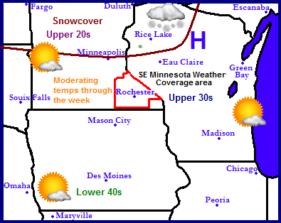
A very calm weather pattern will continue across the Upper Midwest for the the week. The only weather of interest will be around the south shore of Lake Superior where lake effect snow will produce a few inches in that area. Weather everywhere else will be calm and very dry. Temperatures will start off cold region wide in the upper 20s in snowcovered areas of Northern Minnesota and Wisconsin to the upper 30s and lower 40s across the south. Temperatures will moderate through the week and by weeks end highs will be in the low 40s across snowcover areas, to near if not in the 50s across snowless areas. The snowcover will also be shrinking quite a bit this week as warmer temperatures melt the snow.

Photobucket
Local and Metro views.

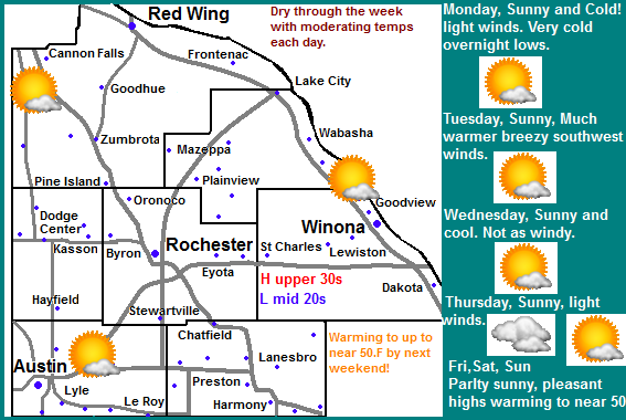
Across the local area the weather pattern will mean continued very dry weather. It will start off Sunny Monday through Thursday before clouds increase on Friday and Saturday. Temperatures will start of quite cold with highs only in the low to mid 20s on Monday, and lows falling into the upper single digits to lower 10s. This will be the coldest day of the week because as the week goes by temperatures will moderate and warm significantly. Tuesday will be a lot warmer in the upper 30s but strong southwesterly winds will make if feel colder. Wednesday it cools off slightly into the middle 30s and lows in the low to mid 20s, before it starts to warm up on Thursday and Friday with highs in the upper 30s and lows in the low to mid 30s. Clouds will increase on Friday and Saturday to a partly sunny skies. Saturday will be very pleasant, highs will be in the middle to upper 40s with lows in the mid 30s. Sunday will be nearly just as nice. Highs will be in the low to mid 40s with lows in the 30s.

Monday, Sunny and Cold! Highs in the middle 30s. Monday Night, Clear Skies, Very Cold! Lows in the upper single digits to low 10s.

Tuesday, Sunny, Warmer. Breezy with Southwest winds gusting to 25MPH and Cold wind chills. Highs in the upper 30s. Tuesday Night, Clear skies, Lows in the low to mid 10s.

Wednesday, Sunny skies. Highs in the mid to upper 30s. Wednesday Night, Clear, lows in the low to mid 20s

Thursday, Sunny skies. Highs in the upper 30s. Thursday Night, Increasing clouds. Lows in the in the mid to upper 20s

Friday, Partly Sunny, Highs in the upper 30s to lower 40s. Friday Night, Mostly Cloudy, lows in the low to mid 30s.

Saturday, Warm! Partly Sunny with highs in the middle to upper 40s. Saturday Night, Partly Cloudy, lows in the middle 30s.

Sunday, Sunny, Warm! Highs in the middle 40s Sunday Night, Clear skies, lows in the upper 20s to lower 30s.

Looking Ahead

If you're looking ahead to a potirnally snowy future this will not be the forecast for you. As we end November well below normal in snow, December looks to start off very dry. There is hope however if you read toward the end. The long range charts say we will head into December dry and quite mild. Tuesday December 4th a cold front will pass through possibly bringing a little bit of light rain showers It really looks like hardly anything at all. Wednesday the 5th a weak passing weather system to our south will bring a warm front back in possibly sparking a few quick rain showers on this day. The model shows this storm really getting going to our east spreading significant rains and snows to the east and north of Southern Minnesota, while remaining dry and cool here. We do see temperatures cooling off substantially behind this system, It actually looks fairly cold starting Saturday the 11th. Sunday the 12th a low pressure system passes to our south and brings a chance for a snowstorm across Southern Wisconsin, It shows that this system will remain well east of our area. We will see another show of reinforcing cold air for us behind it though. The models then show several systems coming in from the west and missing us to the south. I see no big snowstorms anytime soon for Southeastern Minnesota. There is hope however, the model runs may change the course of a few of the systems we could be in for a chance of a snowstorm if the path of one changes. It will just be something to watch for over the next few days/weeks.