Regional Weather View.
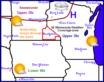
A very calm weather pattern will continue across the Upper Midwest for the the week. The only weather of interest will be around the south shore of Lake Superior where lake effect snow will produce a few inches in that area. Weather everywhere else will be calm and very dry. Temperatures will start off cold region wide in the upper 20s in snowcovered areas of Northern Minnesota and Wisconsin to the upper 30s and lower 40s across the south. Temperatures will moderate through the week and by weeks end highs will be in the low 40s across snowcover areas, to near if not in the 50s across snowless areas. The snowcover will also be shrinking quite a bit this week as warmer temperatures melt the snow.
Local and Metro views.
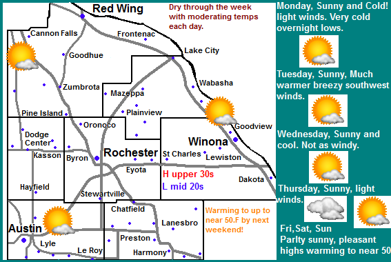
Across the local area the weather pattern will mean continued very dry weather. It will start off Sunny Monday through Thursday before clouds increase on Friday and Saturday. Temperatures will start of quite cold with highs only in the low to mid 20s on Monday, and lows falling into the upper single digits to lower 10s. This will be the coldest day of the week because as the week goes by temperatures will moderate and warm significantly. Tuesday will be a lot warmer in the upper 30s but strong southwesterly winds will make if feel colder. Wednesday it cools off slightly into the middle 30s and lows in the low to mid 20s, before it starts to warm up on Thursday and Friday with highs in the upper 30s and lows in the low to mid 30s. Clouds will increase on Friday and Saturday to a partly sunny skies. Saturday will be very pleasant, highs will be in the middle to upper 40s with lows in the mid 30s. Sunday will be nearly just as nice. Highs will be in the low to mid 40s with lows in the 30s.
Monday, Sunny and Cold! Highs in the middle 30s. Monday Night, Clear Skies, Very Cold! Lows in the upper single digits to low 10s.
Tuesday, Sunny, Warmer. Breezy with Southwest winds gusting to 25MPH and Cold wind chills. Highs in the upper 30s. Tuesday Night, Clear skies, Lows in the low to mid 10s.
Wednesday, Sunny skies. Highs in the mid to upper 30s. Wednesday Night, Clear, lows in the low to mid 20s
Thursday, Sunny skies. Highs in the upper 30s. Thursday Night, Increasing clouds. Lows in the in the mid to upper 20s
Friday, Partly Sunny, Highs in the upper 30s to lower 40s. Friday Night, Mostly Cloudy, lows in the low to mid 30s.
Saturday, Warm! Partly Sunny with highs in the middle to upper 40s. Saturday Night, Partly Cloudy, lows in the middle 30s.
Sunday, Sunny, Warm! Highs in the middle 40s Sunday Night, Clear skies, lows in the upper 20s to lower 30s.
Looking Ahead
If you're looking ahead to a potirnally snowy future this will not be the forecast for you. As we end November well below normal in snow, December looks to start off very dry. There is hope however if you read toward the end. The long range charts say we will head into December dry and quite mild. Tuesday December 4th a cold front will pass through possibly bringing a little bit of light rain showers It really looks like hardly anything at all. Wednesday the 5th a weak passing weather system to our south will bring a warm front back in possibly sparking a few quick rain showers on this day. The model shows this storm really getting going to our east spreading significant rains and snows to the east and north of Southern Minnesota, while remaining dry and cool here. We do see temperatures cooling off substantially behind this system, It actually looks fairly cold starting Saturday the 11th. Sunday the 12th a low pressure system passes to our south and brings a chance for a snowstorm across Southern Wisconsin, It shows that this system will remain well east of our area. We will see another show of reinforcing cold air for us behind it though. The models then show several systems coming in from the west and missing us to the south. I see no big snowstorms anytime soon for Southeastern Minnesota. There is hope however, the model runs may change the course of a few of the systems we could be in for a chance of a snowstorm if the path of one changes. It will just be something to watch for over the next few days/weeks.


No comments:
Post a Comment