Regional Weather View
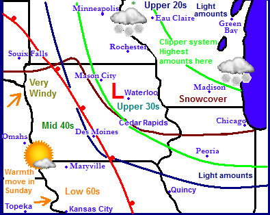
Regionally there will be a clipper system moving through areas of Iowa, Minnesota and Wisconsin where several inches and heavy snow will be seen on Saturday. It will be a quick mover that will follow the jet stream and there will be a very sharp cut off from higher to lower amounts. South and west of the blue line above will see no snow.. Sunday the jet stream will move northeast sending a breif shot of warm front across the rest of Iowa and into Southern Minnesota. In areas with no snowcover 50s and 60s will be seen, with 40s in most of the rest of Iowa. Temperatures will not rise above freezing in many areas of Minnesota and northern Wisconsin. The warm up will be short lived because by Tuesday an arctic cold front will slide across the region bringing much colder temperatures. This front will come through most of the region dry.
Local Weather View
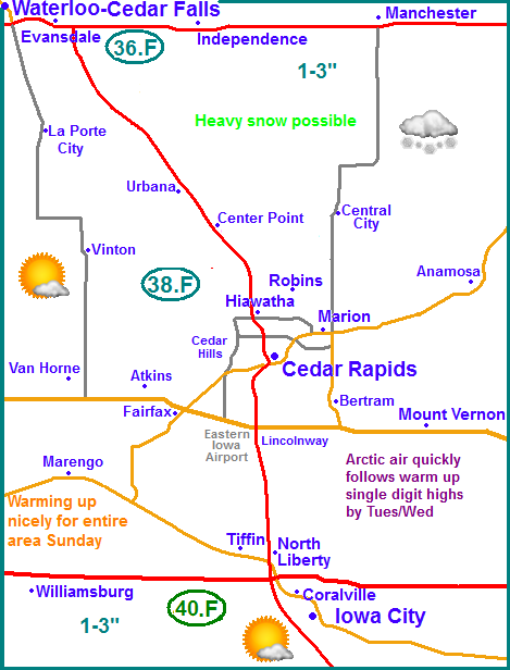
Locally this clipper system is causing a little bit of a problem in forecasting the weather because it will be such a close cut off line. The models have shown a westward shift, which means increased snowfall for all areas. At this point now the models depict all areas seeing 1-3" of snow on Friday night into Saturday Morning, this will mainly include all areas. Temperatures will slowly rise Saturday into the lower 30s in response to a slowly approaching warm front. Sunday will be nice across Eastern Iowa, under sunny skies and southerly breezes, highs in the lower to middle 40s can be expected, especially areas with little to no snowcover. Monday, an arctic cold front sweeps through the state, it will be sunny but the high which will be in the lower 30s will likely be reached in the morning, with temperatures steady or falling through the day and falling to the single digits for lows. Tuesday will be sunny and cold, but winds should be lighter. Highs will only be in the lower 10s, and in the upper single digits in areas with more snowcover. Lows will be on either side of zero. Wednesday will be sunny with highs in the lower to middle 10s and lows in the mid single digits. Thursday into Friday next week it will be increasingly cloudy ahead of our next shot at snow, but at this point amounts look light.
Friday, Clearing skies, cold and blustery with cold wind chills. Highs in the upper single digits to lower 10s. Friday night. Snow possible late Partly cloudy with lows in the mid single digits.
Saturday, Cloudy skies with snow developing, possibly moderate at times. 1-3" all area. Highs warming to the upper 20s to lower 30s.. Saturday night, lows in the mid 10s.
Sunday, Sunny and pleasant with southerly breezes, highs in the upper 30s to mid 40s. Sunday Night, Clear skies with lows in the lower 20s to upper 10s.
Monday, Sunny skies with winds turning north and becoming blustery. Highs in upper 20s to mid 30s. Monday night, increasing clouds with lows in the mid single digits.
Tuesday, Sunny and cold, highs in the lower 10s to upper single digits. Tuesday Night, Cold, Clear skies with lows on either side of zero.
Wednesday, Sunny skies with increasing clouds late. Highs in the mid 10s. Wednesday Night, Cloudy with lows in the mid single digits.
Thursday, Cloudy with a chance of snow developing in the afternoon. Amounts 1-2" into Friday morning mainly northeast. Highs in the mid to upper 20s. Thursday Night. A chance of snow, lows in the mid 10s.
Looking Ahead, After Thursday and Fridays snow, Saturday looks cold and sunny with highs somewhere in the single digits, and Sunday the 26th looks to warm into the 10s. After this a pattern change is likely and it gets more interesting as the jet stream sets it self up to produce multiple clippers. Monday the 27th is the 1st of many possible clippers according to the model. Another one follows right on its heals for Tuesday, this one looks a bit heavier especially to our Northeast. Wednesday looks cloudy and warmer likely somewhere around the 20s. Then Thursday the 30th the models are starting to show a possible developing snowstorm over the middle of the country bringing much of Iowa heavy snowfall and possibly some strong winds. This storm will need to be watched as it looks significant. Arctic air follows this storm drying our weather our as we head into the month of February.


No comments:
Post a Comment