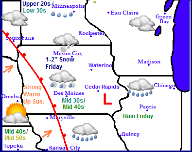
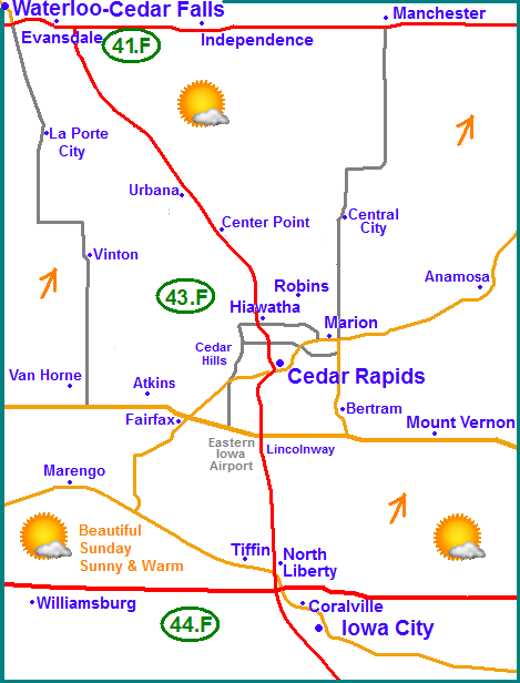
Weather across the region will be warming up significantly after our outbreak of arctic air last week. Some places will even gone from below zero weather last week to rain this week. A weak weather system moving across Southeast Iowa will bring rain to the 1/3rd of Southeast Iowa, and sleet and snow along a corridor roughly from Des Moines to Waterloo. Northwest of there, Northern Iowa, Southeast Minnesota and parts of Wisconsin, Mason City to Rochester will see snow with minor accumulations. This feature will be fast to move out as a strong warm front from the southwest brings a push of very mild air into the area. Highs listed above are Fridays highs compared to Sundays highs. Come Sunday temperatures as warm as the 50s could be felt as far north as far southern Iowa. With highs near 60 as one nears Central Missouri. It will be a dry week after the said storm system above passes with temperatures swinging up and down but generally in the 20s to middle 30s.
Local Weather View
Saturday we will get a brief cool down to the 20s and 30s being this storm, before the big warm up Sunday. I have raised forecasted highs for tomorrow due to the fact that areas to our southwest have little snowcover and the warm up appears stronger then first anticipated. Under sunny skies I believe highs will be as listed above, in the upper 30s to middle 40s in the south. If more snowcover can melt Friday it will help us even have a higher shot at warmer temperatures. Most of our snowcover will be melting away this week regardless of Fridays highs/rain as skies will remain sunny with several days with highs around the 32.F mark, accept for Wednesday when we get a brief shot of cooler air before it warms back up, Weather will be dry from Saturday through Thursday next week.
Friday, Sleet/snow across the North, Rain to the south. Highs in the low 30s north to mid to upper 30s south. Snow accumulation across the north around 1" Friday Night, Snow possible with light accumulations. Lows cooling in the middle 20s
Saturday, Partly Cloudy skies with light winds. Highs in the upper 20s to lower 30s. Saturday night, Partly Cloudy with lows in the upper 10s.
Sunday, Sunny and warm with southerly breezes. Highs in the upper 30s north to lower to middle 40s south. Sunday Night, Increasing clouds with lows in the mid 20s
Monday, Cooler with northerly breezes. Cloudy skies with Highs in the upper 20s to lower 30s. Monday night, Cloudy with lows in the low to mid 20s.
Tuesday, Breezy, Partly Sunny skies with highs in the lower to mid 30s. Tuesday Night, Mostly Cloudy and breezy with lows in the mid 10s
Wednesday, Colder with cool wind chills. Windy with highs in the low to mid 20s. Wednesday Night, Cloudy skies with lows in the mid 10s.
Thursday, Sunny skies and warmer. Southerly breezes. Highs in the middle to upper 30s. Thursday Night. Turning colder and blustery with lows cooling to the in the lower 10s.
Looking Ahead
Friday the 17th an chunk of an arctic airmass will moved southeast through the Midwest and deliver us another spell of cold temperatures. It comes in dry, however a clipper system could produce some snow in our area Saturday the 18th, but most of this will be confined to Northern Iowa. Sunday the 19th we begin a warming trend, which really comes into play between the 20th and 21st. High temperatures could have a run and the lower to middle 40s category. Wednesday the 22nd a storm system spreads rain to our south to areas of Missouri, Southern Illinois and Kentucky. This leaves us dry but brings in a brief shot of slightly cooler air. After this time frame the jet stream then sits directly over Iowa leaving us more prone to storms. January 24th shows a chance of some wet snows over Iowa, but it does not look significant.At the very end of the run, the 25th model shows a better organized storm moving towards Iowa. It has the potienal to be rain across the southern half and snow across the northern half, but it is far to early to determine where this storm will go at this time.


No comments:
Post a Comment