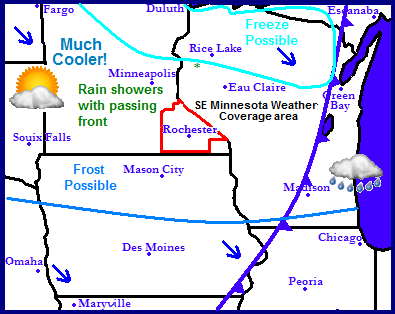
Regional Weather view.
A very sharp change in the pattern is expect for the start of the new work week. A strong cold front will plow through the region bringing with it the threat for much need showers across Minnesota and Wisconsin. After the passing of the front, the 1st real cool air of the season will make its way southward from Canada, bringing with it frost and freeze potential for areas of the north. The weather will be sunny, chilly and dry for Tuesday, with increasing warmth Wednesday and Thursday with sunshine and dry weather expected across much of the region.

Local and Metro view.
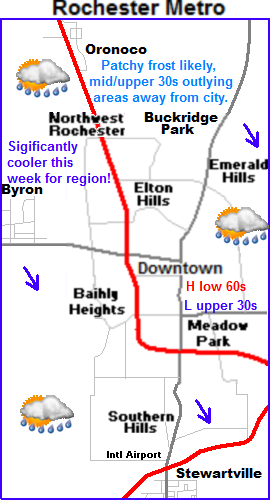
Significantly cooler and wetter for Monday with Frost potential Monday Night. Continued cool for Tuesday
A very sharp cold front will be felt across the area starting tomorrow as the coolest air of the season pours in. Monday will be cloudy and very cooler with showers and temperatures in the 50s, being 20 degrees cooler then highs on Sunday. The rain will be widespread in the morning but will mainly be of the light variety, amounts will be minor and range from around 0.10 to 0.30" of an inch. The main story with this front will be the much cooler temperatures. After highs in the 50s on Monday skies will clear out in the evening hours allowing for temperatures to really drop tomorrow night. Patchy frost is likely with lows topping out in the middle to upper 30s in typical cool areas and low spots. Warm spots, and inner city parts of Rochester should be safe from any frost as lows fall into the upper 30s to lower 40s. Tuesday will be sunny and dry with highs in the upper 50s to lower 60s. Tuesday night will be another one with lows in the low 40s with possibly a few upper 30s in a few spots.
Gardeners Note: Annuals and tender crops can be harmed in the expected temperatures, do not forget to cover or bring indoors!
Warmer Wednesday and Thursday.
Wednesday warm air surging ahead of our next system will be much warmer then Tuesday. It will be sunny with highs in the lower to mid 70s on Wednesday with breezy south winds gusting to 35MPH. Thursday will also be sunny and dry with highs in the mid 60s and lows in the low to mid 40s.
Monday, Chilly! Rainshowers in the morning then decreasing clouds. Highs in the upper 50s to low 60s. Monday Night, Very Chilly! Clear skies with lows in the mid to upper 30s. Patchy frost likely, outlying areas away from inner city Rochester, lows in the mid to upper 30s, to upper 30s to lower 40s, inner city Rochester.
Tuesday, Chilly and sunny, with light winds. Highs in the upper 50s to lower 60s. Tuesday Night, Chilly, Clear skies with lows in the upper 30s to lower 40s.
Wednesday, Warmer sunny and breezy. Highs in the lower to mid 70s. Southwest winds gusting to 35MPH Wednesday Night, Clear skies lows in the mid to upper 40s.
Thursday, Sunny skies, light winds. Highs in the mid to upper 60s. Thursday Night, Clear skies lows in the lower to mid 40s.
Looking Ahead.
Friday a small weather system will develop in Minnesota and bring the chance for showers and a few thunderstorms to our area, then the systems cold front passes through bringing windy northwest winds and sharply cooler conditions for Saturday. What is interesting is some of the models suggest a snow flurries threat in far northern Minnesota with this system. For our area it would likely be a coo day with a frost threat. Sunday, through Tuesday of the upcoming week looks fair and dry. A warmer trend makes its way in for Wednesday, before a front brings a chance of showers on Thursday. It dries out with about average highs for the weekend of the 30th. Then the models want to hint on a bigger weather system for Monday October 1st bringing with it widespread heavy rains for much of Iowa, Southern Minnesota and Wisconsin. We will have to see how long this holds. It would be quite good news for drought stricken areas if this continued to show over the next few weeks!


No comments:
Post a Comment