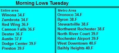
Lows this morning, September 18th 2012
It was a chilly morning across the area thanks to the arrival of a chilly, fall-like airmass from the north that arrived early Monday on blustery northwest winds The 1st frost was observed with these temperatures in many spots. Skies were slow to clear yesterday but once they did towards evening things became mostly clear, this helped influence the temperatures last night. Lows across the area were generally in the mid to upper 30s with the exception some extremes, like Winona and Zumbrota, which both had a low of 34.F, the landscaped influenced this some as cooler air sinks into the lower valleys that those two cities are located. In these locations frost was probably more widespread and possibly more damaging. On the other side of the spectrum, areas of deep within the city of Rochester had lows in the 40s because of a heating effect from the abundance of buildings and heated surfaces like parking lows and roads.
Interesting statement
The low at my station in West Downtown Rochester was 40.F Interestingly enough though, I did see a tinging of very light frost in the yard this morning even though the low was 40.F. The frost was so light that it was difficult to see and did not harm any vegitation. It was possible for the frost to occur because air cools as much as 10.F on clear nights as you approach the grounds surface, and it warms as you go up in feet to a certain extent. My weather station is up 6 feet above the ground because that is national standards for height. Even this being the case it is still this is the warmest temperature at 6 feet that I've seen frost occur on the ground.


No comments:
Post a Comment