Regional weather view
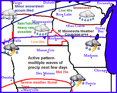
A very active weather pattern is setting up across the Upper Midwest this week with quite a contrast in terms of weather to start off the week. Monday and Tuesday, the regions 1st threat for severe weather exits across southern Iowa, further north the stationary front/warm front will bring the warm airmass associated with this storm systems as far north as far Southern Minnesota. Waves of showers and thunderstorms with rain changing to a wet snow across the far is expected to move through the region the next few days. Accumulating snows are a possibility across Northern Minnesota, elsewhere heavy rain is a likelihood. Wednesday another system will move through bringing cold air southward and bringing the threat for snow farther south into Minnesota and Iowa. Friday the entire region will be quiet and cool.
Local and metro views.
Monday-warm with showers and thunderstorms early
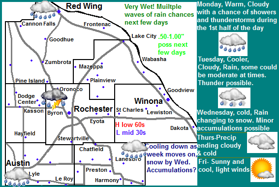
For us here in Southern Minnesota expect that our weather over the next few days will be anything but consistent. Monday will be warm and stormy with highs in the 60s, by Wednesday temps will cool to the low 40s. It will be very wet the next few days with precipitation amounts exceeding 1-2" amounts a high possibility. Here is a breakdown of the weather for the next few days. Monday the stationery front mentioned above will be sitting right over the area bringing mild air up into the 60s from regions to our south. Showers and thunderstorms will be likely during the morning hours,m some of which could bring heavy downpours. Rain will come to an end in the afternoon with a partly sunny sky during the afternoon with highs rising to the low to middle 60s.
Cooler Tuesday with more rain-possibly heavy at times
Tuesday, The day will start off cloudy with more rain pushing into the area in the afternoon. Moderate rain is a possibility with the off chance for thunder. Highs will rise to the upper 40s before cooling off.
Wednesday-much colder rain/snow
Wednesday will be much colder with the chance for rain changing to snow. Highs will be in the upper 30s to low 40s. The snow may accumulate to a slushy inch or two before quickly melting away due to warm temps.
Thursday/Friday drying out
Thursday and Friday our precip chances come to an end and we begin to dry out. Thursday will be cloudy and cold with temperatures in the upper 30s and lows falling way below freezing into the middle 20s. Friday we will get to see the sun again, but it will be a fairly cool day with highs in the low to mid 40s.
Monday, Showers and thunderstorms in the morning, then party sunny in the afternoon, warm with highs in the lower to mid 60s. Monday night, Cloudy with a chance of drizzle late. Lows in the low 40s.
Tuesday, Rain, moderate downpours are possible with the chance for thunder. Cloudy skies, highs in the upper 40s. Tuesday night, Light rain, Cloudy with lows in the middle 30s
Wednesday, Much colder, Cloudy with rain developing possibly mixing with snow. Precip changing to all snow late. Wednesday night. Precip changing to all snow late. Slushy minor accumulations possible, lows in the upper 20s.
Thursday, A small chance of rain or flurries early, other wise cloudy and cold with highs in the upper 30s to lower 40s. Thursday Night, Cloudy and cold, lows in the middle 20s.
Friday, Sunny and cool, light winds with highs in the low to mid 40s. Friday Night, Increasing clouds, lows in the mid 20s.
Weather pattern ahead looks cool through the middle of the month with warm up long term.
Saturday at this point looks warmer and dry with highs again apporaching the 50s. Sunday rain moves back in from the west with heavy snow across the northern part of Minnesota as the jet stream gets pushed south. Monday the 15th it shows something I'd rather not mention, but shows a low pressure system riding the jet stream as it is unusually far south for this time of year, this would spread rain in Iowa with a breif shot of snow across our area. Its really too early to tell if that will materialize but one this is for sure the models are consistent with a cold airmass coming in for the middle of the month around the 17th, which brings several days of cold days way below normal. Most of those days look to be dry and sunny, but a weak systems brings more snows across Northern Minnesota, leaving our area alone. The models have also been consistent with this significant change as well, sometime arouht Sunday the 21st the jet stream is gets kick well to the north into Canada bring our temperatures right from a very cool pattern right into a very warm pattern coming our way for the end of the month.


No comments:
Post a Comment