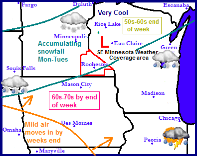
Regional weather view.
The wet cool pattern that has been in place for some time now will continue for at least a few more days... Another snow event is expected to happen in Minnesota and Wisconsin as accumulating snowfall is possible, but an end of this pattern is in sight, but weeks end the cold air will begin to break down as warmth floods into the region bringing spring-like temperatures and drier weather conditions.
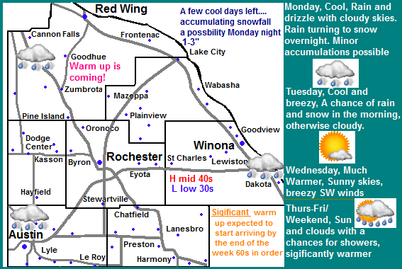
Local weather view.
We've got a few more days of this crummy wet pattern-to be honest we even have the threat for accumulating snowfall Monday night into the 1st part of Tuesday as a system slides across the area. Rain will develop tomorrow with amounts around quarter to three quarters of an inch, the rain will be changing to snow will occur tomorrow night. 1-3" of wet sloppy snow could accumulate and like in the past few days it will melt very quickly. Monday highs will be in the upper 40s early then remain in the middle to low 40s the rest of the day. Tuesday will be cold with cold strong north winds. Highs will be in the upper 30s to lower 40s, with lows falling into the upper 20s, this will be the last of the coolest air and wet weather for awhile.
HERE comes the warm up! Wednesday-through end of the week
The weather everyone has been waiting for will show us a taste Wednesday and Thursday it will be sunny and much warmer as high pressure moves into the area. This will be the start of a long term warm up across the region. With sunny skies expected and southwest winds developing, we can expect 50s for highs both days with lows around the low to mid 30s both nights. We are on the verge of experiencing beautiful weather! Friday, Saturday and Sunday significant warmth will flood into the region on southwest winds, highs as warm as the low to mid 60s for the 1st time this season can be expected. There is a chance some areas may flirt near 70.F degrees, with lows in the 40s. all 3 days look to be partly cloudy and will feature pleasant amounts of sun. There is a small threat for showers possibly a thunderstorm Sunday, but it looks fairly light at this time.
Monday, Cool, Cloudy, Rain, highs in the upper 40s before cooling down. Breezy Northwest winds. Monday Night, Cold, Rain and snow likely. Snowfall accumulation 1-3" Lows in the lower 30s.
Tuesday, Cold and breezy. Northwest winds 25-30MPH Rain/Snow in the morning otherwise cloudy with highs in the lower 40s. Tuesday Night, Cold! Clearing skies with lows in the upper 20s.
Wednesday, Much warmer. Sunny skies, breezy southwest winds to 30MPH. Highs in the low 50s. Wednesday Night, A chance of light rain and snow, cloudy with lows in the low 30s.
Thursday, Sunny skies, light winds, highs in the lower 50s. Thursday Night, Clear skies, lows in the upper 30s.
Friday, Nice! Breezy south winds with Sunny skies, highs in the lower to mid 60s. Friday Night, Partly Cloudy with lows in the mid 40s.
Saturday, Nice! Partly cloudy with highs in the lower to middle 60s. Saturday Night, Partly Cloudy with lows in the upper 40s.
Sunday, Nice! Partly cloudy with a chance of a shower or thunderstorm. Highs in the upper 60s to lower 70s, breezy south winds. Sunday Night, Partly Cloudy with lows in the upper 40s to low 50s.
Warm up progression continues in long term
The long range charts continue to favor this current pattern finally ending. Monday the 29th a cold front pushes through bringing a chance for showers and thunderstorms, then cooler temperatures and a dry sunny day back down into the 50s for Tuesday the 30th. The middle of next week which will be the 1st part of May looks dry and sunny with many days with highs in the 60s, possibly 70 degrees. Friday the 3rd unsettled weather brings the chances for showers and thunderstorms which lasts into Saturday. There is no cold air following this system. Following this into the 2nd full week of May, the weather looks to continue to warm up an remain relatively dry. I see the threat for more 60s possibly an 80 not far off, but that may be going too far. A return to a more stormy, possibly slightly cooler pattern back be in store for us during the middle part of May according to this model


No comments:
Post a Comment