Regional weather view
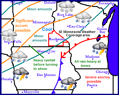
A fairly active pattern continues as a couple waves of storms will be pushing through the region. The reason for the active pattern is that the jet stream continues to be located right over the area, this feature is continuing the winter that doesn't end for some across the region as yet another winter storm is expected for parts of Minnesota, South Dakota and Northern Wisconsin. Accumulation snowfall is possible as far south as Northwest Iowa. Significant amounts of moisture will also be seen with this storm as heavy rains develop across Southeast Minnesota, most of Iowa, Wisconsin and Illinois. Flooding is possible as 1-3" of rain is expected. Some area will get some of both worlds seeing both heavy rain and accumulating snowfall.
Local and Metro views.
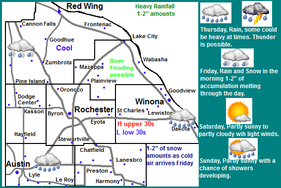
Cool and wet are the words that can be used to describe our weather for the next few days as we continue to be stuck in this same pattern that wont be changing for at least the next several days. A significant storm system will be effecting our area over the next couple days. First we will see rain, some of which could be heavy at times. Rain amounts from this will be around 1-2" which could cause problems with river flooding of which will mostly be the minor type. Colder air will begin to move into the area Thursday night which will turn the rain to snow Thursday Night into Friday Morning and will likely accumulate to 1-2" if the wet ground can allow for this much accumulation. All of the slushy type snow will melt during the day Friday or Saturday. Temperatures will continue to be well below normal only from where they should be in the mid to upper 50s, we can expect highs in the upper 30s through Friday, with lows anywhere from the lower 30s to as cold as the lower 20s Friday Night. Saturday is the next chance for a dry day. At this time it looks to be sunny with highs in the upper 40s, but its difficult to say if the chances for sun can hold, it should be a good bet that it will be dry though. This try streak is unfortunately looking to be short lived as the chances rain possible mixing with snow again begin to increase again Sunday, rain amounts will be closer to the 0.25-0.50" range with little to no accumulation from the snow.
Thursday, Rain, heavy at times. Thunder is possible. Rainfall amounts from Wednesday-Thursday Night 1-2" Thursday Night, Rain, mixing with and changing for sleet and snow. Lows in the lower 30s
Friday, Cold and breezy! Snow and sleet in the morning before ending, snow accumulations 1-2" drizzle possible in the afternoon. Highs in the upper 30s. Friday Night, Cold! Partly cloudy skies with lows in the low to mid 20s.
Saturday, Partly Cloudy skies, light winds with highs in the mid to upper 40s. Saturday Night, Partly Cloudy with lows in the low 30s
Sunday, Partly Cloudy with the threat for showers increasing. Highs in the upper 40s. Sunday Night, A chance of rain mixing with snow. Little to no snow accumulation, lows in mid 30s.
Will it ever warm up? Drier warmer weather expected in coming weeks.
The models continue to show a break down of this pattern in the coming weeks and the both models seem to agree, it will just take some time to break this pattern, at some point however it will break and the models do try to show this. Monday we will keep the threat for rain with warmer temperatures at least in the 40s. Rainfall amounts look fairly light. Tuesday and Wednesday look cool for April standards, but warmer then it has been it also appears it will be sunny and highs. Thursday through Sunday the 28th the models continue to keep a drier pattern over our area with good chances for sun. As warmer air pushes in from the west we will have a chance for our highs possibly up to near as high as 60.F as early as the late part of next week. Monday the 29th through the 1st part of May the models show the weather becoming more disturbed with chances for showers and thunderstorms between the date listed above and the 3rd of May. a cool chilly drier air follows behind this storm system, and that is what the extended forecast shows.


No comments:
Post a Comment