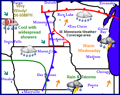
Continuing a more active streak here in the Upper Midwest this week with our next storm system entering in from the west, this time bringing the northern states much needed rainfall. A strong low pressure system will move across North Dakota into Minnesota. Spreading widespread scattered showers across South and North Dakota, Minnesota, Northeast Iowa, Wisconsin and Illinois. In the south thunderstorms will be possible. Behind this low pressure winds will become very gusty with wind gusts 50 to 60MPH. High wind warnings are in place for that region. As this system moves away over the weekend quieter, and warmer weather will move in for the weekend with warming temperatures to more seasonable normals.
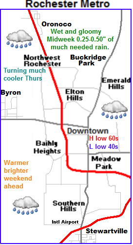
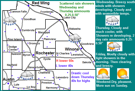
Local view and Metro view.
 This storm system for us will mean a chance to see much needed rainfall in which we have been lacking for quite a while now. Being on the southerly side of the system on Wednesday we can expect to a cloudy and warm breezy day Highs will be in the lower 60s and Winds will gust to 35MPH at times before the cold front pushes through. With the passing of this cold front showers will develop and push in during the day. These showers will be light, possibly moderate in nature, then the showers will end and there will be a break from the precipitation. Lows will be in the lower 40s. Thursday being behind the cold front will be significantly cooler with cloudy skies. We can expect highs only in the middle to upper 40s with breezy conditions at times. Showers and drizzle will re develop in the afternoon, and will be off and on from the late afternoon through the night. Total 2 day rainfall should be 0.25 to 0.50" with the chance for it to be more or less. Friday will be mostly cloudy with a chance of that rain continuing in the morning. It will be breezy with winds to 30MPH. The afternoon will remain cloudy with highs in the upper 40s to lower 50s. There may be some cloud breaks in the afternoon. Friday night will be Cloudy with lows in the upper 30s to lower 40s.
Brighter weekend
The weekend looks much brights and better for weather. We can expect Clearing skies Saturday with highs in the upper 50s, and lows in the lower 40s. Sunday will be the best day out of the 2 with a beautiful calm day with highs in the middle to upper 60s and lows in the middle to upper 40s.
Wednesday, Seasonable temps. Cloudy and breezy with winds gusting to 30MPH. Showers developing in the morning to afternoon. Highs in the lower 60s. Wednesday Night. Cloudy with lows in the lower 40s.
Thursday, Much cooler. Cloudy and breezy. Showers and drizzle developing in the morning to afternoon. Highs in the mid to upper 40s. Thursday Night, Showers and drizzle. Lows in the lower 40s. 2 day rainfall amounts ranging from 0.25 to 0.50.
Friday, A chance of rain or drizzle in the morning. Otherwise cloudy and breezy with highs in the lower 50s. Friday Night, Mostly Cloudy, lows in the upper 30s to lower 40s.
Saturday, Clearing skies. Highs in the upper 50s. Saturday Night, Clear skies, lows in the lower to mid 40s.
Sunday, Pleasant. Sunny and warm with highs in the mid to upper 60s. Sunday Night, Increasing clouds. Lows in the upper 40s.
Looking Ahead
Monday clouds will increase and the chance for light showers will again enter the picture, but they look fairly light at this time. Temperatures look to be seasonable. Tuesday through Friday look clear and dry. With temperatures starting out seasonable on Tuesday seasonable and ending out quite warm on Thursday. We could have highs in the 70s. Saturday and cold front pushes through bringing very little rain with it. Sunday looks cloudy and cool. Monday the 29th is the next interesting storm system in the models. Even more interesting, it has been showing a few runs now which may indicate some consistency. It's showing a low pressure system going from Nebraska to Minnesota, spreading heavy rains, and high winds across the region, with far Northwestern Minnesota dealing with snow and wind. Thunderstorms are a possibility in our area. Tuesday the 30th looks significantly colder behind this storm. With below freezing highs a possibility. It remains on the cooler and dry side through November 1st.


No comments:
Post a Comment