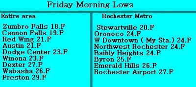
Temperatures bottomed out to their coldest levels of the season so far, dropping to the teens to lower 20s across much of the area which is more typical of November. Average lows are expected to be in the upper 30s to lower 40s this time of year. The cause of the cold air was the passes of a cold front bringing in cooler Canadian air from the northwest. The low at my station was 24.F which is the coldest so far of the season. An interesting fact that I noticed with this cold snap is the airport in the country fell to 27.F while here in the city the low was 3 degrees colder at 24.F. This is the first time during a cold snap that I've actually seen a low temperature colder in the inner city areas they the outlying airport.
Lows reported Friday Morning.
The coldest temperatures were in the northern areas and river valleys. Cannon Falls and Zumbro Falls both had lows in the upper 10s. Warmest temps reported were of that in areas in the south and along the Mississippi River.

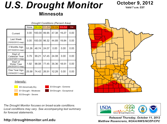
Image from U.S Drought Monitor
As another shot of what was supposed to be promising beneficial rains misses the area, Drought conditions are becoming a serious factor here in Southeastern Minnesota and many are wondering when this streak of dry weather will end. Dry conditions seemed to have started over a year ago in August of 2011. Since that time rainfall has been un reliable going from having enough rain to not enough very easily. Decent summer rains across the area were only in spotty areas at best that were lucky enough to get in on some of the summer thunderstorms that we had. But in September it turned very dry and many areas are now way below normal for both September and October so far. The NWS in La Crosse has been keeping very good track on the drought conditions as they have continued to develop. NWS La Crosse says rainfall deficits since January 1st in some of the worst areas range from -10.95" at Austin to -7.44" at the Rochester Airport to -7.63" at Preston If you go back to around when the drought started in 2011 deficits go as high as -19.51" for Austin -15.48" for Rochester Airport and 15.75" for Preston. Soil moisture levels across the area are very low and recent rains that have only seemed to "spoon feed" the soil are not helping much in the way of reducing drought. Hopefully we can continue to get into a long term wetter pattern that can bring healthy rains back to Minnesota.
The map above shows certain parts of counties in the following status
Extreme Drought For the Southwestern 1/2 of Mower County effecting Austin and surrounding areas.
Severe Drought For Southern Dodge, Northwestern Mower, Southern Fillmore, Eastern Winona, Eastern Wabasha counties.
Moderate Drought For Goodhue, Olmstead, Northern Dodge, Western Wabasha, Western Winona, Northern Fillmore counties.


No comments:
Post a Comment