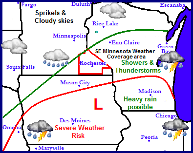
The regions next weather maker will be the main story in the states of Iowa and Wisconsin as a fairly strong low pressure system tracks from Kansas across Iowa and then into Wisconsin. This feature will spread widespread showers and thunderstorms with heavy rains across Eastern Iowa and Southern Wisconsin. Severe weather with damaging winds, hail and tornados are possible mainly in Southern Iowa, Illinois and Southern Wisconsin. There will be a sharp cut off in the rain to the Northwest where most of Minnesota and Northern Wisconsin will miss out on the bulk of the heaviest rains.
Note: The forecast has been updated.
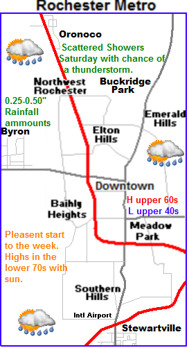
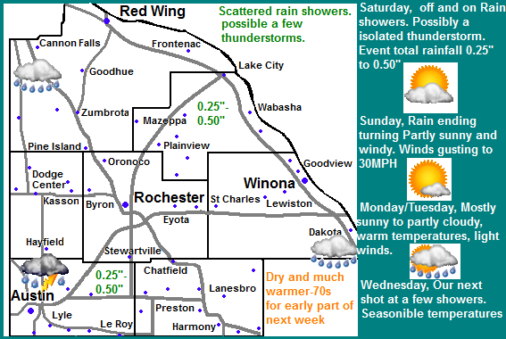
 Saturday Rain, will continue to be the biggest story local area. The low pressure system tracking across Iowa is forecasted to bring rains even here in Southeastern Minnesota. Unfortunately models have significantly decrease amounts because the system has been trending further south. The severe weather risk is also now very low. Showers and look to start Friday Night and will be off and on all throughout Saturday into Saturday night. Even though amounts have been lowered it will still be the most rainfall we've seen in a month with amounts ranging from 0.25 or less in Northwest areas to around 0.50 in Southeastern areas, with possibly a bit more in localized areas. Sunday there will still be a chance of showers in the morning, otherwise we can expect dry conditions with partly sunny skies. Winds will be quite gusty Sunday out of the Northwest up to 30MPH. Highs will be in the lower 60s with lows in the upper 30s to lower 40s. Monday will be much nicer and even quite warm as well. We can expect sunshine to return with highs approaching 70 degrees, we can expect a much warmer night with lows in the upper 40s Monday night as clouds increase. Tuesday will be fairly cloudy, but highs will still be in the upper 60s to lower 70s range. Lows will remain in the upper 40s to lower 50s area.
Next shot of much needed moisture.
Wednesday is the next shot of moisture in which all of the area desperately needs. At this time it does not look like much maybe around 0.25" but this is our next chance of rain. Highs will be in the lower 60s with lows in the lower 40s because of the expected rain and clouds
60s with lows in the lower 40s
Saturday, Showers and thunderstorms off an on through the day. Highs in the upper 60s. Saturday Night, Showers. Total event rainfall amounts around 0.25" to 0.50" Lows in the upper 40s.
Sunday, Breezy, Winds gusting to 30MPH Partly sunny with clearing skies. Highs in the lower 60s. Sunday night. Partly cloudy with lows in the upper 30s to lower 40s.
Monday, Sunny and warm! Highs in the upper 60s to lower 70s. Monday Night, Partly Cloudy, lows in the mid to upper 40s.
Tuesday, Partly cloudy to partly sunny. Highs in the upper 60s to lower 70s. Tuesday Night, Increasing clouds, lows in the upper 40s.
Wednesday, Cloudy with a chance of light rain showers. Highs in the lower 60s. Wednesday Night, Cloudy, a chance of light showers. Lows in the upper 40s.
Looking Ahead
Even though the models have trended this weekends more southward with this weekends the still seems to be a signal a significant change to a wetter pattern. The models continue to show multiple chances for rain for the rest of the month. After Wednesday it is calm and warm through Friday, then a dry cold front passes through cooling things down on quite cool on Sunday the 21st, then it warms back up to seasonable levels Monday the 22d with a small change a few rainshowers around. Then around Wednesday October 24th a much stronger storms system arrives. Models show a large low pressure system tracks from Iowa through Central Minnesota, spreading widespread rain and thunderstorms in our part of the state, and even heavy snows in Northwestern Minnesota and North Dakota. Very cold air and very windy conditions follow this storm Thursday the 25th, highs may struggle to get above 32.F. More calm weather follows this system as we near the end of October.


No comments:
Post a Comment